About Chute à Wallace
Chute à Wallace is a remote waterfall on Anticosti Island, Quebec, located in the general vicinity of Port-Menier (approximately 62.6 miles / 100.7 km from Port-Menier by straight-line distance as reported). Coordinates provided are 50.328, -65.2381. The fall is set in boreal/mixed forest typical of Anticosti and is likely best accessed from local forest roads or trails. Detailed, authoritative trail descriptions and a confirmed measured height are not readily available in major trail databases; the following information is based on regional context and visitor-report style sources and should be treated as provisional.
Why This Waterfall Exists
Chute à Wallace flows over hard intrusive rock laid down over 1.0-1.6 billion years ago. These resistant rocks form a durable ledge that water cannot easily wear away, creating the falls where softer material downstream has already eroded.
Trail & Hike Details
Trail Description
There is limited formal trail documentation for Chute à Wallace. Approaches on Anticosti Island commonly involve unpaved forest roads and short informal trails or bushwhacks from the nearest road or river access. Trails, if present, may be uneven, muddy, and poorly marked. Visitors should be prepared for backcountry navigation, route-finding, and potentially wet or marshy ground near river corridors.
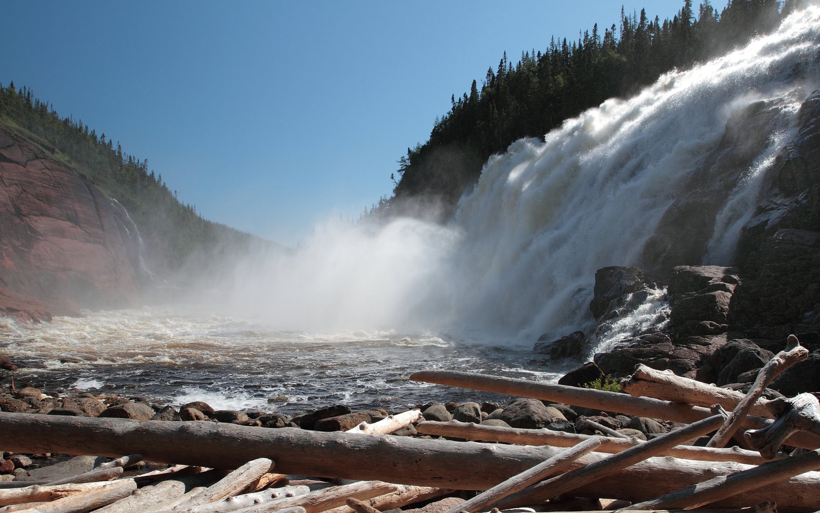
What to Expect
Expect a remote waterfall setting surrounded by boreal/mixed forest typical of Anticosti Island. Water flow may be seasonal: higher in spring during snowmelt and after heavy rain, lower in late summer. Terrain near the water may be rocky and slippery; banks can be steep. Wildlife in the area commonly includes large numbers of white-tailed deer (the island is known for its deer population) plus abundant seabirds along the coast and smaller mammals. Cell service is often limited; services and rescue response are remote.
Accessibility
Accessibility information is not documented; the site is likely not wheelchair accessible due to rough, unpaved roads, uneven ground, and natural obstacles. Remote location and informal trails make access challenging for visitors with limited mobility.
Frequently Asked Questions
🐶 Are Dogs Allowed at Chute à Wallace?
❌ Dogs are not allowed
Are There Any Fees or Permits Required?
🆖 No fees required
🏊 Is There Swimming at Chute à Wallace?
❌ Swimming is not allowed
When to Visit
Late spring (snowmelt) to early summer often gives the most robust water flow. Summer offers the easiest access conditions for travel on island roads but can have many insects. Early fall provides good color and fewer bugs; winter access may be possible but road closures, snow and remoteness can make travel difficult.
Seasonal Access
The best time to visit is Spring, Summer, and Fall. Winter access may be limited. Check with the managing park or local authority for current conditions.
Safety Information
Hazards include slippery rocks, steep or unstable banks, strong currents near the falls, black flies and mosquitoes in warm months, rapidly changing weather, and very limited cell coverage and emergency services. Travel to Anticosti Island requires planning, carry emergency supplies, tell someone your route and expected return, and check local conditions in Port-Menier before setting out. Do not attempt river crossings in high water. If unsure about conditions or your route, use a local guide or contact local authorities for advice.
Know when to go.
Get a free email alert when waterfalls near Port-Menier hit peak flow. We only send when conditions are worth the trip — no weekly newsletters, no spam.
Weather Forecast
Location & Access
Getting There
Chute à Wallace is on Anticosti Island, Quebec. Access to Anticosti Island normally requires a scheduled flight or boat to Port-Menier. From Port-Menier, access to interior features is by local roads (often unpaved) or trails; exact trailhead locations for Chute à Wallace are not well documented. Use the provided coordinates (50.328, -65.2381) with a GPS device or offline map. Expect limited signage and little to no cell coverage in many areas of the island.
Get Directions on Google MapsParking
Parking information is not well documented. If a trailhead or informal pullout exists, parking is likely informal and unpaved. Visitors should plan to park only in established or clearly used areas and avoid obstructing private access.
Elevation
81 metres above sea level
Coordinates
50.328001° N, -65.238107° W
Visitor Tips & Gear
1) Confirm current access and any advisories locally in Port-Menier before attempting a visit. 2) Use GPS coordinates and bring a reliable offline map; trail signage may be absent. 3) Insect repellent and head nets can be essential in spring and summer (black flies/mosquitoes). 4) Wear sturdy, waterproof footwear and be prepared for slippery rocks and roots. 5) Pack out all waste and respect private or managed land. 6) Plan for limited services, carry extra fuel, water, and emergency supplies.
Where to Stay
Browse vacation cabins and private rentals nearby
Unique outdoor stays — tents, yurts, and treehouses
Rent a campervan or RV for your waterfall road trip
Some links are affiliate links. We may earn a commission at no extra cost to you.
Nearby Campground
camping, VR gratuit
20.4 km away
Additional Information
Nearby Attractions
Port-Menier (main settlement on Anticosti Island) offers basic services. The island has coastal viewpoints, cliffs, bird colonies, and other rivers/streams with smaller falls or rapids. Many visitors travel to see wildlife (notably white-tailed deer) and coastal scenery.
Wildlife
Anticosti Island is notable for its large population of white-tailed deer. Expect seabirds along the coast, small mammals, and typical boreal forest bird species. There are no guarantees about sightings; maintain distance from wildlife.
Cities near Chute à Wallace
Nearby Waterfalls
Writing about Chute à Wallace? Embed this waterfall on your site for free.