Difficulty
Hard
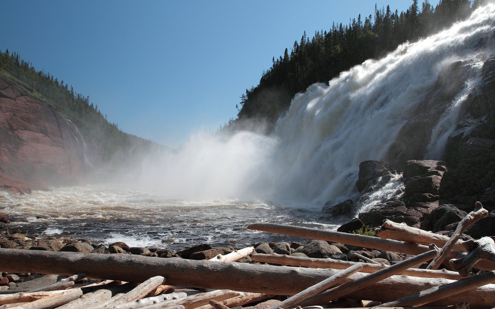
About Chute à Aubin
Chute à Aubin is a remote waterfall on Anticosti Island, Quebec. Based on provided coordinates (50.3245, -65.2388) it lies in a boreal/taiga landscape typical of the island: dense forest, river valleys and sandstone/limestone bedrock. The waterfall is not well documented in mainstream trail guides and appears to be a backcountry feature reached by logging/forest roads or long cross-country travel from the nearest settlement (Port‑Menier). Visitors should plan for a remote, minimally developed site with no facilities.
Why This Waterfall Exists
Chute à Aubin flows over hard intrusive rock laid down over 1.0-1.6 billion years ago. These resistant rocks form a durable ledge that water cannot easily wear away, creating the falls where softer material downstream has already eroded.
Trail & Hike Details
Trail Description
There is no widely published, maintained trail description for Chute à Aubin. Expect a route that may include travel on unsurfaced forestry tracks, cross-country hiking through boreal forest, river or creek crossings, and route‑finding over uneven bedrock and wet terrain. Because documented trail information is scarce, approaches are typically treated as backcountry navigation trips rather than day‑use strolls. Plan for a multi‑hour to multi‑day approach depending on your starting point and exact access route.
What to Expect
You will likely encounter boreal forest (spruce, fir, birch), muskeg/peat in low areas, exposed bedrock and a narrow river or stream feeding the falls. Flow may vary seasonally, higher in spring and after heavy rain, lower in late summer. There are unlikely to be amenities (restrooms, signage, maintained viewpoints). Insects (black flies, mosquitoes) can be numerous in late spring and summer. Cell coverage may be nonexistent; navigation and safety equipment are recommended.
Accessibility
The trail involves steep, uneven terrain with significant elevation change and is not accessible to mobility devices.
Frequently Asked Questions
🐶 Are Dogs Allowed at Chute à Aubin?
❌ Dogs are not allowed
Are There Any Fees or Permits Required?
🆖 No fees required
🏊 Is There Swimming at Chute à Aubin?
❌ Swimming is not allowed
When to Visit
Late spring (snowmelt) to early fall is typically best. Spring usually has higher water flow which makes the falls more impressive; summer offers easier travel conditions but potentially lower flows; fall brings cooler temperatures and fall color. Winter access is difficult due to snow and ice and is not recommended unless you are experienced in winter backcountry travel and have appropriate equipment.
Seasonal Access
The best time to visit is Spring, Summer, and Fall. Winter access may be limited. Check with the managing park or local authority for current conditions.
Safety Information
This is a backcountry location. Hazards include: remote location with limited or no cell coverage; variable and rapidly changing weather; slippery wet rocks and unstable cliff edges near the falls; possible river currents and deep pools; biting insects in summer; poor or seasonal road conditions. Carry navigation and emergency communication tools, tell someone your plans, and be prepared to turn back if conditions are unsafe. Check weather and local transport schedules before travel. If you are inexperienced in remote navigation, hire a local guide.
Know when to go.
Get a free email alert when waterfalls near Port-Menier hit peak flow. We only send when conditions are worth the trip — no weekly newsletters, no spam.
Weather Forecast
Location & Access
Getting There
Chute à Aubin is on Anticosti Island. Access to the island is by scheduled air service to Port‑Menier or by seasonal ferry from the mainland. From Port‑Menier the waterfall location is approximately 62.4 miles (as supplied), which implies a long overland approach by island roads/tracks or a multi-day backcountry route. Expect limited or unmaintained roads; 4x4 or all‑terrain travel and local knowledge may be required. There is likely no marked public trail from Port‑Menier to the falls.
Get Directions on Google MapsParking
No formal parking lot is known for this feature. Where forest roads exist, parking is likely informal at pullouts or trailheads. Park considerately off the road and avoid blocking gates or tracks. If approaching from Port‑Menier, verify parking/vehicle rules locally before leaving a vehicle.
Elevation
80 metres above sea level
Coordinates
50.324515° N, -65.238790° W
Visitor Tips & Gear
• Treat this as a backcountry visit: tell someone your plan and expected return time. • Bring a topographic map, compass and GPS, trails may be unmarked. • Expect black flies and mosquitoes in spring and summer; bring repellent and protective clothing. • Footing can be slippery on wet rocks and near the waterfall, exercise caution near edges. • There are likely no facilities or garbage services; pack out everything you bring. • Verify transport schedules for ferries or flights to/from Anticosti Island well in advance. • If unsure about road conditions or route‑finding, consider hiring a local guide or contacting authorities in Port‑Menier for current conditions.
Where to Stay
Browse vacation cabins and private rentals nearby
Unique outdoor stays — tents, yurts, and treehouses
Rent a campervan or RV for your waterfall road trip
Some links are affiliate links. We may earn a commission at no extra cost to you.
Nearby Campground
camping, VR gratuit
20.3 km away
Additional Information
Nearby Attractions
Port‑Menier (community services and transport hub), coastal cliffs and sea‑bird colonies around Anticosti Island, other inland rivers and small falls and scenic viewpoints on the island. Exact nearby named attractions depend on which roads/approach are used.
Wildlife
Anticosti Island is known for abundant white‑tailed deer and a variety of seabirds. Visitors may also encounter foxes and marine mammals along the coast. Insects (mosquitoes, black flies) are common in warmer months. Always observe wildlife from a distance and avoid feeding animals.
Cities near Chute à Aubin
Nearby Waterfalls
Writing about Chute à Aubin? Embed this waterfall on your site for free.