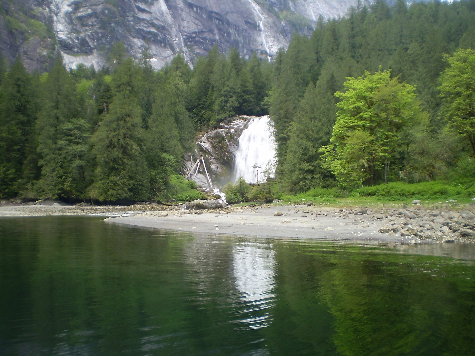
Chatterbox Falls
British Columbia • Princess Louisa Marine Park • 37 m
By Armen Suny · Last verified Jun 2026
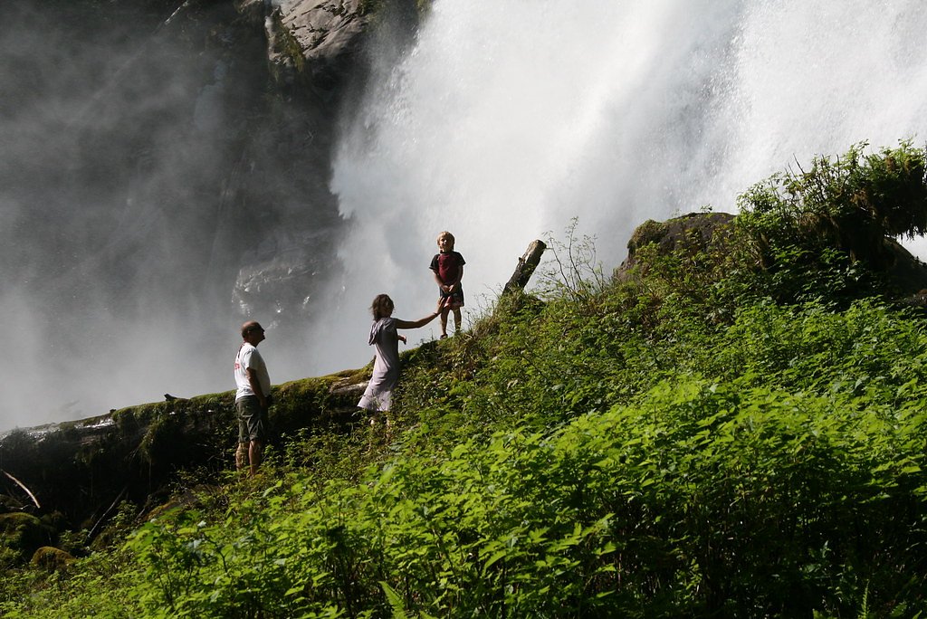
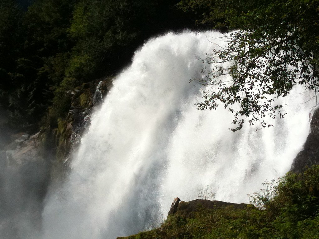
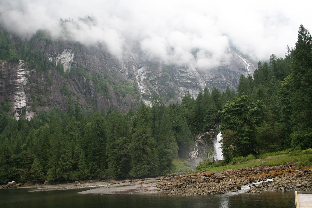
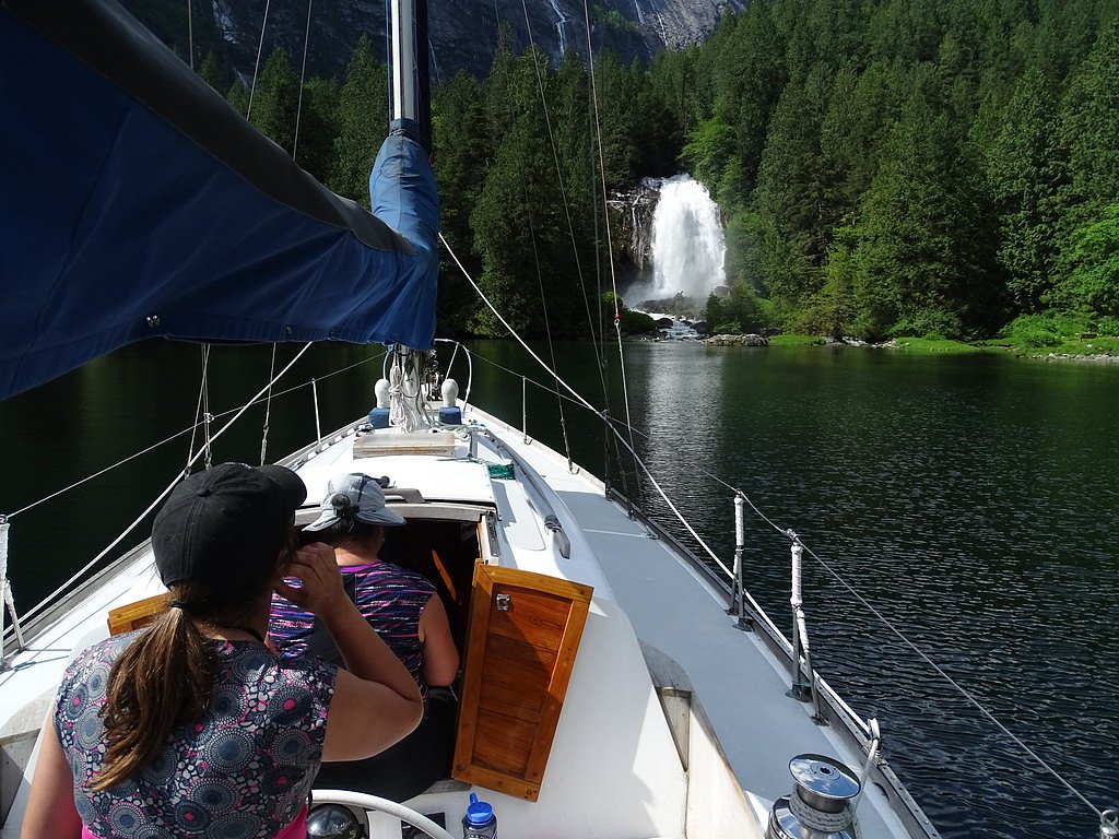

Photo Credits (5)
Difficulty
Easy
Trail Length
0.5 km
Trail Type
Out And Back
Elevation Gain
6 m
About Chatterbox Falls
Chatterbox Falls is a waterfall in British Columbia, Canada, located at the head or end of Princess Louisa Inlet. It is part of Loquilts River which empties into the inlet. The falls are a popular destination for boaters around the world and are in Princess Louisa Marine Provincial Park, part of BC Parks' marine park system which manages the area with the cooperation of the Princess Louisa International Society.
The Setting
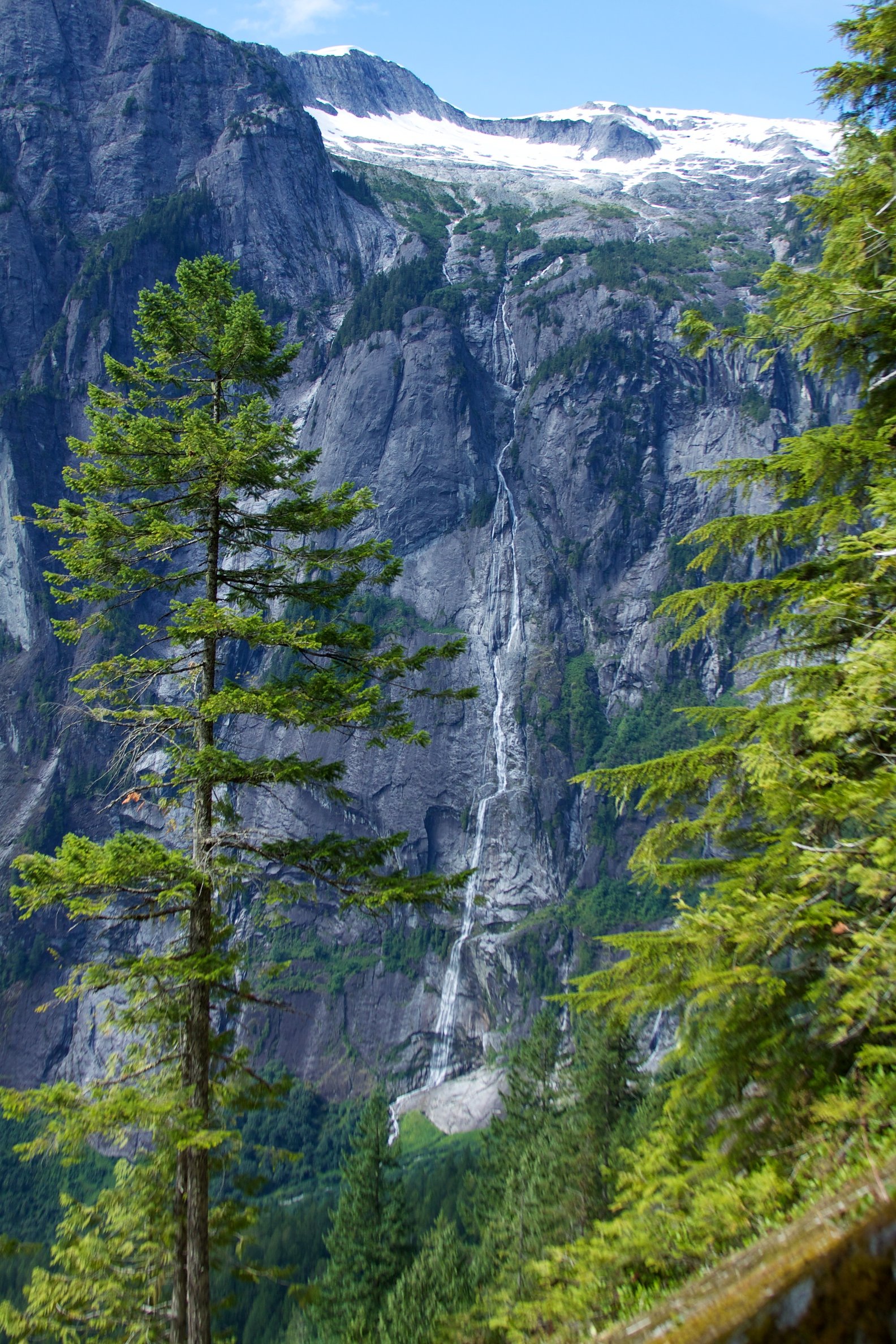
Chatterbox Falls sits at 9 metres within Princess Louisa Marine Park, in the coastal lowlands of British Columbia. At 37 metres, it is among the taller waterfalls in British Columbia.
Why This Waterfall Exists
Chatterbox Falls flows over hard intrusive rock laid down about 66-145 million years ago. These resistant rocks form a durable ledge that water cannot easily wear away, creating a 120-foot drop where softer material downstream has already eroded.
Nearby Falls Worth Visiting
James Bruce Falls, the tallest waterfall in British Columbia at 840 metres, lies 1.4 kilometres to the northwest.
Trail & Hike Details
The Approach
The easy 0.5-km out-and-back trail gains 6 metres of elevation on the way to the falls.
Trail Description
From the park dock there is a short, well-used trail through coastal forest that leads to a viewing area at the base of the falls. The walk is brief and mostly flat; surfaces may be uneven, muddy or have exposed roots. The primary experience is the view from the shoreline and the rock/sand beach area near the outflow into the inlet.
What to Expect
The falls cascade 37 metres over hard intrusive rock.
Accessibility
The trail is short and relatively flat, but the surface may be uneven. Contact the managing agency for accessibility details.
Frequently Asked Questions
🐶 Are Dogs Allowed at Chatterbox Falls?
❌ Dogs are not allowed
Are There Any Fees or Permits Required?
🆖 No fees required
🏊 Is There Swimming at Chatterbox Falls?
❌ Swimming is not allowed
When to Visit
Late spring and summer are the most popular times for pleasant weather and easier boating conditions; spring and early summer can offer higher flows from snowmelt, while fall may be quieter. Winter access is possible by boat/floatplane but can be hazardous due to weather and sea conditions.
Seasonal Access
The best time to visit is Spring, Summer, Fall, and Winter. Check with Princess Louisa Marine Park for current conditions.
Safety Information
Primary hazards: marine travel risks (weather, waves, tides, and navigation), limited or no cell service, cold water and strong currents near the falls, slippery rocks and uneven trail surfaces, and potential encounters with wildlife. Check weather and marine forecasts before travel, wear life jackets, file a float plan, and carry communication devices suitable for marine emergency use. Err on the side of caution if conditions are marginal.
Current Water Conditions
Based on a Water Survey of Canada gauge 26.5 km away
176.0 m³/s
Current discharge — how much water is flowing
Lower than usual for this time of year
Based on 43 years of record
4.09 m
Water depth at gauge
7-Day Discharge Trend
What does this mean for your visit?
Flow is lower than usual for this time of year.
About This Gauge
This gauge is on a regional waterway. Conditions at the falls may differ, especially after local rain.
7-Day Flow Outlook
Based on the WSC gauge ELAHO RIVER NEAR THE MOUTH (27 km away).
Today
Moderate
192 m³/s
6/10Tomorrow
Moderate
196 m³/s
8/10Tue
Moderate
191 m³/s
6/10Wed
Moderate
189 m³/s
6/10Thu
Moderate
190 m³/s
6/10Fri
Moderate
204 m³/s
5/10Sat
Moderate
220 m³/s
5/10Best window: Tomorrow — moderate flow, sunny (trip score 8/10).
Best time of year: this gauge typically runs highest from late May to mid August, peaking in July.
How we calculate this
This is a transparent outlook, not a precise forecast. We take the waterfall's current flow strength (how it ranks against its historical normal for today, from the nearest WSC stream gauge), carry that ranking forward along the gauge's seasonal curve, and nudge it for forecast rain. Confidence is highest for the next day or two and falls further out. Always check official conditions and your own judgment before visiting — high flows can be dangerous.
Know when to go.
Get a free email alert when waterfalls near Powell River hit peak flow. We only send when conditions are worth the trip — no weekly newsletters, no spam.
Weather Forecast
Location & Access
Getting There
Chatterbox Falls is located at the head of Princess Louisa Inlet. There is no road access; visitors arrive by private boat, kayak, tour boat, or floatplane. Common embarkation points include Powell River (by boat charter or private vessel) or the Sunshine Coast/Desolation Sound area. The falls are approximately 48.8 miles (straight-line) from Powell River; actual travel routes are by water and longer.
Get Directions on Google MapsParking
No vehicle parking at the falls. Park your vehicle in the nearest town (Powell River or other Sunshine Coast communities) and arrange boat, water-taxi, charter or floatplane transport. If using a private vessel, plan for anchoring/mooring at the park dock or using designated mooring buoys where provided.
Elevation
9 metres above sea level
Coordinates
50.207227° N, -123.771011° W
Land Management
Managed by Government of British Columbia
Visitor Tips & Gear
Arrange safe, reliable water transport in advance (charter, water taxi or floatplane). Wear layered, waterproof clothing and sturdy shoes for the short trail. Bring life jackets for all passengers and follow marine safety rules. Pack insect repellent and sun protection. Respect park rules: pack out all waste and follow any posted mooring/camping instructions. Expect limited or no cell service; leave trip plans with someone onshore. Be cautious around wet rocks and the shoreline, surfaces are slippery and currents can be strong.
As an Amazon Associate, we earn from qualifying purchases.
For this easy 0.5 km trail, lightweight trail shoes and a water bottle are usually sufficient. Icy conditions are common in winter — traction cleats are a smart addition.

Columbia Watertight II Rain Jacket
Packs into its own pocket, seam-sealed, and keeps you dry from spray and surprise rain.

Polarized Sunglasses (Knockaround)
Cuts glare off the water so you actually see the falls — and your photos turn out better too.

Earth Pak Waterproof Dry Bag
Keeps your phone and gear dry when waterfall mist soaks everything else.

Waterproof Phone Pouch (AiRunTech)
Cheap insurance — take photos right next to the falls without killing your phone.

Kahtoola MICROspikes
Cult-favorite traction cleats that grip ice and wet rock — essential for winter waterfall hikes.

JOBY GorillaPod Starter Kit
Wraps around railings and rocks for long-exposure waterfall shots — no flat surface needed.
Where to Stay
Browse vacation cabins and private rentals nearby
Unique outdoor stays — tents, yurts, and treehouses
Rent a campervan or RV for your waterfall road trip
Some links are affiliate links. We may earn a commission at no extra cost to you.
Nearby Campground
Macdonald Island
3.2 km away
Additional Information
Nearby Attractions
Princess Louisa Inlet scenic fjord, Princess Louisa Marine Provincial Park campground and dock, James Bruce Falls (in the region), Desolation Sound and other nearby coastal cruising destinations; nearby coastal communities include Powell River and the Sunshine Coast.
Wildlife
Common wildlife includes bald eagles, seals, porpoises, coastal birds, and black-tailed deer. Black bears and other mammals occur in the region, store food securely at campsites and follow wildlife safety practices.
Cities near Chatterbox Falls
Nearby Waterfalls
Writing about Chatterbox Falls? Embed this waterfall on your site for free.