Difficulty
Moderate
Trail Length
6.9 km
Trail Type
Out And Back
Elevation Gain
201 m
About Cascade de glace
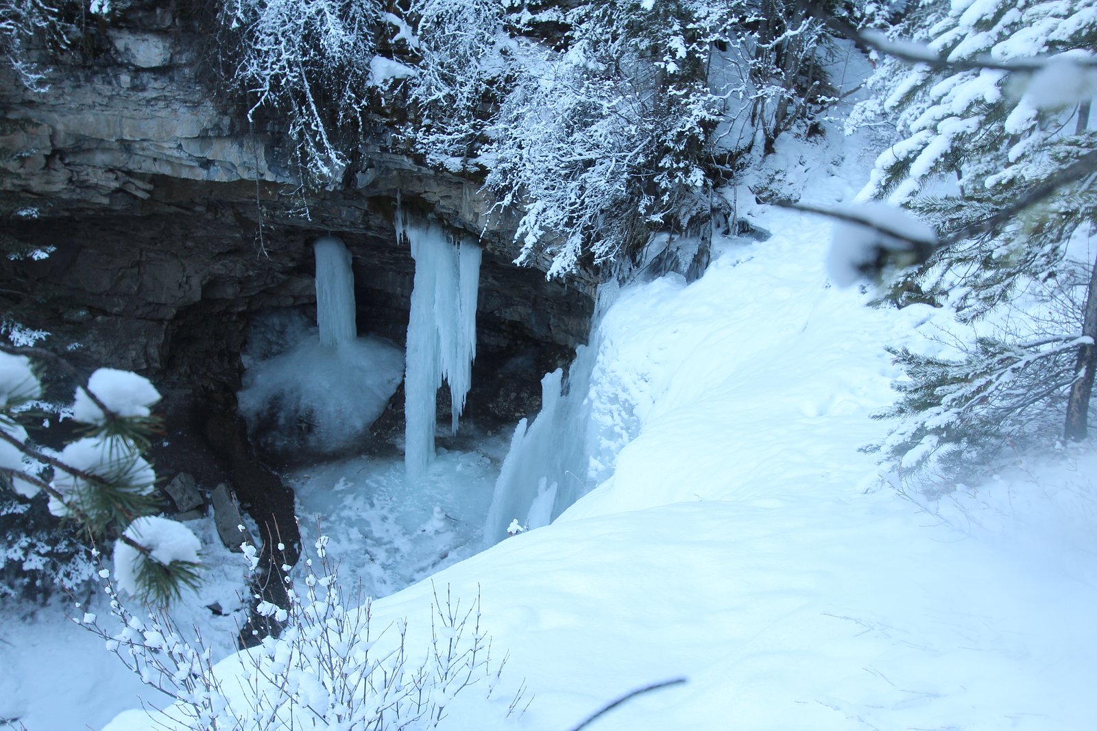
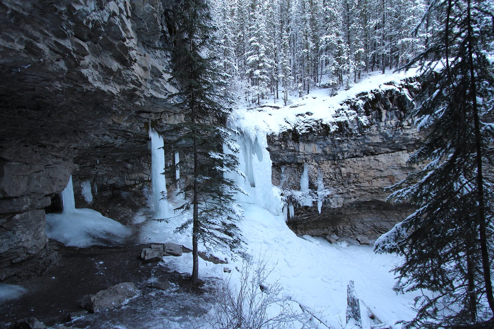
Cascade de glace is a named waterfall feature located in Alberta near the coordinates 50.8605, -115.0963. It sits in a mountainous, alpine/forested landscape typical of the eastern slopes of the Canadian Rockies. Public information about an established maintained trail, exact measured height, and official management unit for this specific cascade is limited. The feature is best described as a seasonal, mountain cascade that can be high and powerful during spring snowmelt and may form extensive ice in winter. Visitors should treat location details and access as approximate and verify with local authorities (Parks Canada, Alberta Parks, or local trail resources) before visiting.
The Setting
Cascade de glace sits at 1,699 metres within Elbow-Sheep Wildland Provincial Park, in the high mountains of Alberta.
Why This Waterfall Exists
Cascade de glace flows over hard intrusive rock laid down about 359-419 million years ago. These resistant rocks form a durable ledge that water cannot easily wear away, creating the falls where softer material downstream has already eroded.
Nearby Falls Worth Visiting
O'Shaughnessy Falls (7 m) lies 15.4 kilometres to the north.
Trail & Hike Details
The Approach
The moderate 6.9-km out-and-back trail gains 201 metres of elevation on the way to the falls.
Trail Description
There is not a well-documented, widely published maintained trail description for Cascade de glace available from major trail resources that can be confirmed here. Approaches to similar cascades in the region range from short scrambles visible from a nearby road or easy 0.5–2 mile hikes to longer, rougher off-trail routes requiring route-finding. Expect uneven terrain, possible stream crossings, and sections of loose rock or scree if approaching off-trail. If you find an established trailhead, follow cairns and flagged routes and consult recent trip reports for current conditions.
What to Expect
Expect a mountain cascade in a forested and rocky setting. Water flow will be highest during spring snowmelt and after heavy rain; summer flows may be lower. In winter the cascade may be partially or fully frozen and could form steep ice, this attracts ice climbers in some areas but is hazardous without the right skills and equipment. Cell coverage may be limited in remote mountain valleys. There are commonly no facilities, so carry everything you need and plan for self-rescue.
Accessibility
The trail is not wheelchair accessible. Uneven terrain and elevation changes require steady footing.
Frequently Asked Questions
🐶 Are Dogs Allowed at Cascade de glace?
❌ Dogs are not allowed
Are There Any Fees or Permits Required?
🆖 No fees required
🏊 Is There Swimming at Cascade de glace?
❌ Swimming is not allowed
When to Visit
Late spring through early fall (May–September) is typically best for easier access and strong water flow from snowmelt. Winter offers striking ice formations but requires technical skills and safety equipment. Shoulder seasons may have muddy or wet conditions; check weather and recent trip reports.
Seasonal Access
The best time to visit is Spring, Summer, Fall, and Winter. Check with the managing park or local authority for current conditions.
Safety Information
Hazards may include slippery rocks and wet approaches, fast-flowing water, cold temperatures, hypothermia risk, unstable or falling ice in winter, avalanche danger in seasonal zones, wildlife encounters (bears), and limited cell coverage and rescue response in remote areas. Always tell someone your plan and expected return time, carry appropriate safety gear, and avoid approaching the waterfall edge or standing on wet, unstable rocks. In winter or icy conditions, specialized equipment and winter experience are required, do not attempt technical ice climbs without proper training and gear.
Current Water Conditions
0.3 m³/s
Current discharge — how much water is flowing
About average for this time of year
Based on 48 years of record
0.37 m
Water depth at gauge
7-Day Discharge Trend
What does this mean for your visit?
Flow is about average for this time of year.
About This Gauge
This gauge is on a nearby waterway and may not reflect exact conditions at the falls.
7-Day Flow Outlook
Based on the WSC gauge JUMPINGPOUND CREEK NEAR COX HILL (19 km away).
Today
Moderate
0.2 m³/s
8/10Tomorrow
Moderate
0.3 m³/s
5/10Tue
Moderate
0.2 m³/s
5/10Wed
Moderate
0.2 m³/s
6/10Thu
Moderate
0.2 m³/s
5/10Fri
Moderate
0.2 m³/s
6/10Sat
Moderate
0.2 m³/s
8/10Best window: Today — moderate flow, sunny (trip score 8/10).
Best time of year: this gauge typically runs highest from mid May to late June, peaking in May.
How we calculate this
This is a transparent outlook, not a precise forecast. We take the waterfall's current flow strength (how it ranks against its historical normal for today, from the nearest WSC stream gauge), carry that ranking forward along the gauge's seasonal curve, and nudge it for forecast rain. Confidence is highest for the next day or two and falls further out. Always check official conditions and your own judgment before visiting — high flows can be dangerous.
Know when to go.
Get a free email alert when waterfalls near Banff hit peak flow. We only send when conditions are worth the trip — no weekly newsletters, no spam.
Weather Forecast
Location & Access
Getting There
Location: 50.8605, -115.0963. The site is roughly 35 miles from Banff, 54 miles from Calgary, and 74 miles from Lake Louise (as provided). Exact access routes vary; many cascades in this part of Alberta are reached via local logging/forest service roads or short off-trail approaches from nearby maintained trails. Visitors should use up-to-date maps and contact local land managers (Parks Canada if in Banff National Park, or Alberta Parks/Kananaskis if on provincial lands) to confirm access and whether the route crosses private land.
Get Directions on Google MapsParking
Parking availability is not confirmed for this specific feature. You may find small trailhead parking, pulloffs on secondary roads, or no formal parking depending on the access route. Do not park illegally; if a formal trailhead exists, use established parking areas only. Expect limited facilities (no toilets or services) unless the cascade is on a well-known maintained trail.
Elevation
1,699 metres above sea level
Coordinates
50.860482° N, -115.096344° W
Land Management
Managed by Parks Division, Alberta Forestry and Parks
Visitor Tips & Gear
1) Verify land management and access: contact Parks Canada, Alberta Parks, or local ranger stations to confirm the cascade is on public land and whether any restrictions exist. 2) Check recent trip reports and local trail resources (AllTrails, regional hiking guides) for up-to-date route and condition info. 3) Wear sturdy footwear with good traction; expect wet and slippery rocks. 4) In bear country: carry bear spray, make noise on approach, and know how to use spray; keep food stored securely. 5) Do not attempt to climb on or under unstable ice in winter; falling ice and collapse are real hazards. 6) Leave no trace: pack out all waste and avoid disturbing vegetation. 7) If uncertain of route-finding ability, go with a guide or someone familiar with the area.
This trail sits at 5,574 ft above sea level
Elevated TrailUV radiation is roughly 22% stronger at this elevation than at sea level, and the dry air accelerates dehydration. Extra sun protection and fluids go a long way.
As an Amazon Associate, we earn from qualifying purchases.

Coppertone Sport SPF 50 Sunscreen
UV intensity jumps ~4% per 1,000 ft — at this elevation you can burn in half the time.

Sun Bum SPF 30 Lip Balm (3-Pack)
Lips have almost no natural UV protection and burn fast in thin, dry mountain air.

Liquid I.V. Electrolyte Packets
You lose moisture ~2x faster at elevation — electrolytes help you absorb water efficiently.

ROCKNIGHT Polarized UV400 Sunglasses
High-altitude glare off rock and water is intense — UV400 lenses block 99%+ of UVA/UVB.
As an Amazon Associate, we earn from qualifying purchases.
With 6.9 km and 201 m of elevation gain, sturdy boots and trekking poles will help on this moderate trail. Icy conditions are common in winter — traction cleats are a smart addition.

Columbia Watertight II Rain Jacket
Packs into its own pocket, seam-sealed, and keeps you dry from spray and surprise rain.

Earth Pak Waterproof Dry Bag
Keeps your phone and gear dry when waterfall mist soaks everything else.

Waterproof Phone Pouch (AiRunTech)
Cheap insurance — take photos right next to the falls without killing your phone.

Timberland Euro Sprint Mid Waterproof
Trusted waterproof boot with premium leather and grippy rubber sole — reliable on rocky, wet trails.

TrailBuddy Trekking Poles
Lightweight aluminum, cork grips, and flip-locks that actually hold — a best-seller for good reason.

Kahtoola MICROspikes
Cult-favorite traction cleats that grip ice and wet rock — essential for winter waterfall hikes.
Where to Stay
Browse vacation cabins and private rentals nearby
Unique outdoor stays — tents, yurts, and treehouses
Rent a campervan or RV for your waterfall road trip
Some links are affiliate links. We may earn a commission at no extra cost to you.
Nearby Campground
Mount Kidd RV Park
4.7 km away
Additional Information
Nearby Attractions
Nearby regional attractions may include the town of Banff and Banff National Park, Canmore, Kananaskis Country, and various alpine lakes and hiking routes in the eastern Canadian Rockies. Confirm proximity and access before planning a combined visit.
Wildlife
Typical wildlife in the region includes black and grizzly bears, elk, deer, moose, mountain goats, bighorn sheep, wolves, and various small mammals and birds. Practice wildlife safety: keep distance, secure food, and carry bear spray where appropriate.
Cities near Cascade de glace
Nearby Waterfalls
Writing about Cascade de glace? Embed this waterfall on your site for free.