Difficulty
Moderate
Trail Length
1.0 km
Trail Type
Loop
Elevation Gain
41 m
About Black Hole Falls
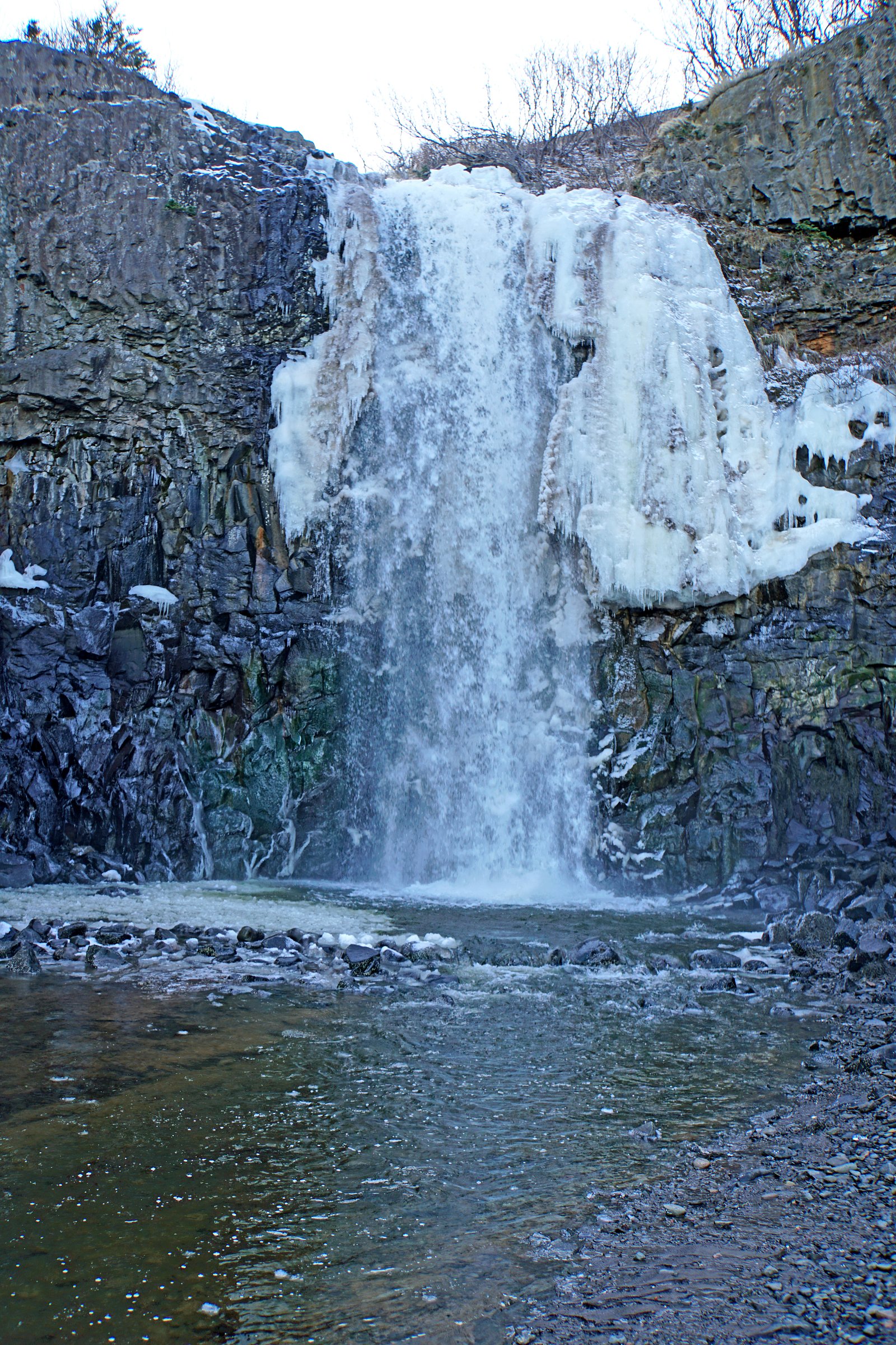
Black Hole Falls is a small, forested waterfall site in central Nova Scotia (approx. coordinates 45.234, -64.4933). The falls sit in a wooded river/gorge setting and are best known locally for a narrow plunge and a likely deep pool at the base (hence the name). Exact published trail details are limited; visitors report a short, informal approach from a local roadside access with natural rock and root steps down to the water. Expect variable flow by season, higher in spring and after heavy rain, lower in late summer. Access and facilities are minimal to non-existent; confirm current conditions and property access before visiting.
Why This Waterfall Exists
Black Hole Falls flows over hard volcanic rock laid down about 145-252 million years ago. These resistant rocks form a durable ledge that water cannot easily wear away, creating the falls where softer material downstream has already eroded.
Trail & Hike Details
The Approach
The moderate 1.0-km loop trail gains 41 metres of elevation on the way to the falls.
Trail Description
Publicly available information on an established maintained trail is limited. Reports indicate a short, natural-footpath approach through mixed forest that may descend steeply to the gorge and falls. The route may include muddy sections, roots, rocks and steep steps; there may be no handrails, boardwalks, or signage. Because the approach is likely informal and not heavily developed, expect uneven footing and the need to scramble in places to reach viewpoints or the base.
What to Expect
A small, scenic waterfall in a wooded gorge with moss-covered rocks and a plunge pool. Variable water volume: strongest in spring thaw and after rain. Minimal facilities, no restrooms, garbage bins, or lifeguards. Possible poor cellphone reception. Natural hazards such as slippery rocks, steep edges, and cold water. Wildlife common to Nova Scotia forests (birds, small mammals, occasional deer; black bears are present in the province but sightings near popular day-use areas are uncommon).
Accessibility
The trail is not wheelchair accessible. Uneven terrain and elevation changes require steady footing.
Frequently Asked Questions
🐶 Are Dogs Allowed at Black Hole Falls?
❌ Dogs are not allowed
Are There Any Fees or Permits Required?
🆖 No fees required
🏊 Is There Swimming at Black Hole Falls?
❌ Swimming is not allowed
When to Visit
Late spring (after snowmelt) and early to mid-spring rains produce the most impressive flow. Fall offers colorful foliage and generally cooler, less buggy conditions. Summer can be pleasant but flows may be lower. Winter access is possible but icy, with increased hazard from frozen surfaces, only attempt with appropriate winter gear and experience.
Seasonal Access
The best time to visit is Spring, Summer, Fall, and Winter. Check with the managing park or local authority for current conditions.
Safety Information
Primary hazards: slippery and unstable rock near the falls, steep drop-offs, cold and potentially fast-moving water, variable flow depending on season, poor or no guardrails, limited cellphone reception, and seasonal ice in winter. Check weather and recent visitor reports before visiting. Do not attempt technical climbs without proper experience and equipment. Treat the site as remote: tell someone your plans and expected return time.
Current Water Conditions
0.2 m³/s
Current discharge — how much water is flowing
About average for this time of year
Based on 25 years of record
0.44 m
Water depth at gauge
7-Day Discharge Trend
What does this mean for your visit?
Flow is about average for this time of year.
About This Gauge
This gauge is on a nearby waterway and may not reflect exact conditions at the falls.
7-Day Flow Outlook
Based on the WSC gauge NORTH BROOK AT SHEFFIELD MILLS (9 km away).
Today
Moderate
0.2 m³/s
5/10Tomorrow
Moderate
0.2 m³/s
6/10Tue
Moderate
0.2 m³/s
6/10Wed
Moderate
0.2 m³/s
5/10Thu
Moderate
0.2 m³/s
6/10Fri
Moderate
0.2 m³/s
6/10Sat
Moderate
0.2 m³/s
5/10Best window: Tomorrow — moderate flow, cloudy (trip score 6/10).
Best time of year: this gauge typically runs highest from early March to late April, peaking in April.
How we calculate this
This is a transparent outlook, not a precise forecast. We take the waterfall's current flow strength (how it ranks against its historical normal for today, from the nearest WSC stream gauge), carry that ranking forward along the gauge's seasonal curve, and nudge it for forecast rain. Confidence is highest for the next day or two and falls further out. Always check official conditions and your own judgment before visiting — high flows can be dangerous.
Know when to go.
Get a free email alert when waterfalls near Windsor hit peak flow. We only send when conditions are worth the trip — no weekly newsletters, no spam.
Weather Forecast
Location & Access
Getting There
The site is reached via local secondary roads off the main highways serving Windsor/Halifax area. GPS coordinates (45.234, -64.4933) are recommended for navigation. The trailhead and parking may be unmarked; follow any local signage and published trip reports. Roads to the immediate area can be narrow and may be seasonal.
Get Directions on Google MapsParking
Parking is likely informal: a small roadside pullout or a very small unpaved parking area. Spaces may be limited; park clear of driveways and do not block the road. Confirm property boundaries and any posted signs before leaving a vehicle.
Elevation
31 metres above sea level
Coordinates
45.234048° N, -64.493346° W
Visitor Tips & Gear
• Use GPS coordinates to find the access; trailhead may be unmarked. • Wear sturdy, grippy footwear; expect wet and slippery rock. • Bring water, a small first-aid kit, and a charged phone; do not rely on cell service. • Leave no trace: pack out all trash. • Stay back from cliff edges and avoid climbing on unstable rock near the falls. • Avoid entering the plunge pool unless you are sure of depth and hazards, currents and submerged rocks can be dangerous. • Check recent trip reports or local sources for access updates and private property notices.
As an Amazon Associate, we earn from qualifying purchases.
With 1.0 km and 41 m of elevation gain, sturdy boots and trekking poles will help on this moderate trail. Icy conditions are common in winter — traction cleats are a smart addition.

Columbia Watertight II Rain Jacket
Packs into its own pocket, seam-sealed, and keeps you dry from spray and surprise rain.

Earth Pak Waterproof Dry Bag
Keeps your phone and gear dry when waterfall mist soaks everything else.

Waterproof Phone Pouch (AiRunTech)
Cheap insurance — take photos right next to the falls without killing your phone.

Timberland Euro Sprint Mid Waterproof
Trusted waterproof boot with premium leather and grippy rubber sole — reliable on rocky, wet trails.

TrailBuddy Trekking Poles
Lightweight aluminum, cork grips, and flip-locks that actually hold — a best-seller for good reason.

Kahtoola MICROspikes
Cult-favorite traction cleats that grip ice and wet rock — essential for winter waterfall hikes.
Where to Stay
Browse vacation cabins and private rentals nearby
Unique outdoor stays — tents, yurts, and treehouses
Rent a campervan or RV for your waterfall road trip
Some links are affiliate links. We may earn a commission at no extra cost to you.
Nearby Campground
Look Off Family Camping Park
7.6 km away
Additional Information
Nearby Attractions
Nearby towns include Windsor and the broader Annapolis Valley / Hants County areas. The Bay of Fundy coast with its tides and coastal parks is within driving distance of the region; Halifax is the nearest major city for supplies and services. For current nearby attractions, consult local tourism resources.
Wildlife
Expect typical Nova Scotia woodland wildlife: songbirds, small mammals (squirrels, raccoons), white-tailed deer, amphibians and reptiles, and occasional black bear and moose in the region. Insect activity (black flies, mosquitoes, ticks) can be high in late spring and summer.
Cities near Black Hole Falls
Nearby Waterfalls
Writing about Black Hole Falls? Embed this waterfall on your site for free.