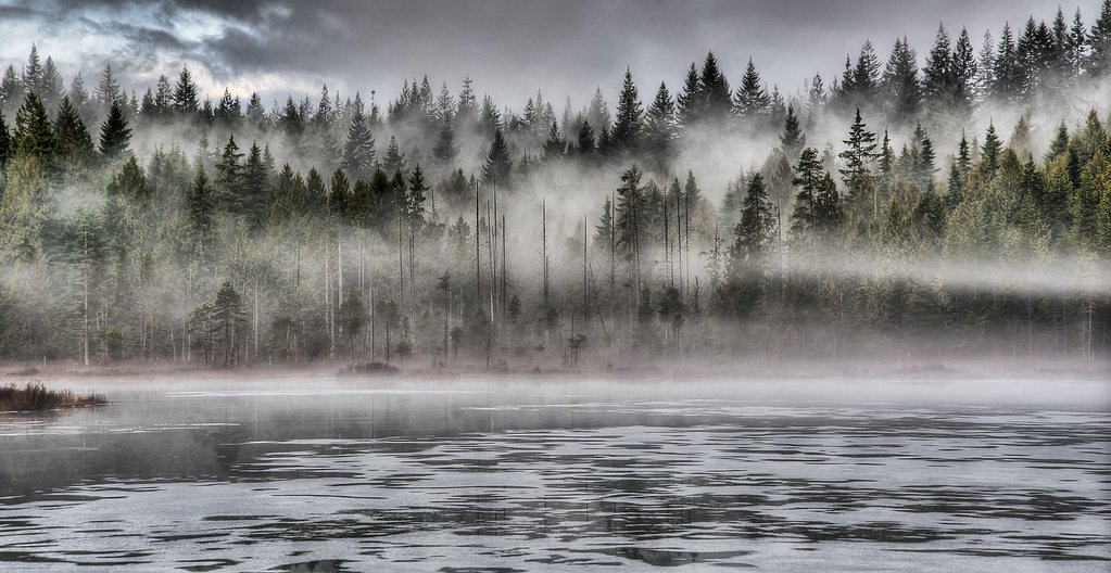
Anderson Creek Waterfalls
British Columbia • 1 m
By Armen Suny · Last verified Jun 2026
Difficulty
Moderate
About Anderson Creek Waterfalls
Anderson Creek Waterfalls is a small, forested creek cascade located on Anderson Creek near the Canada–US border in southern British Columbia (approximate coordinates 49.2564, -122.5842). The falls are in a mixed second-growth/forested valley and are best known to local hikers and creek walkers rather than as a developed tourist site. Flow and character are seasonal, highest in spring runoff and after heavy rain, lower in late summer. Specific published information (official park brochure or trail guide) is limited; visitors should treat the site as a lightly developed natural feature and plan accordingly.
The Setting
Anderson Creek Waterfalls sits at 30 metres in the coastal lowlands of British Columbia. The falls drop 1 metres.
Why This Waterfall Exists
Anderson Creek Waterfalls flows over hard intrusive rock laid down about 66-101 million years ago. These resistant rocks form a durable ledge that water cannot easily wear away, creating a 3-foot drop where softer material downstream has already eroded.
Nearby Falls Worth Visiting
Cliff Falls (9 m) lies 6.6 kilometres to the southeast. Also nearby: Goose Lake Falls (8 m, 4.7 km) and Mike Falls (5 m, 4.0 km).
Trail & Hike Details
Trail Description
Trail information is not well documented. Approaches are typically short but may be steep, overgrown, and cross uneven terrain. Expect singletrack or informal paths through forest with some brush, roots, and occasional muddy sections. Near the creek the route may require careful footing on rocks and wet ground. There may be no constructed boardwalks, railings, or maintained viewpoints.
What to Expect
The falls drop a gentle 1 metres over hard intrusive rock.
Accessibility
The trail is not wheelchair accessible. Uneven terrain and elevation changes require steady footing.
Frequently Asked Questions
🐶 Are Dogs Allowed at Anderson Creek Waterfalls?
❌ Dogs are not allowed
Are There Any Fees or Permits Required?
🆖 No fees required
🏊 Is There Swimming at Anderson Creek Waterfalls?
❌ Swimming is not allowed
When to Visit
Spring (high water) for strongest flows and more dramatic appearance. Late spring/early summer may offer a balance of flow and accessibility. Fall can be good for color and lower crowds. Winter visits are possible but may be icy, with hazardous footing, exercise extreme caution.
Seasonal Access
The best time to visit is Spring, Summer, and Fall. Winter access may be limited. Check with the managing park or local authority for current conditions.
Safety Information
Hazards may include slippery rocks and steep creek banks, variable water flow (flashy conditions after heavy rain), limited or no cell service, lack of formal trails or signage, and potential private property boundaries. If close to the international border, be mindful of crossing regulations, do not cross the border except at official ports of entry. Always tell someone your plan and expected return time.
Current Water Conditions
0.2 m³/s
Current discharge — how much water is flowing
Much lower than usual for this time of year
Based on 67 years of record
0.13 m
Water depth at gauge
7-Day Discharge Trend
What does this mean for your visit?
Flow is well below normal for this time of year, so the waterfall may be a trickle.
About This Gauge
7-Day Flow Outlook
Based on the WSC gauge NORTH ALOUETTE RIVER AT 232ND STREET, MAPLE RIDGE (2 km away).
Today
Barely Flowing
0.2 m³/s
5/10Tomorrow
Barely Flowing
0.2 m³/s
4/10Tue
Barely Flowing
0.2 m³/s
4/10Wed
Barely Flowing
0.2 m³/s
4/10Thu
Barely Flowing
0.2 m³/s
4/10Fri
Barely Flowing
0.1 m³/s
4/10Sat
Barely Flowing
0.1 m³/s
4/10Best window: Today — barely flowing flow, mainly sunny (trip score 5/10).
Best time of year: this gauge typically runs highest from early November to mid November, peaking in November.
How we calculate this
This is a transparent outlook, not a precise forecast. We take the waterfall's current flow strength (how it ranks against its historical normal for today, from the nearest WSC stream gauge), carry that ranking forward along the gauge's seasonal curve, and nudge it for forecast rain. Confidence is highest for the next day or two and falls further out. Always check official conditions and your own judgment before visiting — high flows can be dangerous.
Know when to go.
Get a free email alert when waterfalls near Abbotsford hit peak flow. We only send when conditions are worth the trip — no weekly newsletters, no spam.
Weather Forecast
Location & Access
Getting There
The falls are located near the Canada–US border, approximately 19–20 miles from the communities of Custer, Ferndale, and Blaine (Washington). Exact public access routes are not well-documented in major guidebooks; access is likely via local forest or rural roads and a short forest/creekside approach. Visitors should use the provided coordinates (49.2564, -122.5842) in a reliable mapping app, check local land ownership and access rules, and contact regional parks or local land managers if in doubt.
Get Directions on Google MapsParking
There is no confirmed formal parking lot for this waterfall. Expect limited roadside or informal parking; some spots may be on gravel roads or pullouts. Park legally and avoid blocking gates or driveways. Conditions may be muddy or uneven after rain.
Elevation
30 metres above sea level
Coordinates
49.256397° N, -122.584216° W
Visitor Tips & Gear
• Use the provided coordinates and verify land access before visiting. • Wear sturdy, waterproof footwear with good traction, rocks and roots are slippery. • Bring insect repellent in summer. • Park legally and leave gates as you found them. • Carry out all trash and avoid damaging vegetation or cliff edges. • Check recent local trail reports or contact regional parks/forest service for access updates. • Be aware of private property boundaries and do not cross fences without permission.
Where to Stay
Browse vacation cabins and private rentals nearby
Unique outdoor stays — tents, yurts, and treehouses
Rent a campervan or RV for your waterfall road trip
Some links are affiliate links. We may earn a commission at no extra cost to you.
Nearby Campground
Edgewater Bar Campground
5.7 km away
Nearby Hot Springs
Hot springs near Abbotsford, British Columbia
Dorr Fumarole Field
Dorr Fumarole Field reaches 194 degrees at 8,168 feet elevation on Mount Baker's active volcanic slopes, producing superheated ...

Sherman Crater Fumaroles
Sherman Crater Fumaroles register 266 degrees Fahrenheit at 9,463 feet elevation within the active volcanic crater atop Mount B...
Baker Hot Spring
Baker Hot Spring emerges at 108 degrees Fahrenheit on US Forest Service land in Mt. Baker National Forest, flowing 59.5 degrees...
Looking for a soak after your hike? Explore more hot springs near Abbotsford, British Columbia on SoakingSprings.
Explore British Columbia springsAdditional Information
Nearby Attractions
The site is near the Canada–US border and within driving distance of small communities on both sides. There are regional parks and trails in the Fraser Valley and nearby areas; check local tourism resources for nearby established parks and viewpoints.
Wildlife
Typical southern British Columbia lowland wildlife may be present: deer, small mammals, waterfowl, and many bird species. Black bears and cougars exist in the region; exercise normal wildlife awareness (store food, keep distance). Ticks and biting insects may be present in warm months.
Cities near Anderson Creek Waterfalls
Nearby Waterfalls
Writing about Anderson Creek Waterfalls? Embed this waterfall on your site for free.