Ammonite Falls
British Columbia • 20 m
By Armen Suny · Last verified Jun 2026
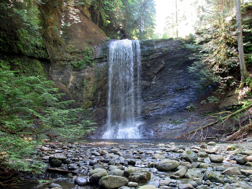
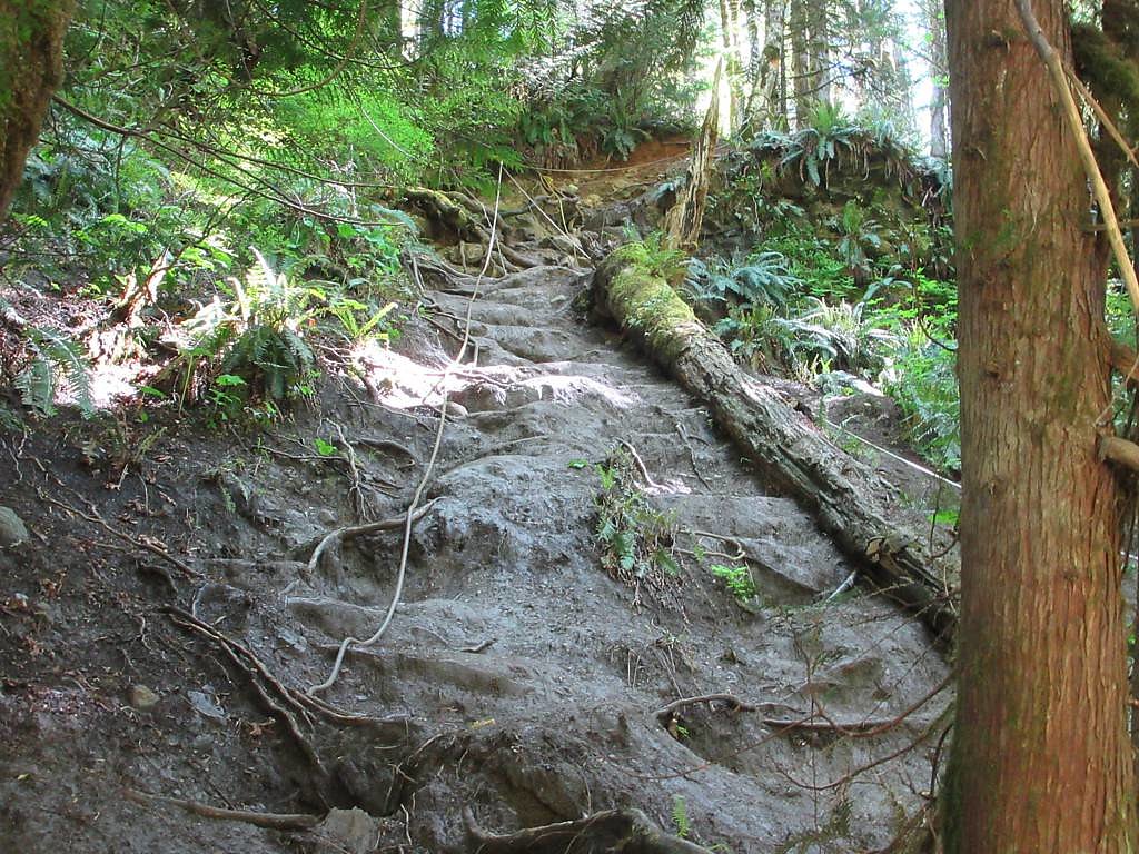
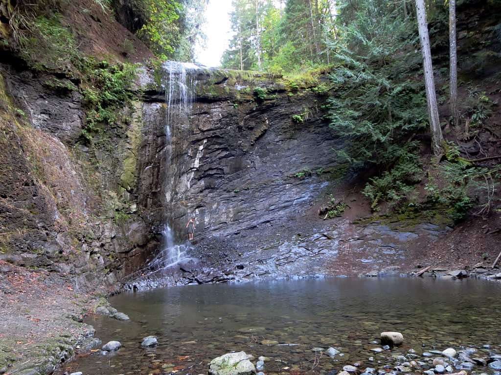
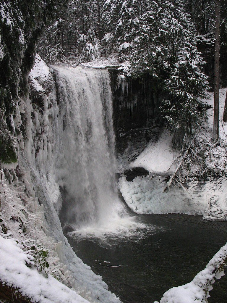

Photo Credits (5)
Difficulty
Moderate
Trail Length
4.8 km
Trail Type
Out And Back
Elevation Gain
203 m
About Ammonite Falls
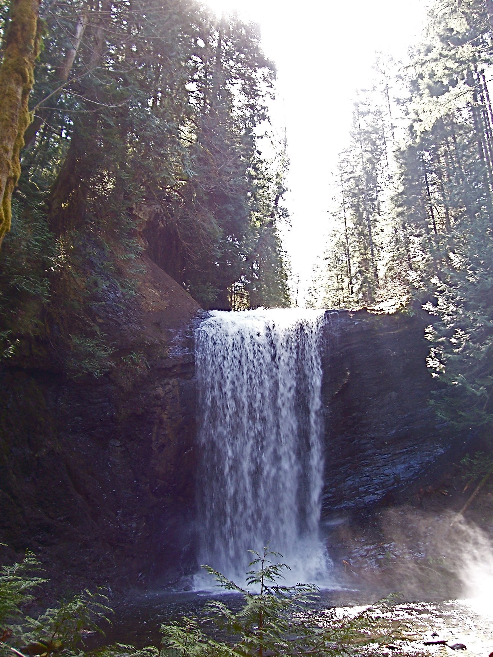
Ammonite Falls is a forested, likely small-to-moderate cascade on southern Vancouver Island near Nanaimo (coordinates 49.19, -124.0792). Public information about this specific named fall is limited; visitors report a wooded approach and variable flow with higher water in spring and after heavy rain. Exact height and official trail details are not well documented and may vary by source.
The Setting
Ammonite Falls sits at 228 metres in the foothills of British Columbia. The falls drop 20 metres.
Why This Waterfall Exists
Ammonite Falls flows over Nanaimo Group, a layered sedimentary rock layer deposited about 66-101 million years ago. Over time, the stream has worn through these layers at different rates, creating a 66-foot drop that forms the waterfall.
Nearby Falls Worth Visiting
Knarston Waterfall (12 m) lies 6.0 kilometres to the northwest.
Trail & Hike Details
The Approach
The moderate 4.8-km out-and-back trail gains 203 metres of elevation on the way to the falls.
Trail Description
Detailed, authoritative trail descriptions for Ammonite Falls are scarce. Reports suggest a forested approach that may follow a single-track or informal path to viewpoints. Trails may be muddy and rooty, with potential short steep or slippery sections near the waterfall. There may be no developed boardwalks, railings, or formal viewing platforms.
What to Expect
The falls drop 20 metres over layered sedimentary rock.
Accessibility
The trail is not wheelchair accessible. Uneven terrain and elevation changes require steady footing.
Frequently Asked Questions
🐶 Are Dogs Allowed at Ammonite Falls?
❌ Dogs are not allowed
Are There Any Fees or Permits Required?
🆖 No fees required
🏊 Is There Swimming at Ammonite Falls?
❌ Swimming is not allowed
When to Visit
Spring (snowmelt and rainy season) for strongest flows; late spring and early summer for a balance of flow and more stable weather. Fall can be scenic with foliage. Winter visits are possible but expect icy, muddy, and potentially hazardous conditions, exercise caution.
Seasonal Access
The best time to visit is Spring, Summer, Fall, and Winter. Check with the managing park or local authority for current conditions.
Safety Information
Hazards may include slippery rocks and trails, steep or loose terrain near the water, high flows after rain, cold water temperatures, limited cell service, and potential wildlife encounters. Do not climb on wet cliffs or swim near strong currents. Check weather and trail conditions before visiting and err on the side of caution. If trail or access crosses private land, respect closures and posted warnings.
Current Water Conditions
0.1 m³/s
Current discharge — how much water is flowing
About average for this time of year
Based on 41 years of record
1.17 m
Water depth at gauge
7-Day Discharge Trend
What does this mean for your visit?
Flow is about average for this time of year.
About This Gauge
This gauge is on a nearby waterway and may not reflect exact conditions at the falls.
7-Day Flow Outlook
Based on the WSC gauge MILLSTONE RIVER AT NANAIMO (8 km away).
Today
Moderate
0.1 m³/s
8/10Tomorrow
Moderate
0.1 m³/s
6/10Tue
Moderate
0.0 m³/s
6/10Wed
Moderate
0.1 m³/s
6/10Thu
Moderate
0.0 m³/s
5/10Fri
Moderate
0.0 m³/s
6/10Sat
Moderate
0.0 m³/s
5/10Best window: Today — moderate flow, sunny (trip score 8/10).
Best time of year: this gauge typically runs highest from mid November to late January, peaking in January.
How we calculate this
This is a transparent outlook, not a precise forecast. We take the waterfall's current flow strength (how it ranks against its historical normal for today, from the nearest WSC stream gauge), carry that ranking forward along the gauge's seasonal curve, and nudge it for forecast rain. Confidence is highest for the next day or two and falls further out. Always check official conditions and your own judgment before visiting — high flows can be dangerous.
Know when to go.
Get a free email alert when waterfalls near Nanaimo hit peak flow. We only send when conditions are worth the trip — no weekly newsletters, no spam.
Weather Forecast
Location & Access
Getting There
Located on Vancouver Island near Nanaimo. Use the provided coordinates (49.19, -124.0792) with a reliable mapping app to navigate to the nearest trailhead or parking area. Local logging roads or secondary roads may be involved; expect unpaved access in some areas. Verify recent access conditions before traveling.
Get Directions on Google MapsParking
Parking information is not well documented. Expect limited roadside or small informal parking at a trailhead. Park legally and avoid blocking gates or private driveways. If unsure, check with local land managers or recreation websites before visiting.
Elevation
228 metres above sea level
Coordinates
49.189977° N, -124.079177° W
Visitor Tips & Gear
1) Wear sturdy, waterproof hiking shoes with good traction, rocks near the falls will be slippery. 2) Bring layers and rain protection; the area is moist and weather can change quickly. 3) Travel with a partner when exploring non-developed trails and tell someone your route. 4) Leave no trace: pack out all trash and avoid disturbing vegetation or geological features. 5) Confirm access and parking with local resources before visiting in case of private property or logging activity.
As an Amazon Associate, we earn from qualifying purchases.
With 4.8 km and 203 m of elevation gain, sturdy boots and trekking poles will help on this moderate trail. Icy conditions are common in winter — traction cleats are a smart addition.

Columbia Watertight II Rain Jacket
Packs into its own pocket, seam-sealed, and keeps you dry from spray and surprise rain.

Polarized Sunglasses (Knockaround)
Cuts glare off the water so you actually see the falls — and your photos turn out better too.

Earth Pak Waterproof Dry Bag
Keeps your phone and gear dry when waterfall mist soaks everything else.

Waterproof Phone Pouch (AiRunTech)
Cheap insurance — take photos right next to the falls without killing your phone.

Timberland Euro Sprint Mid Waterproof
Trusted waterproof boot with premium leather and grippy rubber sole — reliable on rocky, wet trails.

TrailBuddy Trekking Poles
Lightweight aluminum, cork grips, and flip-locks that actually hold — a best-seller for good reason.
Where to Stay
Browse vacation cabins and private rentals nearby
Unique outdoor stays — tents, yurts, and treehouses
Rent a campervan or RV for your waterfall road trip
Some links are affiliate links. We may earn a commission at no extra cost to you.
Nearby Campground
Brannen Lake RV Park & Campsite
1.8 km away
Additional Information
Nearby Attractions
The falls are on southern Vancouver Island near Nanaimo. Nearby attractions on the island include beaches, coastal parks, and hiking areas around Nanaimo and Vancouver Island more broadly. For specific nearby parks or paid facilities, consult local recreation resources or tourism guides for the Nanaimo area.
Wildlife
Typical Vancouver Island wildlife may be present: black bears, black-tailed deer, cougars (rare), bald eagles, and a variety of small mammals and birds. Maintain distance from wildlife and store food securely.
Cities near Ammonite Falls
Nearby Waterfalls
Writing about Ammonite Falls? Embed this waterfall on your site for free.