
Photo Credits (5)
Difficulty
Easy
Trail Length
0.9 miles
Trail Type
Out And Back
Elevation Gain
200 ft
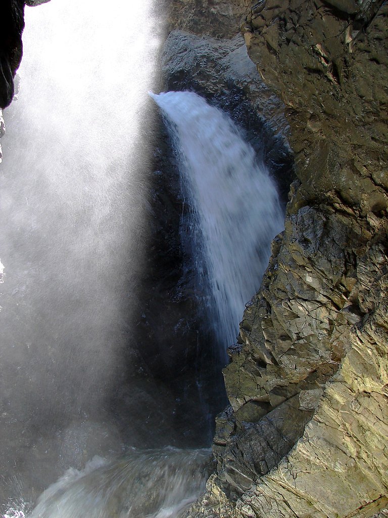
About Zapata Falls
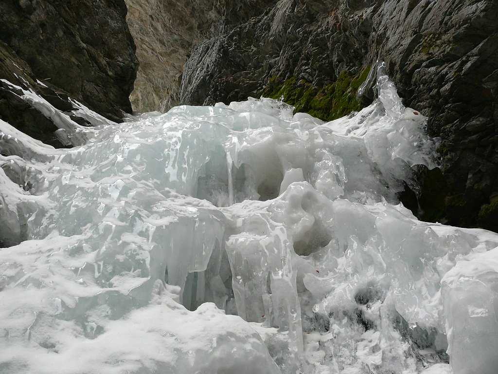
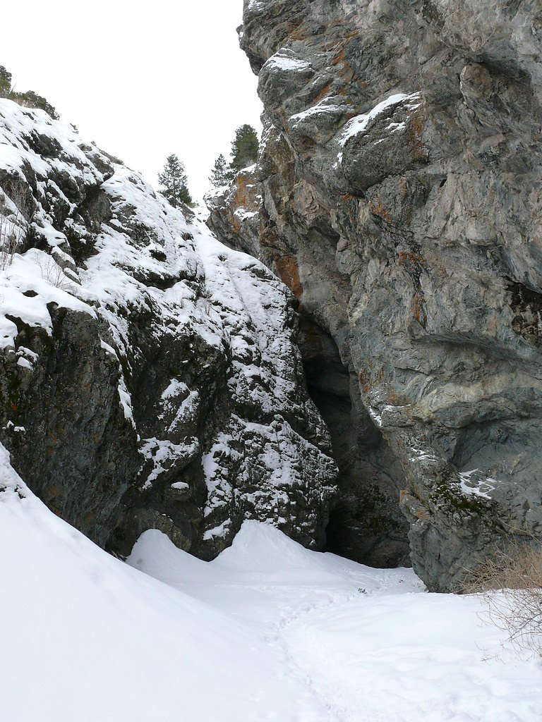
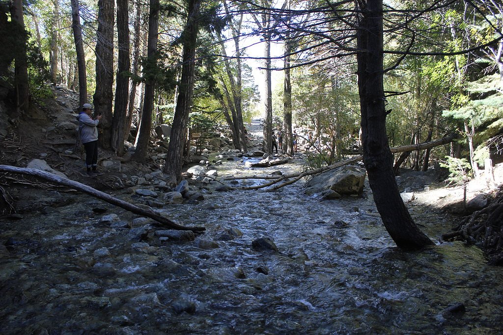
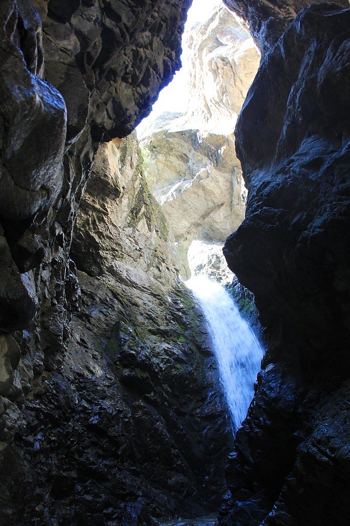
Tucked into a narrow rocky cleft at the base of the Sangre de Cristo Mountains in Colorado’s San Luis Valley, Zapata Falls is a striking, secluded cascade dropping roughly 25–30 feet (about 7.5–9 m). The falls sit just south of Great Sand Dunes National Park and Preserve in Alamosa County, and sources note the site lies amid a patchwork of public lands — described in some accounts as Bureau of Land Management territory and in others as Zapata Falls State Trust Lands overseen as an SRMA by SFW. The approach and the carved rock alcove give Zapata Falls a dramatic, intimate feel that rewards the short effort required to reach it. The hike to the viewing area is short but lively, and the final few yards require wading across a shallow stream and scrambling over rocks to see the falls up close — in winter those rocks and the pool can be icy. For campers, Zapata Falls Campground is about 3.85 km away, making this a convenient half-day excursion when paired with a night under the stars near the dunes and the mountains.
The Setting
Zapata Falls sits at 9,436 feet within Zapata Falls State Trust Lands, in the high alpine of Colorado. The falls drop 25 feet.
Height: 25 feet
Trail & Hike Details
The Approach
The easy 0.9-mile out-and-back trail gains 200 feet of elevation on the way to the falls.
Trail Description
This out-and-back route is a short, mildly steep trek of about 0.5 miles one-way (approximately 0.9 miles round trip) with roughly 200 feet of elevation gain. Rated easy, the trail is well used and gains elevation steadily before dropping into the rocky streambed that feeds the falls. The ultimate approach requires fording the stream and climbing over rocks to reach the viewing crevasse; expect wet and possibly icy conditions in colder months and wear sturdy, water-resistant footwear. No USFS trail number or detailed USFS surface/grade/class data is provided in the available sources.
What to Expect
The falls drop a gentle 25 feet. Dogs are welcome.
Accessibility
The trail is not wheelchair accessible. Uneven terrain and elevation changes require steady footing.
Frequently Asked Questions
🐶 Are Dogs Allowed at Zapata Falls?
✅ Dogs are allowed
Are There Any Fees or Permits Required?
🤑 Fee: $11.00
🏊 Is There Swimming at Zapata Falls?
❌ Swimming is not allowed
When to Visit
Summer and early fall are the best times to visit for easy access and strong water flow. Winter offers a unique experience with frozen falls but requires extra caution.
Seasonal Access
The best time to visit is Spring, Summer, Fall, and Winter.
Safety Information
The streambed can be slippery, especially in winter when ice forms. Use caution and proper footwear. Be prepared for sudden weather changes, as the area can be windy and cold.
Know when to go.
Get a free email alert when waterfalls near Blanca hit peak flow. We only send when conditions are worth the trip — no weekly newsletters, no spam.
Weather Forecast
Location & Access
Getting There
Zapata Falls is located off Highway 150, about 3 miles south of the entrance to Great Sand Dunes National Park. A 3-mile gravel road leads to the parking area, which is accessible by most vehicles, though it may be rough for low-clearance cars.
Get Directions on Google MapsParking
There is a designated parking area at the trailhead, which can accommodate a moderate number of vehicles. It may fill up during peak seasons.
Elevation
9,436 feet above sea level
Coordinates
37.619027° N, -105.553156° W
Land Management
Managed by SFW
Visitor Tips & Gear
Arrive early during peak seasons to secure parking. Wear sturdy, waterproof footwear, as you will need to walk through water or icy conditions to see the falls. Bring a flashlight if visiting in low light, as the crevasse can be dark.
This trail sits at 9,436 ft — the air is noticeably thinner
High AltitudeSome visitors experience headaches, fatigue, or shortness of breath at this elevation. Take it slow, stay hydrated, and consider supplemental oxygen if you're coming from a lower altitude.
As an Amazon Associate, we earn from qualifying purchases.

Coppertone Sport SPF 50 Sunscreen
UV intensity jumps ~4% per 1,000 ft — at this elevation you can burn in half the time.

Sun Bum SPF 30 Lip Balm (3-Pack)
Lips have almost no natural UV protection and burn fast in thin, dry mountain air.

Liquid I.V. Electrolyte Packets
You lose moisture ~2x faster at elevation — electrolytes help you absorb water efficiently.

ROCKNIGHT Polarized UV400 Sunglasses
High-altitude glare off rock and water is intense — UV400 lenses block 99%+ of UVA/UVB.

Boost Oxygen 10L Canister (2-Pack)
Portable supplemental oxygen for quick relief from headaches and shortness of breath.

Altitude Rx OxyBoost Complex
Antioxidant formula designed to support your body's natural altitude acclimation.
As an Amazon Associate, we earn from qualifying purchases.
For this easy 0.9 miles trail, lightweight trail shoes and a water bottle are usually sufficient. Icy conditions are common in winter — traction cleats are a smart addition.

Columbia Watertight II Rain Jacket
Packs into its own pocket, seam-sealed, and keeps you dry from spray and surprise rain.

Polarized Sunglasses (Knockaround)
Cuts glare off the water so you actually see the falls — and your photos turn out better too.

Earth Pak Waterproof Dry Bag
Keeps your phone and gear dry when waterfall mist soaks everything else.

Waterproof Phone Pouch (AiRunTech)
Cheap insurance — take photos right next to the falls without killing your phone.

Kahtoola MICROspikes
Cult-favorite traction cleats that grip ice and wet rock — essential for winter waterfall hikes.

JOBY GorillaPod Starter Kit
Wraps around railings and rocks for long-exposure waterfall shots — no flat surface needed.
Where to Stay

Great Sand Dunes Lodge

Holiday Inn Express & Suites Alamosa by IHG

Comfort Inn & Suites Alamosa

Base Camp Ranch House
Browse vacation cabins and private rentals nearby
Unique outdoor stays — tents, yurts, and treehouses
Rent a campervan or RV for your waterfall road trip
Some links are affiliate links. We may earn a commission at no extra cost to you.
Nearby Campground
Zapata Falls Campground
2.4 miles away · 32 sites
Overview A short drive up the gravel road that leads to the Bureau of Land Management’s Zapata Falls Campground (CG) will let visitors to the area see the San Luis Valley and Great Sand Dunes National Park & Preserve from a whole new perspective. The campground offers bird’s-eye views of the valley floor below, the San Juan Mountains to the west, the adjacent Great Sand Dunes National Park and Preserve, and several 14er’s and many other towering peaks of the Sangre de Cristo Mountain range that Z
Book on Recreation.govNearby Hot Springs
Hot springs near Blanca, Colorado
Splashland Hot Springs
Splashland Hot Springs reaches 40.5 degrees Celsius (105 degrees Fahrenheit) at just 13 meters from a gravel road near Alamosa ...
Sand Dunes Pool
Sand Dunes Pool sits at 7,539 feet in Colorado's San Luis Valley, just eight meters from a gravel road. At this remote, high-el...
Dexter Spring
Dexter Spring flows at a gentle 68 degrees Fahrenheit in Alamosa County's high valley terrain, offering modest thermal characte...

Shaw Springs
Shaw Springs emerges at 86 degrees Fahrenheit where Rio Grande County's high plateau meets the San Juan Mountains. At 7,971 fee...

Valley View Hot Springs
Valley View Hot Springs flows at 99 degrees Fahrenheit from the eastern slopes of the Sangre de Cristo Range at 8,850 feet elev...

Mineral Hot Springs
Mineral Hot Springs emerges at 140°F in Saguache County at 7,744 feet elevation in the northern San Luis Valley, where thermal ...
Looking for a soak after your hike? Explore more hot springs near Blanca, Colorado on SoakingSprings.
Explore Colorado springsAdditional Information
Nearby Attractions
Great Sand Dunes National Park, San Luis Valley, Blanca Peak
Wildlife
The area is home to various wildlife, including deer, birds, and small mammals. Be cautious of snakes in warmer months.
Cities near Zapata Falls
Writing about Zapata Falls? Embed this waterfall on your site for free.