Difficulty
Moderate
Trail Length
2.4 miles
Trail Type
Out And Back
Elevation Gain
350 ft
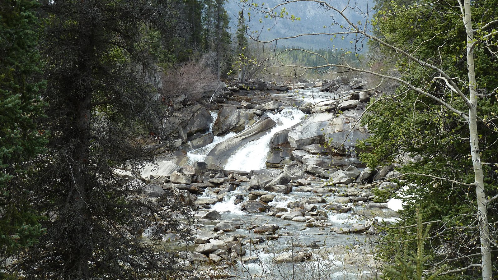
About Wyandotte Falls
Wyandotte Falls is a small, picturesque cascade on the Indian River in Michigan's Upper Peninsula, tucked into the mixed hardwoods of the Baraga State Forest Area. The site is owned and managed by the State Department of Natural Resources (SDNR) and carries an SCA designation, which helps preserve the site's quiet, natural character. That protected setting makes Wyandotte Falls a peaceful alternative to busier waterfall stops in the region. The approach offers leafy river views and a serene, forested atmosphere—perfect for hikers, photographers, and anyone seeking a short escape into nature. Facilities are minimal under SDNR management, so expect a rustic, undeveloped experience; come prepared for uneven ground and the possibility of muddy sections after rain.
The Setting
Wyandotte Falls sits at 1,152 feet within Baraga State Forest Area, fed by the Sturgeon River, in the foothills of Michigan.
Trail & Hike Details
The Approach
The moderate 2.4-mile out-and-back trail gains 350 feet of elevation on the way to the falls.
Trail Description
This is an out-and-back route totaling about 2.4 miles with roughly 350 feet of elevation gain and is typically rated moderate. The path is a natural forest footpath with well-shaded sections along the river; while much of the grade is gentle, short uphill stretches create the listed elevation gain. Tread can become muddy after wet weather, so sturdy footwear is recommended. No USFS trail number or surface/grade classification is provided for this SDNR-managed route.
What to Expect
Dogs are welcome.
Accessibility
The trail is not wheelchair accessible. Uneven terrain and elevation changes require steady footing.
Frequently Asked Questions
🐶 Are Dogs Allowed at Wyandotte Falls?
✅ Dogs are allowed
Are There Any Fees or Permits Required?
🆖 No fees required
🏊 Is There Swimming at Wyandotte Falls?
❌ Swimming is not allowed
When to Visit
Spring and early summer are ideal times to visit, as water flow is typically higher due to snowmelt and rainfall.
Seasonal Access
The best time to visit is Spring, Summer, and Fall. Winter access may be limited.
Safety Information
Visitors should exercise caution on wet or muddy trails to avoid slipping. Be aware of wildlife and carry bug spray to deter mosquitoes and ticks. Cell service may be limited in the area, so plan accordingly.
Current Water Conditions
Based on a USGS gauge 15.3 miles away
341 ft³/s
Current discharge — how much water is flowing
About average for this time of year
Based on 93 years of record
4.56 ft
Water depth at gauge
64°F
CoolRefreshing for swimming
7-Day Discharge Trend
What does this mean for your visit?
Flow is about average for this time of year. Water temperature is a refreshing 64 degrees F, good for a quick swim.
About This Gauge
This gauge is on a regional waterway. Conditions at the falls may differ, especially after local rain.
7-Day Flow Outlook
Based on the USGS gauge STURGEON RIVER NEAR ALSTON, MI (25 km away).
Today
Barely Flowing
341 cfs
5/10Tomorrow
Barely Flowing
349 cfs
3/10Mon
Low
410 cfs
3/10Tue
Low
431 cfs
3/10Wed
Low
416 cfs
3/10Thu
Low
410 cfs
3/10Fri
Low
414 cfs
3/10Best window: Today — barely flowing flow, sunny (trip score 5/10).
Best time of year: this gauge typically runs highest from late March to mid June, peaking in April.
How we calculate this
This is a transparent outlook, not a precise forecast. We take the waterfall's current flow strength (how it ranks against its historical normal for today, from the nearest USGS stream gauge), carry that ranking forward along the gauge's seasonal curve, and nudge it for forecast rain. Confidence is highest for the next day or two and falls further out. Always check official conditions and your own judgment before visiting — high flows can be dangerous.
Know when to go.
Get a free email alert when waterfalls near Pelkie hit peak flow. We only send when conditions are worth the trip — no weekly newsletters, no spam.
Weather Forecast
Location & Access
Getting There
Wyandotte Falls is located near the Indian River in the Hiawatha National Forest. Access is typically via forest roads, which may require a high-clearance vehicle depending on conditions. Visitors should check local maps or consult the Hiawatha National Forest office for the most accurate directions.
Get Directions on Google MapsParking
Parking is available near the trailhead, but spaces may be limited. Visitors should be prepared for unpaved or uneven parking areas.
Elevation
1,152 feet above sea level
Coordinates
46.890278° N, -88.878889° W
Land Management
Managed by SDNR
Visitor Tips & Gear
Bring bug spray during the summer months, as mosquitoes can be prevalent. Wear sturdy shoes, especially after rain, as the trail may be slippery. Check road conditions before visiting, as forest roads can be rough or muddy.
As an Amazon Associate, we earn from qualifying purchases.
With 2.4 miles and 350 ft of elevation gain, sturdy boots and trekking poles will help on this moderate trail. Sun exposure on the trail makes good sun protection a must in summer.

Columbia Watertight II Rain Jacket
Packs into its own pocket, seam-sealed, and keeps you dry from spray and surprise rain.

Earth Pak Waterproof Dry Bag
Keeps your phone and gear dry when waterfall mist soaks everything else.

Waterproof Phone Pouch (AiRunTech)
Cheap insurance — take photos right next to the falls without killing your phone.

Timberland Euro Sprint Mid Waterproof
Trusted waterproof boot with premium leather and grippy rubber sole — reliable on rocky, wet trails.

TrailBuddy Trekking Poles
Lightweight aluminum, cork grips, and flip-locks that actually hold — a best-seller for good reason.

Polarized Sunglasses (Knockaround)
Cuts glare off the water so you actually see the falls — and your photos turn out better too.
Where to Stay

Trailside Furnished Apartment

Independence Stay Hotel and Long term suites

AC4 Northwoods Getaway w Jetted Tub

Jake's Bed & Bar
Browse vacation cabins and private rentals nearby
Unique outdoor stays — tents, yurts, and treehouses
Rent a campervan or RV for your waterfall road trip
Some links are affiliate links. We may earn a commission at no extra cost to you.
Nearby Campground
Ontonagon Ranger District
20.6 miles away · 0 sites
Ontonagon Ranger District is on the shores of Lake Superior, largest of the Great Lakes, and the mouth of the Ontonagon River. There are numerous outdoor recreational opportunities. Hunting, fishing, swimming, hiking, boating, and ATV riding are available in the summer and fall months. In the winter downhill, cross-country skiing, snowmobiling and snowshoeing are available.
Book on Recreation.govAdditional Information
Nearby Attractions
Other waterfalls in the Hiawatha National Forest, such as Wagner Falls and Munising Falls, are within driving distance. The Pictured Rocks National Lakeshore is also a popular destination nearby.
Wildlife
The area is home to a variety of wildlife, including deer, birds, and small mammals. Visitors should be cautious of ticks and other insects.
Cities near Wyandotte Falls
Nearby Waterfalls
Writing about Wyandotte Falls? Embed this waterfall on your site for free.