Photo Credits (5)
Difficulty
Moderate
Trail Length
2.4 miles
Trail Type
Out And Back
Elevation Gain
350 ft
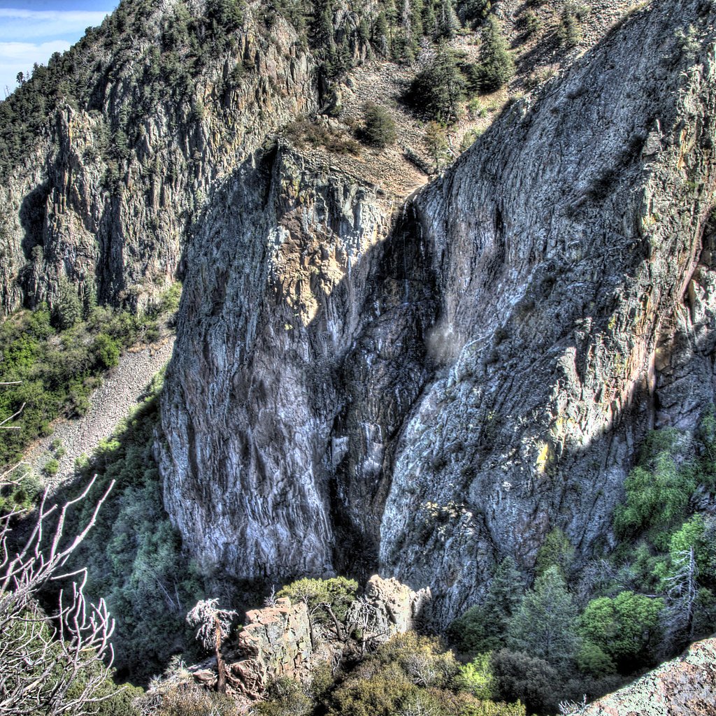
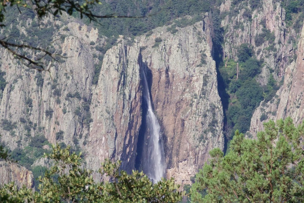
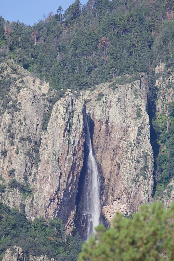
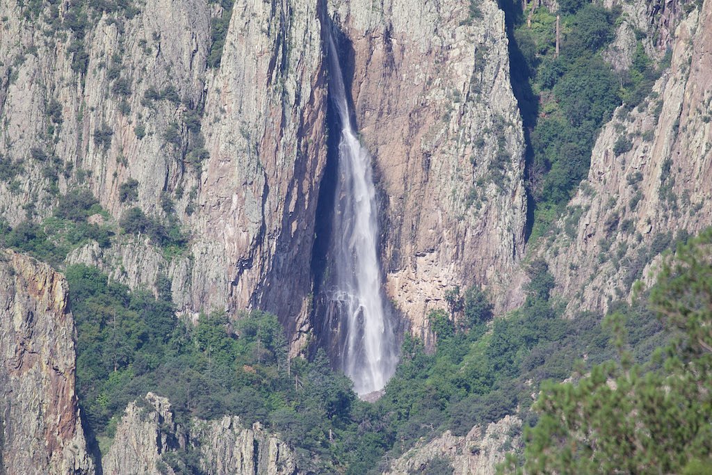
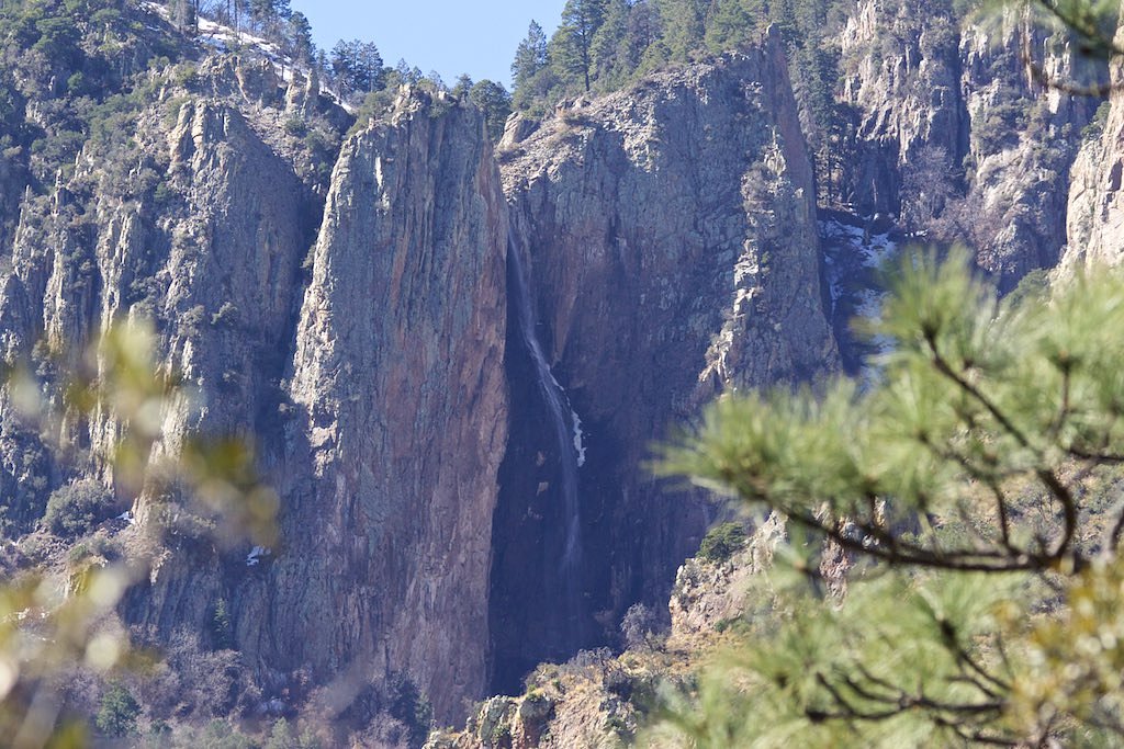
About Winn Falls
Winn Falls tumbles roughly 400 feet down a rugged cliff in the Chiricahua Mountains, tucked within the Coronado National Forest and managed by the U.S. Forest Service. This striking cascade is seasonal — most impressive after monsoon storms or spring snowmelt — and sits in a remote, volcanic-rock landscape characteristic of the range. The setting feels wild and solitary, framed by steep canyon walls and high-desert forest. Access is from the Herb Martyr Trailhead via the USFS Booger Spring route (Trail #347). The complete outing is a 2.4-mile out-and-back with about 350 feet of elevation gain and a moderate difficulty rating. Plan to visit after rains for the best flow, wear sturdy footwear for rocky, uneven ground, and expect limited services in this backcountry area.
The Setting
Winn Falls sits at 7,398 feet within Coronado National Forest, in the high mountains of Arizona. At 400 feet, it is among the taller waterfalls in Arizona.
Height: 400 feet
Trail & Hike Details
The Approach
The moderate hike follows Booger Spring (#347), a 2.4-mile out-and-back trail over natural surface. Expect 350 feet of elevation gain with grades of +8-10%. The trail is developed (Class 3).
USFS Trail
BOOGER SPRING #347
Trail Class
Developed
Surface
Avg Grade
USFS Segment
0.19 miTrail Description
Trail begins at the Herb Martyr Trailhead and follows the route that includes the USFS Booger Spring (Trail #347). The full approach to Winn Falls is a 2.4-mile out-and-back with approximately 350 feet of cumulative elevation gain and a moderate difficulty rating. USFS data shows a mapped GIS segment of 0.19 miles for Booger Spring Trail #347; that segment is classified as Class 3 with a native-material surface and a typical grade of +8–10%. Hikers should expect rocky, uneven tread, brief scrambling or steeper sections, and a few stream crossings as the trail threads through forested slopes and canyon terrain.
What to Expect
The falls plunge a dramatic 400 feet. Dogs are welcome.
Accessibility
The trail is not wheelchair accessible. Uneven terrain and elevation changes require steady footing.
Frequently Asked Questions
🐶 Are Dogs Allowed at Winn Falls?
✅ Dogs are allowed
Are There Any Fees or Permits Required?
🆖 No fees required
🏊 Is There Swimming at Winn Falls?
❌ Swimming is not allowed
When to Visit
The best time to visit Winn Falls is in the spring or early summer when the waterfall is most likely to be flowing. Fall is also a great time for cooler temperatures and colorful foliage.
Seasonal Access
The best time to visit is Spring, Summer, and Fall. Access roads and trails may close during winter due to snow. Watch for flash flood warnings during monsoon season (July through September). Check with Coronado National Forest for seasonal road closures.
Safety Information
Be cautious of flash floods during monsoon season and watch for wildlife, including snakes. Carry a first aid kit and let someone know your hiking plans before heading out.
Know when to go.
Get a free email alert when waterfalls near Rodeo hit peak flow. We only send when conditions are worth the trip — no weekly newsletters, no spam.
Weather Forecast
Location & Access
Getting There
Winn Falls is located in the Chiricahua Wilderness, accessible via the Herb Martyr Trailhead. The trailhead can be reached by driving through the Coronado National Forest. Roads leading to the trailhead may be rough and require a high-clearance vehicle, especially after rain.
Get Directions on Google MapsParking
Parking is available at the Herb Martyr Trailhead, but space may be limited. Visitors should plan to arrive early during peak seasons.
Elevation
7,398 feet above sea level
Coordinates
31.855649° N, -109.260895° W
Land Management
Managed by USFS
Visitor Tips & Gear
Start your hike early to avoid afternoon heat and ensure you have enough daylight for the return trip. Bring plenty of water, as the trail can be dry and exposed in sections. Check road and trail conditions before your visit, especially after rain.
This trail sits at 7,398 ft above sea level
Elevated TrailUV radiation is roughly 30% stronger at this elevation than at sea level, and the dry air accelerates dehydration. Extra sun protection and fluids go a long way.
As an Amazon Associate, we earn from qualifying purchases.

Coppertone Sport SPF 50 Sunscreen
UV intensity jumps ~4% per 1,000 ft — at this elevation you can burn in half the time.

Sun Bum SPF 30 Lip Balm (3-Pack)
Lips have almost no natural UV protection and burn fast in thin, dry mountain air.

Liquid I.V. Electrolyte Packets
You lose moisture ~2x faster at elevation — electrolytes help you absorb water efficiently.

ROCKNIGHT Polarized UV400 Sunglasses
High-altitude glare off rock and water is intense — UV400 lenses block 99%+ of UVA/UVB.
As an Amazon Associate, we earn from qualifying purchases.
With 2.4 miles and 350 ft of elevation gain, sturdy boots and trekking poles will help on this moderate trail. Sun exposure on the trail makes good sun protection a must in summer.

Polarized Sunglasses (Knockaround)
Cuts glare off the water so you actually see the falls — and your photos turn out better too.

Columbia Watertight II Rain Jacket
Packs into its own pocket, seam-sealed, and keeps you dry from spray and surprise rain.

Earth Pak Waterproof Dry Bag
Keeps your phone and gear dry when waterfall mist soaks everything else.

Waterproof Phone Pouch (AiRunTech)
Cheap insurance — take photos right next to the falls without killing your phone.

Timberland Euro Sprint Mid Waterproof
Trusted waterproof boot with premium leather and grippy rubber sole — reliable on rocky, wet trails.

TrailBuddy Trekking Poles
Lightweight aluminum, cork grips, and flip-locks that actually hold — a best-seller for good reason.
Where to Stay

Sky Islands Retreat in Rodeo w/ Mountain Views!

Stargazers Delight Mtn-View Pearce Home with Deck!

Tiny Town Cottages in Rodeo! 'Dog House'

Tiny Town Cottages in Rodeo! Birdhouse
Browse vacation cabins and private rentals nearby
Unique outdoor stays — tents, yurts, and treehouses
Rent a campervan or RV for your waterfall road trip
Some links are affiliate links. We may earn a commission at no extra cost to you.
Nearby Campground
PORTAL BUNKHOUSE
6.5 miles away · 1 sites
Overview The Portal Bunkhouse is a two-room cabin located one mile west of Portal, Arizona. Constructed in 1933 by the Civilian Conservation Corps, the Bunkhouse is listed on the National Register of Historic Places. The structure is one of the finest remaining examples of river-cobble masonry construction from that era.Recreation Cave Creek Canyon is located on the eastern slope of the Chiricahua Mountains in southeastern Arizona, about 2.5 hours from Tucson. It is world-renowned for its dramati
Book on Recreation.govNearby Hot Springs
Hot springs near Rodeo, Arizona

Lewis Spring
Lewis Spring emerges at 68°F within Leslie Canyon National Wildlife Refuge, protected by the US Fish and Wildlife Service and f...
Astin Spring
Astin Spring in southeastern Arizona flows at 75 degrees Fahrenheit at 3,800 feet elevation in Cochise County near Douglas, eme...
Antelope Spring
Antelope Spring near Tombstone flows at 79 degrees Fahrenheit at 4,716 feet elevation in Cochise County's high desert, emerging...
Hot Well Dunes
Hot Well Dunes sits essentially roadside at just 190 feet from the nearest road on BLM public lands in Graham County. This unus...
Looking for a soak after your hike? Explore more hot springs near Rodeo, Arizona on SoakingSprings.
Explore Arizona springsAdditional Information
Nearby Attractions
Nearby attractions include the Chiricahua National Monument, which features unique rock formations and additional hiking opportunities.
Wildlife
The area is home to diverse wildlife, including deer, black bears, and a variety of bird species. Keep an eye out for rare species like the elegant trogon.
Cities near Winn Falls
Writing about Winn Falls? Embed this waterfall on your site for free.