Photo Credits (5)
Difficulty
Moderate
Trail Length
2.4 miles
Trail Type
Out And Back
Elevation Gain
350 ft
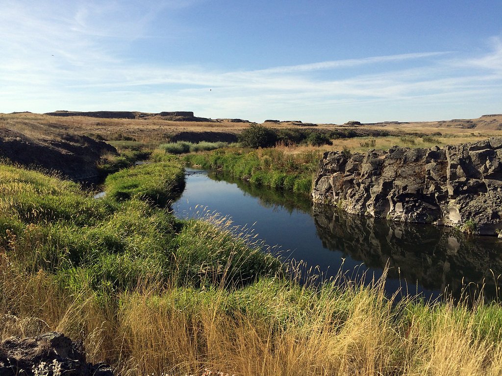
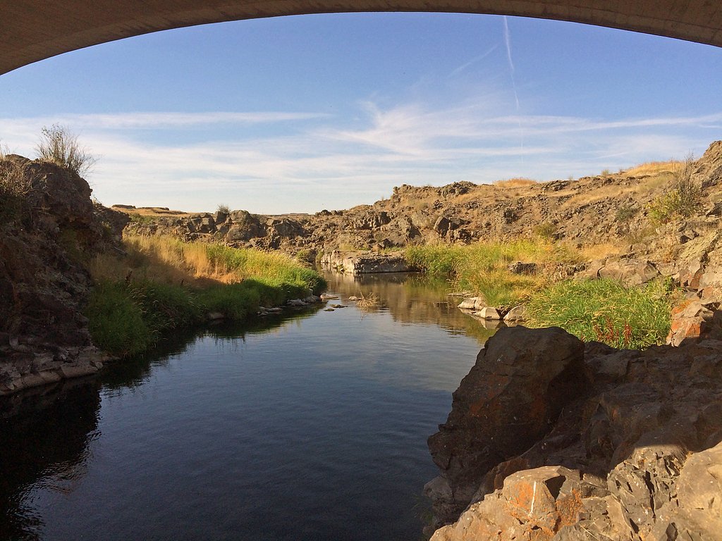
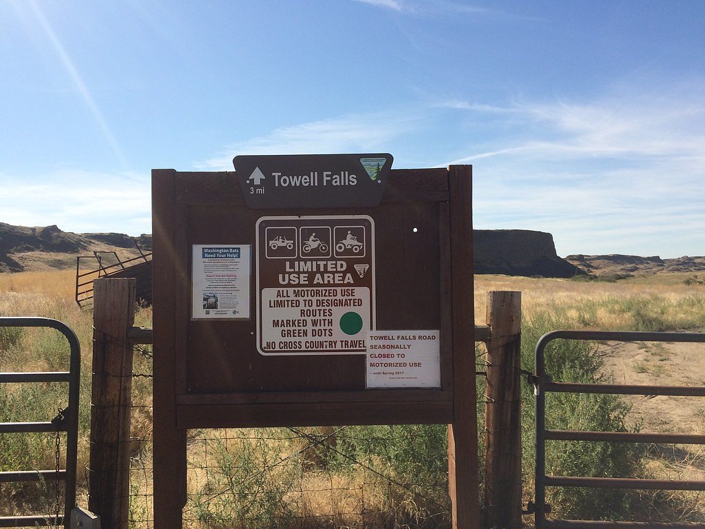
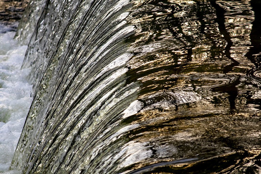
About Towell Falls
Towell Falls is a peaceful, scenic cascade on Pine Creek in eastern Washington, set on public lands managed by the Bureau of Land Management. The falls sit within the BLM’s Spokane Border Field Office jurisdiction (designation: PUB) and offer a quiet escape into a mix of wetlands, grasslands and pocket forest. Spring snowmelt brings the falls to their most dramatic flow, and the surrounding habitat supports a variety of birds and other wildlife—great for photography and low-key wildlife viewing. Access to Towell Falls is via a short hike that keeps the outing friendly for most visitors while still delivering a sense of remoteness. If you’re camping, Rock Creek Recreation Site is just 3.53 km away, making an easy home base for a morning or evening visit. The BLM-managed setting and short approach make Towell Falls a nice half-day destination for hikers and nature lovers looking to explore Pine Creek’s corridor.
The Setting
Towell Falls sits at 1,371 feet within Spokane Border Field Office, fed by the Palouse River, in the foothills of Washington.
Trail & Hike Details
The Approach
The moderate 2.4-mile out-and-back trail gains 350 feet of elevation on the way to the falls.
Trail Description
The trail to Towell Falls is a 2.4-mile out-and-back with about 350 feet of cumulative elevation gain and is rated moderate. The tread generally follows Pine Creek through wetlands, open grassland and stands of trees; the tread is non-technical but includes some short, steeper pitches that account for the moderate rating. Expect a mostly natural surface and clear footpath rather than paved or heavily engineered trail. Wildlife viewing is common along the route—watch for songbirds and larger mammals where the creek and meadow habitats meet. The trail type is out-and-back; bring layers for spring runoff conditions when the falls are at peak flow, and consider camping at nearby Rock Creek Recreation Site (3.53 km) if you want to make an overnight trip of it.
What to Expect
Dogs are welcome.
Accessibility
The trail is not wheelchair accessible. Uneven terrain and elevation changes require steady footing.
Frequently Asked Questions
🐶 Are Dogs Allowed at Towell Falls?
✅ Dogs are allowed
Are There Any Fees or Permits Required?
🤑 Fee: $3.00
🏊 Is There Swimming at Towell Falls?
❌ Swimming is not allowed
When to Visit
Spring is the best time to visit Towell Falls, as the water flow is typically strongest during this season. Summer and fall also offer pleasant conditions, but the flow may be reduced.
Seasonal Access
The best time to visit is Spring, Summer, and Fall. Winter access may be limited.
Safety Information
Be cautious of wildlife and avoid approaching animals. Carry water and be prepared for changing weather conditions. The trail may be muddy or slippery after rain.
Current Water Conditions
Based on a USGS gauge 18.6 miles away
111 ft³/s
Current discharge — how much water is flowing
About average for this time of year
Based on 92 years of record
3.76 ft
Water depth at gauge
7-Day Discharge Trend
What does this mean for your visit?
Flow is about average for this time of year.
About This Gauge
This gauge is on a regional waterway. Conditions at the falls may differ, especially after local rain.
7-Day Flow Outlook
Based on the USGS gauge PALOUSE RIVER AT HOOPER, WA (30 km away).
Today
Barely Flowing
111 cfs
5/10Tomorrow
Barely Flowing
108 cfs
5/10Tue
Barely Flowing
102 cfs
5/10Wed
Barely Flowing
96 cfs
5/10Thu
Barely Flowing
92 cfs
5/10Fri
Barely Flowing
100 cfs
3/10Sat
Barely Flowing
90 cfs
5/10Best window: Today — barely flowing flow, sunny (trip score 5/10).
Best time of year: this gauge typically runs highest from early February to early May, peaking in March.
How we calculate this
This is a transparent outlook, not a precise forecast. We take the waterfall's current flow strength (how it ranks against its historical normal for today, from the nearest USGS stream gauge), carry that ranking forward along the gauge's seasonal curve, and nudge it for forecast rain. Confidence is highest for the next day or two and falls further out. Always check official conditions and your own judgment before visiting — high flows can be dangerous.
Know when to go.
Get a free email alert when waterfalls near LaCrosse hit peak flow. We only send when conditions are worth the trip — no weekly newsletters, no spam.
Weather Forecast
Location & Access
Getting There
Towell Falls is located within the Turnbull National Wildlife Refuge, approximately 30 miles southwest of Spokane, Washington. Visitors can access the falls via Pine Creek Road, which leads to a parking area near the trailhead.
Get Directions on Google MapsParking
There is a small parking area near the trailhead. Parking may be limited during peak seasons.
Elevation
1,371 feet above sea level
Coordinates
46.983689° N, -117.933422° W
Land Management
Managed by BLM
Visitor Tips & Gear
Arrive early during weekends or holidays to secure parking. Bring binoculars for birdwatching and a camera to capture the scenic views. Be prepared for potential muddy sections on the trail, especially after rain.
As an Amazon Associate, we earn from qualifying purchases.
With 2.4 miles and 350 ft of elevation gain, sturdy boots and trekking poles will help on this moderate trail. Sun exposure on the trail makes good sun protection a must in summer.

Polarized Sunglasses (Knockaround)
Cuts glare off the water so you actually see the falls — and your photos turn out better too.

Columbia Watertight II Rain Jacket
Packs into its own pocket, seam-sealed, and keeps you dry from spray and surprise rain.

Earth Pak Waterproof Dry Bag
Keeps your phone and gear dry when waterfall mist soaks everything else.

Waterproof Phone Pouch (AiRunTech)
Cheap insurance — take photos right next to the falls without killing your phone.

Timberland Euro Sprint Mid Waterproof
Trusted waterproof boot with premium leather and grippy rubber sole — reliable on rocky, wet trails.

TrailBuddy Trekking Poles
Lightweight aluminum, cork grips, and flip-locks that actually hold — a best-seller for good reason.
Where to Stay

Browse vacation cabins and private rentals nearby
Unique outdoor stays — tents, yurts, and treehouses
Rent a campervan or RV for your waterfall road trip
Some links are affiliate links. We may earn a commission at no extra cost to you.
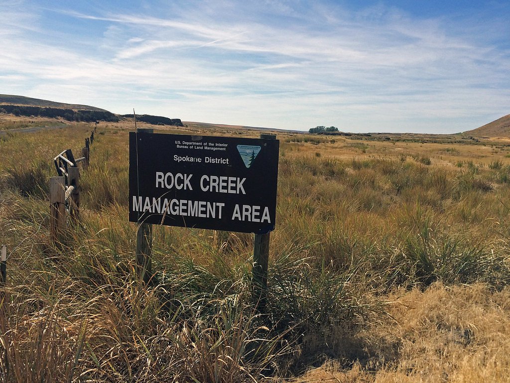
Nearby Campground
Rock Creek Recreation Site
2.2 miles away · 0 sites
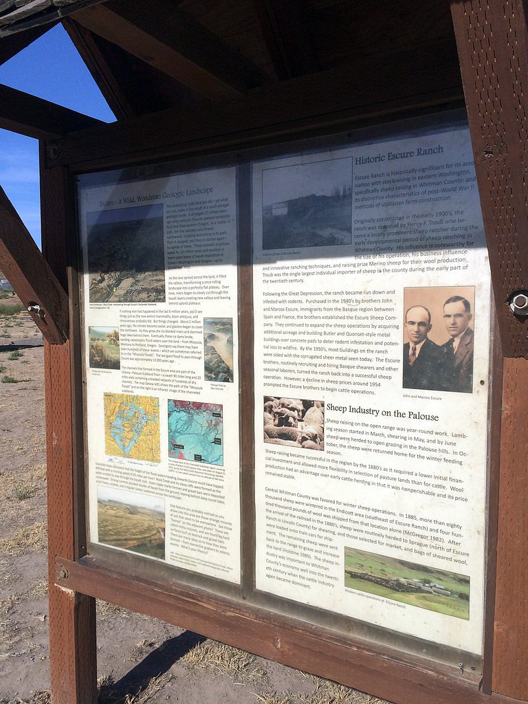
Within BLM’s Rock Creek Management Area, Rock Creek flows through Channeled Scablands, formed approximately 12,000 years ago by massive Glacial Lake Missoula floods. Striking landscapes and geologic features including buttes, mesas, and columnar basalt outcrops enhance the beauty of perennial Rock Creek.The area’s developed Rock Creek Recreation Site is located within view of Rock Creek. It is the area’s primary parking and excursion starting point, via its multiple trailheads, as well as for ove
Book on Recreation.govAdditional Information
Nearby Attractions
The Turnbull National Wildlife Refuge offers additional trails and wildlife viewing opportunities. Spokane, Washington, is nearby and provides dining and lodging options.
Wildlife
The area is home to a variety of wildlife, including moose, deer, coyotes, and over 200 species of birds. Visitors should respect wildlife and maintain a safe distance.
Cities near Towell Falls
Nearby Waterfalls
Writing about Towell Falls? Embed this waterfall on your site for free.