Photo Credits (1)
Difficulty
Moderate
Trail Length
2.4 miles
Trail Type
Out And Back
Elevation Gain
350 ft
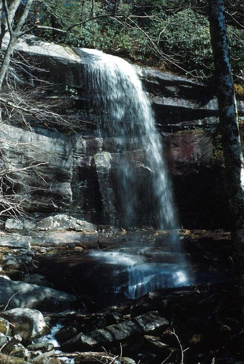
About Thunderhead Falls
Thunderhead Falls is a striking subterranean waterfall that pours from the workings of a former gold mine in the Black Hills, fed by Rapid Creek and set amid the pine‑covered slopes of Black Hills National Forest. Managed by the U.S. Forest Service, the site is one of the area’s oldest tourist attractions — a rare chance to stand in a historic mine tunnel and watch water cascade in an underground chamber. Access to the falls is an inviting short hike that mixes history and forest scenery. The route is on USFS-managed lands and is shown on Forest Service maps as intersecting with the Buzzards Roost Lookout (Trail #54O). The round‑trip outing is about 2.4 miles with roughly 350 feet of elevation gain (moderate difficulty); nearby Bear Gulch Campground is approximately 9.13 km away for anyone looking to turn the visit into an overnight trip. Expect native‑surface tread and some steeper, uneven sections on the approach — sturdy shoes and a headlamp for the tunnel add comfort and safety.
The Setting
Thunderhead Falls sits at 4,190 feet within Black Hills National Forest, fed by the Rapid Creek, in the mountains of South Dakota.
Trail & Hike Details
The Approach
The moderate hike follows Buzzards Roost Lookout (#54O), a 2.4-mile out-and-back trail over natural surface. Expect 350 feet of elevation gain with grades of 10-12%. The trail is developed (Class 3).
USFS Trail
BUZZARDS ROOST LOOKOUT #54O
Trail Class
Developed
Surface
Avg Grade
USFS Segment
0.29 miTrail Description
Out-and-back, 2.4 miles round trip with about 350 feet elevation gain; rated moderate. This route lies within Black Hills National Forest and is managed by the U.S. Forest Service. The USFS map shows the Buzzards Roost Lookout (Trail #54O) with a GIS length of 0.29 miles where it approaches the mine area. Surface: NAT (native material). Typical grade: 10–12%. USFS Class: 3. The trail includes a short historic mine tunnel that leads to the base of the subterranean falls; while the tunnel itself is mostly level, approach sections feature native, uneven tread and moderate grades, so be prepared for some climbing and rocky footing.
What to Expect
Visitors can expect a unique experience walking through a cool, dimly lit mine tunnel to view the waterfall cascading inside the cavern. The sound of rushing water fills the space, creating a serene and memorable atmosphere.
Accessibility
The trail is not wheelchair accessible. Uneven terrain and elevation changes require steady footing.
Frequently Asked Questions
🐶 Are Dogs Allowed at Thunderhead Falls?
❌ Dogs are not allowed
Are There Any Fees or Permits Required?
🤑 Fee: $7.50
🏊 Is There Swimming at Thunderhead Falls?
❌ Swimming is not allowed
When to Visit
The best time to visit is during the summer months when the attraction is fully operational and the weather is pleasant.
Seasonal Access
The best time to visit is Spring, Summer, and Fall. Winter access may be limited. Check with Black Hills National Forest for seasonal road closures.
Safety Information
The mine tunnel can be damp and slippery, so visitors should exercise caution while walking. Flashlights are not necessary but may be helpful for those who prefer additional lighting.
Current Water Conditions
3.01 ft
Water depth at gauge
About This Gauge
Know when to go.
Get a free email alert when waterfalls near Johnson Siding hit peak flow. We only send when conditions are worth the trip — no weekly newsletters, no spam.
Weather Forecast
Location & Access
Getting There
Thunderhead Falls is located approximately 10 miles west of Rapid City, South Dakota, along Thunderhead Falls Road. It is easily accessible by car.
Get Directions on Google MapsParking
There is a small parking area available near the entrance to the site.
Elevation
4,190 feet above sea level
Coordinates
44.058321° N, -103.413521° W
Land Management
Managed by USFS
Visitor Tips & Gear
Wear sturdy shoes as the tunnel floor may be damp and slightly uneven. Bring a light jacket, as the mine can be cool even during warmer months. Arrive early during peak summer season to avoid crowds.
As an Amazon Associate, we earn from qualifying purchases.
With 2.4 miles and 350 ft of elevation gain, sturdy boots and trekking poles will help on this moderate trail. Sun exposure on the trail makes good sun protection a must in summer.

Polarized Sunglasses (Knockaround)
Cuts glare off the water so you actually see the falls — and your photos turn out better too.

Columbia Watertight II Rain Jacket
Packs into its own pocket, seam-sealed, and keeps you dry from spray and surprise rain.

Earth Pak Waterproof Dry Bag
Keeps your phone and gear dry when waterfall mist soaks everything else.

Waterproof Phone Pouch (AiRunTech)
Cheap insurance — take photos right next to the falls without killing your phone.

Timberland Euro Sprint Mid Waterproof
Trusted waterproof boot with premium leather and grippy rubber sole — reliable on rocky, wet trails.

TrailBuddy Trekking Poles
Lightweight aluminum, cork grips, and flip-locks that actually hold — a best-seller for good reason.
Where to Stay

Pine Haven Lodging

Elevation Inn & Suites, Trademark Collection by Wyndham

Comfort Suites Conference Center Rapid City

Microtel Inn & Suites by Wyndham Rapid City
Browse vacation cabins and private rentals nearby
Unique outdoor stays — tents, yurts, and treehouses
Rent a campervan or RV for your waterfall road trip
Some links are affiliate links. We may earn a commission at no extra cost to you.
Nearby Campground
BEAR GULCH
5.7 miles away · 1 sites
Overview This private access group campsite is isolated among the forested Black Hills of South Dakota, overlooking a private bay on the Pactola Reservoir. Great for group events with up to 40 people, there are eight individual tent sites around a central parking area. The summers are pleasant, and the bay provides a great way to cool off on sunny days (summer temperatures range from highs in the mid-80s, to lows in the mid-50s). It can be reserved from Memorial Day through Labor Day. Recreation
Book on Recreation.govNearby Hot Springs
Hot springs near Johnson Siding, South Dakota

Hot Springs
Hot Springs flows at 87°F in downtown Hot Springs, Fall River County, South Dakota, at 3,493 feet elevation, just 88 feet from ...
Hot Brook Springs
Hot Brook Springs flows at 75°F at 3,625 feet elevation near Hot Springs, South Dakota, running 26 degrees above the 49.1°F amb...
Looking for a soak after your hike? Explore more hot springs near Johnson Siding, South Dakota on SoakingSprings.
Explore South Dakota springsAdditional Information
Nearby Attractions
Nearby attractions include Pactola Lake, Black Hills National Forest, and Mount Rushmore National Memorial.
Wildlife
Wildlife sightings are unlikely inside the mine, but the surrounding Black Hills area is home to deer, birds, and other native species.
Cities near Thunderhead Falls
Writing about Thunderhead Falls? Embed this waterfall on your site for free.