
Terrace Falls
By Armen Suny · Last verified Oct 2026
LiDAR & 3D terrainBefore you go
Terrace Falls is on the Flathead Indian Reservation. Non-tribal members need a CSKT tribal recreation (conservation) permit, sold by the CSKT Fish, Wildlife, Recreation and Conservation office in Polson and local vendors, and parts of the Mission Mountains Tribal Wilderness close seasonally for grizzly bears.
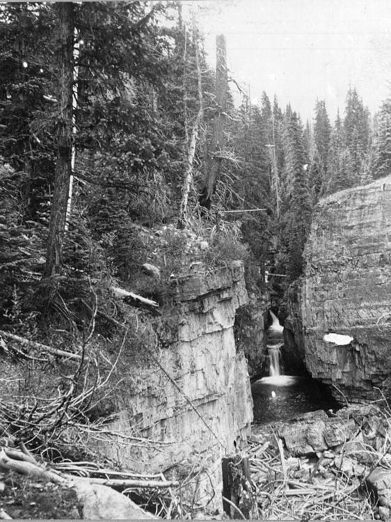


Photo Credits (5)
Trail Type
Out And Back
About Terrace Falls
Terrace Falls is on the west slope of the Mission Range in Lake County, about 7 miles east of Ronan and roughly 0.7 mile west-southwest of Terrace Lake. It lies on the Flathead Indian Reservation side of the range, managed by the Confederated Salish and Kootenai Tribes (CSKT), where non-tribal members need a CSKT tribal recreation permit. The CSKT trail map lists the Terrace Lake Trail at about 4.1 miles; we have not found a reliable distance or elevation gain to the falls themselves.
Trail & Hike Details
Trail Description
The CSKT trail map lists the Terrace Lake Trail at about 4.1 miles to Terrace Lake. The falls sit below the lake, about 0.7 mile to its west-southwest, but no source gives the exact distance from the trailhead to the falls. Carry a map and allow for a mountain trail with sustained climbing.
What to Expect
Visitors can expect a tranquil hike leading to a multi-tiered waterfall surrounded by lush greenery. The sound of cascading water and the natural beauty of the area make it a rewarding experience.
Accessibility
The trail is not wheelchair accessible due to uneven terrain and elevation changes.
Frequently Asked Questions
🐶 Are Dogs Allowed at Terrace Falls?
❌ Dogs are not allowed
Are There Any Fees or Permits Required?
🤑 Fees are required
🏊 Is There Swimming at Terrace Falls?
❌ Swimming is not allowed
When to Visit
The best time to visit Terrace Falls is during late spring or early summer when water flow is at its peak, and the surrounding vegetation is vibrant.
Seasonal Access
The best time to visit is Spring, Summer, and Fall. Access roads and trails may close during winter due to snow.
Safety Information
Be prepared for changing weather conditions and carry bear spray. Watch for slippery rocks near the waterfall and stay on marked trails to avoid getting lost.
Current Water Conditions
These readings come from the USGS gauge on Mission Creek, 13.9 miles away, not on Terrace Falls's own stream. Use them as a sign of whether the area is running wet or dry.
18 ft³/s
Current discharge — how much water is flowing
About average for this time of year
Based on 44 years of record
1.81 ft
Water depth at gauge
7-Day Discharge Trend
What does this mean for your visit?
Flow is about average for this time of year.
About This Gauge
This gauge is on a nearby waterway and may not reflect exact conditions at the falls.
7-Day Flow Outlook
Based on the USGS gauge Mission Creek ab reservoir nr St. Ignatius MT (22 km away).
Today
Barely Flowing
18 cfs
5/10Tomorrow
Barely Flowing
18 cfs
3/10Sat
Barely Flowing
18 cfs
5/10Sun
Barely Flowing
17 cfs
5/10Mon
Barely Flowing
17 cfs
5/10Tue
Barely Flowing
17 cfs
2/10Wed
Barely Flowing
18 cfs
2/10Best window: Today — barely flowing flow, sunny (trip score 5/10).
Best time of year: this gauge typically runs highest from mid May to early August, peaking in June.
How we calculate this
This is a transparent outlook, not a precise forecast. We take the waterfall's current flow strength (how it ranks against its historical normal for today, from the nearest USGS stream gauge), carry that ranking forward along the gauge's seasonal curve, and nudge it for forecast rain. Confidence is highest for the next day or two and falls further out. Always check official conditions and your own judgment before visiting — high flows can be dangerous.
Know when to go.
Get a free email alert when waterfalls near Ronan hit peak flow. We only send when conditions are worth the trip — no weekly newsletters, no spam.
Weather Forecast
The Terrain, Seen by LiDAR
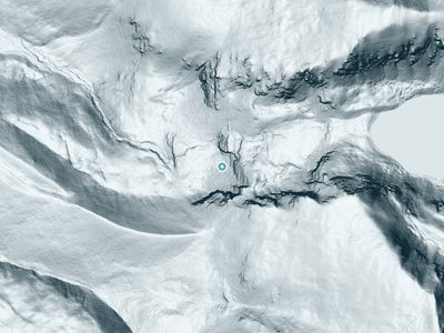
Aircraft-mounted lasers measured this ground to within inches. Trees and buildings are digitally stripped away, leaving the bare shape of the land the water has carved.
The ground through the falls loses about 285 feet in steep steps rather than one leap. The ground at the falls is roughly 6,468 feet above sea level.
Steep ground runs through the entire stretch: about 133 feet of descent in the 500 feet above the pin and 212 feet in the 500 feet below it. Facing west, the falls glow in afternoon and evening light.
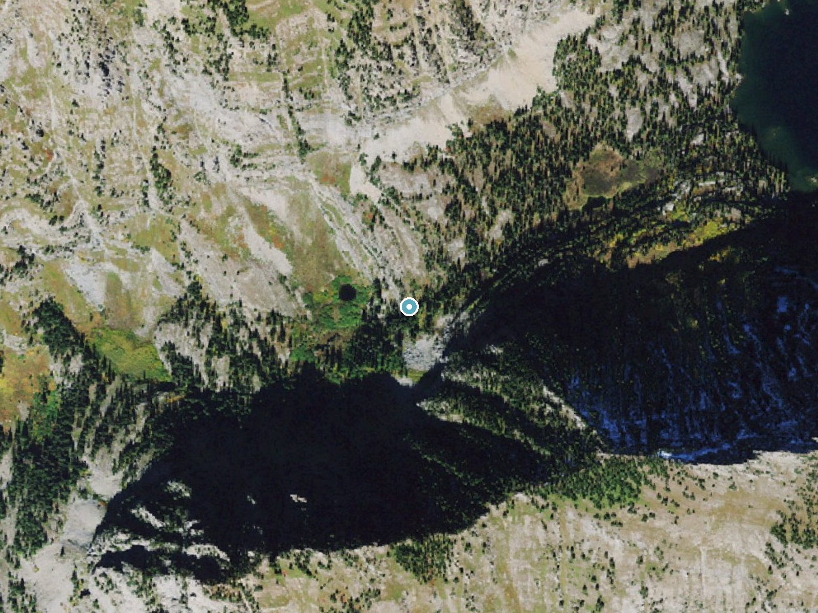
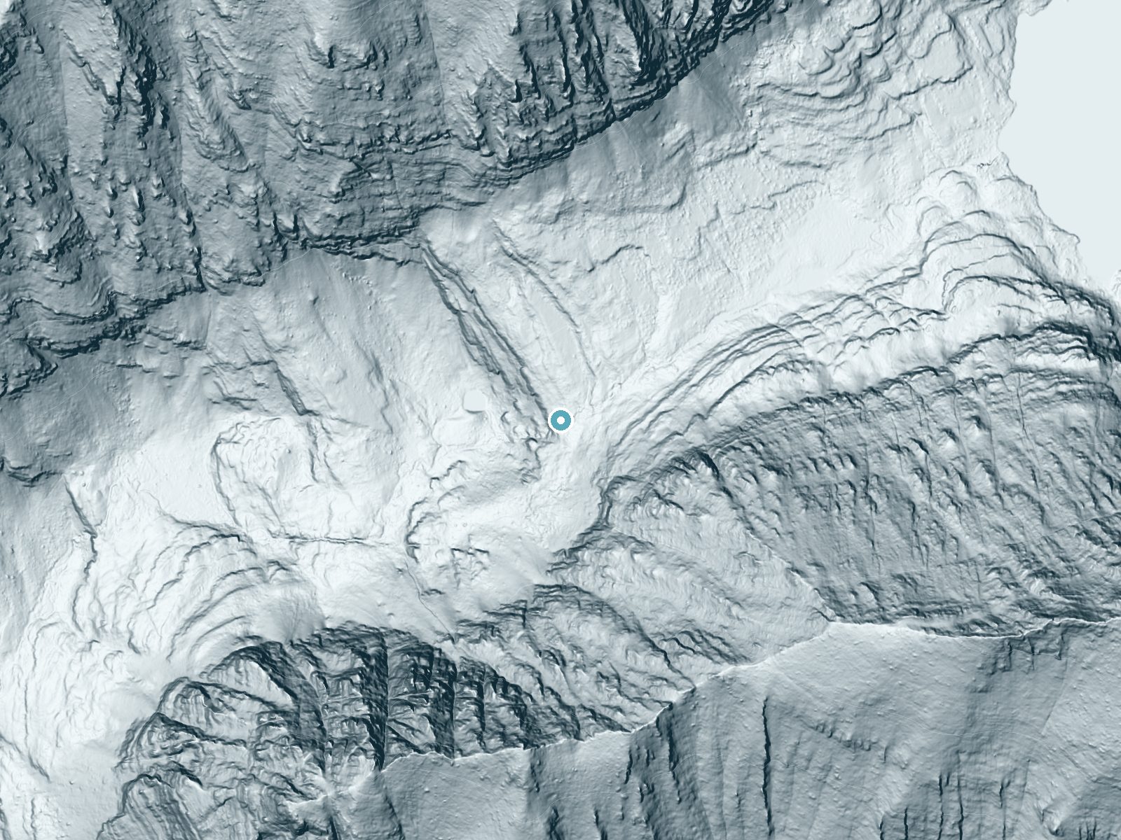
Drag to compare. The dot marks the waterfall. The frame is about a mile across.
- Ground elevation
- 6,468 feet
- Measured by 1-meter lidar
- Drop at the falls
- About 285 feet
- Change in ground height within ~250 feet of the falls
- Faces
- West
- Glows in afternoon and evening light.
A slice through the lidar ground surface, from above the falls to downstream (heading west).
Elevation data: USGS 3D Elevation Program. Aerial imagery: USGS The National Map. Public domain.
Location & Access
Getting There
From the Ronan area, follow the CSKT trail map directions: take Mollman Pass Trail Road to Hammer Dam Lane (Forest Road M-4100), cross the canal to Forest Road M-4010, and at the T-intersection stay left for the Schwartz Lake and Terrace Lake trails (the Mollman Pass Trail is to the right).
Get Directions on Google MapsParking
Parking is available at the trailhead, but spaces may be limited during peak seasons.
Elevation
6,447 feet above sea level
Coordinates
47.519935° N, -113.948992° W
Visitor Tips & Gear
Start your hike early in the day to avoid crowds and ensure you have enough daylight for the return trip. Wear sturdy hiking shoes and bring plenty of water, especially during warmer months.
This trail sits at 6,447 ft above sea level
Elevated TrailUV radiation is roughly 26% stronger at this elevation than at sea level, and the dry air accelerates dehydration. Extra sun protection and fluids go a long way.
As an Amazon Associate, we earn from qualifying purchases.

Coppertone Sport SPF 50 Sunscreen
UV intensity jumps ~4% per 1,000 ft — at this elevation you can burn in half the time.

Sun Bum SPF 30 Lip Balm (3-Pack)
Lips have almost no natural UV protection and burn fast in thin, dry mountain air.

Liquid I.V. Electrolyte Packets
You lose moisture ~2x faster at elevation — electrolytes help you absorb water efficiently.

ROCKNIGHT Polarized UV400 Sunglasses
High-altitude glare off rock and water is intense — UV400 lenses block 99%+ of UVA/UVB.
Where to Stay
Ninepipes Lodge
Secluded Bigfork Cabin with Canoes and Views!

Private Home With Amazing Mountain Views-Two Bedroom and Two Bath

Kwataqnuk Resort & Casino
Browse vacation cabins and private rentals nearby
Unique outdoor stays — tents, yurts, and treehouses
Rent a campervan or RV for your waterfall road trip
Some links are affiliate links. We may earn a commission at no extra cost to you.
Nearby Campground
OLD CONDON RANGER STATION
10.8 miles away · 1 sites
Overview Old Condon Ranger Station is open year-round, providing access to great recreation opportunities in every season. Visitors to the area enjoy fishing in the nearby Swan River, as well as hiking and exploring areas surrounding the cabin. Varieties of birds and wildlife make their home in the area. The cabin provides modern amenities and can be reached by vehicle. Guests are responsible for their own travel arrangements and safety, and must bring some of their own supplies to ensure a comfo
Book on Recreation.govNearby Hot Springs
Hot springs near Polson, Montana
Wild Horse Hot Springs
Wild Horse Hot Springs sits on the Flathead Reservation in Sanders County, Montana, near Plains, at 2,756 feet, one of the lowe...
Green Springs
Green Springs flows at 79°F on the Flathead Reservation in Sanders County, Montana, at 2,813 feet — one of the lower-elevation ...
Camas Hot Springs
Camas Hot Springs flows at 113°F on the Flathead Reservation in western Montana, managed as tribal land with restricted or unkn...
Quinns Hot Springs
Quinns Hot Springs flows at 109 degrees Fahrenheit in the Clark Fork River valley of Sanders County, Montana, at a low elevatio...
Looking for a soak after your hike? Explore more hot springs near Polson, Montana on SoakingSprings.
Explore Montana springsAdditional Information
Nearby Attractions
The Schwartz Lake Trail (about 0.7 mile) and the Mollman Pass Trail (about 4.1 miles) start from the same Forest Road M-4010 system, per the CSKT trail map.
Wildlife
The area is home to a variety of wildlife, including deer, elk, and birds. Be cautious of bears and carry bear spray as a precaution.
Cities near Terrace Falls
Nearby Waterfalls
 LiDAR
Other waterfalls named Terrace Falls
1 other waterfall shares this name across the U.S.
Writing about Terrace Falls? Embed this waterfall on your site for free.