Tank Hollow Falls
By Armen Suny · Last verified May 2026
Photo Credits (1)
Difficulty
Moderate
Trail Length
2.4 miles
Trail Type
Out And Back
Elevation Gain
350 ft
About Tank Hollow Falls
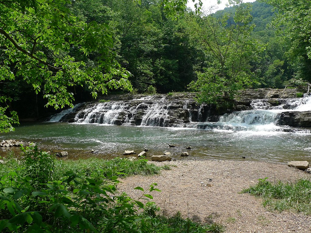
Tank Hollow Falls is a quiet, picture-perfect cascade tucked into the George Washington and Jefferson National Forests, managed by the U.S. Forest Service. This lesser-known gem drops over a rocky ledge into a small plunge pool and is surrounded by lush, forested slopes—an inviting spot for hikers seeking a peaceful nature escape without the crowds. The setting feels remote but is easily reached by a short hike, making it an excellent half-day outing. The hike to the falls is a 2.4-mile out-and-back with roughly 350 feet of elevation gain and is typically rated moderate; it rewards a modest climb with close-up views of the waterfall and a shady place to rest. Note that developed group camping and picnic facilities are not immediate—the nearest listed site, Flatwoods Group Picnic Area, is about 27.6 km away—so plan accordingly for a day trip with water and layered clothing.
The Setting
Tank Hollow Falls sits at 1,545 feet along the Clinch River, in the hills of Virginia.
Trail & Hike Details
The Approach
The moderate 2.4-mile out and back trail gains 350 feet of elevation on the way to the falls.
Trail Description
The trail to Tank Hollow Falls is a 2.4-mile out-and-back that gains about 350 feet, earning a moderate difficulty rating. The path follows a forested corridor on natural tread, with generally gentle to moderate grades that are manageable for most hikers in reasonable condition. It is well-marked and leads directly to the rocky ledge and small pool at the base of the falls; expect typical woodland footing (roots, leaf litter, and occasional rocks). Allow a couple of hours round-trip to enjoy the scenery and take breaks.
What to Expect
Dogs are welcome.
Accessibility
The trail is not wheelchair accessible. Uneven terrain and elevation changes require steady footing.
Frequently Asked Questions
🐶 Are Dogs Allowed at Tank Hollow Falls?
✅ Dogs are allowed
Are There Any Fees or Permits Required?
🆖 No fees required
🏊 Is There Swimming at Tank Hollow Falls?
❌ Swimming is not allowed
When to Visit
Spring and early summer are the best times to visit, as the waterfall flow is typically stronger due to seasonal rainfall.
Seasonal Access
The best time to visit is Spring, Summer, and Fall. Winter access may be limited.
Safety Information
Be cautious of slippery rocks near the waterfall. Check weather conditions before visiting, as heavy rainfall can make trails muddy or hazardous. Cell service may be limited in the area.
Current Water Conditions
440 ft³/s
Current discharge — how much water is flowing
About average for this time of year
Based on 105 years of record
2.43 ft
Water depth at gauge
70°F
WarmVery comfortable
7-Day Discharge Trend
What does this mean for your visit?
Flow is about average for this time of year. Water temperature is a refreshing 70 degrees F, good for a quick swim. Mineral content is typical.
Water Quality
Conductance
Dissolved minerals in the water
About This Gauge
7-Day Flow Outlook
Based on the USGS gauge CLINCH RIVER AT CLEVELAND, VA (1 km away).
Today
Moderate
453 cfs
6/10Tomorrow
Moderate
496 cfs
4/10Sat
Moderate
572 cfs
6/10Sun
Moderate
552 cfs
6/10Mon
Moderate
472 cfs
8/10Tue
Moderate
442 cfs
8/10Wed
Moderate
427 cfs
8/10Best window: Mon — moderate flow, sunny (trip score 8/10).
Best time of year: this gauge typically runs highest from late January to mid April, peaking in February.
How we calculate this
This is a transparent outlook, not a precise forecast. We take the waterfall's current flow strength (how it ranks against its historical normal for today, from the nearest USGS stream gauge), carry that ranking forward along the gauge's seasonal curve, and nudge it for forecast rain. Confidence is highest for the next day or two and falls further out. Always check official conditions and your own judgment before visiting — high flows can be dangerous.
Know when to go.
Get a free email alert when waterfalls near Cleveland hit peak flow. We only send when conditions are worth the trip — no weekly newsletters, no spam.
Weather Forecast
Location & Access
Getting There
Tank Hollow Falls is located in the George Washington and Jefferson National Forests. Access is typically via forest roads, and visitors should check local maps or GPS for the most accurate directions.
Get Directions on Google MapsParking
Parking is available at a small pull-off area near the trailhead. Space may be limited, especially during weekends or peak seasons.
Hours
Elevation
1,545 feet above sea level
Coordinates
36.940107° N, -82.154301° W
Visitor Tips & Gear
Wear sturdy shoes as the trail may have uneven sections. Bring water and snacks, and consider visiting during the spring or after rainfall for the best waterfall flow. Be cautious of slippery rocks near the falls.
As an Amazon Associate, we earn from qualifying purchases.
With 2.4 miles and 350 ft of elevation gain, sturdy boots and trekking poles will help on this moderate trail. Sun exposure on the trail makes good sun protection a must in summer.

Polarized Sunglasses (Knockaround)
Cuts glare off the water so you actually see the falls — and your photos turn out better too.

Columbia Watertight II Rain Jacket
Packs into its own pocket, seam-sealed, and keeps you dry from spray and surprise rain.

Earth Pak Waterproof Dry Bag
Keeps your phone and gear dry when waterfall mist soaks everything else.

Waterproof Phone Pouch (AiRunTech)
Cheap insurance — take photos right next to the falls without killing your phone.

Timberland Euro Sprint Mid Waterproof
Trusted waterproof boot with premium leather and grippy rubber sole — reliable on rocky, wet trails.

TrailBuddy Trekking Poles
Lightweight aluminum, cork grips, and flip-locks that actually hold — a best-seller for good reason.
Where to Stay

Comfort Suites Abingdon I-81

Delta Hotels by Marriott Bristol

Country Inn & Suites by Radisson, Abingdon, VA

Super 8 by Wyndham Lebanon
Browse vacation cabins and private rentals nearby
Unique outdoor stays — tents, yurts, and treehouses
Rent a campervan or RV for your waterfall road trip
Some links are affiliate links. We may earn a commission at no extra cost to you.
Nearby Campground
FLATWOODS GROUP PICNIC AREA
17.1 miles away · 1 sites
Overview Flatwoods Group Picnic area is a secluded site surrounded by forest. It is a great facility for family reunions, organization activities and other group events. Recreation Open lawn areas are adjacent to the picnic area which can be used for activities such as horseshoes, sports and games (bring your own game and sports equipment). Hiking trails are available within easy driving distance (Guest River Gorge, Chief Benges Scout, and Little Stony Falls Trails). Facilities A paved parking lo
Book on Recreation.govAdditional Information
Nearby Attractions
The George Washington and Jefferson National Forests offer numerous hiking trails, scenic overlooks, and opportunities for camping and wildlife observation.
Wildlife
The area is home to a variety of wildlife, including deer, birds, and small mammals. Visitors should be aware of the potential presence of snakes and other forest creatures.
Cities near Tank Hollow Falls
Nearby Waterfalls
Writing about Tank Hollow Falls? Embed this waterfall on your site for free.