T Lake Falls
New York • 600 ft
By Armen Suny · Last verified Mar 2026

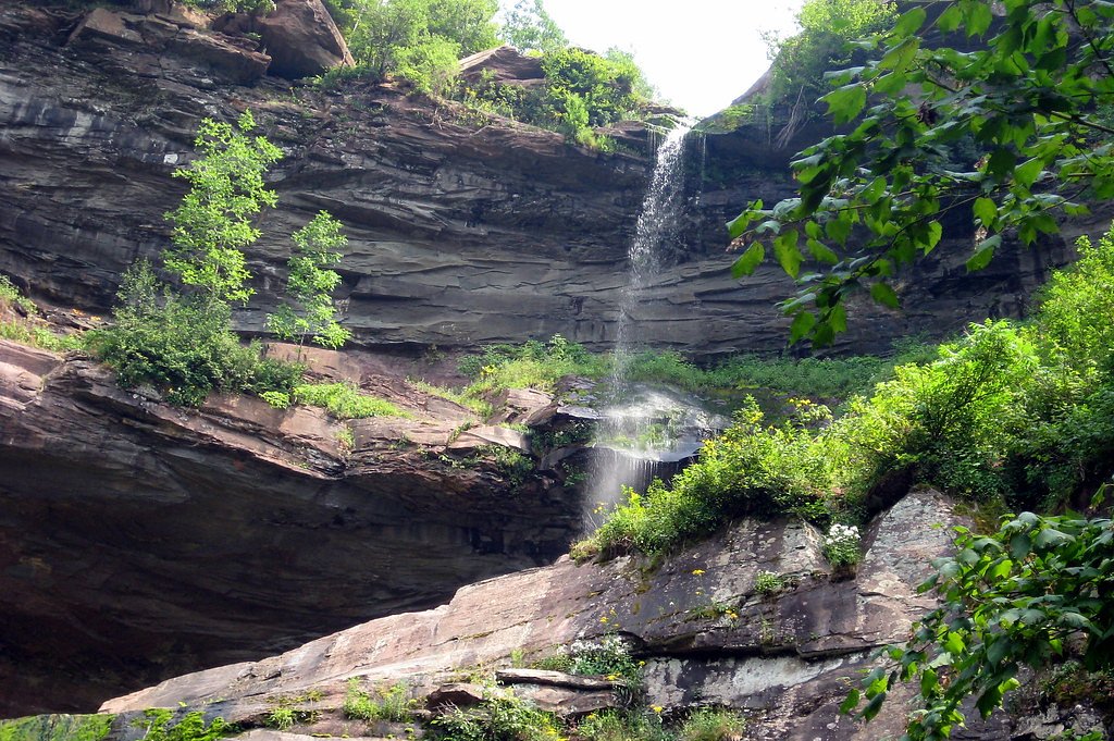
Photo Credits (5)
Difficulty
Hard
Trail Length
10.0 miles
Trail Type
Out And Back
Elevation Gain
1,500 ft
About T Lake Falls
T Lake Falls is a remote, multi-tiered cascade tucked in the West Canada Lake Wilderness of Hamilton County, New York. Widely reported as the tallest waterfall in both New York State and the Adirondacks, sources place its total drop anywhere from about 350 feet up to 600 feet; the variation stems from how observers define the crest and the official start of the falls. At even the lower estimates, the falls are at least double the vertical height of Niagara Falls, making the site a dramatic reward for the long hike in. The falls sit within the West Canada Lake Wilderness, managed by SDC (designation: SW), and its secluded setting means fewer crowds and a deep-wilderness experience for visitors who make the trek. Expect striking viewpoints framed by rugged forest and layered rock; because access is remote and the terrain is rugged, come prepared for a serious backcountry outing rather than a short roadside stop.
The Setting
T Lake Falls sits at 2,323 feet within West Canada Lake Wilderness, fed by the West Canada Creek, in the hills of New York. At 600 feet, it is among the taller waterfalls in New York.
Height: 600 feet
Trail & Hike Details
The Approach
The hard 10.0-mile out-and-back trail gains 1,500 feet of elevation on the way to the falls.
Trail Description
Trail to T Lake Falls is a long, hard out-and-back (approximately 10.0 miles round trip) with roughly 1,500 feet of elevation gain. Difficulty is rated hard—plan for a full day or an overnight if you prefer a slower pace. The route is ungraded for developed trail classes in the available data, so use map and navigation skills for the remote setting. On the ground the hike traverses dense forest and rugged terrain; hikers should be prepared for muddy sections, downed trees, steep inclines, and uneven footing. The final approach to the falls requires careful navigation and may involve scrambling over rocks to reach the best viewpoints, so sturdy footwear and caution are essential.
What to Expect
The falls plunge a dramatic 600 feet. Dogs are welcome.
Accessibility
The trail involves steep, uneven terrain with significant elevation change and is not accessible to mobility devices.
Frequently Asked Questions
🐶 Are Dogs Allowed at T Lake Falls?
✅ Dogs are allowed
Are There Any Fees or Permits Required?
🆖 No fees required
🏊 Is There Swimming at T Lake Falls?
❌ Swimming is not allowed
When to Visit
Spring and early summer are ideal for visiting T Lake Falls, as the water flow is typically strongest during these seasons. Fall offers beautiful foliage, while winter provides a unique view of the frozen waterfall for experienced hikers.
Seasonal Access
The best time to visit is Spring, Summer, and Fall. Winter access may be limited.
Safety Information
The trail to T Lake Falls is remote and can be dangerous for unprepared hikers. Be cautious of slippery rocks, steep sections, and changing weather conditions. Always let someone know your plans before heading out.
Current Water Conditions
Based on a USGS gauge 18.4 miles away
174 ft³/s
Current discharge — how much water is flowing
Lower than usual for this time of year
Based on 25 years of record
2.56 ft
Water depth at gauge
7-Day Discharge Trend
What does this mean for your visit?
Flow is lower than usual for this time of year.
About This Gauge
This gauge is on a regional waterway. Conditions at the falls may differ, especially after local rain.
7-Day Flow Outlook
Based on the USGS gauge WEST CANADA CREEK NEAR WILMURT NY (30 km away).
Today
Barely Flowing
174 cfs
5/10Tomorrow
Barely Flowing
223 cfs
5/10Tue
Low
211 cfs
3/10Wed
Low
230 cfs
3/10Thu
Barely Flowing
257 cfs
5/10Fri
Low
276 cfs
3/10Sat
Low
232 cfs
3/10Best window: Today — barely flowing flow, mostly sunny (trip score 5/10).
Best time of year: this gauge typically runs highest from late March to early May, peaking in April.
How we calculate this
This is a transparent outlook, not a precise forecast. We take the waterfall's current flow strength (how it ranks against its historical normal for today, from the nearest USGS stream gauge), carry that ranking forward along the gauge's seasonal curve, and nudge it for forecast rain. Confidence is highest for the next day or two and falls further out. Always check official conditions and your own judgment before visiting — high flows can be dangerous.
Know when to go.
Get a free email alert when waterfalls near Speculator hit peak flow. We only send when conditions are worth the trip — no weekly newsletters, no spam.
Weather Forecast
Location & Access
Getting There
T Lake Falls is located in the West Canada Lake Wilderness of the Adirondack Park. The trailhead is accessed from Piseco, New York, via the T Lake Trail. The trailhead is unmarked but can be found near the end of Old Piseco Road.
Get Directions on Google MapsParking
Limited parking is available near the trailhead on Old Piseco Road. Visitors should arrive early to secure a spot.
Elevation
2,323 feet above sea level
Coordinates
43.456458° N, -74.612931° W
Land Management
Managed by SDC
Visitor Tips & Gear
Start early to allow plenty of time for the hike. Wear sturdy hiking boots and bring a map or GPS device, as the trail can be difficult to follow. Be prepared for changing weather conditions and carry enough water and snacks.
As an Amazon Associate, we earn from qualifying purchases.
This challenging 10.0 miles trail gains 1,500 ft in elevation — come prepared with proper hiking boots and trekking poles. Sun exposure on the trail makes good sun protection a must in summer.

Sawyer Squeeze Water Filter
The backcountry standard — filters 99.9% of bacteria and weighs just 3 oz.

Polarized Sunglasses (Knockaround)
Cuts glare off the water so you actually see the falls — and your photos turn out better too.

Columbia Watertight II Rain Jacket
Packs into its own pocket, seam-sealed, and keeps you dry from spray and surprise rain.

Earth Pak Waterproof Dry Bag
Keeps your phone and gear dry when waterfall mist soaks everything else.

Waterproof Phone Pouch (AiRunTech)
Cheap insurance — take photos right next to the falls without killing your phone.

Timberland Euro Sprint Mid Waterproof
Trusted waterproof boot with premium leather and grippy rubber sole — reliable on rocky, wet trails.
Where to Stay

Adirondack Lodge Old Forge

Great Pines

The Lorca Adirondacks Motel

Conveniently Located Old Forge Condo Near Downtown
Browse vacation cabins and private rentals nearby
Unique outdoor stays — tents, yurts, and treehouses
Rent a campervan or RV for your waterfall road trip
Some links are affiliate links. We may earn a commission at no extra cost to you.
Additional Information
Nearby Attractions
Piseco Lake, West Canada Lake Wilderness, and other hiking trails in the Adirondack Park.
Wildlife
The area is home to a variety of wildlife, including deer, black bears, and numerous bird species. Visitors should practice bear safety and store food properly.
Cities near T Lake Falls
Writing about T Lake Falls? Embed this waterfall on your site for free.