
Photo Credits (2)
Difficulty
Moderate
Trail Length
2.4 miles
Trail Type
Out And Back
Elevation Gain
350 ft
About Sweetheart Falls
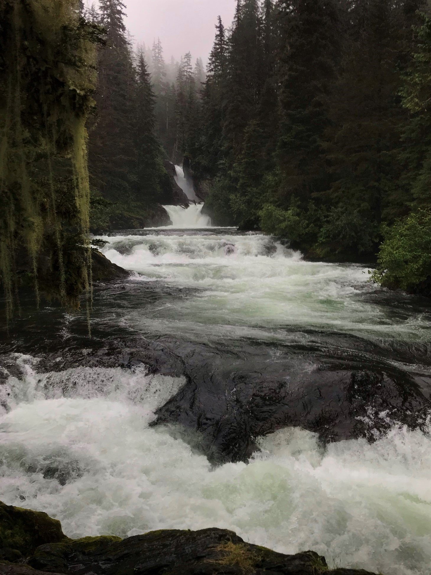
Sweetheart Falls is a secluded, picture-postcard cascade tucked into Southeast Alaska near Sweetheart Creek. Nestled within the USFS-managed Tongass National Forest, the falls are surrounded by dense temperate rainforest and rugged coastal terrain, and they draw anglers during the salmon run when fish congregate downstream. The setting feels remote and pristine—perfect for visitors who want a quiet, wilderness waterfall experience. Access is for prepared hikers and anglers: the approach is an unmaintained route of approximately 2.4 miles round-trip (out-and-back) with about 350 feet of elevation gain and is typically rated moderate. Because this is USFS land with no constructed trail to the falls, expect undeveloped, uneven footing and to rely on map and route-finding skills. Pack for wet conditions, bring proper footwear, and plan for a slow, contemplative visit rather than a quick roadside stop.
The Setting
Sweetheart Falls sits at 397 feet within Tongass National Forest, in the coastal lowlands of Alaska.
Trail & Hike Details
The Approach
The moderate 2.4-mile out-and-back trail gains 350 feet of elevation on the way to the falls.
Trail Description
Trail type: out-and-back; Length: 2.4 miles round-trip; Elevation gain: ~350 feet; Difficulty: Moderate. The falls lie on USFS land in Tongass National Forest, but there is no constructed or maintained USFS trail to the waterfall. The approach follows a primitive, unmarked route across rugged, undeveloped terrain—expect uneven surfaces, stream crossings, and variable grade. Navigation skills and wilderness preparation are required; the route is non-technical but not maintained or signed by the Forest Service.
What to Expect
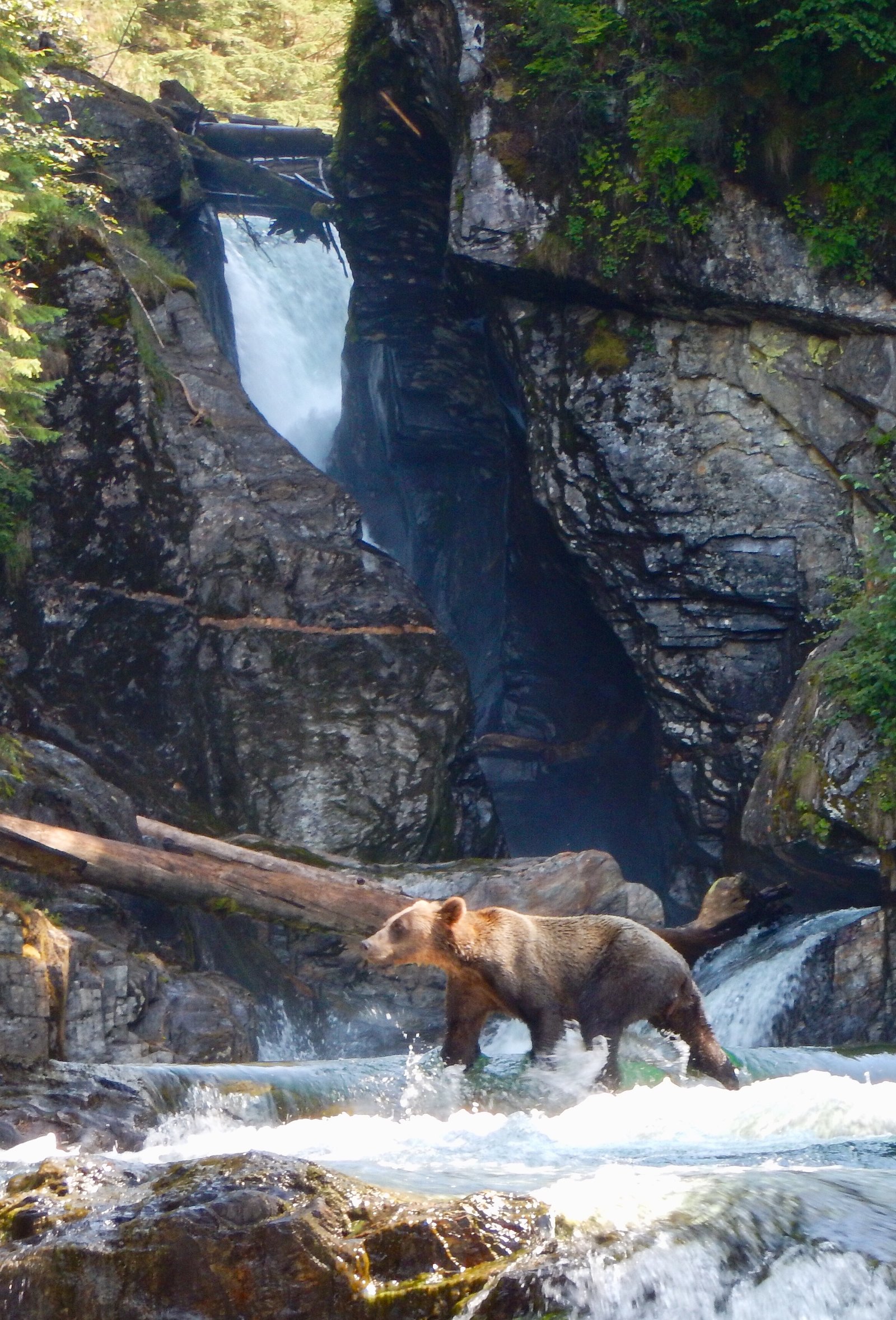
Expect a remote and pristine wilderness experience. The falls are surrounded by dense forest and rocky terrain. Wildlife sightings, including bears, are common in the area, especially during the salmon run.
Accessibility
The trail is not wheelchair accessible. Uneven terrain and elevation changes require steady footing.
Frequently Asked Questions
🐶 Are Dogs Allowed at Sweetheart Falls?
❌ Dogs are not allowed
Are There Any Fees or Permits Required?
🆖 No fees required
🏊 Is There Swimming at Sweetheart Falls?
❌ Swimming is not allowed
When to Visit
The best time to visit is during the summer months (June to August) when the weather is more favorable, and the salmon run attracts wildlife to the area.
Seasonal Access
The best time to visit is Spring, Summer, and Fall. Winter access may be limited. Check with Tongass National Forest for seasonal road closures.
Safety Information
Visitors should be prepared for remote wilderness conditions. Carry bear spray and be aware of wildlife, especially during the salmon run. Weather can change rapidly, so bring appropriate gear and check conditions before traveling.
Know when to go.
Get a free email alert when waterfalls near Juneau hit peak flow. We only send when conditions are worth the trip — no weekly newsletters, no spam.
Weather Forecast
Location & Access
Getting There
Sweetheart Falls is accessible only by boat or floatplane, as it is located in a remote area near Sweetheart Creek, approximately 40 miles south of Juneau, Alaska. Visitors typically travel to the area by chartered boat or private vessel.
Get Directions on Google MapsParking
There is no parking available as the falls are only accessible by water or air.
Elevation
397 feet above sea level
Coordinates
57.945278° N, -133.676667° W
Land Management
Managed by USFS
Visitor Tips & Gear
Bring appropriate gear for hiking in rugged terrain, including waterproof boots and navigation tools. Be prepared for changing weather conditions and carry bear spray. If visiting during the salmon run, exercise caution as bears may be present.
As an Amazon Associate, we earn from qualifying purchases.
With 2.4 miles and 350 ft of elevation gain, sturdy boots and trekking poles will help on this moderate trail. Sun exposure on the trail makes good sun protection a must in summer.

Polarized Sunglasses (Knockaround)
Cuts glare off the water so you actually see the falls — and your photos turn out better too.

Columbia Watertight II Rain Jacket
Packs into its own pocket, seam-sealed, and keeps you dry from spray and surprise rain.

Earth Pak Waterproof Dry Bag
Keeps your phone and gear dry when waterfall mist soaks everything else.

Waterproof Phone Pouch (AiRunTech)
Cheap insurance — take photos right next to the falls without killing your phone.

Timberland Euro Sprint Mid Waterproof
Trusted waterproof boot with premium leather and grippy rubber sole — reliable on rocky, wet trails.

TrailBuddy Trekking Poles
Lightweight aluminum, cork grips, and flip-locks that actually hold — a best-seller for good reason.
Where to Stay
Browse vacation cabins and private rentals nearby
Unique outdoor stays — tents, yurts, and treehouses
Rent a campervan or RV for your waterfall road trip
Some links are affiliate links. We may earn a commission at no extra cost to you.
Additional Information
Nearby Attractions
Sweetheart Creek is a popular spot for fishing, especially during the salmon run. The surrounding Tongass National Forest offers opportunities for wildlife viewing and exploring the Alaskan wilderness.
Wildlife
The area is home to a variety of wildlife, including bears, eagles, and salmon during the spawning season.
Cities near Sweetheart Falls
Writing about Sweetheart Falls? Embed this waterfall on your site for free.