Sutton Falls
By Armen Suny · Last verified May 2026
Photo Credits (1)
Difficulty
Moderate
Trail Length
2.4 miles
Trail Type
Out And Back
Elevation Gain
350 ft
About Sutton Falls
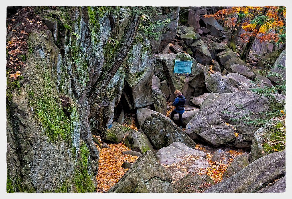
Sutton Falls is a small, picture‑worthy cascade tucked into a peaceful woodland setting in Sutton, Massachusetts. The falls are a popular local destination for a short nature escape—enough to feel immersed in the sights and sounds of rushing water without committing to a long backcountry trek. The approach rewards visitors with a sense of seclusion and classic New England scenery. You reach Sutton Falls via a moderate, out‑and‑back hike that climbs roughly 350 feet over the course of the route. The trail is well suited to hikers looking for a half‑day outing: it’s short but steady, and the modest elevation change makes for a satisfying payoff at the water. Visitors should wear sturdy footwear and check local trail reports before heading out, as conditions can vary with weather and seasons.
The Setting
Sutton Falls sits at 531 feet along the Blackstone River, W. Main St.,, in the foothills of Massachusetts.
Trail & Hike Details
The Approach
The moderate 2.4-mile out-and-back trail gains 350 feet of elevation on the way to the falls.
Trail Description
Trail length: 2.4 miles (out-and-back); Elevation gain: ~350 feet; Difficulty: moderate. Detailed USFS trail surface, grade, and class information is not reported for this route. Expect a natural, unpaved footpath with some uneven footing and short climbs; hikers should prepare with appropriate footwear, water, and up-to-date local trail information before setting out.
What to Expect
Visitors can expect a peaceful natural setting with a small waterfall surrounded by trees and vegetation. The area is ideal for a quiet outing or photography.
Accessibility
The trail is not wheelchair accessible. Uneven terrain and elevation changes require steady footing.
Frequently Asked Questions
🐶 Are Dogs Allowed at Sutton Falls?
❌ Dogs are not allowed
Are There Any Fees or Permits Required?
🆖 No fees required
🏊 Is There Swimming at Sutton Falls?
❌ Swimming is not allowed
When to Visit
Spring and early summer are ideal times to visit, as the waterfall is likely to have the most water flow due to seasonal rains.
Seasonal Access
The best time to visit is Spring, Summer, and Fall. Winter access may be limited.
Safety Information
Visitors should be cautious of slippery rocks near the waterfall and uneven terrain. Always stay on marked trails and avoid venturing too close to the water.
Current Water Conditions
55 ft³/s
Current discharge — how much water is flowing
Much lower than usual for this time of year
Based on 23 years of record
1.69 ft
Water depth at gauge
7-Day Discharge Trend
What does this mean for your visit?
Flow is well below normal for this time of year, so the waterfall may be a trickle.
About This Gauge
This gauge is on a nearby waterway and may not reflect exact conditions at the falls.
7-Day Flow Outlook
Based on the USGS gauge BLACKSTONE RIVER, W. MAIN ST., AT MILLBURY, MA (9 km away).
Today
Moderate
55 cfs
8/10Tomorrow
Moderate
60 cfs
4/10Wed
Moderate
61 cfs
6/10Thu
Moderate
64 cfs
8/10Fri
Moderate
55 cfs
4/10Sat
Moderate
54 cfs
6/10Sun
Moderate
59 cfs
6/10Best window: Today — moderate flow, mostly sunny (trip score 8/10).
Best time of year: this gauge typically runs highest from early March to late April, peaking in April.
How we calculate this
This is a transparent outlook, not a precise forecast. We take the waterfall's current flow strength (how it ranks against its historical normal for today, from the nearest USGS stream gauge), carry that ranking forward along the gauge's seasonal curve, and nudge it for forecast rain. Confidence is highest for the next day or two and falls further out. Always check official conditions and your own judgment before visiting — high flows can be dangerous.
Know when to go.
Get a free email alert when waterfalls near East Douglas hit peak flow. We only send when conditions are worth the trip — no weekly newsletters, no spam.
Weather Forecast
Location & Access
Getting There
Sutton Falls is located near Sutton, Massachusetts. It is accessible by local roads, and visitors should use GPS to navigate to the area. Specific directions may vary depending on the starting location.
Get Directions on Google MapsParking
Parking availability is limited and may be located near the trailhead or roadside. Visitors should check for signage and avoid blocking private property.
Elevation
531 feet above sea level
Coordinates
42.109818° N, -71.782293° W
Visitor Tips & Gear
Wear sturdy shoes as the terrain may be uneven. Bring water and check weather conditions before visiting. Be mindful of private property in the area.
As an Amazon Associate, we earn from qualifying purchases.
With 2.4 miles and 350 ft of elevation gain, sturdy boots and trekking poles will help on this moderate trail. Sun exposure on the trail makes good sun protection a must in summer.

Polarized Sunglasses (Knockaround)
Cuts glare off the water so you actually see the falls — and your photos turn out better too.

Columbia Watertight II Rain Jacket
Packs into its own pocket, seam-sealed, and keeps you dry from spray and surprise rain.

Earth Pak Waterproof Dry Bag
Keeps your phone and gear dry when waterfall mist soaks everything else.

Waterproof Phone Pouch (AiRunTech)
Cheap insurance — take photos right next to the falls without killing your phone.

Timberland Euro Sprint Mid Waterproof
Trusted waterproof boot with premium leather and grippy rubber sole — reliable on rocky, wet trails.

TrailBuddy Trekking Poles
Lightweight aluminum, cork grips, and flip-locks that actually hold — a best-seller for good reason.
Where to Stay

Holiday Inn Express Hotel & Suites Auburn by IHG

Comfort Inn Auburn-Worcester

La Quinta Inn by Wyndham Auburn Worcester

Fairfield by Marriott Inn & Suites Worcester Auburn
Browse vacation cabins and private rentals nearby
Unique outdoor stays — tents, yurts, and treehouses
Rent a campervan or RV for your waterfall road trip
Some links are affiliate links. We may earn a commission at no extra cost to you.
Nearby Campground
Buffumville Lake (Group Shelter)
6.5 miles away · 1 sites
Overview In 1958 the U.S. Army Corps of Engineers built Buffumville Dam in Charlton, Massachusetts to provide flood risk management for downstream communities. Flood waters due to large amounts of rainfall or spring snow melts are stored on 480 acres of land. The lake is also managed for recreation and environmental stewardship. Buffumville offers year-round recreation and park rangers are available to assist you during your visit. Recreation Buffumville Lake provides excellent boating, canoeing,
Book on Recreation.govAdditional Information
Nearby Attractions
The town of Sutton offers other outdoor activities and scenic spots, including Purgatory Chasm State Reservation, which is a popular hiking and climbing destination.
Wildlife
The area around Sutton Falls may feature local wildlife such as birds, small mammals, and insects. Visitors should respect the natural habitat.
Cities near Sutton Falls
Writing about Sutton Falls? Embed this waterfall on your site for free.