Sturtevant Falls
California • 50 ft
By Armen Suny · Last verified Mar 2026
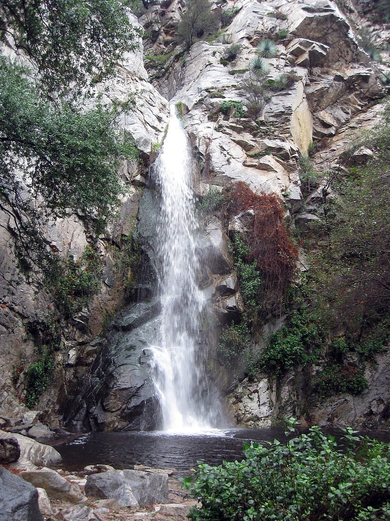
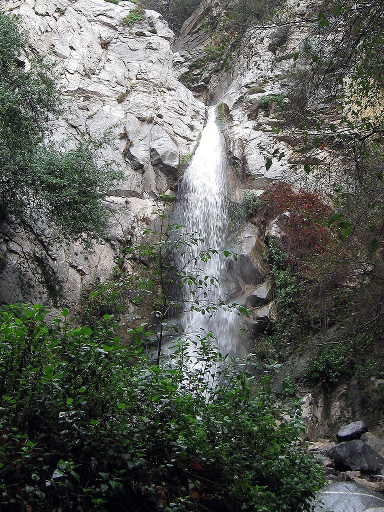

Photo Credits (5)
Difficulty
Moderate
Trail Length
3.3 miles
Trail Type
Out And Back
Elevation Gain
400 ft
About Sturtevant Falls
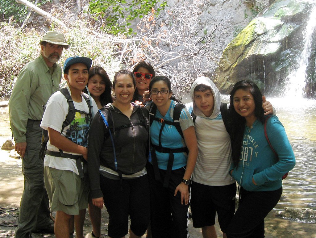
Sturtevant Falls is a scenic 50-foot cascade tucked into Santa Anita Canyon within the Angeles National Forest, just outside Sierra Madre, California. Managed by the U.S. Forest Service, the falls are a favorite day-hike destination for families and photographers: a shady, creekside approach leads to a broad cascade and a pleasant pool at the base where hikers often pause to relax and take photos. The route blends riparian vegetation with the canyon’s rock walls and a handful of historic cabins near the trail, offering a mix of natural beauty and local history in a relatively accessible setting. The hike to Sturtevant is an out-and-back of approximately 3.25 miles with about 400 feet of elevation gain and a moderate difficulty rating. The trail begins at the Chantry Flat parking area and is well used and well maintained, making it a reliable option for most fit day hikers looking for a classic Southern California canyon walk without technical scrambling.
The Setting
Sturtevant Falls sits at 2,113 feet in the hills of California. The falls drop 50 feet.
Height: 50 feet
Trail & Hike Details
The Approach
The moderate 3.25-mile out-and-back trail gains 400 feet of elevation on the way to the falls.
Trail Description
Trailhead: Chantry Flat parking area. Type: out-and-back, length ~3.25 miles total, elevation gain ~400 ft, difficulty: moderate. Surface and route: a well‑trodden dirt and compacted‑rock footpath that descends into Santa Anita Canyon and stays largely shaded alongside the creek. The route passes historic cabins and lush riparian vegetation and includes occasional short, steeper pitches near the canyon floor; no technical climbing is required. The trail terminates at the base of the 50-foot Sturtevant Falls, where a rocky pool and viewing area mark the turnaround point.
What to Expect
The falls drop 50 feet. Dogs are welcome.
Accessibility
The trail is not wheelchair accessible. Uneven terrain and elevation changes require steady footing.
Frequently Asked Questions
🐶 Are Dogs Allowed at Sturtevant Falls?
✅ Dogs are allowed
Are There Any Fees or Permits Required?
🤑 Fee: $5.00
🏊 Is There Swimming at Sturtevant Falls?
❌ Swimming is not allowed
When to Visit
The best time to visit is in the spring or after winter rains, when the waterfall is at its fullest. Early mornings or weekdays are ideal to avoid crowds.
Seasonal Access
The best time to visit is Spring, Fall, and Winter.
Safety Information
Be cautious of slippery rocks near the waterfall and along the creek. Watch for poison oak along the trail. Flash flooding may occur during heavy rains, so check weather conditions before visiting.
Current Water Conditions
0 ft³/s
Current discharge — how much water is flowing
Based on 76 years of record
7.05 ft
Water depth at gauge
About This Gauge
This gauge is on a nearby waterway and may not reflect exact conditions at the falls.
Know when to go.
Get a free email alert when waterfalls near Sierra Madre hit peak flow. We only send when conditions are worth the trip — no weekly newsletters, no spam.
Weather Forecast
Location & Access
Getting There
Sturtevant Falls is accessed via the Chantry Flat Recreation Area. From Sierra Madre, take Santa Anita Avenue north until it ends at the Chantry Flat parking lot.
Get Directions on Google MapsParking
Parking is available at the Chantry Flat Recreation Area, but it can fill up quickly, especially on weekends. An Adventure Pass is required to park here.
Elevation
2,113 feet above sea level
Coordinates
34.211657° N, -118.019512° W
Visitor Tips & Gear
Arrive early to secure parking, especially on weekends. Bring plenty of water, as the trail can get warm during the day. Wear sturdy shoes, as parts of the trail may be uneven or slippery.
As an Amazon Associate, we earn from qualifying purchases.
With 3.3 miles and 400 ft of elevation gain, sturdy boots and trekking poles will help on this moderate trail. Icy conditions are common in winter — traction cleats are a smart addition.

Columbia Watertight II Rain Jacket
Packs into its own pocket, seam-sealed, and keeps you dry from spray and surprise rain.

Earth Pak Waterproof Dry Bag
Keeps your phone and gear dry when waterfall mist soaks everything else.

Waterproof Phone Pouch (AiRunTech)
Cheap insurance — take photos right next to the falls without killing your phone.

Timberland Euro Sprint Mid Waterproof
Trusted waterproof boot with premium leather and grippy rubber sole — reliable on rocky, wet trails.

TrailBuddy Trekking Poles
Lightweight aluminum, cork grips, and flip-locks that actually hold — a best-seller for good reason.

Kahtoola MICROspikes
Cult-favorite traction cleats that grip ice and wet rock — essential for winter waterfall hikes.
Where to Stay

Hampton Inn Los Angeles/Arcadia

Days Inn by Wyndham Near City Of Hope

Le Meridien Pasadena Arcadia

Courtyard by Marriott Los Angeles Pasadena/Monrovia
Browse vacation cabins and private rentals nearby
Unique outdoor stays — tents, yurts, and treehouses
Rent a campervan or RV for your waterfall road trip
Some links are affiliate links. We may earn a commission at no extra cost to you.
Nearby Campground
BANDIDO GROUP CAMPGROUND
9.3 miles away · 5 sites
Overview Groups of all types will enjoy staying at the Bandido Group Campground, which boasts beautiful scenery in a relaxing, rustic atmosphere. The site accommodates groups of up to 150 campers, but is designed for equestrian campers and provides several horse corrals and hitch racks. Bandido is divided into five campsites, each with varying capacities for smaller groups. Site #1 has a capacity of 12 campers. Site #2 can accommodate 60 campers. Site #3 and #5 can each hold a maximum of 30 campe
Book on Recreation.govNearby Hot Springs
Hot springs near Sierra Madre, California
Radium Sulphur Springs
Radium Sulphur Springs occupies a remarkable position immediately alongside Melrose Avenue in Hollywood, emerging virtually roa...

El Encino Springs
El Encino Springs emerges at 79°F from the urban heart of Sherman Oaks, representing one of the few remaining traces of histori...

Tylers Bath Spring
Tyler's Bath Spring emerges at 92 degrees in the San Bernardino National Forest, producing water 30 degrees warmer than the amb...
Fairview Hot Spring
Fairview Hot Spring represents a unique geothermal oddity in Orange County: an artesian well that tapped heated groundwater and...

Arrowhead Springs, Waterman Hot Spr
Arrowhead Springs and Waterman Hot Springs discharge at 194°F (90°C) in the San Bernardino Mountains, among Southern California...

Unnamed Spring Los Angeles County
This rare thermal spring emerges near Palos Verdes Estates at just 127 feet elevation, warming to 77 degrees—an unusual geother...
Looking for a soak after your hike? Explore more hot springs near Sierra Madre, California on SoakingSprings.
Explore California springsAdditional Information
Nearby Attractions
Nearby attractions include Hermit Falls, Mount Wilson, and the historic Adams' Pack Station.
Wildlife
The area is home to various wildlife, including birds, squirrels, and occasionally deer. Be cautious of rattlesnakes during warmer months.
Cities near Sturtevant Falls
Writing about Sturtevant Falls? Embed this waterfall on your site for free.