Stepstone Falls
By Armen Suny · Last verified Mar 2026
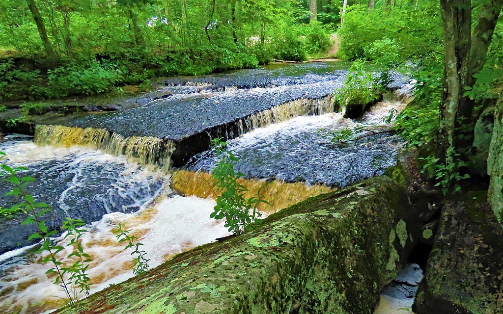
Photo Credits (1)
Difficulty
Moderate
Trail Length
2.4 miles
Trail Type
Out And Back
Elevation Gain
350 ft
About Stepstone Falls
Stepstone Falls is a series of small cascading waterfalls located along the Wood River in the Arcadia Management Area in Rhode Island. It is a serene and picturesque spot, popular for its natural beauty and peaceful surroundings.
The Setting
Stepstone Falls sits at 266 feet within Arcadia Management Area, fed by the Wood River, in the coastal lowlands of Rhode Island.
Trail & Hike Details
The Approach
The moderate 2.4-mile out-and-back trail gains 350 feet of elevation on the way to the falls.
Trail Description
The Ben Utter Trail leading to Stepstone Falls is a relatively flat and easy trail that follows the Wood River. The trail is well-marked and shaded, making it suitable for most visitors, including families. The path features scenic views of the river and surrounding forest.
What to Expect
Dogs are welcome.
Accessibility
The trail is not wheelchair accessible. Uneven terrain and elevation changes require steady footing.
Frequently Asked Questions
🐶 Are Dogs Allowed at Stepstone Falls?
✅ Dogs are allowed
Are There Any Fees or Permits Required?
🆖 No fees required
🏊 Is There Swimming at Stepstone Falls?
❌ Swimming is not allowed
When to Visit
Spring and early summer are ideal times to visit when the water flow is typically higher. Fall offers beautiful foliage, while winter may provide a unique view of the frozen falls.
Seasonal Access
The best time to visit is Spring, Summer, and Fall. Winter access may be limited.
Safety Information
Be cautious of slippery rocks near the falls, especially after rain. Check for ticks after your hike, and avoid the area during hunting season unless wearing bright clothing.
Current Water Conditions
17 ft³/s
Current discharge — how much water is flowing
Much lower than usual for this time of year
Based on 61 years of record
2.64 ft
Water depth at gauge
7-Day Discharge Trend
What does this mean for your visit?
Flow is well below normal for this time of year, so the waterfall may be a trickle.
About This Gauge
7-Day Flow Outlook
Based on the USGS gauge WOOD RIVER NEAR ARCADIA, RI (5 km away).
Today
Moderate
19 cfs
4/10Tomorrow
Moderate
18 cfs
8/10Tue
Low
15 cfs
6/10Wed
Moderate
16 cfs
4/10Thu
Moderate
14 cfs
8/10Fri
Moderate
16 cfs
4/10Sat
Moderate
18 cfs
4/10Best window: Tomorrow — moderate flow, mostly sunny (trip score 8/10).
Best time of year: this gauge typically runs highest from mid February to early May, peaking in April.
How we calculate this
This is a transparent outlook, not a precise forecast. We take the waterfall's current flow strength (how it ranks against its historical normal for today, from the nearest USGS stream gauge), carry that ranking forward along the gauge's seasonal curve, and nudge it for forecast rain. Confidence is highest for the next day or two and falls further out. Always check official conditions and your own judgment before visiting — high flows can be dangerous.
Know when to go.
Get a free email alert when waterfalls near Greene hit peak flow. We only send when conditions are worth the trip — no weekly newsletters, no spam.
Weather Forecast
Location & Access
Getting There
Stepstone Falls is located within the Arcadia Management Area in West Greenwich, Rhode Island. The falls can be accessed via the Ben Utter Trail, which begins near a small parking area off Escoheag Hill Road.
Get Directions on Google MapsParking
There is a small parking area near the trailhead on Escoheag Hill Road. Parking may be limited, especially during peak seasons.
Elevation
266 feet above sea level
Coordinates
41.611766° N, -71.760347° W
Land Management
Managed by UNK
Visitor Tips & Gear
Wear sturdy shoes as the trail may have muddy or uneven sections, especially after rain. Bring bug spray during warmer months to protect against mosquitoes. Arrive early to secure parking, especially on weekends.
As an Amazon Associate, we earn from qualifying purchases.
With 2.4 miles and 350 ft of elevation gain, sturdy boots and trekking poles will help on this moderate trail. Sun exposure on the trail makes good sun protection a must in summer.

Polarized Sunglasses (Knockaround)
Cuts glare off the water so you actually see the falls — and your photos turn out better too.

Columbia Watertight II Rain Jacket
Packs into its own pocket, seam-sealed, and keeps you dry from spray and surprise rain.

Earth Pak Waterproof Dry Bag
Keeps your phone and gear dry when waterfall mist soaks everything else.

Waterproof Phone Pouch (AiRunTech)
Cheap insurance — take photos right next to the falls without killing your phone.

Timberland Euro Sprint Mid Waterproof
Trusted waterproof boot with premium leather and grippy rubber sole — reliable on rocky, wet trails.

TrailBuddy Trekking Poles
Lightweight aluminum, cork grips, and flip-locks that actually hold — a best-seller for good reason.
Where to Stay

La Quinta by Wyndham Norwich-Plainfield-Casino

Bellissimo Hotel, Trademark by Wyndham Near Foxwoods Casino

Hilton Garden Inn Closest Foxwoods

Hyatt Place Uncasville - Casino Area
Browse vacation cabins and private rentals nearby
Unique outdoor stays — tents, yurts, and treehouses
Rent a campervan or RV for your waterfall road trip
Some links are affiliate links. We may earn a commission at no extra cost to you.
Nearby Campground
West Thompson Lake Campground
24.8 miles away · 24 sites
Overview West Thompson Lake Campground is located near the wooded shoreline of its namesake lake in northeastern Connecticut. The natural setting surrounding West Thompson Lake can be enjoyed year round. Visitors come to the lake for camping, fishing, boating, kayaking and hiking.Recreation West Thompson Lake provides great boating, kayaking, canoeing and fishing opportunities. It has an excellent population of warm-water fish, including bass and small panfish. A boat ramp is located near the cam
Book on Recreation.govAdditional Information
Nearby Attractions
Other trails in the Arcadia Management Area, such as the Breakheart Pond Loop, and the nearby Beach Pond.
Wildlife
The area is home to various bird species, deer, and other small wildlife. Be mindful of ticks in the warmer months.
Cities near Stepstone Falls
Writing about Stepstone Falls? Embed this waterfall on your site for free.