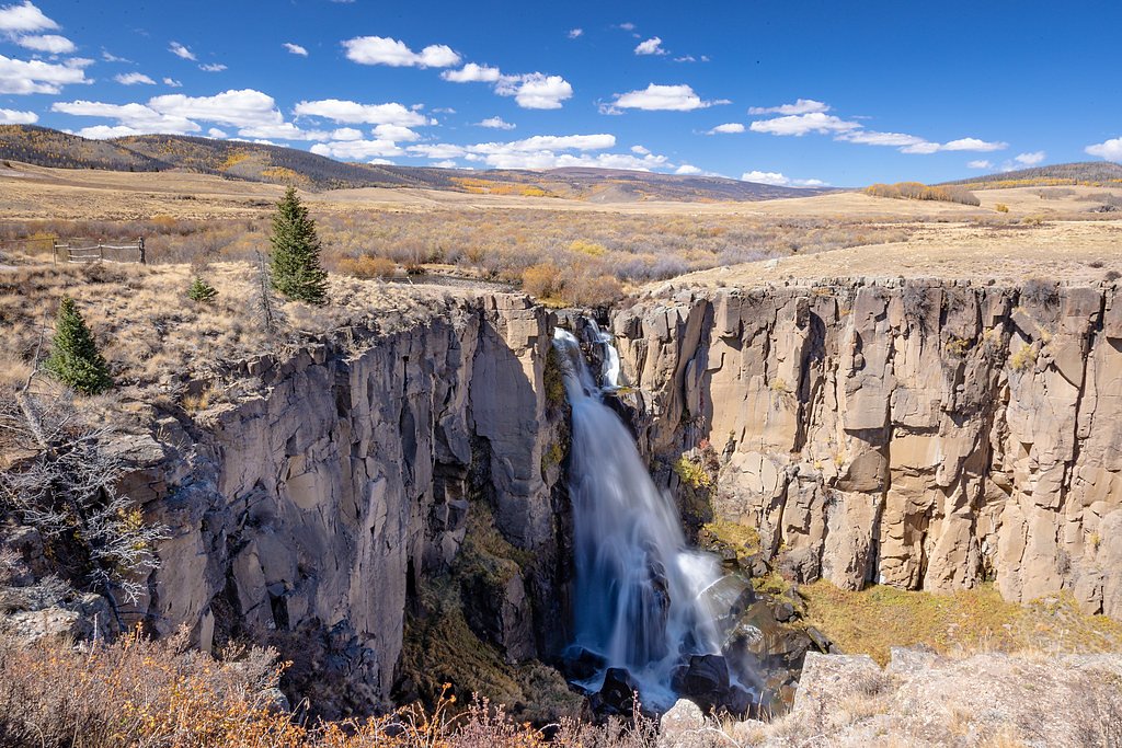
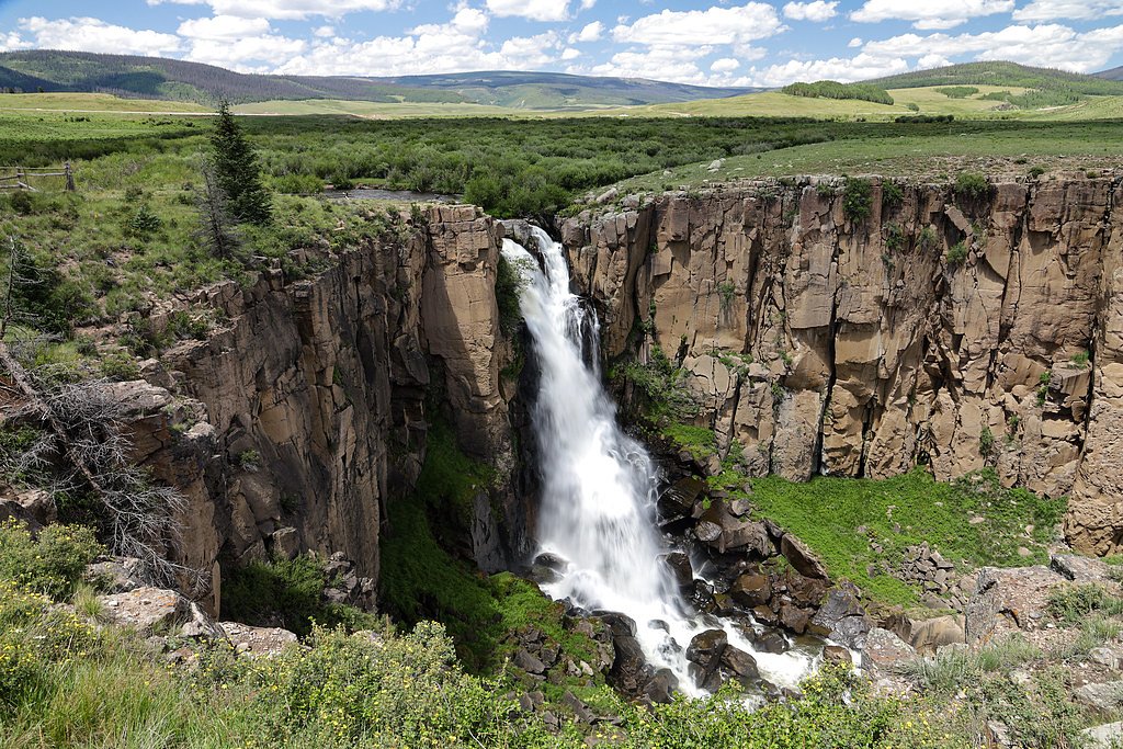
South Clear Creek Falls
Colorado • 30 ft
By Armen Suny · Last verified Mar 2026
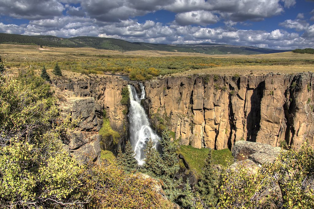
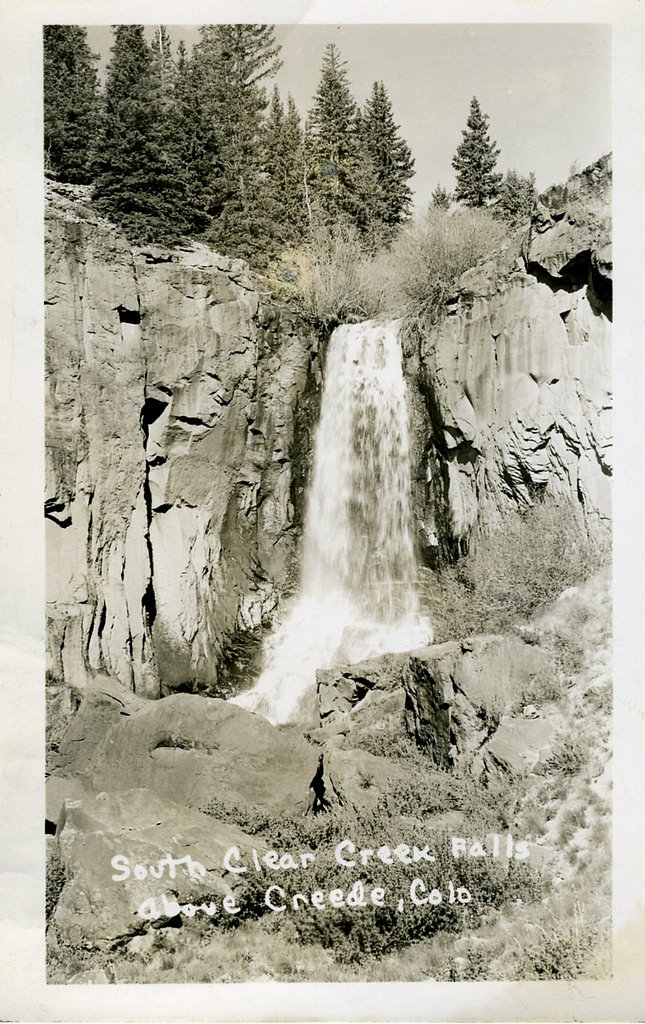
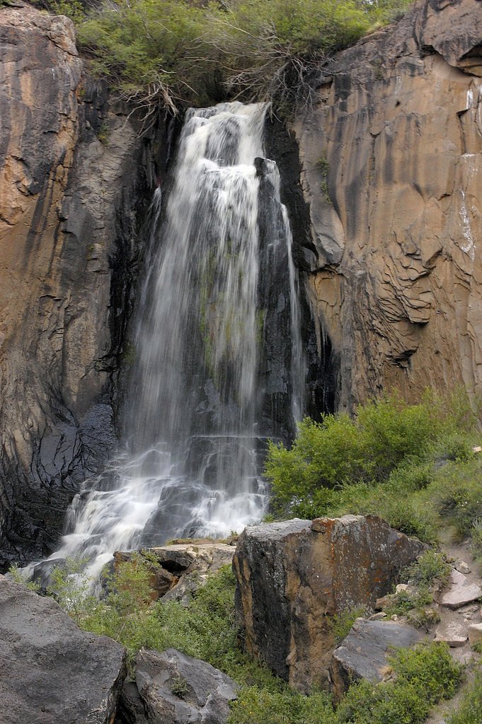
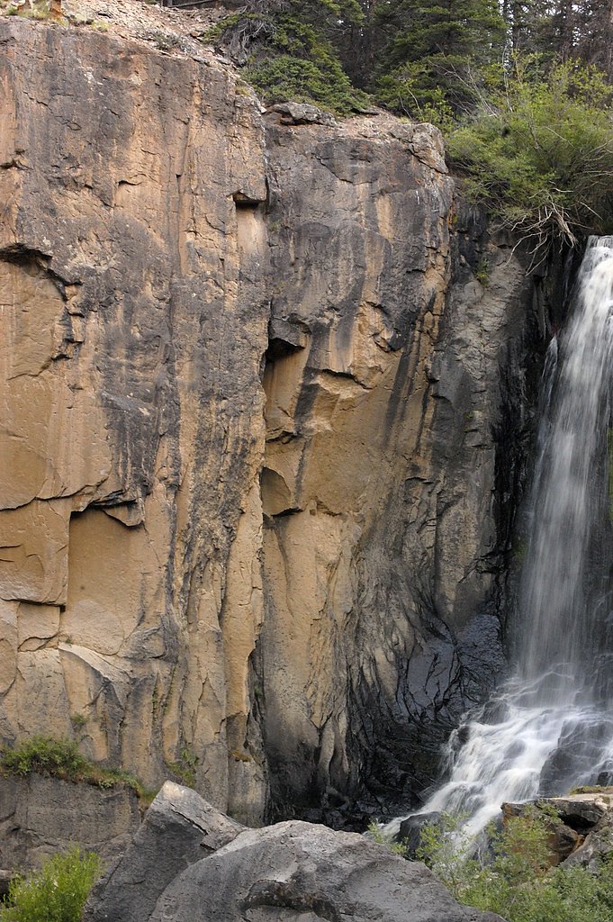
Photo Credits (5)
Difficulty
Moderate
Trail Length
2.4 miles
Trail Type
Out And Back
Elevation Gain
350 ft
About South Clear Creek Falls
South Clear Creek Falls is a welcoming 30-foot cascade tucked into Hinsdale County and managed by the U.S. Forest Service within the Rio Grande National Forest. The falls drop into a rocky canyon framed by evergreen stands and open meadows, making it a favorite quick stop for hikers and photographers exploring the high-country backroads. Bristol Head Campground sits just 1.13 km away, so overnight options are very close if you want to turn the visit into a camp-and-hike outing. The falls sit in the same volcanic landscape that shapes much of Hinsdale County. Nearby North Clear Creek Falls and other local canyons expose Nelson Mountain tuff — solidified volcanic ash from eruptions in the San Juan volcanic field about 27 million years ago — a reminder of the dramatic geologic forces that carved this scenery. The route to South Clear Creek Falls is short enough for most visitors but rewarding enough to feel like a proper alpine stop on a Colorado forest drive.
The Setting
South Clear Creek Falls sits at 9,649 feet within Rio Grande National Forest, fed by the Lake Fork, in the high alpine of Colorado. The falls drop 30 feet.
Height: 30 feet
Nearby Falls Worth Visiting
North Clear Creek Falls (100 ft) lies 1.7 miles to the north.
Trail & Hike Details
The Approach
The moderate hike follows So. Clear Creek (#899), a 2.4-mile out-and-back trail over natural surface. Expect 350 feet of elevation gain with grades of 12-20%. The trail is moderately developed (Class 2).
USFS Trail
SO. CLEAR CREEK #899
Trail Class
Moderately Developed
Surface
Avg Grade
USFS Segment
0.18 miTrail Description
Access to the falls follows the USFS SO. CLEAR CREEK (Trail #899). The USFS records the trail segment at 0.18 GIS miles; the route most hikers report is an out-and-back of about 2.4 miles total with roughly 350 feet of elevation gain and a moderate difficulty rating. Trail surface is NATIVE MATERIAL, the typical grade along the route ranges from 12–20%, and the USFS classifies the trail as Class 2 (Trail #899). Expect a short, well-defined path with native tread that can be steep in sections given the 12–20% grades. The trail is suitable for day hikers who are comfortable with moderate grades and some simple off-trail footing; the nearby Bristol Head Campground (1.13 km away) makes it easy to combine this hike with an overnight stay.
What to Expect
The falls drop 30 feet. Dogs are welcome.
Accessibility
The trail is not wheelchair accessible. Uneven terrain and elevation changes require steady footing.
Frequently Asked Questions
🐶 Are Dogs Allowed at South Clear Creek Falls?
✅ Dogs are allowed
Are There Any Fees or Permits Required?
🆖 No fees required
🏊 Is There Swimming at South Clear Creek Falls?
❌ Swimming is not allowed
When to Visit
The best time to visit is during late spring or early summer when the water flow is at its peak due to snowmelt. Fall also offers beautiful foliage, while winter provides a unique view of the frozen waterfall.
Seasonal Access
The best time to visit is Spring, Summer, and Fall. Access roads and trails may close during winter due to snow. Check with Rio Grande National Forest for seasonal road closures.
Safety Information
Exercise caution near the edge of the viewing platform and stay on designated trails. The rocks near the falls can be slippery, especially after rain or snow.
Current Water Conditions
61 ft³/s
Current discharge — how much water is flowing
Lower than usual for this time of year
Based on 13 years of record
4.40 ft
Water depth at gauge
7-Day Discharge Trend
What does this mean for your visit?
Flow is lower than usual for this time of year.
About This Gauge
This gauge is on a nearby waterway and may not reflect exact conditions at the falls.
7-Day Flow Outlook
Based on the USGS gauge LAKE FORK BLW LAKE SAN CRISTOBAL NR LAKE CITY, CO (21 km away).
Today
Low
63 cfs
6/10Tomorrow
Low
67 cfs
6/10Mon
Low
69 cfs
6/10Tue
Low
69 cfs
6/10Wed
Low
64 cfs
6/10Thu
Low
63 cfs
6/10Fri
Low
60 cfs
6/10Best window: Today — low flow, sunny (trip score 6/10).
Best time of year: this gauge typically runs highest from late April to mid July, peaking in June.
How we calculate this
This is a transparent outlook, not a precise forecast. We take the waterfall's current flow strength (how it ranks against its historical normal for today, from the nearest USGS stream gauge), carry that ranking forward along the gauge's seasonal curve, and nudge it for forecast rain. Confidence is highest for the next day or two and falls further out. Always check official conditions and your own judgment before visiting — high flows can be dangerous.
Know when to go.
Get a free email alert when waterfalls near City of Creede hit peak flow. We only send when conditions are worth the trip — no weekly newsletters, no spam.
Weather Forecast
Location & Access
Getting There
South Clear Creek Falls is located near the Silver Thread Scenic Byway (Highway 149) between Lake City and Creede, Colorado. The falls are accessible via a short drive from the highway, with clear signage directing visitors to the parking area.
Get Directions on Google MapsParking
There is a designated parking area near the trailhead, which is free of charge. The parking lot is typically spacious enough to accommodate visitors, but it may fill up during peak seasons.
Elevation
9,649 feet above sea level
Coordinates
37.825277° N, -107.155885° W
Land Management
Managed by USFS
Visitor Tips & Gear
Visit early in the morning or late in the afternoon to avoid crowds. Wear sturdy shoes as the trail may be uneven in some areas. Bring a camera to capture the stunning views.
This trail sits at 9,649 ft — the air is noticeably thinner
High AltitudeSome visitors experience headaches, fatigue, or shortness of breath at this elevation. Take it slow, stay hydrated, and consider supplemental oxygen if you're coming from a lower altitude.
As an Amazon Associate, we earn from qualifying purchases.

Coppertone Sport SPF 50 Sunscreen
UV intensity jumps ~4% per 1,000 ft — at this elevation you can burn in half the time.

Sun Bum SPF 30 Lip Balm (3-Pack)
Lips have almost no natural UV protection and burn fast in thin, dry mountain air.

Liquid I.V. Electrolyte Packets
You lose moisture ~2x faster at elevation — electrolytes help you absorb water efficiently.

ROCKNIGHT Polarized UV400 Sunglasses
High-altitude glare off rock and water is intense — UV400 lenses block 99%+ of UVA/UVB.

Boost Oxygen 10L Canister (2-Pack)
Portable supplemental oxygen for quick relief from headaches and shortness of breath.

Altitude Rx OxyBoost Complex
Antioxidant formula designed to support your body's natural altitude acclimation.
As an Amazon Associate, we earn from qualifying purchases.
With 2.4 miles and 350 ft of elevation gain, sturdy boots and trekking poles will help on this moderate trail. Sun exposure on the trail makes good sun protection a must in summer.

Polarized Sunglasses (Knockaround)
Cuts glare off the water so you actually see the falls — and your photos turn out better too.

Columbia Watertight II Rain Jacket
Packs into its own pocket, seam-sealed, and keeps you dry from spray and surprise rain.

Earth Pak Waterproof Dry Bag
Keeps your phone and gear dry when waterfall mist soaks everything else.

Waterproof Phone Pouch (AiRunTech)
Cheap insurance — take photos right next to the falls without killing your phone.

Timberland Euro Sprint Mid Waterproof
Trusted waterproof boot with premium leather and grippy rubber sole — reliable on rocky, wet trails.

TrailBuddy Trekking Poles
Lightweight aluminum, cork grips, and flip-locks that actually hold — a best-seller for good reason.
Where to Stay

Quality Inn & Suites South Fork - Wolf Creek

LOGE Wolf Creek

A-Frame Cliffside Studio Cabins

The Spruce Lodge
Browse vacation cabins and private rentals nearby
Unique outdoor stays — tents, yurts, and treehouses
Rent a campervan or RV for your waterfall road trip
Some links are affiliate links. We may earn a commission at no extra cost to you.
Nearby Campground
Bristol Head Campground
0.7 miles away · 0 sites
This campground contains 15 sites (11 are pull through) ranging from 35 to 55 feet in length. There are both dead end spurs and pull throughs. Sits in a meadow on a bench above South Clear Creek. A short trail from campground leads to an overlook of the Clear Creek Canyons and a waterfall. The campground stretches 0.6 mile along a "bench" (a level area) above South Clear Creek. The grassy field between camping sites and creek are dotted with wild flowers. Every site has a view of towering moun
Book on Recreation.govNearby Hot Springs
Hot springs near City of Creede, Colorado
Birdsie Warm Spring
Birdsie Warm Spring reaches 86 degrees Fahrenheit at nearly 9,000 feet elevation near Creede in Mineral County. Located just 15...

Antelope Spring
Antelope Spring emerges at a robust 90 degrees Fahrenheit at 8,950 feet elevation in Mineral County, Colorado, near the histori...

Wagon Wheel Gap Hot Springs
Wagon Wheel Gap Hot Springs emerges at 135 degrees Fahrenheit in the upper Rio Grande River valley near the historic mining tow...

Cebolla Hot Springs
Cebolla Hot Springs emerges at 106 degrees Fahrenheit near Lake City in Hinsdale County at 8,158 feet elevation. The exceptiona...
Rainbow Hot Springs
Rainbow Hot Springs beckons adventurous soakers willing to undertake a substantial backcountry journey in the San Juan Mountain...
Chattanooga Hot Spring
Chattanooga Hot Spring emerges at just 49 degrees Fahrenheit at 10,720 feet elevation near Silverton in San Juan County. Locate...
Looking for a soak after your hike? Explore more hot springs near City of Creede, Colorado on SoakingSprings.
Explore Colorado springsAdditional Information
Nearby Attractions
Nearby attractions include North Clear Creek Falls, the Silver Thread Scenic Byway, and the historic towns of Lake City and Creede.
Wildlife
The area is home to various wildlife, including deer, birds, and small mammals. Visitors should be cautious and avoid feeding or approaching wildlife.
Cities near South Clear Creek Falls
Nearby Waterfalls
Writing about South Clear Creek Falls? Embed this waterfall on your site for free.