
Before you go
The falls are in the San Gorgonio Wilderness with no known trail. A free wilderness permit is required for day hikes and overnight trips, requested through the San Gorgonio Wilderness Association.


Photo Credits (5)
About Silverwood Falls
Silverwood Falls is a named waterfall at about 8,000 feet on the East Fork of the South Fork Whitewater River, roughly 1.5 miles south-southeast of the summit of San Gorgonio Mountain. It lies in the San Gorgonio Wilderness of the San Bernardino National Forest, east-northeast of Oak Glen, and is not near Silverwood Lake, which is more than 30 miles to the northwest. We found no maintained trail or published route to the falls; the nearest mapped trails (Vivian Creek and Sky High) pass more than a mile away.
The Setting
Silverwood Falls sits at 7,976 feet within San Bernardino National Forest, in the high mountains of California.
Trail & Hike Details
USFS Trail
VIVIAN CREEK #1E08.1
Trail Class
Developed
Surface
Avg Grade
USFS Segment
2.90 miAccessibility
The trail to Silverwood Falls is not wheelchair accessible due to uneven terrain and elevation gain.
Frequently Asked Questions
🐶 Are Dogs Allowed at Silverwood Falls?
❌ Dogs are not allowed
Are There Any Fees or Permits Required?
🆖 No fees required
🏊 Is There Swimming at Silverwood Falls?
❌ Swimming is not allowed
When to Visit
The best time to visit Silverwood Falls is during the spring when the waterfall is most likely to be flowing due to snowmelt and rainfall.
Seasonal Access
The best time to visit is Spring, Summer, and Fall. Access roads and trails may close during winter due to snow. Check with San Bernardino National Forest for seasonal road closures.
Safety Information
Be cautious of slippery rocks near the waterfall, especially after rainfall. Watch for wildlife and stay on marked trails to avoid getting lost. Carry sufficient water and be prepared for changing weather conditions.
Know when to go.
Get a free email alert when waterfalls near Oak Glen hit peak flow. We only send when conditions are worth the trip — no weekly newsletters, no spam.
Is Silverwood Falls Frozen?
Updated about 23 hours agoNot frozen highs above freezing lately
Silverwood Falls is not frozen right now; highs have been above freezing. Yesterday ran 58°F to 44°F.
- Days below freezing
- 0 of the last 14
- Current cold streak
- 0 days
- Freezing days ahead
- 0 of the next 7
- Flow
- no gauge
Winter safety. Frozen falls are the one waterfall trip with a documented injury pattern: falling ice, and ice-glazed rock and trail. Wear microspikes, keep well back from the base and from overhangs, and never walk out on ice over moving water.
Estimate from Open-Meteo daily temperatures at the falls, the LiDAR-measured facing direction, and the nearest stream gauge. It is a likelihood, not a report from the trail.
Weather Forecast
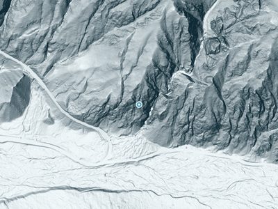
The Terrain, Seen by LiDAR
Aircraft-mounted lasers measured this ground to within inches. Trees and buildings are digitally stripped away, leaving the bare shape of the land the water has carved.
Through the falls the surface drops roughly 311 feet over a short, steep run of tiers. Elevation at the pin is about 7,937 feet.
Steep ground runs through the entire stretch: about 456 feet of descent in the 500 feet above the pin and 244 feet in the 500 feet below it. Facing east, the falls catch soft morning light.
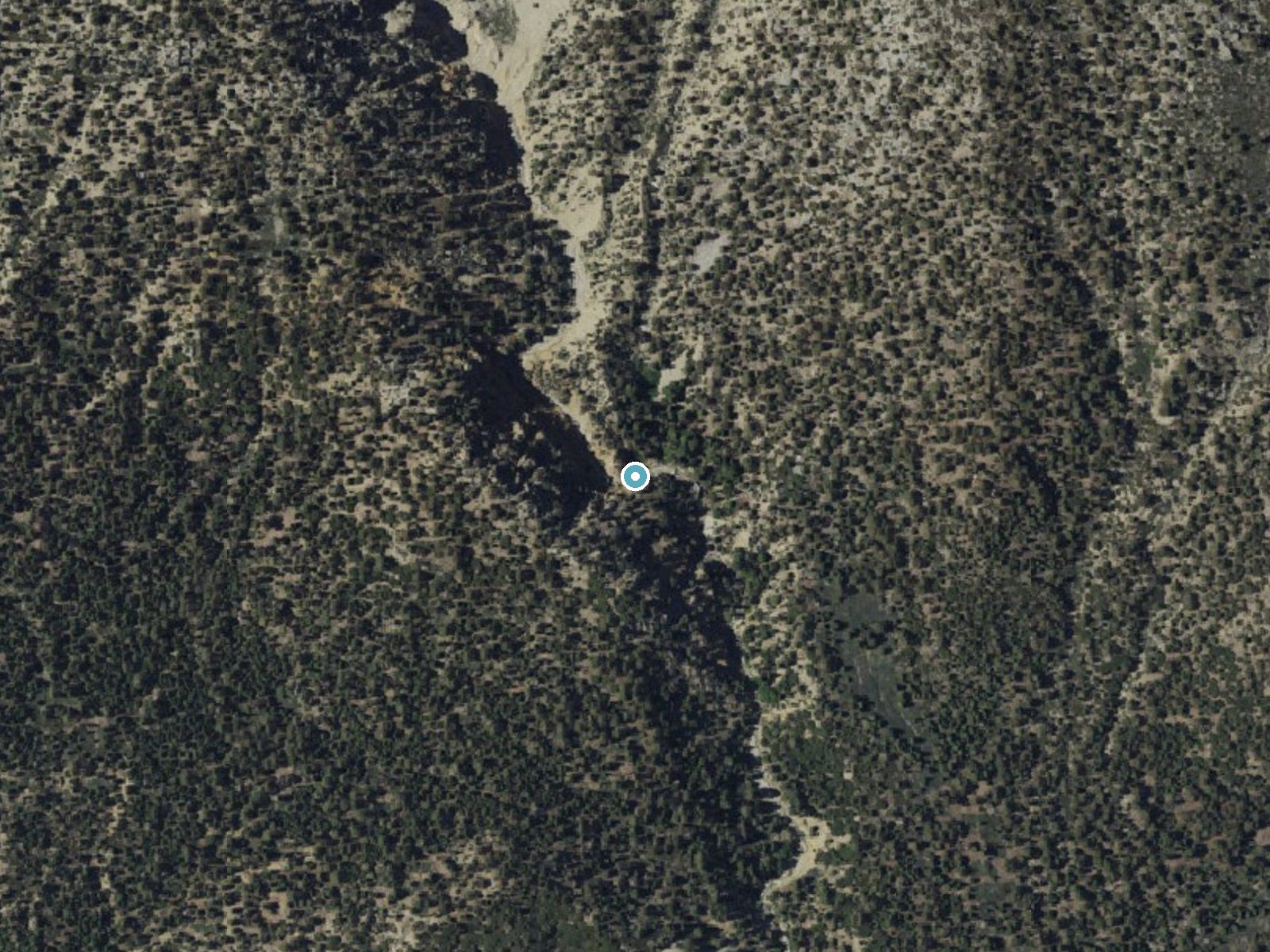
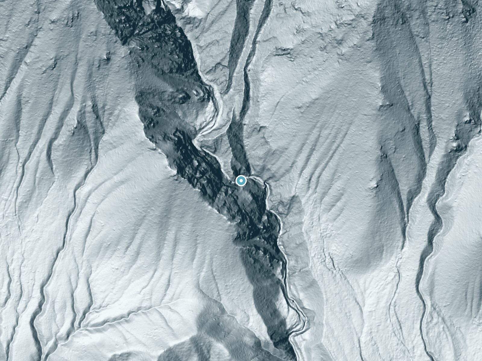
Drag to compare. The dot marks the waterfall. The frame is about a mile across.
- Ground elevation
- 7,937 feet
- Measured by 1-meter lidar
- Drop at the falls
- About 311 feet
- Change in ground height within ~250 feet of the falls
- Faces
- East
- Catches soft morning light.
A slice through the lidar ground surface, from above the falls to downstream (heading east).
Elevation data: USGS 3D Elevation Program. Aerial imagery: USGS The National Map. Public domain.
Location & Access
Elevation
7,976 feet above sea level
Coordinates
34.075604° N, -116.817543° W
Land Management
Managed by USFS Restricted Access
Visitor Tips & Gear
Wear sturdy hiking shoes, as the trail may have uneven or rocky sections. Bring plenty of water, especially during warmer months. Check trail conditions before heading out, as the area may be affected by seasonal closures or weather-related issues.
This trail sits at 7,976 ft above sea level
Elevated TrailUV radiation is roughly 32% stronger at this elevation than at sea level, and the dry air accelerates dehydration. Extra sun protection and fluids go a long way.
As an Amazon Associate, we earn from qualifying purchases.

Coppertone Sport SPF 50 Sunscreen
UV intensity jumps ~4% per 1,000 ft — at this elevation you can burn in half the time.

Sun Bum SPF 30 Lip Balm (3-Pack)
Lips have almost no natural UV protection and burn fast in thin, dry mountain air.

Liquid I.V. Electrolyte Packets
You lose moisture ~2x faster at elevation — electrolytes help you absorb water efficiently.

ROCKNIGHT Polarized UV400 Sunglasses
High-altitude glare off rock and water is intense — UV400 lenses block 99%+ of UVA/UVB.
Where to Stay

Pine Knot Guest Ranch

Lakefront Escape

Hampton Inn Big Bear Lake

Creek Runner's Lodge
Browse vacation cabins and private rentals nearby
Unique outdoor stays — tents, yurts, and treehouses
Rent a campervan or RV for your waterfall road trip
Some links are affiliate links. We may earn a commission at no extra cost to you.
Nearby Campground
Coon Creek Yellow Post Sites
5.9 miles away · 0 sites
These 19 yellow post sites are individual camping sites. Each campsite will be available on a first-come-first-serve basis. No reservations.Each site is limited to a maximum of 8 persons at any one time. There is limited parking at these sites for 2 vehicles. Amenities includes 1 picnic table and 1 fire ring. There are no restroom facilities. There is no drinking water.Campfire permits are required for any type of fire use - campfires, or stoves. Campfires may not be allowed certain times of the
Book on Recreation.govNearby Hot Springs
Hot springs near Idyllwild-Pine Cove, California

Pan Hot Springs
Pan Hot Springs flows at 88 degrees Fahrenheit at 6,717 feet elevation near Big Bear City, creating a 35-degree thermal anomaly...

Highland Springs
Highland Springs produces 112°F water in Riverside County near Cherry Valley, positioned just 16 feet from Canyon Place road at...
Unnamed Spring San Bernardino County
Deep in the San Bernardino National Forest near Mentone, this 90-degree spring flows 26 degrees above ambient in mountains wher...
Soboda Hot Springs
Soboda Hot Springs flows at 102°F in the San Jacinto Valley near San Jacinto, delivering water 36.5 degrees warmer than ambient...
Desert Hot Springs (Thermal Mineral Springs)
Desert Hot Springs encompasses a remarkable geothermal field where approximately 200 geothermal wells have been drilled since 1...
Eden Hot Springs
Eden Hot Springs flows at 109°F from northwestern Riverside County near Lakeview, emerging approximately 44°F warmer than the r...
Looking for a soak after your hike? Explore more hot springs near Idyllwild-Pine Cove, California on SoakingSprings.
Explore California springsAdditional Information
Wildlife
The area is home to a variety of wildlife, including birds, deer, and small mammals. Be cautious of snakes and other potentially hazardous animals.
Cities near Silverwood Falls
Nearby Waterfalls
 LiDAR
Writing about Silverwood Falls? Embed this waterfall on your site for free.