
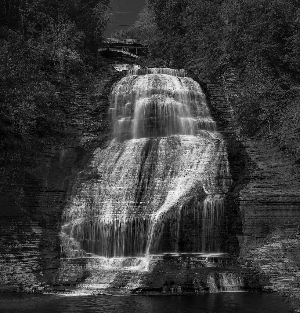
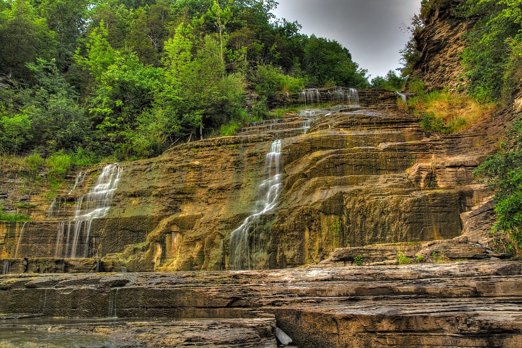
Shequaga Falls
New York • 156 ft
By Armen Suny · Last verified Mar 2026
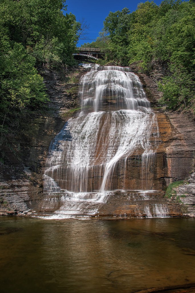
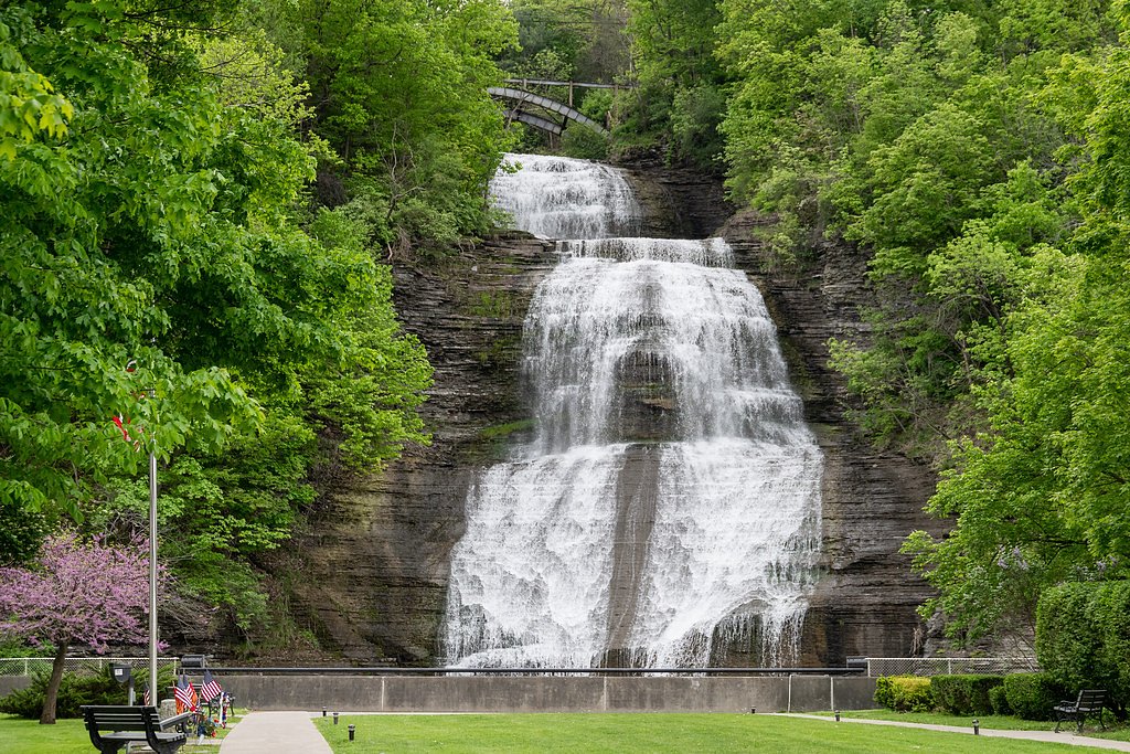
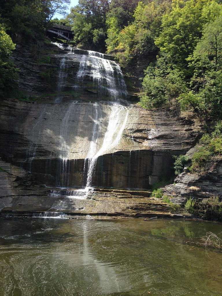
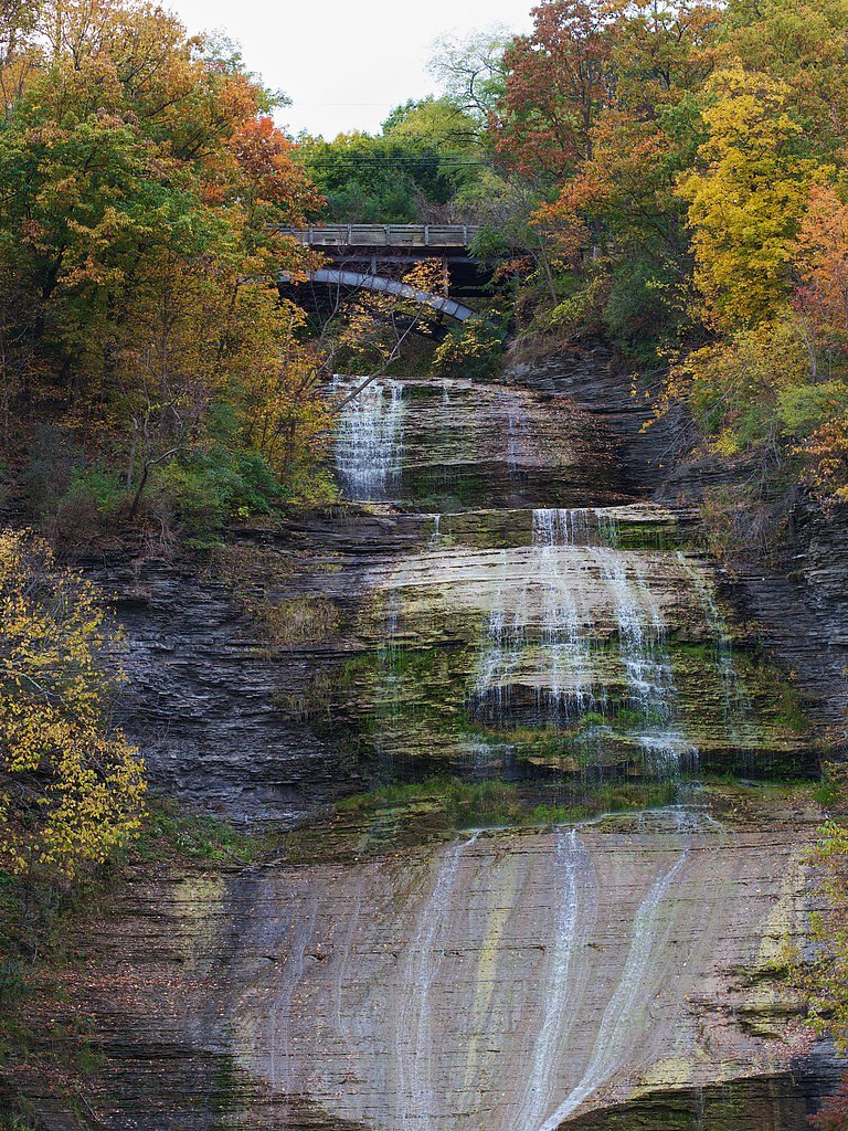

Photo Credits (5)
Difficulty
Moderate
Trail Length
2.4 miles
Trail Type
Out And Back
Elevation Gain
350 ft
About Shequaga Falls
Shequaga Falls is the dramatic 156-foot cascade that spills through the center of Montour Falls, New York, tumbling down a sheer rock face at the end of West Main Street — the very waterfall that gave the village its name. Nestled in the small Schuyler County community (population 2,714 at the 2020 census), the falls are especially photogenic after heavy rains or during the spring thaw. The village name, Montour, honors Queen Catharine Montour, a prominent Seneca woman who once lived at the site, tying the waterfall to the area's deep local history. Access is refreshingly simple: the falls sit in a small roadside park in the heart of town where you can enjoy the view with minimal effort. For visitors who want a little extra time on the trail, local listings note a longer 2.4-mile out-and-back walk that gains about 350 feet and is generally rated moderate — a pleasant option for those who want to stretch their legs and explore the surrounding uplands beyond the village viewpoint.
The Setting
Shequaga Falls sits at 502 feet in the foothills of New York. At 156 feet, it is among the taller waterfalls in New York.
Height: 156 feet
Nearby Falls Worth Visiting
Hector Falls (165 ft) lies 5.1 miles to the north. Also nearby: Aunt Sarahs Falls (90 ft, 0.6 mi).
Trail & Hike Details
The Approach
The moderate 2.4-mile out-and-back trail gains 350 feet of elevation on the way to the falls.
Trail Description
Primary access to Shequaga Falls requires only a short, mostly level walk from roadside parking in the village park; no extended hike is necessary to reach the main overlook. For hikers seeking more distance, a recorded out-and-back route of approximately 2.4 miles (round trip) with about 350 feet of elevation gain is rated moderate and provides a longer outing in the area. Trail surface and official agency trail number are not specified in the available data, so treat the longer route as a local moderate hike rather than a maintained forest-trail system.
What to Expect
The falls plunge 156 feet. Dogs are welcome.
Accessibility
The trail is not wheelchair accessible. Uneven terrain and elevation changes require steady footing.
Frequently Asked Questions
🐶 Are Dogs Allowed at Shequaga Falls?
✅ Dogs are allowed
Are There Any Fees or Permits Required?
🆖 No fees required
🏊 Is There Swimming at Shequaga Falls?
❌ Swimming is not allowed
When to Visit
Spring and early summer are the best times to visit, as the water flow is typically strongest during these seasons.
Seasonal Access
The best time to visit is Spring, Summer, Fall, and Winter.
Safety Information
The area around the falls can be slippery, especially after rain. Stay on designated paths and avoid climbing on rocks near the waterfall.
Current Water Conditions
8 ft³/s
Current discharge — how much water is flowing
Lower than usual for this time of year
Based on 9 years of record
2.70 ft
Water depth at gauge
7-Day Discharge Trend
What does this mean for your visit?
Flow is lower than usual for this time of year.
About This Gauge
7-Day Flow Outlook
Based on the USGS gauge CATHARINE CR AT MONTOUR FALLS NY (2 km away).
Today
Low
9 cfs
3/10Tomorrow
Barely Flowing
8 cfs
5/10Fri
Low
7 cfs
3/10Sat
Low
7 cfs
3/10Sun
Low
7 cfs
3/10Mon
Low
12 cfs
3/10Tue
Low
9 cfs
3/10Best window: Tomorrow — barely flowing flow, sunny (trip score 5/10).
Best time of year: this gauge typically runs highest from late February to early April, peaking in March.
How we calculate this
This is a transparent outlook, not a precise forecast. We take the waterfall's current flow strength (how it ranks against its historical normal for today, from the nearest USGS stream gauge), carry that ranking forward along the gauge's seasonal curve, and nudge it for forecast rain. Confidence is highest for the next day or two and falls further out. Always check official conditions and your own judgment before visiting — high flows can be dangerous.
Know when to go.
Get a free email alert when waterfalls near Montour Falls hit peak flow. We only send when conditions are worth the trip — no weekly newsletters, no spam.
Weather Forecast
Location & Access
Getting There
Shequaga Falls is located in Montour Falls, New York, just off Main Street. It is easily accessible by car and is situated in a small park area within the village.
Get Directions on Google MapsParking
There is a small parking area near the falls, and street parking is also available nearby.
Elevation
502 feet above sea level
Coordinates
42.344796° N, -76.851069° W
Visitor Tips & Gear
Visit after a rainy period for the best water flow. Bring a camera to capture the scenic beauty. The area is small, so plan for a short visit unless exploring the surrounding village.
As an Amazon Associate, we earn from qualifying purchases.
With 2.4 miles and 350 ft of elevation gain, sturdy boots and trekking poles will help on this moderate trail. Icy conditions are common in winter — traction cleats are a smart addition.

Columbia Watertight II Rain Jacket
Packs into its own pocket, seam-sealed, and keeps you dry from spray and surprise rain.

Polarized Sunglasses (Knockaround)
Cuts glare off the water so you actually see the falls — and your photos turn out better too.

Earth Pak Waterproof Dry Bag
Keeps your phone and gear dry when waterfall mist soaks everything else.

Waterproof Phone Pouch (AiRunTech)
Cheap insurance — take photos right next to the falls without killing your phone.

Timberland Euro Sprint Mid Waterproof
Trusted waterproof boot with premium leather and grippy rubber sole — reliable on rocky, wet trails.

TrailBuddy Trekking Poles
Lightweight aluminum, cork grips, and flip-locks that actually hold — a best-seller for good reason.
Where to Stay

The Hotel Laurel at Seneca

Hilton Garden Inn Corning Downtown

Watkins Glen Harbor Hotel

The Anchor Inn
Browse vacation cabins and private rentals nearby
Unique outdoor stays — tents, yurts, and treehouses
Rent a campervan or RV for your waterfall road trip
Some links are affiliate links. We may earn a commission at no extra cost to you.
Nearby Campground
Finger Lakes - Hector District
9.8 miles away · 0 sites
The Finger Lakes National Forest, positioned along the ridges between Cayuga Lake and Seneca Lake, offers scenic beauty and unlimited recreational opportunities any season of the year. Whether you are a hiker, cross country skier, camper, fishing or hunting enthusiast, snowmobiler, horseback rider, mountain biker, or wildlife watcher, the Forest can provide the recreational experience you are seeking!The most popular season is autumn when the trees and pastures are ablaze with color. Hunter ejoy
Book on Recreation.govAdditional Information
Nearby Attractions
Nearby attractions include Watkins Glen State Park, Seneca Lake, and the Finger Lakes Wine Trail.
Wildlife
The area around the falls is urban, so wildlife sightings are minimal, but birds and small mammals may be present.
Cities near Shequaga Falls
Nearby Waterfalls
Writing about Shequaga Falls? Embed this waterfall on your site for free.