

Photo Credits (5)
Difficulty
Drive Up
Trail Length
0.1 miles
Trail Type
Out And Back
Elevation Gain
50 ft
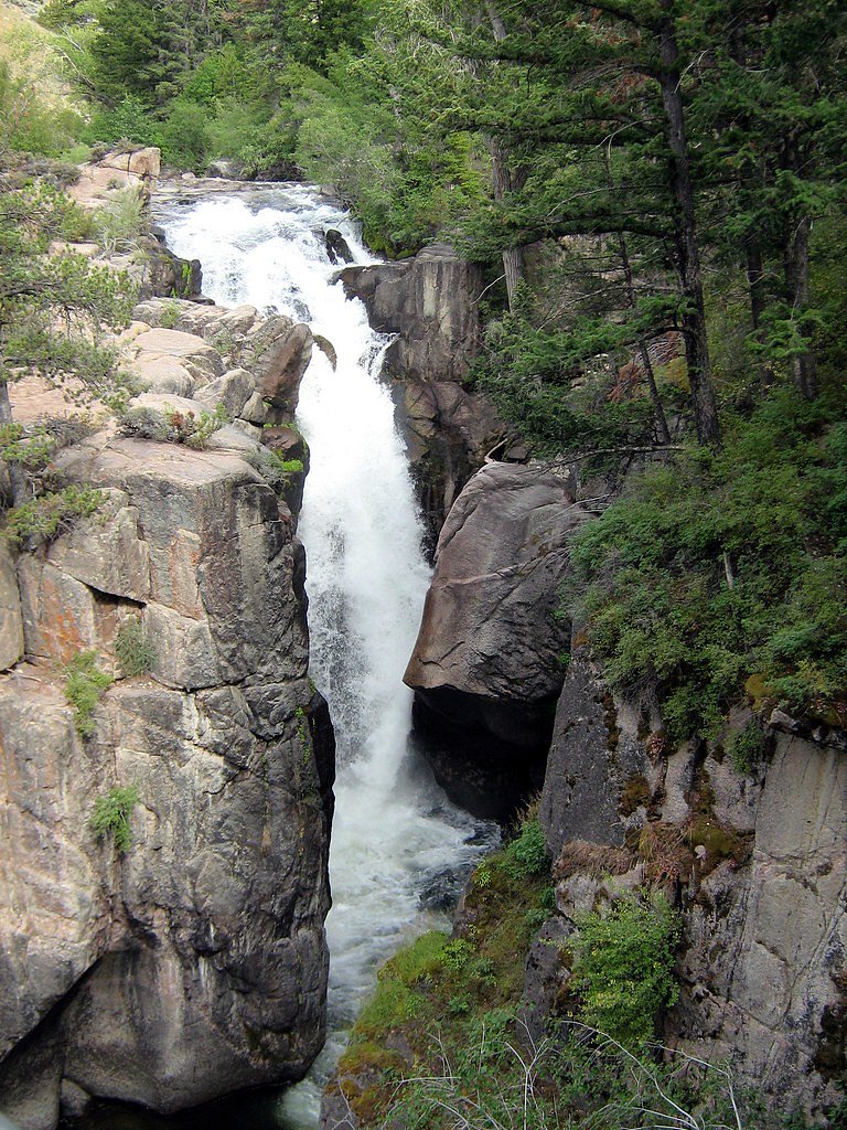
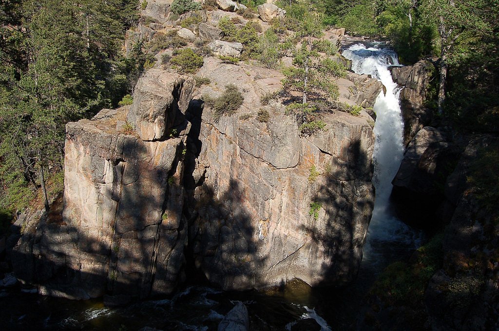
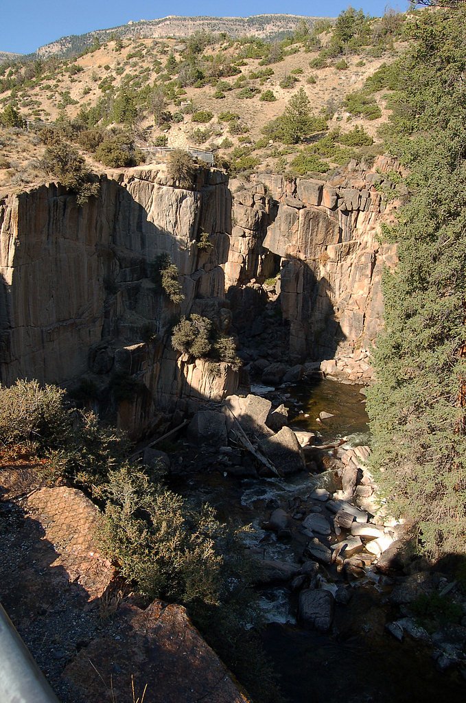
About Shell Falls
Shell Falls is a stunning 120-foot waterfall located in the Bighorn National Forest in Wyoming. It is part of Shell Creek, which flows through Shell Canyon, offering breathtaking views of the surrounding rugged landscape.
The Setting
Shell Falls sits at 6,263 feet within Bighorn National Forest, in the high mountains of Wyoming. At 120 feet, it is among the taller waterfalls in Wyoming.
Height: 120 feet
Trail & Hike Details
The Approach
No hiking required. Shell Falls is accessible by vehicle with a roadside viewing area.
USFS Trail
SHELL BENCH #184
Trail Class
Developed
Surface
Avg Grade
USFS Segment
10.23 miTrail Description
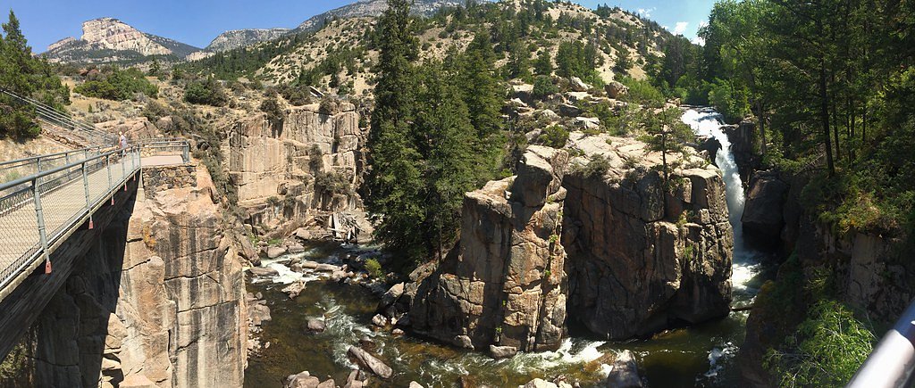
The trail to Shell Falls is a short, paved path that leads to several viewing platforms overlooking the waterfall and Shell Canyon. The trail is well-maintained and suitable for visitors of all ages and abilities.
What to Expect
The falls cascade 120 feet. Dogs are welcome.
Accessibility
This waterfall is viewable from a vehicle-accessible area. No hiking is required.
Frequently Asked Questions
🐶 Are Dogs Allowed at Shell Falls?
✅ Dogs are allowed
Are There Any Fees or Permits Required?
🆖 No fees required
🏊 Is There Swimming at Shell Falls?
❌ Swimming is not allowed
When to Visit
The best time to visit Shell Falls is during the late spring and early summer when the water flow is at its peak due to snowmelt. Fall also offers beautiful foliage in the surrounding area.
Seasonal Access
The best time to visit is Spring, Summer, and Fall. Access roads and trails may close during winter due to snow. Check with Bighorn National Forest for seasonal road closures.
Safety Information
Stay on designated paths and viewing platforms, as the surrounding cliffs and rocks can be slippery and dangerous. Be cautious of changing weather conditions, especially during storms.
Know when to go.
Get a free email alert when waterfalls near Hyattville hit peak flow. We only send when conditions are worth the trip — no weekly newsletters, no spam.
Weather Forecast
Location & Access
Getting There
Shell Falls is located along U.S. Highway 14, also known as the Bighorn Scenic Byway, approximately 21 miles east of Greybull, Wyoming. The falls are easily accessible via a short walk from the parking area.
Get Directions on Google MapsParking
There is a designated parking area at the Shell Falls Interpretive Site, which is well-maintained and suitable for most vehicles.
Elevation
6263 feet above sea level
Coordinates
44.586462° N, -107.612421° W
Land Management
Managed by USFS
Visitor Tips & Gear
Visit early in the day to avoid crowds, especially during the summer months. Bring a camera to capture the stunning views, and wear comfortable shoes for walking on the paved path.
This trail sits at 6,263 ft above sea level
Elevated TrailUV radiation is roughly 25% stronger at this elevation than at sea level, and the dry air accelerates dehydration. Extra sun protection and fluids go a long way.
As an Amazon Associate, we earn from qualifying purchases.

Coppertone Sport SPF 50 Sunscreen
UV intensity jumps ~4% per 1,000 ft — at this elevation you can burn in half the time.

Sun Bum SPF 30 Lip Balm (3-Pack)
Lips have almost no natural UV protection and burn fast in thin, dry mountain air.

Liquid I.V. Electrolyte Packets
You lose moisture ~2x faster at elevation — electrolytes help you absorb water efficiently.

ROCKNIGHT Polarized UV400 Sunglasses
High-altitude glare off rock and water is intense — UV400 lenses block 99%+ of UVA/UVB.
As an Amazon Associate, we earn from qualifying purchases.
For this easy 0.1 miles trail, lightweight trail shoes and a water bottle are usually sufficient. Sun exposure on the trail makes good sun protection a must in summer.

Polarized Sunglasses (Knockaround)
Cuts glare off the water so you actually see the falls — and your photos turn out better too.

Columbia Watertight II Rain Jacket
Packs into its own pocket, seam-sealed, and keeps you dry from spray and surprise rain.

Earth Pak Waterproof Dry Bag
Keeps your phone and gear dry when waterfall mist soaks everything else.

Waterproof Phone Pouch (AiRunTech)
Cheap insurance — take photos right next to the falls without killing your phone.

JOBY GorillaPod Starter Kit
Wraps around railings and rocks for long-exposure waterfall shots — no flat surface needed.

OR Sombriolet Sun Hat
UPF 50+ sun protection with vents so your head doesn't cook on exposed trail sections.
Where to Stay

Shell Campground

Greybull Motel

Wheels Motel

Sage Motel
Browse vacation cabins and private rentals nearby
Unique outdoor stays — tents, yurts, and treehouses
Rent a campervan or RV for your waterfall road trip
Some links are affiliate links. We may earn a commission at no extra cost to you.
Nearby Campground
Ranger Creek Recreation Area
6.2 miles away · 12 sites
Overview Ranger Creek Group Campground is located just off the Bighorn Scenic Byway (U.S. Highway 14) at an elevation of 7,500 feet. The Bighorn National Forest offers a wide variety of activities, including hiking, fishing, scenic driving and a number of historic sites. The administering organization is Gallatin Canyon Campgrounds; e-mail: gccampgrounds13@gmail.comRecreation Scenic off-road driving is available on Battle Creek Road to Medicine Lodge Lake, Ranger Creek Road to Shell Reservoir, Hu
Book on Recreation.govNearby Hot Springs
Hot springs near Hyattville, Wyoming
Sheep Mountain Springs
Sheep Mountain Springs flows at 70 degrees Fahrenheit in Big Horn County at 4,101 feet elevation, accessible via a 386-meter wa...

Little Sheep Mountain Spring
Little Sheep Mountain Spring flows at 68 degrees Fahrenheit at 3,712 feet elevation on Bureau of Land Management land, emerging...
Looking for a soak after your hike? Explore more hot springs near Hyattville, Wyoming on SoakingSprings.
Explore Wyoming springsAdditional Information
Nearby Attractions
Nearby attractions include the Bighorn Scenic Byway, Medicine Wheel National Historic Landmark, and the town of Greybull.
Wildlife
The area around Shell Falls is home to a variety of wildlife, including deer, elk, and birds of prey. Visitors may also spot smaller animals like marmots and chipmunks.
Cities near Shell Falls
Writing about Shell Falls? Embed this waterfall on your site for free.