
Service Falls
Washington • Olympic National Park
By Armen Suny · Last verified Oct 2026
3D terrainBefore you go
No trail reaches this waterfall. It lies in the remote upper Queets basin of Olympic National Park and requires off-trail backcountry travel and a wilderness permit for overnight stays.


Photo Credits (5)
About Service Falls
Service Falls is on the upper Queets River in the interior of Olympic National Park, below the Jeffers Glacier on the south side of the Mount Olympus massif. No maintained trail reaches it; the nearest mapped trail is several miles away, so seeing it means a multi-day, off-trail wilderness trip.
The Setting
Service Falls sits at 1,975 feet within Olympic National Park, in the hills of Washington.
Trail & Hike Details
Accessibility
Not accessible; there is no trail.
Frequently Asked Questions
🐶 Are Dogs Allowed at Service Falls?
❌ Dogs are not allowed
Pets are not allowed on Olympic National Park trails or in its wilderness, except on six short designated trails.
Are There Any Fees or Permits Required?
🆖 No fees required
🏊 Is There Swimming at Service Falls?
❌ Swimming is not allowed
When to Visit
Seasonal Access
The best time to visit is Spring, Summer, and Fall. Winter access may be limited. Check with Olympic National Park for current conditions.
Safety Information
Remote, trailless terrain with river crossings, snowfields and no cell service. Rescue can take a long time.
Current Water Conditions
These readings come from the USGS gauge on Elwha River, 20.8 miles away, not on Service Falls's own stream. Use them as a sign of whether the area is running wet or dry.
3,020 ft³/s
Current discharge — how much water is flowing
Higher than usual for this time of year
Based on 113 years of record
11.99 ft
Water depth at gauge
7-Day Discharge Trend
What does this mean for your visit?
The water is flowing higher than usual for this time of year.
About This Gauge
This gauge is on a regional waterway. Conditions at the falls may differ, especially after local rain.
7-Day Flow Outlook
Based on the USGS gauge ELWHA RIVER AT MCDONALD BR NEAR PORT ANGELES, WA (34 km away).
Today
Roaring
3812 cfs
6/10Tomorrow
Roaring
3824 cfs
6/10Fri
Roaring
4148 cfs
6/10Sat
Roaring
4537 cfs
6/10Sun
Roaring
4018 cfs
6/10Mon
Roaring
4213 cfs
6/10Tue
Roaring
4440 cfs
6/10Best window: Today — roaring flow, rain (trip score 6/10).
Best time of year: this gauge typically runs highest from early May to early July, peaking in June.
How we calculate this
This is a transparent outlook, not a precise forecast. We take the waterfall's current flow strength (how it ranks against its historical normal for today, from the nearest USGS stream gauge), carry that ranking forward along the gauge's seasonal curve, and nudge it for forecast rain. Confidence is highest for the next day or two and falls further out. Always check official conditions and your own judgment before visiting — high flows can be dangerous.
Know when to go.
Get a free email alert when waterfalls near Amanda Park hit peak flow. We only send when conditions are worth the trip — no weekly newsletters, no spam.
Is Service Falls Frozen?
Updated about 4 hours agoNot frozen highs above freezing lately big river, rarely freezes solid
Service Falls is not frozen right now; highs have been above freezing. Yesterday ran 51°F to 40°F.
- Days below freezing
- 0 of the last 14
- Current cold streak
- 0 days
- Freezing days ahead
- 0 of the next 7
- Flow
- 3770 ft³/s
Winter safety. Frozen falls are the one waterfall trip with a documented injury pattern: falling ice, and ice-glazed rock and trail. Wear microspikes, keep well back from the base and from overhangs, and never walk out on ice over moving water.
Estimate from Open-Meteo daily temperatures at the falls, the LiDAR-measured facing direction, and the nearest stream gauge. It is a likelihood, not a report from the trail. See every frozen waterfall in Washington.
Weather Forecast
The Terrain Around Service Falls
High-resolution lidar hasn't been flown here yet, so this is the aerial view of the ground around the falls. Open the 3D view to tilt and spin the landscape.
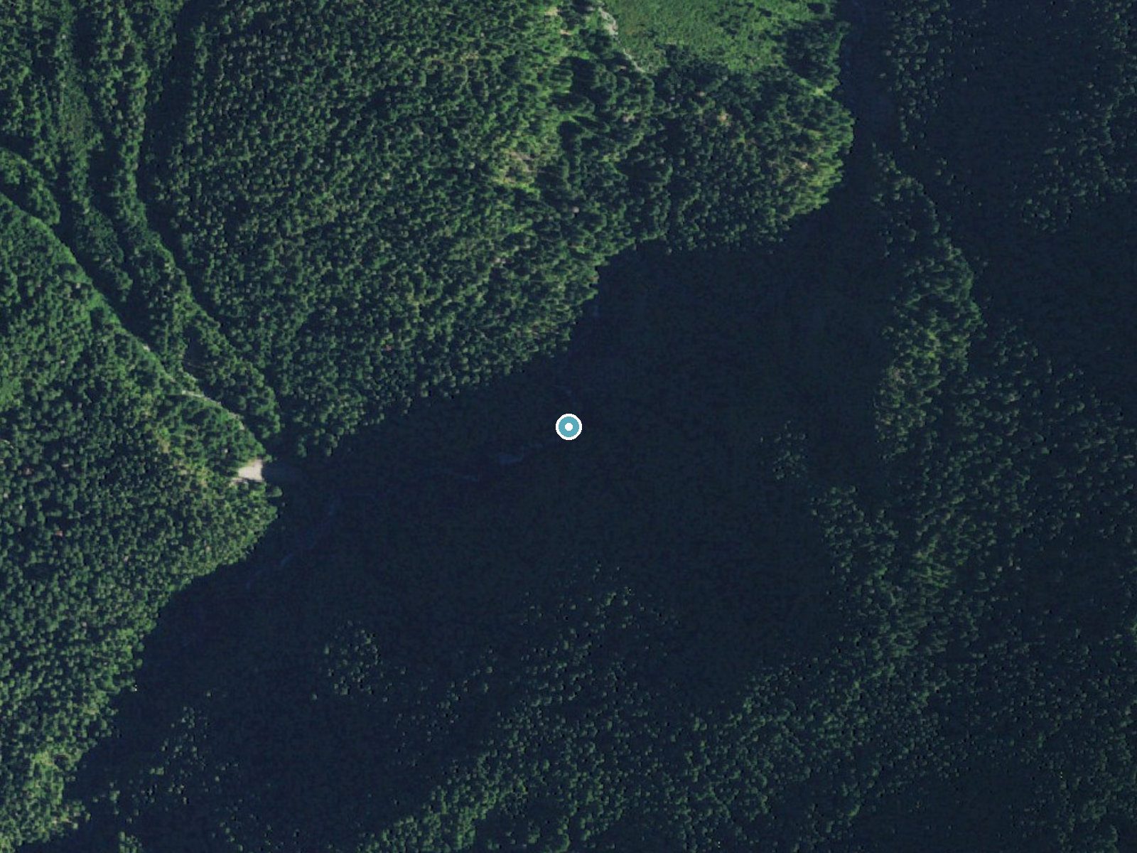
The dot marks the waterfall. The frame is about a mile across.
Aerial imagery: USGS The National Map. Public domain.
Location & Access
Getting There
There is no trailhead for the falls. The upper Queets basin is reached only by experienced backcountry travelers on multi-day, largely off-trail routes. Contact the Olympic National Park Wilderness Information Center before planning a trip.
Get Directions on Google MapsElevation
1,975 feet above sea level
Coordinates
47.757486° N, -123.658767° W
Land Management
Managed by NPS
Visitor Tips & Gear
Wilderness permits are required for overnight stays in Olympic National Park. This area demands navigation skills and glacier-country experience.
Where to Stay

Sol Duc Hot Springs Resort

Lake Quinault Lodge
Woodstone Cabin

Serene & Luxury Retreat, Waterfront, Hot tub, Clamming
Browse vacation cabins and private rentals nearby
Unique outdoor stays — tents, yurts, and treehouses
Rent a campervan or RV for your waterfall road trip
Some links are affiliate links. We may earn a commission at no extra cost to you.
Nearby Campground
Hoh Rainforest Campground
14.6 miles away · 89 sites
Overview The reservation season for the 2026 summer season for the Hoh campground is June 12, 2026 - September 6, 2026.Important information about booking windows: To better serve visitors, Hoh Campground will be releasing campsites in a series of three staggered block releases by loop. These block releases will be 6 months in advance, two weeks in advance, and 4 days in advance. • A loop campsites will be available for reservation 6 months in advance.• C loop campsites will be available for res
Book on Recreation.govNearby Hot Springs
Hot springs near Brinnon, Washington

Olympic Hot Springs
Olympic Hot Springs flows at 118 degrees within Olympic National Park at 2,000 feet elevation, emerging 72 degrees above ambien...

Sol Duc Hot Springs
Sol Duc Hot Springs flows at 122 degrees Fahrenheit in Olympic National Park with permanently protected Class 1 status under Na...
Looking for a soak after your hike? Explore more hot springs near Brinnon, Washington on SoakingSprings.
Explore Washington springsAdditional Information
Cities near Service Falls
Writing about Service Falls? Embed this waterfall on your site for free.