Rust Falls
By Armen Suny · Last verified May 2026
Difficulty
Moderate
Trail Length
2.4 miles
Trail Type
Out And Back
Elevation Gain
350 ft
About Rust Falls
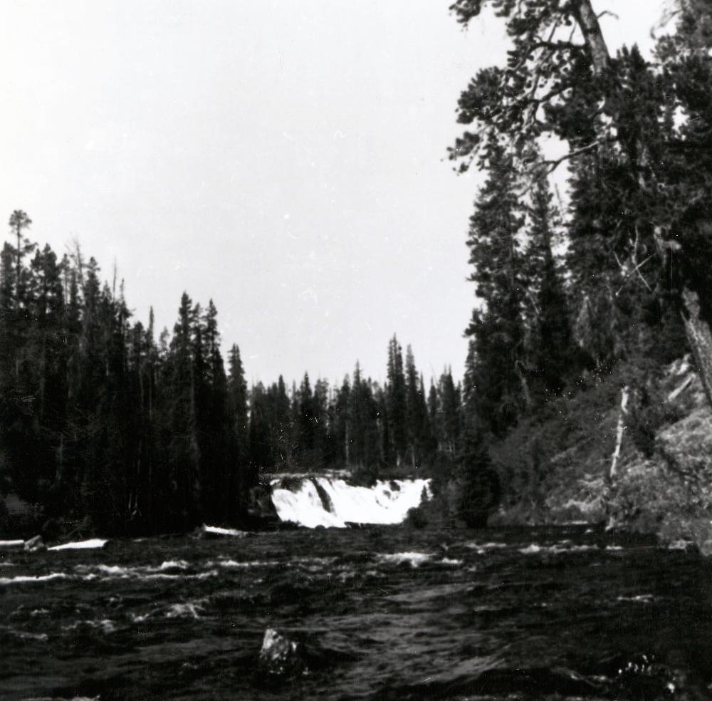
Rust Falls is a lesser-known waterfall tucked into the Canyon Lake land unit (land owner: DESG) and managed by the U.S. Army Corps of Engineers (USACE) as a recreation (REC) area. The falls sit in a quiet, natural setting framed by native Texas vegetation; water flow can vary with recent rainfall, so the most dramatic cascades typically follow wet periods. Its low profile and scenic surroundings make Rust Falls a rewarding destination for hikers who prefer a more solitary outdoor experience. Access to the falls is via a roughly 2.4-mile out-and-back trail that climbs about 350 feet and is rated moderate — sturdy shoes and water are recommended. If you plan to camp, Cranes Mill Park campground is nearby (~7.5 km / 4.7 mi away) and is part of the same Canyon Lake recreation system managed by USACE, making overnight options convenient for multi-day trips. As this site is within a managed recreation unit, please follow posted rules and practice leave-no-trace principles to help preserve the area.
The Setting
Rust Falls sits at 938 feet within Canyon Lake, in the foothills of Texas.
Trail & Hike Details
The Approach
The moderate 2.4-mile out-and-back trail gains 350 feet of elevation on the way to the falls.
Trail Description
Trail type: out-and-back. Length: 2.4 miles (round-trip). Elevation gain: ~350 feet. Difficulty: moderate. Official USFS trail name/number is not listed for this route, and specific surface, grade, and technical trail class details are not documented by the managing agencies; hikers should generally expect a natural dirt tread with some steeper sections and uneven footing. Trail conditions and the volume of water at the falls vary with recent rainfall, so check local conditions before heading out and bring adequate water, sun protection, and sturdy footwear.
What to Expect
Visitors can expect a peaceful natural environment with the possibility of seasonal water flow. The area may be remote and less developed, so preparation is key.
Accessibility
The trail is not wheelchair accessible. Uneven terrain and elevation changes require steady footing.
Frequently Asked Questions
🐶 Are Dogs Allowed at Rust Falls?
❌ Dogs are not allowed
Are There Any Fees or Permits Required?
🆖 No fees required
🏊 Is There Swimming at Rust Falls?
❌ Swimming is not allowed
When to Visit
Spring and after periods of rainfall are typically the best times to visit, as the waterfall may be dry during drier months.
Seasonal Access
The best time to visit is Spring, Summer, and Fall. Winter access may be limited.
Safety Information
Visitors should be cautious of uneven terrain, potential wildlife encounters, and seasonal water flow. Always inform someone of your plans before visiting remote areas.
Current Water Conditions
1,260 ft³/s
Current discharge — how much water is flowing
Much higher than usual for this time of year
Based on 104 years of record
5.07 ft
Water depth at gauge
7-Day Discharge Trend
What does this mean for your visit?
The water is flowing much higher than usual, expect an impressive display.
About This Gauge
7-Day Flow Outlook
Based on the USGS gauge Guadalupe Rv nr Spring Branch, TX (3 km away).
Today
Low
1280 cfs
6/10Tomorrow
Low
1280 cfs
6/10Thu
Low
1292 cfs
6/10Fri
Low
1292 cfs
6/10Sat
Low
1206 cfs
6/10Sun
Low
1255 cfs
6/10Mon
Low
1231 cfs
6/10Best window: Today — low flow, sunny (trip score 6/10).
Best time of year: this gauge typically runs highest from mid April to mid June, peaking in May.
How we calculate this
This is a transparent outlook, not a precise forecast. We take the waterfall's current flow strength (how it ranks against its historical normal for today, from the nearest USGS stream gauge), carry that ranking forward along the gauge's seasonal curve, and nudge it for forecast rain. Confidence is highest for the next day or two and falls further out. Always check official conditions and your own judgment before visiting — high flows can be dangerous.
Know when to go.
Get a free email alert when waterfalls near Spring Branch hit peak flow. We only send when conditions are worth the trip — no weekly newsletters, no spam.
Weather Forecast
Location & Access
Getting There
Specific directions to Rust Falls are not widely documented. It is recommended to consult local resources or park officials for accurate guidance.
Get Directions on Google MapsParking
Parking availability is unclear. Visitors should prepare for limited or informal parking options near the trailhead.
Elevation
938 feet above sea level
Coordinates
29.884661° N, -98.370572° W
Land Management
Managed by USACE
Visitor Tips & Gear
Bring plenty of water, wear sturdy footwear, and check weather conditions before visiting. Cell service may be limited in the area.
As an Amazon Associate, we earn from qualifying purchases.
With 2.4 miles and 350 ft of elevation gain, sturdy boots and trekking poles will help on this moderate trail. Sun exposure on the trail makes good sun protection a must in summer.

Columbia Watertight II Rain Jacket
Packs into its own pocket, seam-sealed, and keeps you dry from spray and surprise rain.

Earth Pak Waterproof Dry Bag
Keeps your phone and gear dry when waterfall mist soaks everything else.

Waterproof Phone Pouch (AiRunTech)
Cheap insurance — take photos right next to the falls without killing your phone.

Timberland Euro Sprint Mid Waterproof
Trusted waterproof boot with premium leather and grippy rubber sole — reliable on rocky, wet trails.

TrailBuddy Trekking Poles
Lightweight aluminum, cork grips, and flip-locks that actually hold — a best-seller for good reason.

Polarized Sunglasses (Knockaround)
Cuts glare off the water so you actually see the falls — and your photos turn out better too.
Where to Stay

Tres A Lake Retreat

Baby Owl Lakehouse

Hampton Inn By Hilton Bulverde Texas Hill Country

On Top of the World
Browse vacation cabins and private rentals nearby
Unique outdoor stays — tents, yurts, and treehouses
Rent a campervan or RV for your waterfall road trip
Some links are affiliate links. We may earn a commission at no extra cost to you.
Nearby Campground
CRANES MILL PARK
4.7 miles away · 64 sites
Overview Cranes Mill Park is located on a long peninsula on the southwestern shore of Canyon Lake in Texas Hill Country, halfway between Austin and San Antonio. Dramatic sunrises to the east of the park across Canyon Lake and sunsets on the western side of the park behind the Guadalupe River make this an unforgettable location.Recreation Cranes Mill Park offers a ramp for boating and two fishing piers. The Canyon Lake area has many options for recreation including: helicopter tours, boating, kaya
Book on Recreation.govNearby Hot Springs
Hot springs near Spring Branch, Texas
Looking for a soak after your hike? Explore more hot springs near Spring Branch, Texas on SoakingSprings.
Explore Texas springsAdditional Information
Nearby Attractions
Nearby attractions are not well-documented. Visitors may explore other natural areas or parks in the region.
Wildlife
The area may host typical Texas wildlife, including birds, small mammals, and insects. Be cautious of snakes and other potentially hazardous animals.
Cities near Rust Falls
Nearby Waterfalls
Writing about Rust Falls? Embed this waterfall on your site for free.