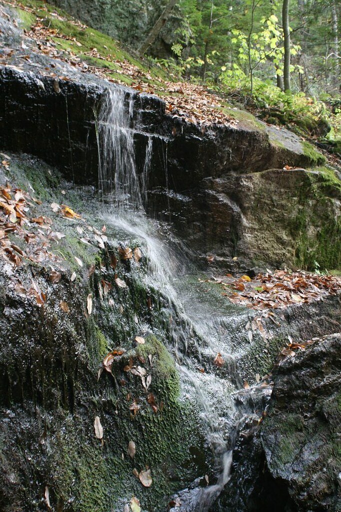
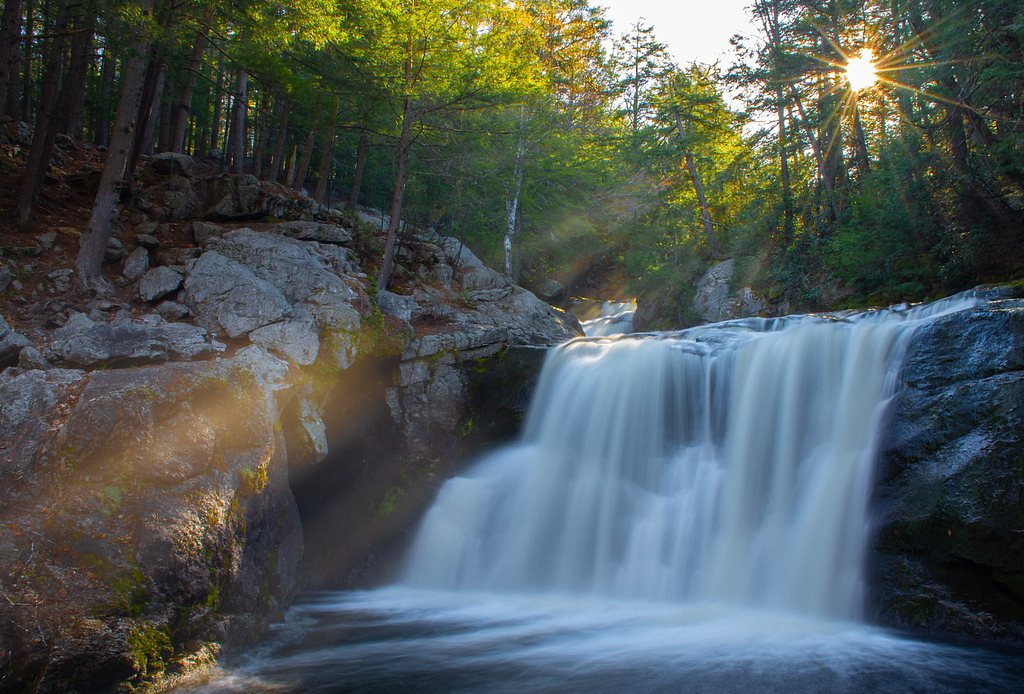
Royalston Falls
Massachusetts • 45 ft
By Armen Suny · Last verified May 2026
Photo Credits (2)
Difficulty
Moderate
Trail Length
2.5 miles
Trail Type
Out And Back
Elevation Gain
200 ft
About Royalston Falls
Royalston Falls is a picturesque waterfall located in Royalston, Massachusetts. It features a dramatic 45-foot drop into a gorge surrounded by lush forest, making it a popular destination for nature enthusiasts and hikers.
The Setting
Royalston Falls sits at 856 feet within Royalston Falls, fed by the East Branch Tully River, in the foothills of Massachusetts. The falls drop 45 feet.
Height: 45 feet
Trail & Hike Details
The Approach
The moderate 2.5-mile out-and-back trail gains 200 feet of elevation on the way to the falls.
Trail Description
The trail to Royalston Falls is a moderately challenging out-and-back hike through a dense forest. The path is well-marked but may have uneven terrain and muddy sections, especially after rain. The trail follows the Tully Trail for part of the way and leads to a viewing area overlooking the waterfall.
What to Expect
The falls drop 45 feet. Dogs are welcome.
Accessibility
The trail is not wheelchair accessible. Uneven terrain and elevation changes require steady footing.
Frequently Asked Questions
🐶 Are Dogs Allowed at Royalston Falls?
✅ Dogs are allowed
Are There Any Fees or Permits Required?
🆖 No fees required
🏊 Is There Swimming at Royalston Falls?
❌ Swimming is not allowed
When to Visit
Spring and early summer are the best times to visit, as the waterfall is most active during these seasons. Fall offers beautiful foliage, while winter may provide a unique view of the frozen falls.
Seasonal Access
The best time to visit is Spring, Summer, and Fall. Winter access may be limited.
Safety Information
Exercise caution near the edge of the gorge, as the rocks can be slippery. Avoid visiting during heavy rain or icy conditions, as the trail may become hazardous.
Current Water Conditions
24 ft³/s
Current discharge — how much water is flowing
About average for this time of year
2.83 ft
Water depth at gauge
7-Day Discharge Trend
What does this mean for your visit?
Flow is about average for this time of year.
About This Gauge
This gauge is on a nearby waterway and may not reflect exact conditions at the falls.
7-Day Flow Outlook
Based on the USGS gauge EAST BRANCH TULLY RIVER NEAR ATHOL, MA (8 km away).
Today
Moderate
24 cfs
8/10Tomorrow
Moderate
24 cfs
8/10Tue
Moderate
28 cfs
4/10Wed
Moderate
26 cfs
8/10Thu
Moderate
24 cfs
8/10Fri
Moderate
28 cfs
4/10Sat
Moderate
29 cfs
4/10Best window: Today — moderate flow, mostly sunny (trip score 8/10).
How we calculate this
This is a transparent outlook, not a precise forecast. We take the waterfall's current flow strength (how it ranks against its historical normal for today, from the nearest USGS stream gauge), carry that ranking forward along the gauge's seasonal curve, and nudge it for forecast rain. Confidence is highest for the next day or two and falls further out. Always check official conditions and your own judgment before visiting — high flows can be dangerous.
Know when to go.
Get a free email alert when waterfalls near West Swanzey hit peak flow. We only send when conditions are worth the trip — no weekly newsletters, no spam.
Weather Forecast
Location & Access
Getting There
Royalston Falls is located within the Royalston Falls Reservation, managed by The Trustees of Reservations. The trailhead can be accessed via Falls Road in Royalston, Massachusetts.
Get Directions on Google MapsParking
Parking is available at the trailhead on Falls Road. The parking area is small, so arriving early is recommended, especially on weekends.
Elevation
856 feet above sea level
Coordinates
42.714529° N, -72.245362° W
Land Management
Managed by UNK
Visitor Tips & Gear
Wear sturdy hiking shoes as the trail can be uneven and muddy. Bring insect repellent during warmer months to protect against mosquitoes. Arrive early to secure parking and enjoy a quieter experience.
As an Amazon Associate, we earn from qualifying purchases.
With 2.5 miles and 200 ft of elevation gain, sturdy boots and trekking poles will help on this moderate trail. Sun exposure on the trail makes good sun protection a must in summer.

Polarized Sunglasses (Knockaround)
Cuts glare off the water so you actually see the falls — and your photos turn out better too.

Columbia Watertight II Rain Jacket
Packs into its own pocket, seam-sealed, and keeps you dry from spray and surprise rain.

Earth Pak Waterproof Dry Bag
Keeps your phone and gear dry when waterfall mist soaks everything else.

Waterproof Phone Pouch (AiRunTech)
Cheap insurance — take photos right next to the falls without killing your phone.

Timberland Euro Sprint Mid Waterproof
Trusted waterproof boot with premium leather and grippy rubber sole — reliable on rocky, wet trails.

TrailBuddy Trekking Poles
Lightweight aluminum, cork grips, and flip-locks that actually hold — a best-seller for good reason.
Where to Stay

Blooming Inn Shelburne Falls

Vikings Villages Resort

Riverside Hotel, an Ascend Collection Hotel

Old Mill Inn
Browse vacation cabins and private rentals nearby
Unique outdoor stays — tents, yurts, and treehouses
Rent a campervan or RV for your waterfall road trip
Some links are affiliate links. We may earn a commission at no extra cost to you.
Nearby Campground
TULLY LAKE RECREATION AREA (MA)
5.1 miles away · 1 sites
Overview The U.S. Army Corps of Engineers invites you to come relax at Tully Lake. There are a variety of outdoor recreation activities for you and you family. Although the dam was built primarily to reduce flood damages on the Millers and Connecticut Rivers, the 1,300-acre reservoir area provides a place for you to get away from it all and connect with nature.Recreation Tully Lake offers many opportunities to enjoy the outdoors. Activities in and around the lake include mountain biking, camping,
Book on Recreation.govNearby Hot Springs
Hot springs near West Swanzey, Massachusetts
Looking for a soak after your hike? Explore more hot springs near West Swanzey, Massachusetts on SoakingSprings.
Explore Massachusetts springsAdditional Information
Nearby Attractions
Nearby attractions include the Tully Lake Recreation Area and Doane's Falls, both offering additional hiking and scenic views.
Wildlife
The area is home to various wildlife, including birds, deer, and small mammals. Keep an eye out for salamanders near the streams.
Cities near Royalston Falls
Nearby Waterfalls
Writing about Royalston Falls? Embed this waterfall on your site for free.