
Photo Credits (5)
Difficulty
Moderate
Trail Length
1.5 miles
Trail Type
Loop
Elevation Gain
200 ft
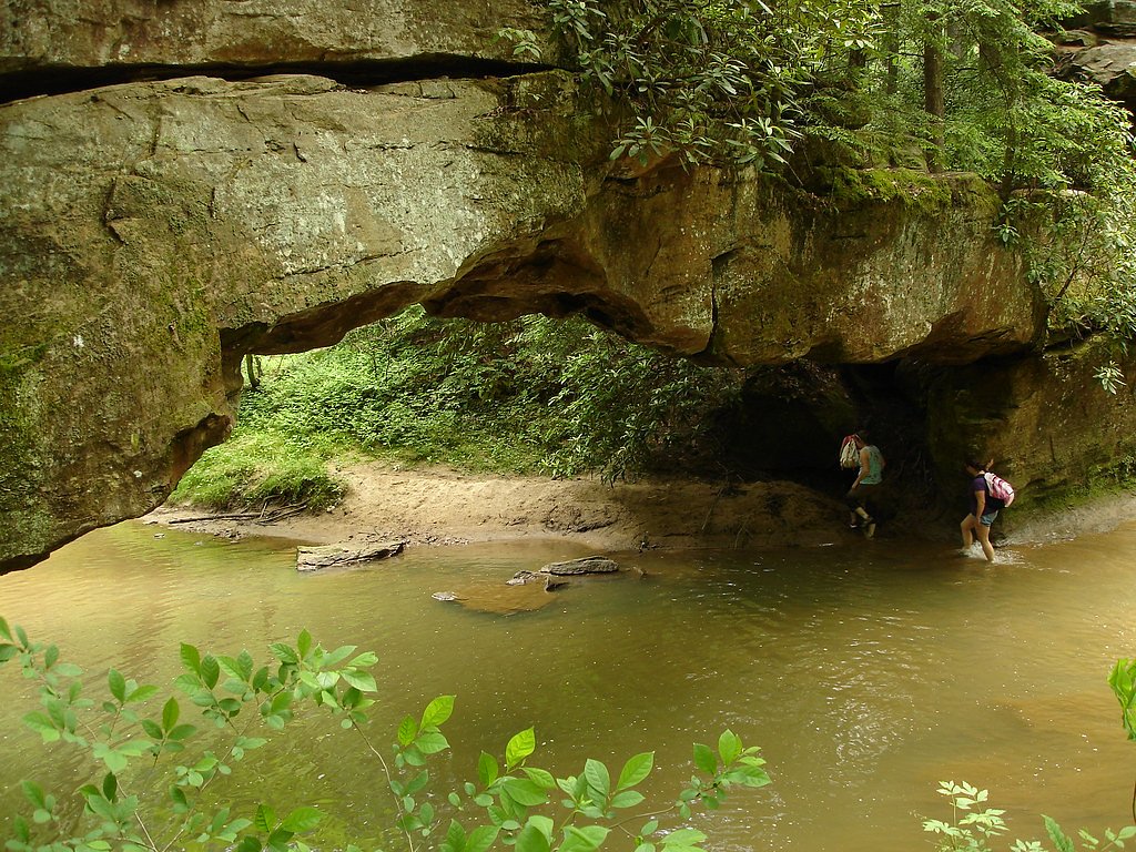
About Rock Bridge Falls
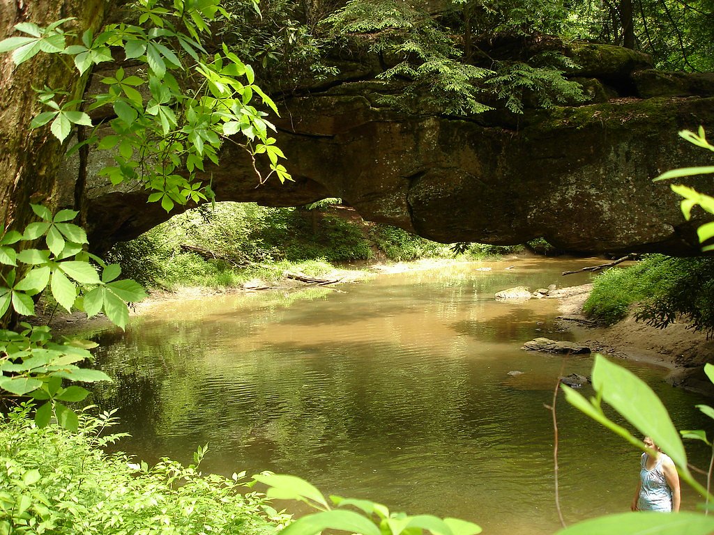
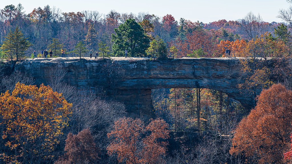
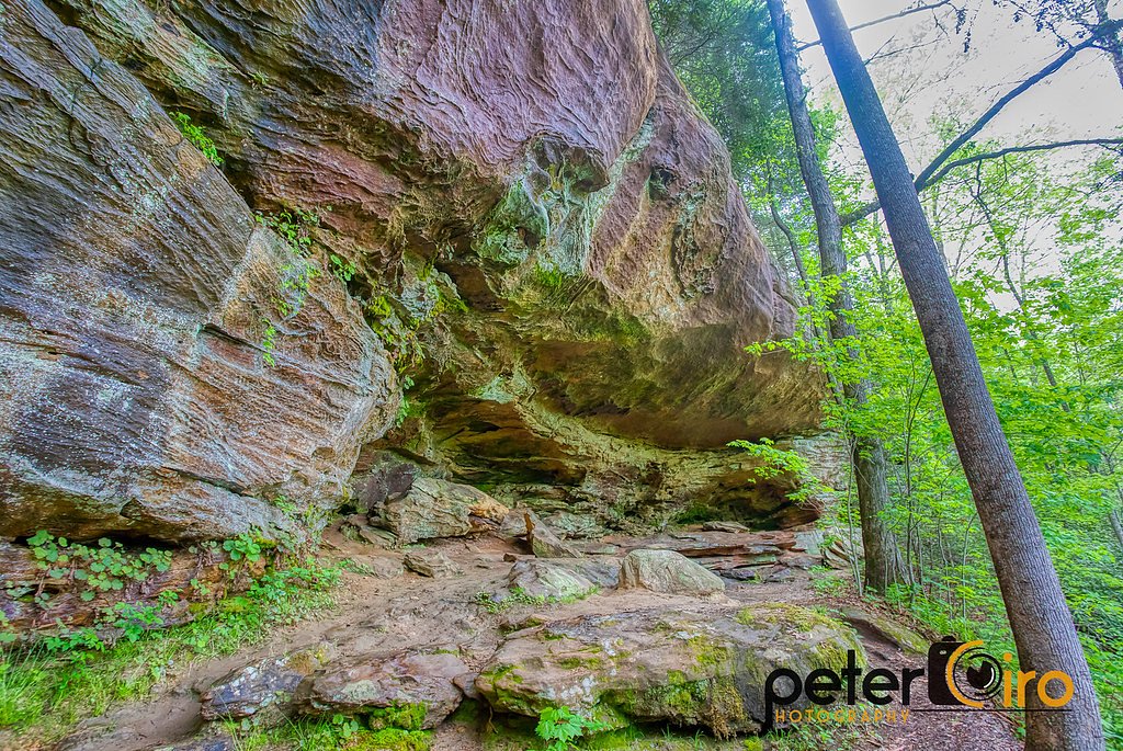
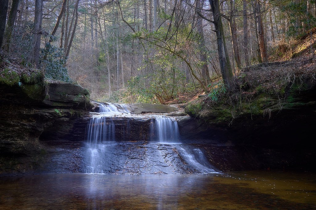
Rock Bridge Falls is a picturesque waterfall located in the Red River Gorge area of Kentucky. It is part of the Rock Bridge Trail, which features a natural sandstone arch and lush forest scenery. The waterfall flows over a rock ledge and is particularly beautiful after rainfall.
The Setting
Rock Bridge Falls sits at 902 feet within Daniel Boone National Forest, fed by the Red River, in the foothills of Kentucky.
Nearby Falls Worth Visiting
Broken Leg Falls (60 ft) lies 10.3 miles to the northeast.
Trail & Hike Details
The Approach
The moderate hike follows Rock Bridge (#207), a 1.5-mile loop trail over n/a. Expect 200 feet of elevation gain with grades of N/A.
USFS Trail
ROCK BRIDGE #207
Trail Class
Class 0
Surface
Avg Grade
USFS Segment
1.29 miTrail Description
The Rock Bridge Trail is a 1.5-mile loop that takes visitors through a lush forest, past a natural sandstone arch, and to Rock Bridge Falls. The trail is well-marked but includes some uneven terrain and moderate elevation changes. The waterfall is located near the end of the loop and is a highlight of the hike.
What to Expect
Dogs are welcome.
Accessibility
The trail is not wheelchair accessible. Uneven terrain and elevation changes require steady footing.
Frequently Asked Questions
🐶 Are Dogs Allowed at Rock Bridge Falls?
✅ Dogs are allowed
Are There Any Fees or Permits Required?
🆖 No fees required
🏊 Is There Swimming at Rock Bridge Falls?
❌ Swimming is not allowed
When to Visit
Spring and fall are the best times to visit due to pleasant weather and vibrant foliage. The waterfall is most active after rainfall.
Seasonal Access
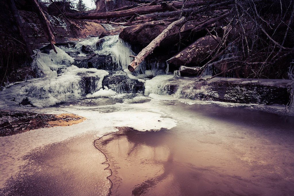
The best time to visit is Spring, Summer, and Fall. Winter access may be limited. Check with Daniel Boone National Forest for seasonal road closures.
Safety Information
The trail can be slippery after rain, so exercise caution. Watch for roots and rocks that may pose tripping hazards. Cell phone service may be limited in the area, so plan accordingly.
Current Water Conditions
14 ft³/s
Current discharge — how much water is flowing
About average for this time of year
Based on 66 years of record
2.83 ft
Water depth at gauge
7-Day Discharge Trend
What does this mean for your visit?
Flow is about average for this time of year.
About This Gauge
This gauge is on a nearby waterway and may not reflect exact conditions at the falls.
7-Day Flow Outlook
Based on the USGS gauge RED RIVER NEAR HAZEL GREEN, KY (10 km away).
Today
Barely Flowing
14 cfs
5/10Tomorrow
Low
15 cfs
3/10Sat
Low
17 cfs
3/10Sun
Low
17 cfs
3/10Mon
Barely Flowing
15 cfs
5/10Tue
Barely Flowing
12 cfs
5/10Wed
Barely Flowing
12 cfs
5/10Best window: Today — barely flowing flow, sunny (trip score 5/10).
Best time of year: this gauge typically runs highest from late January to mid April, peaking in February.
How we calculate this
This is a transparent outlook, not a precise forecast. We take the waterfall's current flow strength (how it ranks against its historical normal for today, from the nearest USGS stream gauge), carry that ranking forward along the gauge's seasonal curve, and nudge it for forecast rain. Confidence is highest for the next day or two and falls further out. Always check official conditions and your own judgment before visiting — high flows can be dangerous.
Know when to go.
Get a free email alert when waterfalls near Campton hit peak flow. We only send when conditions are worth the trip — no weekly newsletters, no spam.
Weather Forecast
Location & Access
Getting There
Rock Bridge Falls is located within the Daniel Boone National Forest in the Red River Gorge area. The trailhead for the Rock Bridge Trail can be accessed via Rock Bridge Road, which is off KY-715. The road to the trailhead is gravel and may be rough in some areas, so drive cautiously.
Get Directions on Google MapsParking
There is a small parking area at the trailhead for the Rock Bridge Trail. Parking is free, but spaces may be limited during peak seasons.
Elevation
902 feet above sea level
Coordinates
37.769460° N, -83.561745° W
Land Management
Managed by USFS
Visitor Tips & Gear
Wear sturdy hiking shoes, as the trail can be uneven and slippery in places. Bring water and snacks, especially during warmer months. Arrive early to secure parking, as the lot can fill up quickly on weekends and holidays.
As an Amazon Associate, we earn from qualifying purchases.
With 1.5 miles and 200 ft of elevation gain, sturdy boots and trekking poles will help on this moderate trail. Sun exposure on the trail makes good sun protection a must in summer.

Polarized Sunglasses (Knockaround)
Cuts glare off the water so you actually see the falls — and your photos turn out better too.

Columbia Watertight II Rain Jacket
Packs into its own pocket, seam-sealed, and keeps you dry from spray and surprise rain.

Earth Pak Waterproof Dry Bag
Keeps your phone and gear dry when waterfall mist soaks everything else.

Waterproof Phone Pouch (AiRunTech)
Cheap insurance — take photos right next to the falls without killing your phone.

Timberland Euro Sprint Mid Waterproof
Trusted waterproof boot with premium leather and grippy rubber sole — reliable on rocky, wet trails.

TrailBuddy Trekking Poles
Lightweight aluminum, cork grips, and flip-locks that actually hold — a best-seller for good reason.
Where to Stay

Romantic Secluded Hot Tub, Stargazing, Mt View

"Cozy Dumplin" - Warm & Modern Stay in RRG/Auxier

Trailseeker Cabin w King Bed Hot Tub at Red River Gorge Natural Bridge

Cliffside Family Retreat with View
Browse vacation cabins and private rentals nearby
Unique outdoor stays — tents, yurts, and treehouses
Rent a campervan or RV for your waterfall road trip
Some links are affiliate links. We may earn a commission at no extra cost to you.
Nearby Campground
KOOMER RIDGE CAMPGROUND
4 miles away · 54 sites
Overview This Campground offers dozens of shaded, wooded campsites. 54 suitable for tents and 19 suitable for a trailer. Camping and fires are prohibited in rock shelters. Recreation The Red River Gorge offers untouched beauty for hiking enthusiasts. From the campground access: Hidden Arch Trail, Koomer Ridge Trail, Cliff Trail and Silvermine Arch Trail. Facilities All sites have a picnic table and fire ring. Accessible vault toilets are available year round. Flush toilets and showers are ava
Book on Recreation.govAdditional Information
Nearby Attractions
Nearby attractions include Sky Bridge, Chimney Top Rock, and the Natural Bridge State Resort Park.
Wildlife
The area is home to a variety of wildlife, including deer, birds, and small mammals. Be cautious of snakes, especially during warmer months.
Cities near Rock Bridge Falls
Nearby Waterfalls
Writing about Rock Bridge Falls? Embed this waterfall on your site for free.