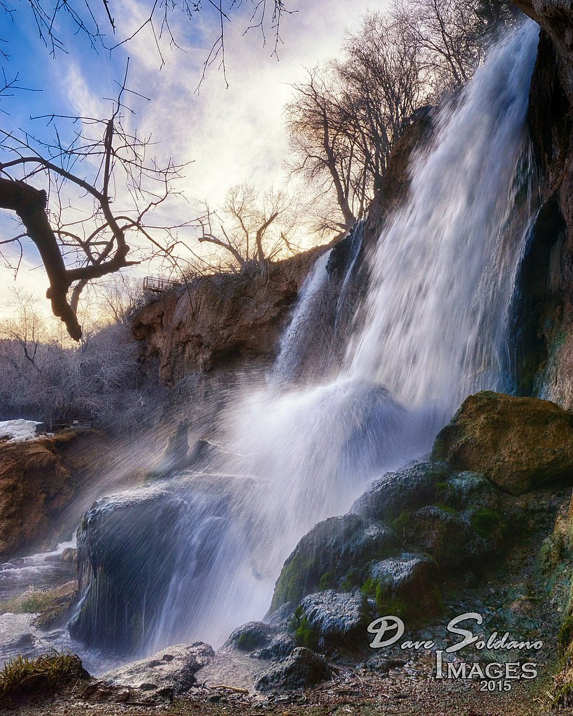
Rifle Falls
Colorado • 70 ft
By Armen Suny · Last verified Mar 2026
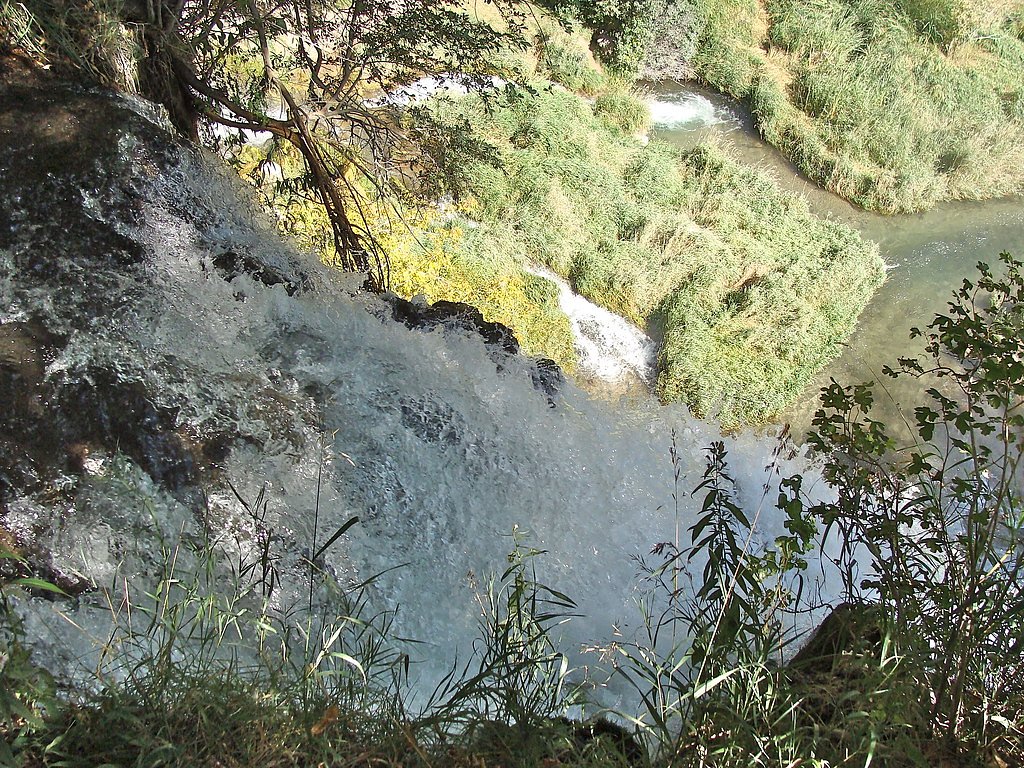
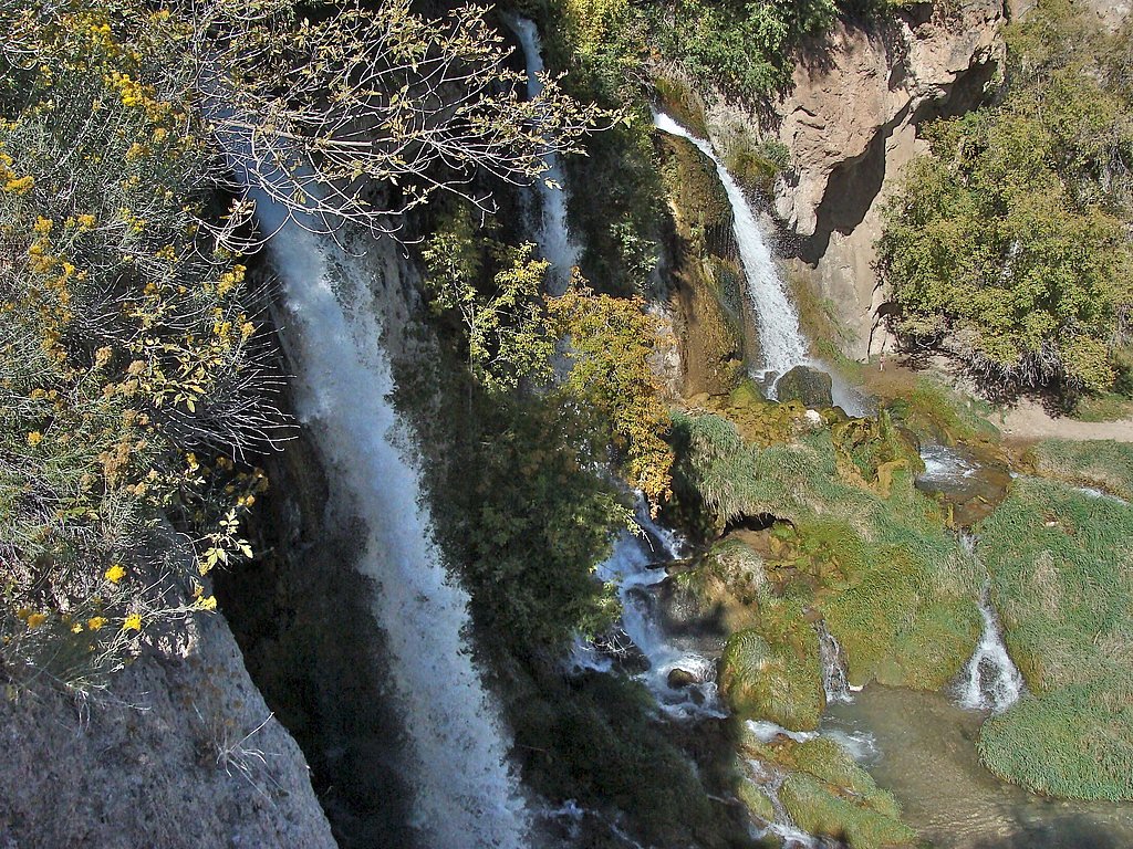
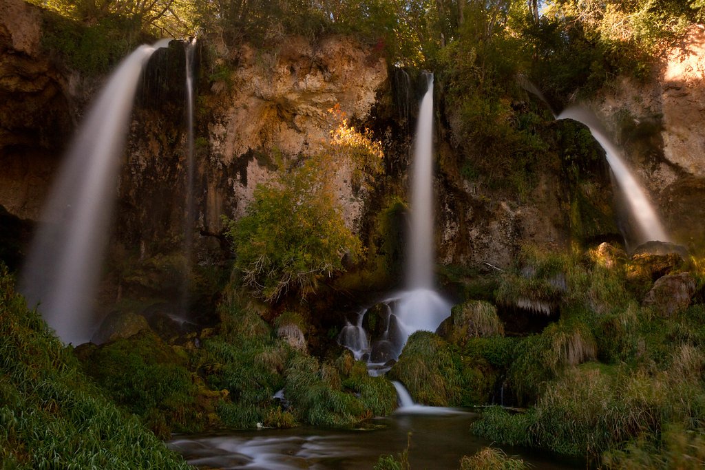
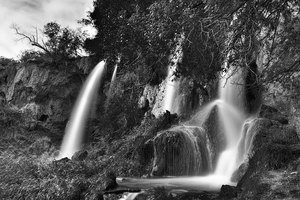

Photo Credits (5)
Difficulty
Easy
Trail Length
1.5 miles
Trail Type
Loop
Elevation Gain
100 ft
About Rifle Falls
Rifle Falls is a stunning triple waterfall located in Rifle Falls State Park, Colorado. Known for its lush surroundings and unique limestone caves, it is a popular destination for nature enthusiasts and photographers.
The Setting
Rifle Falls sits at 6,604 feet within Rifle Falls State Park, fed by the Divide Creek, in the high mountains of Colorado. The falls drop 70 feet.
Height: 70 feet
Trail & Hike Details
The Approach
The easy 1.5-mile loop trail gains 100 feet of elevation on the way to the falls.
Trail Description
The trail to Rifle Falls is a short and easy loop that takes visitors to the base of the falls and through nearby limestone caves. The trail is well-maintained and suitable for most visitors, including families with children.
What to Expect
The falls drop 70 feet. Dogs are welcome.
Accessibility
The trail is not wheelchair accessible. Uneven terrain and elevation changes require steady footing.
Frequently Asked Questions
🐶 Are Dogs Allowed at Rifle Falls?
✅ Dogs are allowed
Are There Any Fees or Permits Required?
🤑 Fee: $9.00
🏊 Is There Swimming at Rifle Falls?
❌ Swimming is not allowed
When to Visit
Spring and early summer are the best times to visit, as the falls are typically at their fullest due to snowmelt. However, the park is beautiful year-round, with fall offering vibrant foliage and winter showcasing frozen waterfalls.
Seasonal Access
The best time to visit is Spring, Summer, Fall, and Winter.
Safety Information
The rocks near the falls can be slippery, so exercise caution when walking close to the water. Be mindful of uneven terrain in the caves.
Current Water Conditions
1 ft³/s
Current discharge — how much water is flowing
About average for this time of year
Based on 3 years of record
4.92 ft
Water depth at gauge
7-Day Discharge Trend
What does this mean for your visit?
Flow is about average for this time of year.
About This Gauge
This gauge is on a nearby waterway and may not reflect exact conditions at the falls.
7-Day Flow Outlook
Based on the USGS gauge DIVIDE CREEK NEAR SILT, CO (17 km away).
Today
Moderate
1 cfs
9/10Tomorrow
Moderate
1 cfs
9/10Wed
Moderate
1 cfs
9/10Thu
Moderate
1 cfs
9/10Fri
Moderate
1 cfs
9/10Sat
Moderate
1 cfs
9/10Sun
Moderate
1 cfs
9/10Best window: Today — moderate flow, sunny then smoke (trip score 9/10).
Best time of year: this gauge typically runs highest from early March to late April, peaking in May.
How we calculate this
This is a transparent outlook, not a precise forecast. We take the waterfall's current flow strength (how it ranks against its historical normal for today, from the nearest USGS stream gauge), carry that ranking forward along the gauge's seasonal curve, and nudge it for forecast rain. Confidence is highest for the next day or two and falls further out. Always check official conditions and your own judgment before visiting — high flows can be dangerous.
Know when to go.
Get a free email alert when waterfalls near Silt hit peak flow. We only send when conditions are worth the trip — no weekly newsletters, no spam.
Weather Forecast
Location & Access
Getting There
Rifle Falls is located approximately 14 miles north of the town of Rifle, Colorado. From Rifle, take Highway 13 north, then turn east onto Highway 325 and follow signs to Rifle Falls State Park.
Get Directions on Google MapsParking
Parking is available at Rifle Falls State Park, but it can fill up quickly during peak seasons. Overflow parking may be available nearby.
Elevation
6,604 feet above sea level
Coordinates
39.677754° N, -107.698661° W
Land Management
Managed by SPR
Visitor Tips & Gear
Arrive early to secure parking, especially during weekends and holidays. Wear sturdy shoes if you plan to explore the caves, as the ground can be uneven and slippery. Bring a camera to capture the scenic beauty of the falls.
This trail sits at 6,604 ft above sea level
Elevated TrailUV radiation is roughly 26% stronger at this elevation than at sea level, and the dry air accelerates dehydration. Extra sun protection and fluids go a long way.
As an Amazon Associate, we earn from qualifying purchases.

Coppertone Sport SPF 50 Sunscreen
UV intensity jumps ~4% per 1,000 ft — at this elevation you can burn in half the time.

Sun Bum SPF 30 Lip Balm (3-Pack)
Lips have almost no natural UV protection and burn fast in thin, dry mountain air.

Liquid I.V. Electrolyte Packets
You lose moisture ~2x faster at elevation — electrolytes help you absorb water efficiently.

ROCKNIGHT Polarized UV400 Sunglasses
High-altitude glare off rock and water is intense — UV400 lenses block 99%+ of UVA/UVB.
As an Amazon Associate, we earn from qualifying purchases.
This easy 1.5 miles hike is straightforward — comfortable trail shoes and plenty of water should do. Icy conditions are common in winter — traction cleats are a smart addition.

Columbia Watertight II Rain Jacket
Packs into its own pocket, seam-sealed, and keeps you dry from spray and surprise rain.

Polarized Sunglasses (Knockaround)
Cuts glare off the water so you actually see the falls — and your photos turn out better too.

Earth Pak Waterproof Dry Bag
Keeps your phone and gear dry when waterfall mist soaks everything else.

Waterproof Phone Pouch (AiRunTech)
Cheap insurance — take photos right next to the falls without killing your phone.

Kahtoola MICROspikes
Cult-favorite traction cleats that grip ice and wet rock — essential for winter waterfall hikes.

JOBY GorillaPod Starter Kit
Wraps around railings and rocks for long-exposure waterfall shots — no flat surface needed.
Where to Stay

Holiday Inn Express Hotel & Suites Silt - Rifle by IHG

Glenwood Hot Springs Resort

La Quinta by Wyndham Rifle

Million Dollar Luxury Villa Ski Fish Hike Raft Mins to downtown
Browse vacation cabins and private rentals nearby
Unique outdoor stays — tents, yurts, and treehouses
Rent a campervan or RV for your waterfall road trip
Some links are affiliate links. We may earn a commission at no extra cost to you.
Nearby Campground
SW/Central Flat Tops Area
11.7 miles away · 0 sites
Southwest and central Flat Tops area. Access often from New Castle.
Book on Recreation.govNearby Hot Springs
Hot springs near Silt, Colorado
South Canyon Hot Springs
South Canyon Hot Springs delivers 118 degrees Fahrenheit at just 7.3 meters from Canyon Creek Road, making this one of Colorado...
Iron Mountain Hot Springs
Iron Mountain Hot Springs occupies the banks of the Colorado River in Glenwood Springs at 5,740 feet elevation, where a develop...
Yampah Hot Springs Vapor Caves
Yampah Hot Springs Vapor Caves occupy a unique niche in Colorado geothermal culture as the source of natural steam caves in the...

Glenwood Springs
Glenwood Springs reaches 124 degrees Fahrenheit and channels through the Sacred Waters facility in downtown Glenwood, standing ...
Dotsero Warm Springs
Dotsero Warm Springs flows at 90 degrees Fahrenheit along Eagle River corridor public lands, carrying extraordinary dissolved s...
Avalanche Ranch Hot Springs
Avalanche Ranch Hot Springs flows at 48 degrees Fahrenheit near Carbondale, making it the coolest thermal feature in this datas...
Looking for a soak after your hike? Explore more hot springs near Silt, Colorado on SoakingSprings.
Explore Colorado springsAdditional Information
Nearby Attractions
Rifle Gap State Park and Rifle Mountain Park are nearby and offer additional recreational opportunities such as hiking, fishing, and camping.
Wildlife
Visitors may encounter deer, birds, and small mammals in the area. Be cautious and respectful of wildlife.
Cities near Rifle Falls
Writing about Rifle Falls? Embed this waterfall on your site for free.