
Photo Credits (5)
Difficulty
Moderate
Trail Length
3.5 miles
Trail Type
Out And Back
Elevation Gain
500 ft
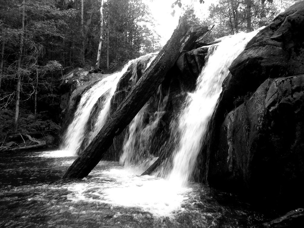
About Red Rock Falls
Red Rock Falls sits amid striking red sandstone outcrops on public BLM land managed by the Needles Field Office, offering a compact but rewarding taste of Southern California’s desert-tinged scenery. The cascade threads through vivid red rock formations that are especially photogenic after rainfall, when the falls swell and the contrast between water and stone is most dramatic. The site’s BLM designation means the area is maintained for recreation and natural resource protection, so you’ll find a relatively undeveloped, natural setting rather than formal park infrastructure. The hike to the falls is a pleasant option for day hikers and nature lovers looking for a moderate outing. The route is an out-and-back roughly 3.5 miles round trip with about 500 feet of elevation gain, so it’s achievable in a half to full day depending on stops. Expect a mix of shaded stretches and open terrain with some rocky sections underfoot; sturdy shoes and plenty of water are recommended. Because the area is managed by the BLM Needles Field Office and lies on public land (designation: PUB), visitors should practice Leave No Trace to help keep the falls and surrounding red-rock landscape pristine.
The Setting
Red Rock Falls sits at 702 feet within Needles Field Office, in the foothills of California.
Trail & Hike Details
The Approach
The moderate 3.5-mile out-and-back trail gains 500 feet of elevation on the way to the falls.
Trail Description
Out-and-back route, approximately 3.5 miles round trip with ~500 feet of elevation gain and rated moderate. The trail follows a natural, undeveloped tread that alternates between open sun-exposed sections and shaded washes; there are several rocky stretches and uneven footing rather than paved or heavily improved surfaces. Grade changes are moderate overall, with short uphill pitches and downhill returns; no technical climbing or maintained switchbacks are required, but hikers should be prepared for loose rock in places. Managed by the BLM Needles Field Office on public (PUB) land, the route is best navigated with good trail shoes, water, and basic navigation awareness.
What to Expect
Swimming is permitted. Dogs are welcome.
Accessibility
The trail is not wheelchair accessible. Uneven terrain and elevation changes require steady footing.
Frequently Asked Questions
🐶 Are Dogs Allowed at Red Rock Falls?
✅ Dogs are allowed
Are There Any Fees or Permits Required?
🆖 No fees required
🏊 Is There Swimming at Red Rock Falls?
✅ Swimming is allowed
When to Visit
The best time to visit is in the spring or early summer when the waterfall is likely to have the most water flow. Fall can also be a pleasant time to visit due to cooler temperatures.
Seasonal Access
The best time to visit is Spring, Summer, and Fall. Winter access may be limited.
Safety Information
Be cautious of slippery rocks near the waterfall and avoid climbing on unstable surfaces. Check weather conditions before visiting, as the trail may be hazardous after heavy rain.
Know when to go.
Get a free email alert when waterfalls near Golden Shores hit peak flow. We only send when conditions are worth the trip — no weekly newsletters, no spam.
Weather Forecast
Location & Access
Getting There
Red Rock Falls is located in the Los Padres National Forest, near the Santa Barbara area. Access typically involves driving to a trailhead and hiking to the falls.
Get Directions on Google MapsParking
Parking is available at the trailhead, but spaces may be limited during peak seasons. Visitors are advised to arrive early to secure a spot.
Elevation
702 feet above sea level
Coordinates
34.659726° N, -114.477023° W
Land Management
Managed by BLM
Visitor Tips & Gear
Wear sturdy hiking shoes as the trail can be rocky in sections. Bring plenty of water, especially during warmer months, and consider visiting early in the day to avoid crowds and secure parking.
As an Amazon Associate, we earn from qualifying purchases.
With 3.5 miles and 500 ft of elevation gain, sturdy boots and trekking poles will help on this moderate trail. Sun exposure on the trail makes good sun protection a must in summer.

Polarized Sunglasses (Knockaround)
Cuts glare off the water so you actually see the falls — and your photos turn out better too.

Columbia Watertight II Rain Jacket
Packs into its own pocket, seam-sealed, and keeps you dry from spray and surprise rain.

Earth Pak Waterproof Dry Bag
Keeps your phone and gear dry when waterfall mist soaks everything else.

Waterproof Phone Pouch (AiRunTech)
Cheap insurance — take photos right next to the falls without killing your phone.

Timberland Euro Sprint Mid Waterproof
Trusted waterproof boot with premium leather and grippy rubber sole — reliable on rocky, wet trails.

TrailBuddy Trekking Poles
Lightweight aluminum, cork grips, and flip-locks that actually hold — a best-seller for good reason.
Where to Stay

Topock66 Hotel

Days Inn & Suites by Wyndham Needles

Rio Del Sol Inn Needles

Travelodge by Wyndham Lake Havasu
Browse vacation cabins and private rentals nearby
Unique outdoor stays — tents, yurts, and treehouses
Rent a campervan or RV for your waterfall road trip
Some links are affiliate links. We may earn a commission at no extra cost to you.
Nearby Hot Springs
Hot springs near Golden Shores, California

Oatman Warm Springs
Oatman Warm Springs flows at 91°F in the low Colorado River desert near Mohave Valley, running 20 degrees above the 71°F averag...
Caliche Spring
Caliche Spring in Mohave County flows at 79 degrees Fahrenheit at 2,188 feet elevation near Golden Valley, emerging 8.1 degrees...
Tom Brown Warm Spring
Tom Brown Warm Spring flows at 82°F near Kingman, running 14 degrees above the region's 68°F average, with moderate mineral con...

Unnamed Spring Mohave County
This unnamed 73-degree spring flows on Bureau of Land Management lands in Mohave County near Kingman, reaching 13.4 degrees abo...
Frost Mine Spring
Frost Mine Spring flows at 70 degrees Fahrenheit on BLM public lands in Mohave County near Kingman at 4,270 feet elevation, eme...
Looking for a soak after your hike? Explore more hot springs near Golden Shores, California on SoakingSprings.
Explore California springsAdditional Information
Nearby Attractions
Nearby attractions include the Santa Ynez River and other hiking trails in the Los Padres National Forest.
Wildlife
The area is home to a variety of wildlife, including birds, deer, and occasionally snakes. Visitors should stay on the trail and be mindful of their surroundings.
Cities near Red Rock Falls
Other waterfalls named Red Rock Falls
1 other waterfall shares this name across the U.S.
Writing about Red Rock Falls? Embed this waterfall on your site for free.