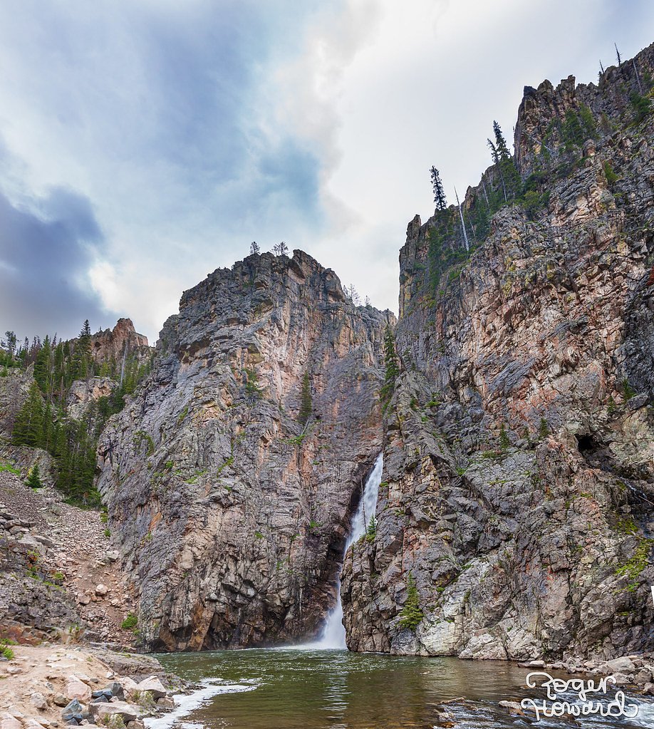
Porcupine Falls
Wyoming • 70 ft
By Armen Suny · Last verified May 2026
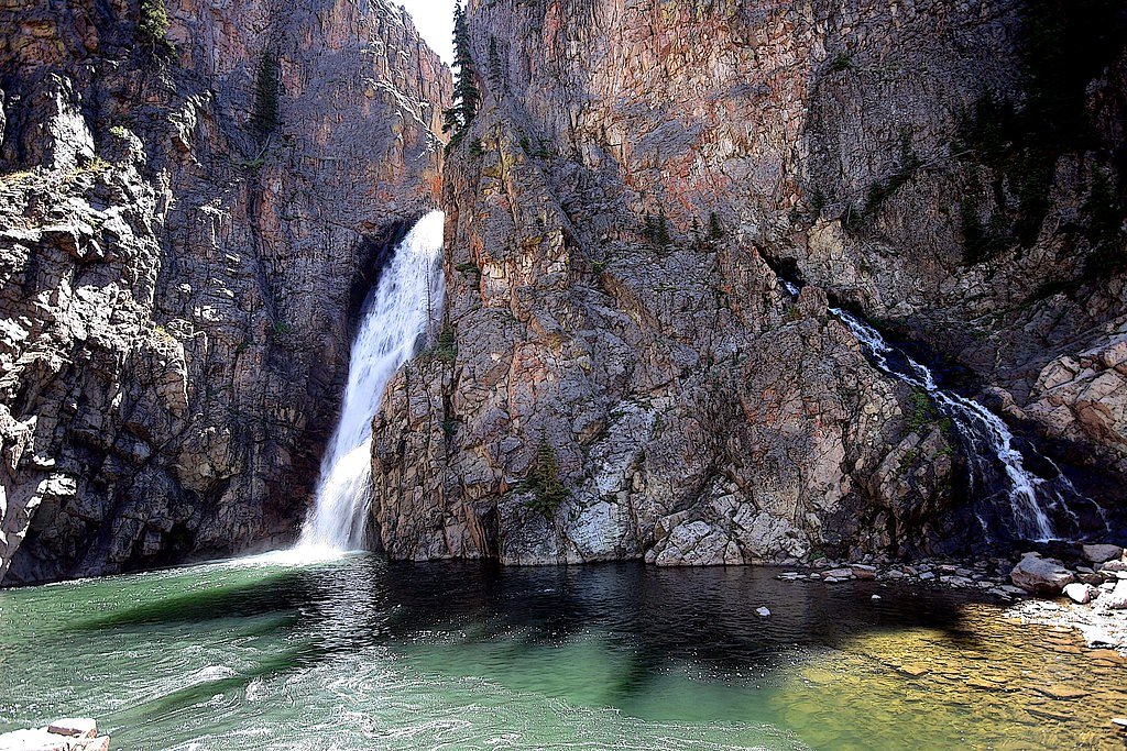
Photo Credits (3)
Difficulty
Moderate
Trail Length
0.8 miles
Trail Type
Out And Back
Elevation Gain
400 ft
About Porcupine Falls
Porcupine Falls is a picturesque waterfall located in the Bighorn National Forest in Wyoming. It cascades into a serene pool surrounded by rugged cliffs and lush greenery, making it a popular destination for hikers and nature enthusiasts.
The Setting
Porcupine Falls sits at 8,022 feet within Bighorn National Forest, fed by the Bighorn River, in the high alpine of Wyoming. The falls drop 70 feet.
Height: 70 feet
Nearby Falls Worth Visiting
Bucking Mule Falls, the tallest waterfall in Wyoming at 600 feet, lies 2.9 miles to the north.
Trail & Hike Details
The Approach
The moderate hike follows Porcupine Falls (#135), a 0.8-mile out-and-back trail over natural surface. Expect 400 feet of elevation gain with grades of 5-8%. The trail is developed (Class 3).
USFS Trail
PORCUPINE FALLS #135
Trail Class
Developed
Surface
Avg Grade
USFS Segment
0.23 miTrail Description
The trail to Porcupine Falls is short but steep, descending approximately 400 feet to the base of the waterfall. The path is rocky and can be slippery, especially after rain. Hikers should wear sturdy footwear and be prepared for a challenging climb back up to the trailhead.
What to Expect
The falls drop 70 feet. Swimming is permitted. Dogs are welcome.
Accessibility
The trail is not wheelchair accessible. Uneven terrain and elevation changes require steady footing.
Frequently Asked Questions
🐶 Are Dogs Allowed at Porcupine Falls?
✅ Dogs are allowed
Are There Any Fees or Permits Required?
🆖 No fees required
🏊 Is There Swimming at Porcupine Falls?
✅ Swimming is allowed
When to Visit
The best time to visit Porcupine Falls is during late spring through early fall when the trail is free of snow and the waterfall is flowing strongly.
Seasonal Access
The best time to visit is Spring, Summer, and Fall. Access roads and trails may close during winter due to snow. Check with Bighorn National Forest for seasonal road closures.
Safety Information
The trail can be steep and slippery, so proper footwear is essential. Be cautious near the edge of the waterfall and supervise children closely. Carry bear spray and be aware of wildlife in the area.
Current Water Conditions
1,310 ft³/s
Current discharge — how much water is flowing
Lower than usual for this time of year
Based on 96 years of record
2.36 ft
Water depth at gauge
7-Day Discharge Trend
What does this mean for your visit?
Flow is lower than usual for this time of year.
About This Gauge
This gauge is on a nearby waterway and may not reflect exact conditions at the falls.
7-Day Flow Outlook
Based on the USGS gauge BIGHORN RIVER AT KANE, WY (24 km away).
Today
Roaring
1493 cfs
6/10Tomorrow
Roaring
1471 cfs
6/10Fri
Roaring
1465 cfs
6/10Sat
Roaring
1386 cfs
6/10Sun
Roaring
1269 cfs
6/10Mon
Roaring
1178 cfs
6/10Tue
Roaring
1072 cfs
9/10Best window: Tue — roaring flow, sunny (trip score 9/10).
Best time of year: this gauge typically runs highest from early May to mid July, peaking in June.
How we calculate this
This is a transparent outlook, not a precise forecast. We take the waterfall's current flow strength (how it ranks against its historical normal for today, from the nearest USGS stream gauge), carry that ranking forward along the gauge's seasonal curve, and nudge it for forecast rain. Confidence is highest for the next day or two and falls further out. Always check official conditions and your own judgment before visiting — high flows can be dangerous.
Know when to go.
Get a free email alert when waterfalls near Lovell hit peak flow. We only send when conditions are worth the trip — no weekly newsletters, no spam.
Weather Forecast
Location & Access
Getting There
Porcupine Falls is accessed via Forest Road 14A in the Bighorn National Forest. The trailhead is well-marked and located approximately 13 miles west of Burgess Junction.
Get Directions on Google MapsParking
There is a small parking area near the trailhead, but it may fill up quickly during peak seasons.
Elevation
8,022 feet above sea level
Coordinates
44.855417° N, -107.915358° W
Land Management
Managed by USFS
Visitor Tips & Gear
Start your hike early in the day to avoid crowds and bring plenty of water, as the climb back to the trailhead can be strenuous. Be cautious on the trail, especially if it has rained recently, as the rocks can be slippery.
This trail sits at 8,022 ft — the air is noticeably thinner
High AltitudeSome visitors experience headaches, fatigue, or shortness of breath at this elevation. Take it slow, stay hydrated, and consider supplemental oxygen if you're coming from a lower altitude.
As an Amazon Associate, we earn from qualifying purchases.

Coppertone Sport SPF 50 Sunscreen
UV intensity jumps ~4% per 1,000 ft — at this elevation you can burn in half the time.

Sun Bum SPF 30 Lip Balm (3-Pack)
Lips have almost no natural UV protection and burn fast in thin, dry mountain air.

Liquid I.V. Electrolyte Packets
You lose moisture ~2x faster at elevation — electrolytes help you absorb water efficiently.

ROCKNIGHT Polarized UV400 Sunglasses
High-altitude glare off rock and water is intense — UV400 lenses block 99%+ of UVA/UVB.

Boost Oxygen 10L Canister (2-Pack)
Portable supplemental oxygen for quick relief from headaches and shortness of breath.

Altitude Rx OxyBoost Complex
Antioxidant formula designed to support your body's natural altitude acclimation.
As an Amazon Associate, we earn from qualifying purchases.
With 0.8 miles and 400 ft of elevation gain, sturdy boots and trekking poles will help on this moderate trail. Sun exposure on the trail makes good sun protection a must in summer.

Polarized Sunglasses (Knockaround)
Cuts glare off the water so you actually see the falls — and your photos turn out better too.

Columbia Watertight II Rain Jacket
Packs into its own pocket, seam-sealed, and keeps you dry from spray and surprise rain.

Earth Pak Waterproof Dry Bag
Keeps your phone and gear dry when waterfall mist soaks everything else.

Waterproof Phone Pouch (AiRunTech)
Cheap insurance — take photos right next to the falls without killing your phone.

Timberland Euro Sprint Mid Waterproof
Trusted waterproof boot with premium leather and grippy rubber sole — reliable on rocky, wet trails.

TrailBuddy Trekking Poles
Lightweight aluminum, cork grips, and flip-locks that actually hold — a best-seller for good reason.
Where to Stay

7 Mi to Bighorn Nat’l Forest: Dog-Friendly Home

Cozy Cabin Perfect for a Romantic Escape with BBQ in Dayton, Wyoming
Browse vacation cabins and private rentals nearby
Unique outdoor stays — tents, yurts, and treehouses
Rent a campervan or RV for your waterfall road trip
Some links are affiliate links. We may earn a commission at no extra cost to you.
Nearby Campground
PORCUPINE CAMPGROUND (WY)
3.3 miles away · 16 sites
Overview Porcupine Campground is located along the Medicine Wheel Passage Scenic Byway (U.S. Highway 14A), 33 miles east of Lovell, Wyoming. The Medicine Wheel National Historic Landmark is nearby. Visitors enjoy the area for its scenic natural beauty, recreational opportunities and excellent habitat for a variety of wildlife species. Fishing is popular on nearby streams and lakes. The administering organization is Gallatin Canyon Campgrounds; e-mail: gccampgrounds13@gmail.comRecreation From the
Book on Recreation.govNearby Hot Springs
Hot springs near Lovell, Wyoming

Little Sheep Mountain Spring
Little Sheep Mountain Spring flows at 68 degrees Fahrenheit at 3,712 feet elevation on Bureau of Land Management land, emerging...
Sheep Mountain Springs
Sheep Mountain Springs flows at 70 degrees Fahrenheit in Big Horn County at 4,101 feet elevation, accessible via a 386-meter wa...
Looking for a soak after your hike? Explore more hot springs near Lovell, Wyoming on SoakingSprings.
Explore Wyoming springsAdditional Information
Nearby Attractions
Shell Falls, Medicine Wheel National Historic Landmark, and Cloud Peak Wilderness are nearby attractions worth exploring.
Wildlife
The area is home to a variety of wildlife, including deer, moose, and birds. Visitors should be cautious of bears and carry bear spray.
Cities near Porcupine Falls
Nearby Waterfalls
Writing about Porcupine Falls? Embed this waterfall on your site for free.