Paulina Creek Falls
Oregon • 80 ft
By Armen Suny · Last verified Mar 2026
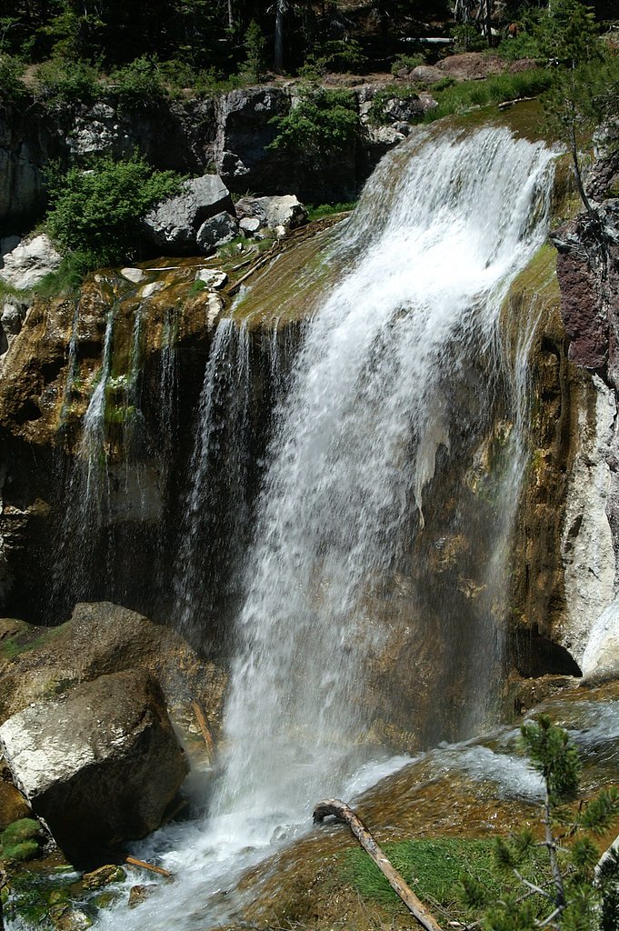
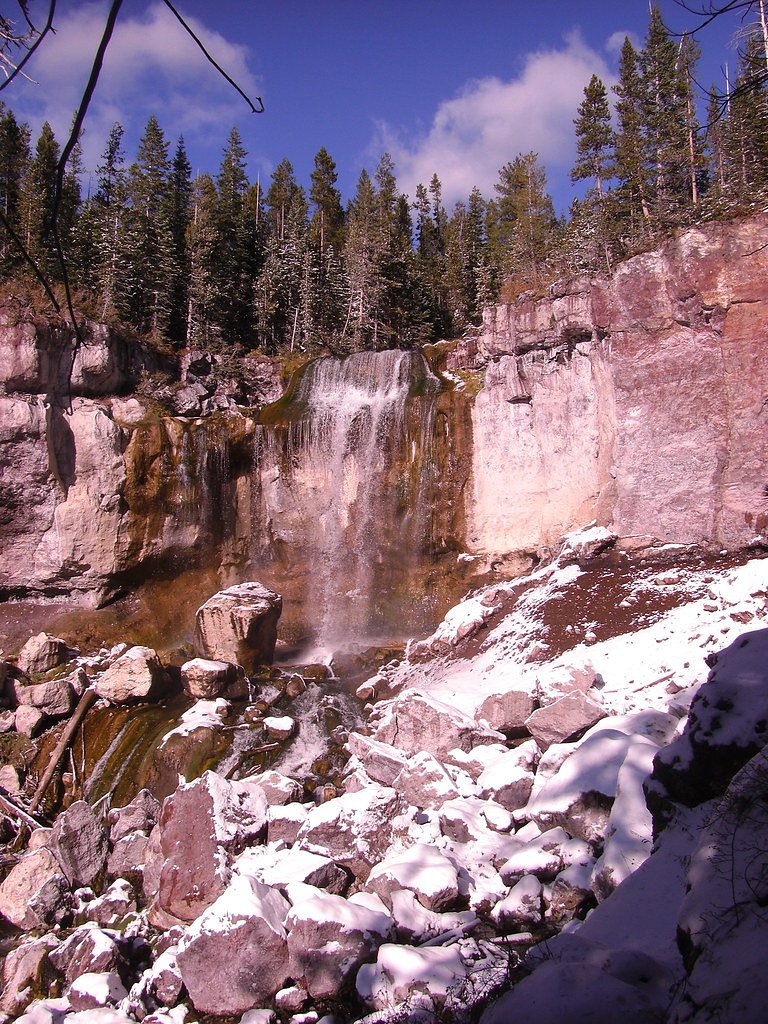
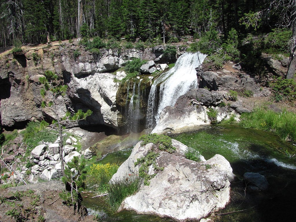
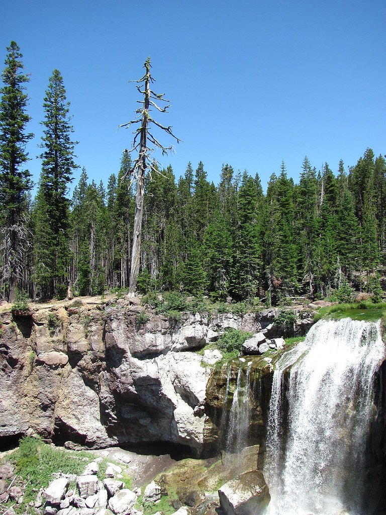

Photo Credits (5)
Difficulty
Moderate
Trail Length
2.4 miles
Trail Type
Out And Back
Elevation Gain
350 ft
About Paulina Creek Falls
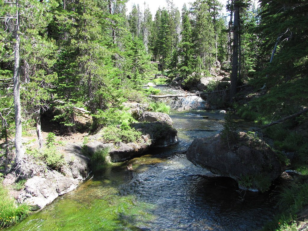
Paulina Creek Falls is a striking cascade-and-plunge waterfall on a stream draining from Paulina Lake, tucked inside the Newberry National Volcanic Monument south of Bend, Oregon. The falls are notable for their side-by-side 80‑foot (24 m) drops that flow around a small island at the lip of a basalt cliff, creating dramatic photo opportunities and a thunderous canyon below. The site sits on lands managed by the U.S. Forest Service within Deschutes National Forest and is a favorite stop for hikers, photographers, and anyone exploring the volcanic landscapes of central Oregon. Access to the falls is commonly made via the USFS PAULINA LAKESHORE LOOP (Trail #3955). Camping is close by—the Newberry Group Camp Site is only about 2.16 km away—making this a pleasant half‑day or overnight outing for visitors who want to explore the lakeshore and nearby trails. The setting is both accessible and wild-feeling, offering a rewarding short trek with big scenery.
The Setting
Paulina Creek Falls sits at 6,266 feet within Deschutes National Forest, fed by the Bridge Creek, in the high mountains of Oregon. The falls drop 80 feet.
Height: 80 feet
Trail & Hike Details
The Approach
The moderate hike follows Paulina Lakeshore Loop (#3955), a 2.4-mile out-and-back trail over natural surface. Expect 350 feet of elevation gain. The trail is developed (Class 3).
USFS Trail
PAULINA LAKESHORE LOOP #3955
Trail Class
Developed
Surface
USFS Segment
2.82 miTrail Description
USFS PAULINA LAKESHORE LOOP (Trail #3955) is recorded in Forest Service GIS as about 2.82 miles of trail and is listed as Trail Class 3 with a native-material surface. Many route descriptions treat the walk to the Paulina Creek Falls viewpoint as a roughly 2.4‑mile out‑and‑back hike with about 350 ft of elevation gain and a moderate difficulty rating. Expect an unpaved, natural-surface trail with some uneven footing—suitable for hikers comfortable on native-material tread and short, moderate climbs.
What to Expect
The falls cascade 80 feet. Dogs are welcome.
Accessibility
The trail is not wheelchair accessible. Uneven terrain and elevation changes require steady footing.
Frequently Asked Questions
🐶 Are Dogs Allowed at Paulina Creek Falls?
✅ Dogs are allowed
Are There Any Fees or Permits Required?
🤑 Fee: $5.00
🏊 Is There Swimming at Paulina Creek Falls?
❌ Swimming is not allowed
When to Visit
The best time to visit is late spring through early fall when the trail is clear of snow and the falls are flowing strongly. Winter visits are possible but may require additional preparation.
Seasonal Access
The best time to visit is Spring, Summer, and Fall. Access roads and trails may close during winter due to snow. Check with Deschutes National Forest for seasonal road closures.
Safety Information
Water temperature is currently 43°F — cold enough to cause numbness quickly. Avoid prolonged water contact and use caution near the falls.
Stay on designated trails and viewing platforms, as the rocks near the falls can be slippery and dangerous. Be cautious of changing weather conditions, especially in winter.
Current Water Conditions
Based on a USGS gauge 26.2 miles away
19 ft³/s
Current discharge — how much water is flowing
About average for this time of year
Based on 8 years of record
0.25 ft
Water depth at gauge
43°F
Very coldExpect numbness within minutes
7-Day Discharge Trend
What does this mean for your visit?
Flow is about average for this time of year. Water temperature is very cold at 43 degrees F, expect numbness within minutes.
About This Gauge
This gauge is on a regional waterway. Conditions at the falls may differ, especially after local rain.
7-Day Flow Outlook
Based on the USGS gauge BRIDGE CREEK BELOW INTAKE, NEAR BEND, OR (42 km away).
Today
Roaring
22 cfs
6/10Tomorrow
Roaring
21 cfs
6/10Sun
Roaring
18 cfs
8/10Mon
Roaring
17 cfs
9/10Tue
Roaring
16 cfs
9/10Wed
Roaring
16 cfs
9/10Thu
Roaring
15 cfs
9/10Best window: Mon — roaring flow, mostly sunny (trip score 9/10).
Best time of year: this gauge typically runs highest from early April to mid June, peaking in May.
How we calculate this
This is a transparent outlook, not a precise forecast. We take the waterfall's current flow strength (how it ranks against its historical normal for today, from the nearest USGS stream gauge), carry that ranking forward along the gauge's seasonal curve, and nudge it for forecast rain. Confidence is highest for the next day or two and falls further out. Always check official conditions and your own judgment before visiting — high flows can be dangerous.
Know when to go.
Get a free email alert when waterfalls near La Pine hit peak flow. We only send when conditions are worth the trip — no weekly newsletters, no spam.
Weather Forecast
Location & Access
Getting There
Paulina Creek Falls is located within the Newberry National Volcanic Monument, approximately 25 miles south of Bend, Oregon. From Bend, take Highway 97 south to Paulina Lake Road (Forest Road 21) and follow the signs to the falls. The falls are accessible via a short walk from the parking area.
Get Directions on Google MapsParking
There is a designated parking area near the falls, which is typically sufficient for visitors. However, it may fill up during peak summer weekends.
Elevation
6,266 feet above sea level
Coordinates
43.712314° N, -121.282345° W
Land Management
Managed by USFS
Visitor Tips & Gear
Arrive early during summer weekends to secure parking. Bring sturdy shoes, as the area around the falls can be rocky. If visiting in winter, check road conditions and consider bringing snowshoes or traction devices.
This trail sits at 6,266 ft above sea level
Elevated TrailUV radiation is roughly 25% stronger at this elevation than at sea level, and the dry air accelerates dehydration. Extra sun protection and fluids go a long way.
As an Amazon Associate, we earn from qualifying purchases.

Coppertone Sport SPF 50 Sunscreen
UV intensity jumps ~4% per 1,000 ft — at this elevation you can burn in half the time.

Sun Bum SPF 30 Lip Balm (3-Pack)
Lips have almost no natural UV protection and burn fast in thin, dry mountain air.

Liquid I.V. Electrolyte Packets
You lose moisture ~2x faster at elevation — electrolytes help you absorb water efficiently.

ROCKNIGHT Polarized UV400 Sunglasses
High-altitude glare off rock and water is intense — UV400 lenses block 99%+ of UVA/UVB.
As an Amazon Associate, we earn from qualifying purchases.
With 2.4 miles and 350 ft of elevation gain, sturdy boots and trekking poles will help on this moderate trail. Sun exposure on the trail makes good sun protection a must in summer.

Polarized Sunglasses (Knockaround)
Cuts glare off the water so you actually see the falls — and your photos turn out better too.

Columbia Watertight II Rain Jacket
Packs into its own pocket, seam-sealed, and keeps you dry from spray and surprise rain.

Earth Pak Waterproof Dry Bag
Keeps your phone and gear dry when waterfall mist soaks everything else.

Waterproof Phone Pouch (AiRunTech)
Cheap insurance — take photos right next to the falls without killing your phone.

Timberland Euro Sprint Mid Waterproof
Trusted waterproof boot with premium leather and grippy rubber sole — reliable on rocky, wet trails.

TrailBuddy Trekking Poles
Lightweight aluminum, cork grips, and flip-locks that actually hold — a best-seller for good reason.
Where to Stay

Loft home with private hot tub deck grill fireplace & 10 SHARC passes

Cabin with Private Hot Tub Near the Deschutes River - Free SHARC access

Paper Birch - Unit 10

2 Tennis Village..
Browse vacation cabins and private rentals nearby
Unique outdoor stays — tents, yurts, and treehouses
Rent a campervan or RV for your waterfall road trip
Some links are affiliate links. We may earn a commission at no extra cost to you.
Nearby Campground
NEWBERRY GROUP CAMP SITE
1.3 miles away · 3 sites
Overview Boasting some of central Oregon's most spectacular scenery, Newberry Group Campground is the only exclusive group site area within the Newberry National Volcanic Monument.Located along the south shore of Paulina Lake in Deschutes National Forest, this site offers a unique geological glimpse into the area's one-of-a-kind landscape and volcanic activity. For more information about the Newberry National Volcanic Monument, please visit: https://www.fs.usda.gov/recarea/deschutes/recarea/?reci
Book on Recreation.govNearby Hot Springs
Hot springs near La Pine, Oregon
Paulina Springs
Paulina Springs emerges at 70°F within Newberry National Volcanic Monument in Deschutes County, flowing at 6,338 feet elevation...

East Lake Hot Springs
East Lake Hot Springs emerges at 144°F on the shore of East Lake within the Newberry Volcano caldera, flowing 103.8°F above the...
Belknap Springs
Belknap Springs flows at 160°F along the McKenzie River in the Cascade Range, emerging just 510 feet from North Belknap Springs...
Foley Springs
Foley Springs emerges at 178°F in the Cascade Range of Lane County, making it one of Oregon's hottest thermal features with rec...

Cougar Reservoir Hot Springs
Cougar Reservoir Hot Springs, widely known as Terwilliger Hot Springs, flows at 111 degrees Fahrenheit with roadside access req...
Buckhorn Creek Springs
Buckhorn Creek Springs emerges at 68 degrees Fahrenheit in Lake County's high desert, flowing 18.2 degrees above ambient temper...
Looking for a soak after your hike? Explore more hot springs near La Pine, Oregon on SoakingSprings.
Explore Oregon springsAdditional Information
Nearby Attractions
Nearby attractions include Paulina Lake, East Lake, the Big Obsidian Flow, and the Newberry Caldera.
Wildlife
The area is home to a variety of wildlife, including deer, birds, and small mammals. Visitors may also spot fish in the creek.
Cities near Paulina Creek Falls
Writing about Paulina Creek Falls? Embed this waterfall on your site for free.