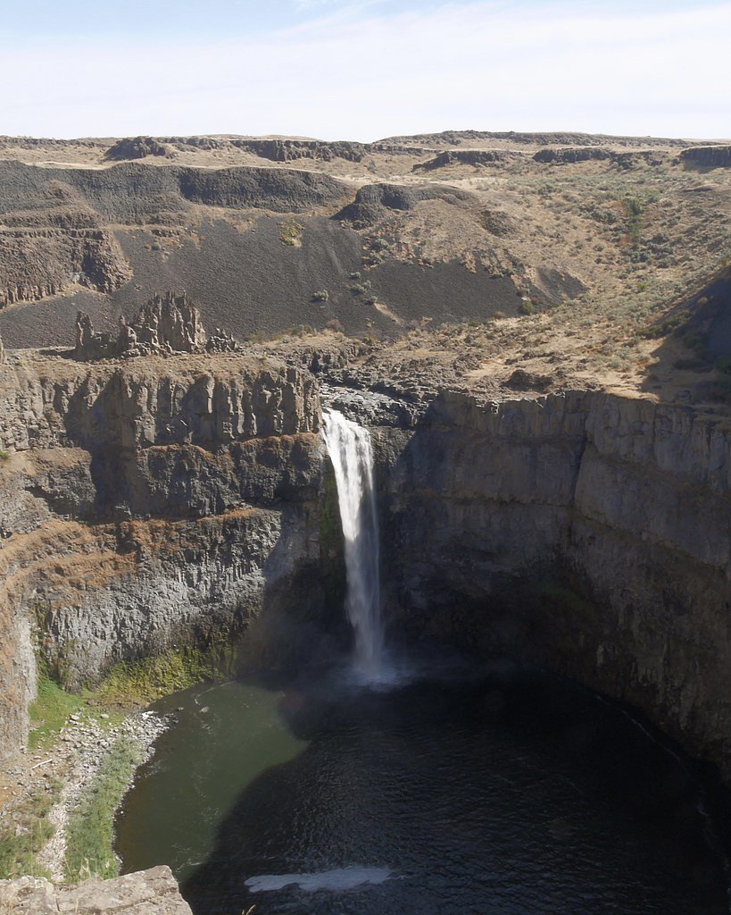
Palouse Falls
Washington • 198 ft
By Armen Suny · Last verified Mar 2026
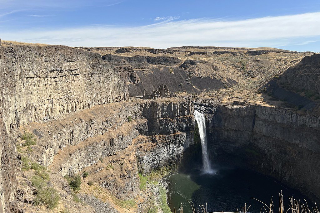

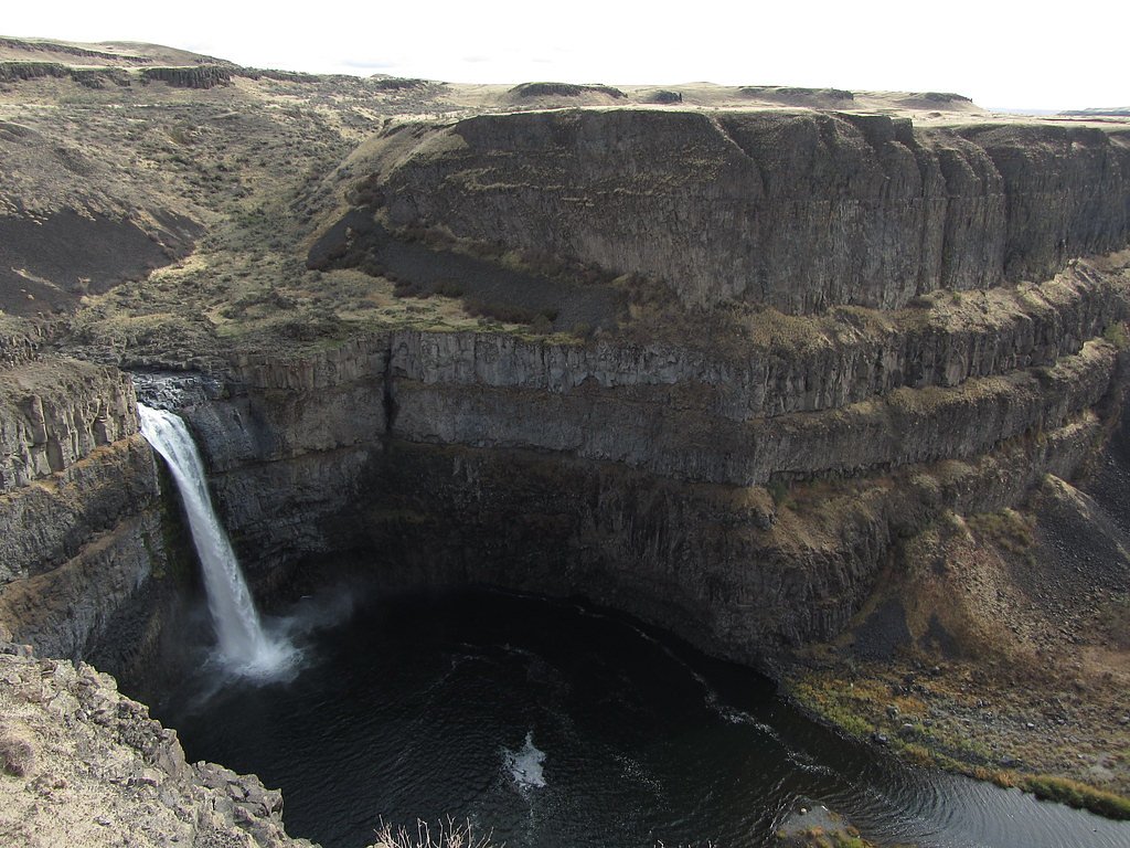
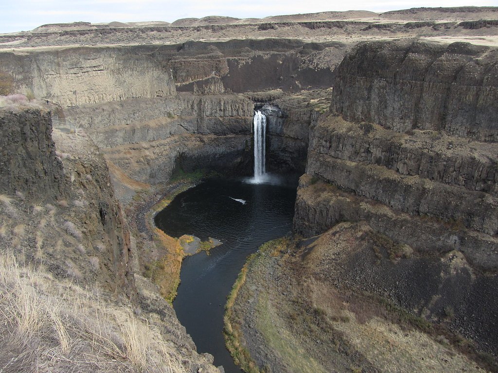

Photo Credits (5)
Difficulty
Moderate
Trail Length
2.4 miles
Trail Type
Out And Back
Elevation Gain
350 ft
About Palouse Falls
Palouse Falls plunges approximately 198–200 feet (about 61 m) on the Palouse River in southeast Washington, sitting roughly four miles (6 km) upstream of where the Palouse meets the Snake River. The falls are set within the 94-acre Palouse Falls State Park, and the scene includes an upper cascade of about 20 feet (6 m) located roughly 1,000 feet (300 m) north-northwest of the main drop, as well as the dramatic lower plunge. These features combine to make the park a compact but rewarding destination for day visitors and photographers. Trails in the state park lead to designated viewpoints that frame the main plunge and the river corridor below. If you’re planning to camp nearby, Lyons Ferry Marina is the closest campground, about 8.62 km away, making Palouse Falls an easy addition to a regional loop of scenic stops along the Snake and Palouse rivers.
The Setting
Palouse Falls sits at 719 feet along the Palouse River, in the foothills of Washington. At 198 feet, it is among the taller waterfalls in Washington.
Height: 198 feet
Trail & Hike Details
The Approach
The moderate 2.4-mile out-and-back trail gains 350 feet of elevation on the way to the falls.
Trail Description
The primary route to the Palouse Falls overlook is an established out-and-back trail of about 2.4 miles round-trip with roughly 350 feet of elevation gain; the route is typically rated moderate. The trail delivers hikers to a designated viewpoint that looks out over the main 198-foot fall and downstream canyon. Surface, grade, and formal trail class details from a USFS trail listing are not provided in the supplied data; visitors should expect a maintained park path to the overlook and follow posted signs and stay within designated areas for the best views and safety.
What to Expect
The falls plunge 198 feet. Dogs are welcome.
Accessibility
The trail is not wheelchair accessible. Uneven terrain and elevation changes require steady footing.
Frequently Asked Questions
🐶 Are Dogs Allowed at Palouse Falls?
✅ Dogs are allowed
Are There Any Fees or Permits Required?
🤑 Fee: $10.00
🏊 Is There Swimming at Palouse Falls?
❌ Swimming is not allowed
When to Visit
Spring is the best time to visit, as the waterfall is most impressive during this season. However, it is a year-round destination with unique beauty in every season.
Seasonal Access
The best time to visit is Spring, Summer, Fall, and Winter.
Safety Information
Stay on designated trails and avoid unmaintained paths, as the terrain can be unstable and dangerous. The canyon edges are steep and unfenced in some areas. Exercise caution, especially with children and pets.
Current Water Conditions
85 ft³/s
Current discharge — how much water is flowing
Lower than usual for this time of year
Based on 92 years of record
3.57 ft
Water depth at gauge
7-Day Discharge Trend
What does this mean for your visit?
Flow is lower than usual for this time of year.
About This Gauge
This gauge is on a nearby waterway and may not reflect exact conditions at the falls.
7-Day Flow Outlook
Based on the USGS gauge PALOUSE RIVER AT HOOPER, WA (12 km away).
Today
Barely Flowing
84 cfs
5/10Tomorrow
Barely Flowing
77 cfs
4/10Mon
Barely Flowing
84 cfs
3/10Tue
Barely Flowing
77 cfs
5/10Wed
Barely Flowing
71 cfs
5/10Thu
Barely Flowing
70 cfs
5/10Fri
Barely Flowing
70 cfs
3/10Best window: Today — barely flowing flow, partly sunny (trip score 5/10).
Best time of year: this gauge typically runs highest from early February to early May, peaking in March.
How we calculate this
This is a transparent outlook, not a precise forecast. We take the waterfall's current flow strength (how it ranks against its historical normal for today, from the nearest USGS stream gauge), carry that ranking forward along the gauge's seasonal curve, and nudge it for forecast rain. Confidence is highest for the next day or two and falls further out. Always check official conditions and your own judgment before visiting — high flows can be dangerous.
Know when to go.
Get a free email alert when waterfalls near Washtucna hit peak flow. We only send when conditions are worth the trip — no weekly newsletters, no spam.
Weather Forecast
Location & Access
Getting There
Palouse Falls is located in Palouse Falls State Park, approximately 23 miles southwest of Washtucna, Washington. It is accessible via Palouse Falls Road, which is a paved and gravel road leading to the park.
Get Directions on Google MapsParking
There is a designated parking area at Palouse Falls State Park, which can accommodate cars and small RVs. Parking may fill up during peak seasons, so arriving early is recommended.
Elevation
719 feet above sea level
Coordinates
46.663479° N, -118.223577° W
Visitor Tips & Gear
Visit in the spring when the waterfall is at its fullest due to snowmelt. Bring water, sunscreen, and sturdy shoes if you plan to explore beyond the main viewpoint. Cell service is limited, so plan accordingly.
As an Amazon Associate, we earn from qualifying purchases.
With 2.4 miles and 350 ft of elevation gain, sturdy boots and trekking poles will help on this moderate trail. Icy conditions are common in winter — traction cleats are a smart addition.

Columbia Watertight II Rain Jacket
Packs into its own pocket, seam-sealed, and keeps you dry from spray and surprise rain.

Polarized Sunglasses (Knockaround)
Cuts glare off the water so you actually see the falls — and your photos turn out better too.

Earth Pak Waterproof Dry Bag
Keeps your phone and gear dry when waterfall mist soaks everything else.

Waterproof Phone Pouch (AiRunTech)
Cheap insurance — take photos right next to the falls without killing your phone.

Timberland Euro Sprint Mid Waterproof
Trusted waterproof boot with premium leather and grippy rubber sole — reliable on rocky, wet trails.

TrailBuddy Trekking Poles
Lightweight aluminum, cork grips, and flip-locks that actually hold — a best-seller for good reason.
Where to Stay
Browse vacation cabins and private rentals nearby
Unique outdoor stays — tents, yurts, and treehouses
Rent a campervan or RV for your waterfall road trip
Some links are affiliate links. We may earn a commission at no extra cost to you.
Nearby Campground
Lyons Ferry Marina
5.4 miles away · 0 sites
This recreation area is part of Lake West
Book on Recreation.govNearby Hot Springs
Hot springs near Washtucna, Washington
Looking for a soak after your hike? Explore more hot springs near Washtucna, Washington on SoakingSprings.
Explore Washington springsAdditional Information
Nearby Attractions
Nearby attractions include Lyons Ferry State Park and the Snake River. The surrounding area also offers opportunities for birdwatching and photography.
Wildlife
The area is home to various bird species, including hawks and eagles, as well as small mammals and reptiles.
Cities near Palouse Falls
Writing about Palouse Falls? Embed this waterfall on your site for free.