Difficulty
Moderate
Trail Length
2.4 miles
Trail Type
Out And Back
Elevation Gain
350 ft
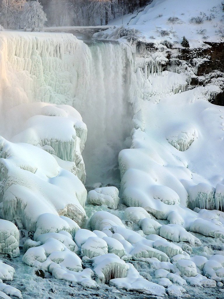
About Oskonsa Falls
Oskonsa Falls is a tucked-away waterfall in New York that offers a peaceful, green setting for hikers and photographers. Because it’s lesser-known, visits often feel private — a quiet cascade framed by woodland rather than a crowded viewpoint. The falls are an inviting reward for a short hike and are especially appealing to anyone looking for a low-key nature escape. The falls are reached by a 2.4-mile out-and-back trail that gains about 350 feet and is generally rated moderate. The route can be uneven in places, so sturdy footwear and a bit of care on the approach are recommended. The nearest developed camping is South Shore Recreation Area, roughly 19.4 km away; check local access and trail conditions before you go to plan your visit.
The Setting
Oskonsa Falls sits at 1,306 feet along the Tuscarora Creek, in the foothills of New York.
Trail & Hike Details
The Approach
The moderate 2.4-mile out-and-back trail gains 350 feet of elevation on the way to the falls.
Trail Description
Length: 2.4 miles round-trip (out-and-back). Elevation gain: ~350 feet. Difficulty: moderate. Official surface, grade, and trail class data are not listed for this route; hikers should expect natural footpaths with uneven sections, roots and rocks, and a steady moderate climb on the approach. The hike is non-technical but requires sure footing in wet or slippery conditions. No USFS trail name/number is available in the provided data — confirm current trail conditions and access before heading out.
What to Expect
Expect a quiet and scenic waterfall surrounded by natural beauty. The area may be less developed, so plan accordingly for a more rugged experience.
Accessibility
The trail is not wheelchair accessible. Uneven terrain and elevation changes require steady footing.
Frequently Asked Questions
🐶 Are Dogs Allowed at Oskonsa Falls?
❌ Dogs are not allowed
Are There Any Fees or Permits Required?
🆖 No fees required
🏊 Is There Swimming at Oskonsa Falls?
❌ Swimming is not allowed
When to Visit
Spring and early summer are typically the best times to visit, as water flow is likely to be higher due to snowmelt and rainfall.
Seasonal Access
The best time to visit is Spring, Summer, and Fall. Winter access may be limited.
Safety Information
Trails may be unmarked or poorly maintained. Watch for slippery rocks near the waterfall and be cautious of changing weather conditions.
Current Water Conditions
18 ft³/s
Current discharge — how much water is flowing
About average for this time of year
Based on 25 years of record
2.62 ft
Water depth at gauge
7-Day Discharge Trend
What does this mean for your visit?
Flow is about average for this time of year.
About This Gauge
7-Day Flow Outlook
Based on the USGS gauge TUSCARORA CREEK ABOVE SOUTH ADDISON NY (7 km away).
Today
Barely Flowing
18 cfs
4/10Tomorrow
Low
14 cfs
3/10Wed
Low
15 cfs
6/10Thu
Barely Flowing
11 cfs
5/10Fri
Low
11 cfs
3/10Sat
Moderate
12 cfs
4/10Sun
Moderate
11 cfs
4/10Best window: Wed — low flow, sunny (trip score 6/10).
Best time of year: this gauge typically runs highest from early March to late April, peaking in April.
How we calculate this
This is a transparent outlook, not a precise forecast. We take the waterfall's current flow strength (how it ranks against its historical normal for today, from the nearest USGS stream gauge), carry that ranking forward along the gauge's seasonal curve, and nudge it for forecast rain. Confidence is highest for the next day or two and falls further out. Always check official conditions and your own judgment before visiting — high flows can be dangerous.
Know when to go.
Get a free email alert when waterfalls near Elkland hit peak flow. We only send when conditions are worth the trip — no weekly newsletters, no spam.
Weather Forecast
Location & Access
Getting There
Oskonsa Falls is located in a remote area of New York. Access may require navigating rural roads, and specific directions should be confirmed before visiting.
Get Directions on Google MapsParking
Parking availability is unclear, but visitors may need to park along nearby roads or at designated trailheads if available.
Elevation
1,306 feet above sea level
Coordinates
42.133406° N, -77.306924° W
Visitor Tips & Gear
Bring sturdy footwear, as trails may be unmaintained. Check weather conditions before visiting, and carry a map or GPS device as signage may be limited.
As an Amazon Associate, we earn from qualifying purchases.
With 2.4 miles and 350 ft of elevation gain, sturdy boots and trekking poles will help on this moderate trail. Sun exposure on the trail makes good sun protection a must in summer.

Columbia Watertight II Rain Jacket
Packs into its own pocket, seam-sealed, and keeps you dry from spray and surprise rain.

Earth Pak Waterproof Dry Bag
Keeps your phone and gear dry when waterfall mist soaks everything else.

Waterproof Phone Pouch (AiRunTech)
Cheap insurance — take photos right next to the falls without killing your phone.

Timberland Euro Sprint Mid Waterproof
Trusted waterproof boot with premium leather and grippy rubber sole — reliable on rocky, wet trails.

TrailBuddy Trekking Poles
Lightweight aluminum, cork grips, and flip-locks that actually hold — a best-seller for good reason.

Polarized Sunglasses (Knockaround)
Cuts glare off the water so you actually see the falls — and your photos turn out better too.
Where to Stay

Hampton Inn Corning/Painted Post

Quality Inn Corning

Fairfield Inn Corning Riverside

Staybridge Suites Corning by IHG
Browse vacation cabins and private rentals nearby
Unique outdoor stays — tents, yurts, and treehouses
Rent a campervan or RV for your waterfall road trip
Some links are affiliate links. We may earn a commission at no extra cost to you.
Nearby Campground
SOUTH SHORE RECREATION AREA
12.1 miles away · 3 sites
Overview South Shore Recreation Area is located on the south side of the Cowanesque Lake along State Route 49, just five miles west of Lawrenceville, Pennsylvania. The area is easily accessible from Route 15 and offers a great location for boating, picnicking and fishing.Recreation Cowanesque Lake offers a variety of outdoor activities including boating and fishing. A variety of native fish inhabits the area's streams and lakes. The North and South Tailrace areas provide access for fishing below
Book on Recreation.govAdditional Information
Nearby Attractions
Explore other natural attractions in the surrounding area, such as state parks or hiking trails.
Wildlife
The area may host a variety of wildlife, including birds and small mammals. Be mindful of your surroundings.
Cities near Oskonsa Falls
Nearby Waterfalls
Writing about Oskonsa Falls? Embed this waterfall on your site for free.