ʻOloʻupena Falls
Hawaii • 900 ft
By Armen Suny · Last verified May 2026
Difficulty
Moderate
Trail Length
2.4 miles
Trail Type
Out And Back
Elevation Gain
350 ft
About ʻOloʻupena Falls
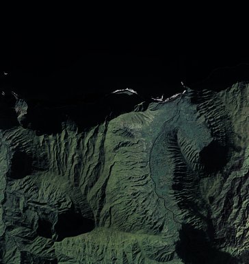
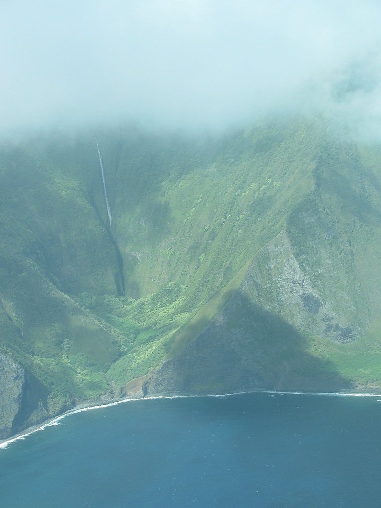
Oloʻupena Falls plunges from the northeastern cliffs of Molokaʻi, dropping about 2,953 feet (900 m) and making it unofficially one of the tallest waterfalls in the world and the highest in the United States. The falls form where a short, seasonal stream spills over one of the planet’s tallest sea-side cliffs, carving a deep groove in the rock between the Pelekunu and Wailau valleys. The cascade’s dramatic height and remote coastal setting create a showpiece best appreciated from the water or the air, where the full tiered drop can be seen against the island’s rugged shoreline. The falls lie within the Oloku‘i Natural Area Reserve, owned and managed by the State Department of Land and Natural Resources (SDNR) and designated SCA. Because the area is coastal, steep, and protected, there is no developed or maintained public approach to the base—viewing is typically done from boats or aircraft. Visitors should respect the reserve’s managed status and plan any sea- or air-based trips with licensed operators who are familiar with local regulations and conditions.
The Setting
ʻOloʻupena Falls sits at 1,289 feet within Oloku'i Natural Area Reserve, in the foothills of Hawaii. At 900 feet, it is among the taller waterfalls in Hawaii.
Height: 900 feet
Nearby Falls Worth Visiting
Puʻukaʻōkū Falls, the tallest waterfall in Hawaii at 2,756 feet, lies 0.3 miles to the east. Also nearby: Kahiwa Falls (1749 ft, 3.2 mi) and Pāpalaua Falls (1200 ft, 3.3 mi).
Trail & Hike Details
The Approach
The moderate 2.4-mile out-and-back trail gains 350 feet of elevation on the way to the falls.
Trail Description
There is no maintained trail to Oloʻupena Falls; the falls descend sheer sea cliffs and are not accessible by a conventional hiking path. They can only be reliably viewed from the ocean or from the air. Some route information reported for approaches in the general area lists a 2.4-mile out-and-back distance with roughly 350 feet of elevation gain and a “moderate” difficulty rating, but this reflects unmarked, rugged terrain rather than an official trail surface or USFS-maintained route. In short: no formal surface, no signed grade/class data, and any land-based approach would be off-trail, steep, and potentially hazardous—plan to view by boat or air and follow local management guidance from SDNR.
What to Expect
The falls plunge a dramatic 900 feet.
Accessibility
The trail is not wheelchair accessible. Uneven terrain and elevation changes require steady footing.
Frequently Asked Questions
🐶 Are Dogs Allowed at ʻOloʻupena Falls?
❌ Dogs are not allowed
Are There Any Fees or Permits Required?
🤑 Fee: $0.00
🏊 Is There Swimming at ʻOloʻupena Falls?
❌ Swimming is not allowed
When to Visit
The falls can be visited year-round, but weather conditions are typically more favorable during the dry season (April to October).
Seasonal Access
The best time to visit is Spring, Summer, Fall, and Winter. Heavy rains during wet season (November through March) bring higher flow but can make trails slippery.
Safety Information
Weather conditions can change rapidly, especially during the rainy season. Helicopter and boat tours may be canceled or delayed due to safety concerns. Always follow the instructions of your tour operator.
Current Water Conditions
0 ft³/s
Current discharge — how much water is flowing
About average for this time of year
Based on 29 years of record
2.62 ft
Water depth at gauge
7-Day Discharge Trend
What does this mean for your visit?
Flow is about average for this time of year.
About This Gauge
7-Day Flow Outlook
Based on the USGS gauge EF Kawela Gulch nr Kamalo, Molokai, HI (7 km away).
Today
Moderate
0 cfs
5/10Tomorrow
Moderate
0 cfs
5/10Wed
Moderate
0 cfs
5/10Thu
Moderate
0 cfs
5/10Fri
Moderate
0 cfs
5/10Sat
Moderate
0 cfs
5/10Sun
Moderate
0 cfs
5/10Best window: Today — moderate flow, chance rain showers (trip score 5/10).
Best time of year: this gauge typically runs highest from late November to late December, peaking in December.
How we calculate this
This is a transparent outlook, not a precise forecast. We take the waterfall's current flow strength (how it ranks against its historical normal for today, from the nearest USGS stream gauge), carry that ranking forward along the gauge's seasonal curve, and nudge it for forecast rain. Confidence is highest for the next day or two and falls further out. Always check official conditions and your own judgment before visiting — high flows can be dangerous.
Know when to go.
Get a free email alert when waterfalls near Ualapue hit peak flow. We only send when conditions are worth the trip — no weekly newsletters, no spam.
Weather Forecast
Location & Access
Getting There
ʻOloʻupena Falls is located on the northeastern coast of Molokai, Hawaii. It is not accessible by road or hiking trails. Visitors typically view the falls via helicopter tours or boat excursions.
Get Directions on Google MapsParking
There is no parking available as the falls are not accessible by land.
Elevation
1,289 feet above sea level
Coordinates
21.160655° N, -156.856410° W
Land Management
Managed by SDNR
Visitor Tips & Gear
Book a helicopter or boat tour in advance to ensure availability. Morning tours may offer better visibility due to calmer weather conditions. Bring a camera to capture the stunning views.
As an Amazon Associate, we earn from qualifying purchases.
With 2.4 miles and 350 ft of elevation gain, sturdy boots and trekking poles will help on this moderate trail. Icy conditions are common in winter — traction cleats are a smart addition.

Columbia Watertight II Rain Jacket
Packs into its own pocket, seam-sealed, and keeps you dry from spray and surprise rain.

Earth Pak Waterproof Dry Bag
Keeps your phone and gear dry when waterfall mist soaks everything else.

Waterproof Phone Pouch (AiRunTech)
Cheap insurance — take photos right next to the falls without killing your phone.

Timberland Euro Sprint Mid Waterproof
Trusted waterproof boot with premium leather and grippy rubber sole — reliable on rocky, wet trails.

TrailBuddy Trekking Poles
Lightweight aluminum, cork grips, and flip-locks that actually hold — a best-seller for good reason.

Kahtoola MICROspikes
Cult-favorite traction cleats that grip ice and wet rock — essential for winter waterfall hikes.
Where to Stay

High-End Resort Condo Nestled on Molokai Shoreline

OUTRIGGER Kāʻanapali Beach Resort

Kahana Beach Vacation Club

Royal Lahaina Resort & Bungalows
Browse vacation cabins and private rentals nearby
Unique outdoor stays — tents, yurts, and treehouses
Rent a campervan or RV for your waterfall road trip
Some links are affiliate links. We may earn a commission at no extra cost to you.
Additional Information
Nearby Attractions
Other notable attractions on Molokai include Halawa Valley, Kalaupapa National Historical Park, and Papohaku Beach.
Wildlife
The area around the falls is home to native Hawaiian birds and marine life, which may be visible during boat tours.
Cities near ʻOloʻupena Falls
Nearby Waterfalls
Writing about ʻOloʻupena Falls? Embed this waterfall on your site for free.