Difficulty
Moderate
Trail Length
2.4 miles
Trail Type
Out And Back
Elevation Gain
350 ft
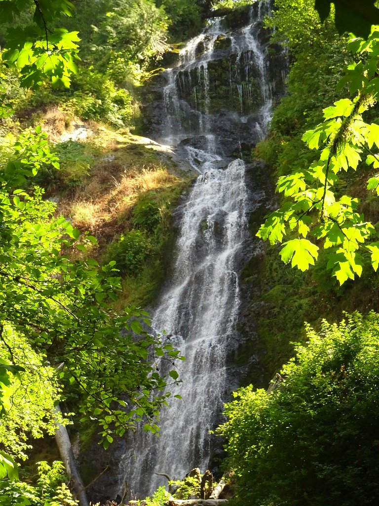
About Nenamusa Falls
Nenamusa Falls is a quietly scenic waterfall tucked into the forests of the Siuslaw National Forest and managed by the U.S. Forest Service. The falls are a great choice for hikers seeking a low-traffic, peaceful outing: the approach follows a pleasant forest corridor and finishes at a naturally framed cascade that feels tucked away from busier recreation areas. The access hike is a 2.4-mile out-and-back with about 350 feet of elevation gain and is typically rated moderate, so it’s well suited to half-day hikers who are comfortable on uneven ground. Because the site sits on USFS land, it’s easy to combine a visit with nearby dispersed or group camping—Rocky Bend Group Campground is just 0.79 km away—making Nenamusa Falls an inviting option for an overnight trip. Plan on sturdy footwear and layers; trail conditions can be damp and the forest canopy keeps much of the approach shaded, which enhances the tranquil, tucked-away feel of the waterfall.
The Setting
Nenamusa Falls sits at 758 feet within Siuslaw National Forest, fed by the Tucca Creek, in the foothills of Oregon.
Nearby Falls Worth Visiting
Munson Creek Falls (319 ft) lies 11.4 miles to the northwest.
Trail & Hike Details
The Approach
The moderate 2.4-mile out-and-back trail gains 350 feet of elevation on the way to the falls.
Trail Description
The trail to Nenamusa Falls is an approximately 2.4-mile out-and-back route with roughly 350 feet of elevation gain and a moderate difficulty rating. The U.S. Forest Service manages the area but does not list a specific trail name or number for this approach; trail information from the managing unit (Siuslaw National Forest) indicates the route is established but not heavily developed. USFS listings do not specify a formal surface, grade, or technical class for this route. Hikers should therefore expect natural, uneven forest tread and be prepared for potentially muddy or slick sections near the creek and falls. Sturdy footwear, basic navigation awareness, and moderate fitness will make the hike enjoyable; with Rocky Bend Group Campground less than a kilometer away, it’s easy to camp nearby before or after your visit.
What to Expect
Expect a peaceful and scenic experience surrounded by Oregon's natural beauty. The area may be less crowded compared to more popular waterfalls.
Accessibility
The trail is not wheelchair accessible. Uneven terrain and elevation changes require steady footing.
Frequently Asked Questions
🐶 Are Dogs Allowed at Nenamusa Falls?
❌ Dogs are not allowed
Are There Any Fees or Permits Required?
🆖 No fees required
🏊 Is There Swimming at Nenamusa Falls?
❌ Swimming is not allowed
When to Visit
Spring and early summer are typically the best times to visit, as water flow is likely to be at its peak.
Seasonal Access
The best time to visit is Spring, Summer, and Fall. Winter access may be limited. Check with Siuslaw National Forest for seasonal road closures.
Safety Information
Visitors should be cautious of slippery rocks, uneven terrain, and potential wildlife encounters. Always stay on marked trails if available.
Current Water Conditions
3 ft³/s
Current discharge — how much water is flowing
About average for this time of year
Based on 40 years of record
10.57 ft
Water depth at gauge
7-Day Discharge Trend
What does this mean for your visit?
Flow is about average for this time of year.
About This Gauge
This gauge is on a nearby waterway and may not reflect exact conditions at the falls.
7-Day Flow Outlook
Based on the USGS gauge TUCCA CREEK NEAR BLAINE, OR. (10 km away).
Today
Barely Flowing
3 cfs
3/10Tomorrow
Low
3 cfs
4/10Sun
Low
3 cfs
4/10Mon
Low
3 cfs
4/10Tue
Low
3 cfs
4/10Wed
Barely Flowing
2 cfs
4/10Thu
Barely Flowing
2 cfs
4/10Best window: Tomorrow — low flow, rain showers (trip score 4/10).
Best time of year: this gauge typically runs highest from late December to late January, peaking in January.
How we calculate this
This is a transparent outlook, not a precise forecast. We take the waterfall's current flow strength (how it ranks against its historical normal for today, from the nearest USGS stream gauge), carry that ranking forward along the gauge's seasonal curve, and nudge it for forecast rain. Confidence is highest for the next day or two and falls further out. Always check official conditions and your own judgment before visiting — high flows can be dangerous.
Know when to go.
Get a free email alert when waterfalls near Grand Ronde hit peak flow. We only send when conditions are worth the trip — no weekly newsletters, no spam.
Weather Forecast
Location & Access
Getting There
Nenamusa Falls is located in Oregon, but specific directions to the trailhead or access point are not widely documented. Visitors may need to consult local resources or maps for precise guidance.
Get Directions on Google MapsParking
Parking availability is unclear, but visitors should expect limited or informal parking near the trailhead.
Elevation
758 feet above sea level
Coordinates
45.242888° N, -123.597056° W
Land Management
Managed by USFS
Visitor Tips & Gear
Bring a map or GPS device as the trail may not be well-marked. Check weather conditions before visiting, and be prepared for potential muddy or slippery sections.
As an Amazon Associate, we earn from qualifying purchases.
With 2.4 miles and 350 ft of elevation gain, sturdy boots and trekking poles will help on this moderate trail. Sun exposure on the trail makes good sun protection a must in summer.

Columbia Watertight II Rain Jacket
Packs into its own pocket, seam-sealed, and keeps you dry from spray and surprise rain.

Earth Pak Waterproof Dry Bag
Keeps your phone and gear dry when waterfall mist soaks everything else.

Waterproof Phone Pouch (AiRunTech)
Cheap insurance — take photos right next to the falls without killing your phone.

Timberland Euro Sprint Mid Waterproof
Trusted waterproof boot with premium leather and grippy rubber sole — reliable on rocky, wet trails.

TrailBuddy Trekking Poles
Lightweight aluminum, cork grips, and flip-locks that actually hold — a best-seller for good reason.

Polarized Sunglasses (Knockaround)
Cuts glare off the water so you actually see the falls — and your photos turn out better too.
Where to Stay

Holiday Inn Express & Suites Lincoln City by IHG

Best Western McMinnville Inn

The Tillamook Inn

Best Western University Inn and Suites
Browse vacation cabins and private rentals nearby
Unique outdoor stays — tents, yurts, and treehouses
Rent a campervan or RV for your waterfall road trip
Some links are affiliate links. We may earn a commission at no extra cost to you.
Nearby Campground
Rocky Bend Group Campground
0.5 miles away · 1 sites
Overview Nestled on the banks of the Nestucca River, Rocky Bend Group Campground is ideal for family gatherings and group events. The site is located on Upper Nestucca River Road 16 miles east of Beaver, Oregon. This group camp offers a picturesque setting, with plenty of recreation opportunity. Recreation Anglers enjoy casting a line into the Nestucca River, where steelhead and salmon can be caught during open fishing season. The campground is near hiking trails and waterfalls. Facilities Group
Book on Recreation.govAdditional Information
Nearby Attractions
Other waterfalls and hiking trails in Oregon's scenic forests may be nearby, but specific attractions are not documented.
Wildlife
The area may host typical Oregon wildlife such as birds, deer, and small mammals.
Cities near Nenamusa Falls
Nearby Waterfalls
Writing about Nenamusa Falls? Embed this waterfall on your site for free.