
Nambe Falls
By Armen Suny · Last verified Sep 2026
LiDAR & 3D terrain


Photo Credits (5)
Difficulty
Easy
Trail Length
1.5 miles
Trail Type
Out And Back
About Nambe Falls
Nambe Falls is a stunning two-tiered waterfall located on the Nambe Pueblo in New Mexico. It is a popular destination for its scenic beauty and peaceful surroundings, offering visitors a chance to enjoy nature and the unique landscape of the region.
The Setting
Nambe Falls sits at 6,722 feet within Nambe Pueblo, in the high mountains of New Mexico.
Trail & Hike Details
Trail Description
The trail to Nambe Falls is short and relatively easy, making it accessible for most visitors. There are two main routes: one that leads to the base of the falls and another that provides a view from above. The trail is well-maintained but may have some rocky sections.
What to Expect
Swimming is permitted.
Accessibility
The trail is not wheelchair accessible. Uneven terrain and elevation changes require steady footing.
Frequently Asked Questions
🐶 Are Dogs Allowed at Nambe Falls?
❌ Dogs are not allowed
Are There Any Fees or Permits Required?
🤑 Fee: $0.00
Permit required
A permit is required to access Nambe Falls, which is included in the entry fee to the recreation area.
🏊 Is There Swimming at Nambe Falls?
✅ Swimming is allowed
When to Visit
The best time to visit Nambe Falls is during the spring and summer months when water flow is typically at its peak. Fall is also a great time to visit for cooler weather and colorful foliage.
Seasonal Access
The best time to visit is Spring, Summer, and Fall. Access roads and trails may close during winter due to snow. Watch for flash flood warnings during monsoon season (July through September).
Safety Information
Exercise caution near the water, as rocks can be slippery. Be aware of changing weather conditions and follow all posted guidelines. Respect the cultural significance of the area and adhere to Nambe Pueblo regulations.
Current Water Conditions
11 ft³/s
Current discharge — how much water is flowing
Higher than usual for this time of year
Based on 46 years of record
0.74 ft
Water depth at gauge
7-Day Discharge Trend
What does this mean for your visit?
The water is flowing higher than usual for this time of year.
About This Gauge
7-Day Flow Outlook
Based on the USGS gauge RIO NAMBE BELOW NAMBE FALLS DAM NEAR NAMBE, NM (0 km away).
Today
Moderate
12 cfs
4/10Tomorrow
Moderate
14 cfs
4/10Sat
Moderate
13 cfs
4/10Sun
Moderate
13 cfs
4/10Mon
Moderate
12 cfs
5/10Tue
Moderate
11 cfs
8/10Wed
Low
9 cfs
6/10Best window: Tue — moderate flow, sunny (trip score 8/10).
Best time of year: this gauge typically runs highest from mid April to late July, peaking in June.
How we calculate this
This is a transparent outlook, not a precise forecast. We take the waterfall's current flow strength (how it ranks against its historical normal for today, from the nearest USGS stream gauge), carry that ranking forward along the gauge's seasonal curve, and nudge it for forecast rain. Confidence is highest for the next day or two and falls further out. Always check official conditions and your own judgment before visiting — high flows can be dangerous.
Know when to go.
Get a free email alert when waterfalls near Rio en Medio hit peak flow. We only send when conditions are worth the trip — no weekly newsletters, no spam.
Weather Forecast
The Terrain, Seen by LiDAR
Aircraft-mounted lasers measured this ground to within inches. Trees and buildings are digitally stripped away, leaving the bare shape of the land the water has carved.
The ground through the falls loses about 269 feet in steep steps rather than one leap. The ground at the falls is roughly 6,741 feet above sea level.
The whole reach is steep: about 80 feet of descent in the 500 feet above the falls and another 157 feet in the 500 feet below. The falls face southwest and glow in afternoon and evening light.
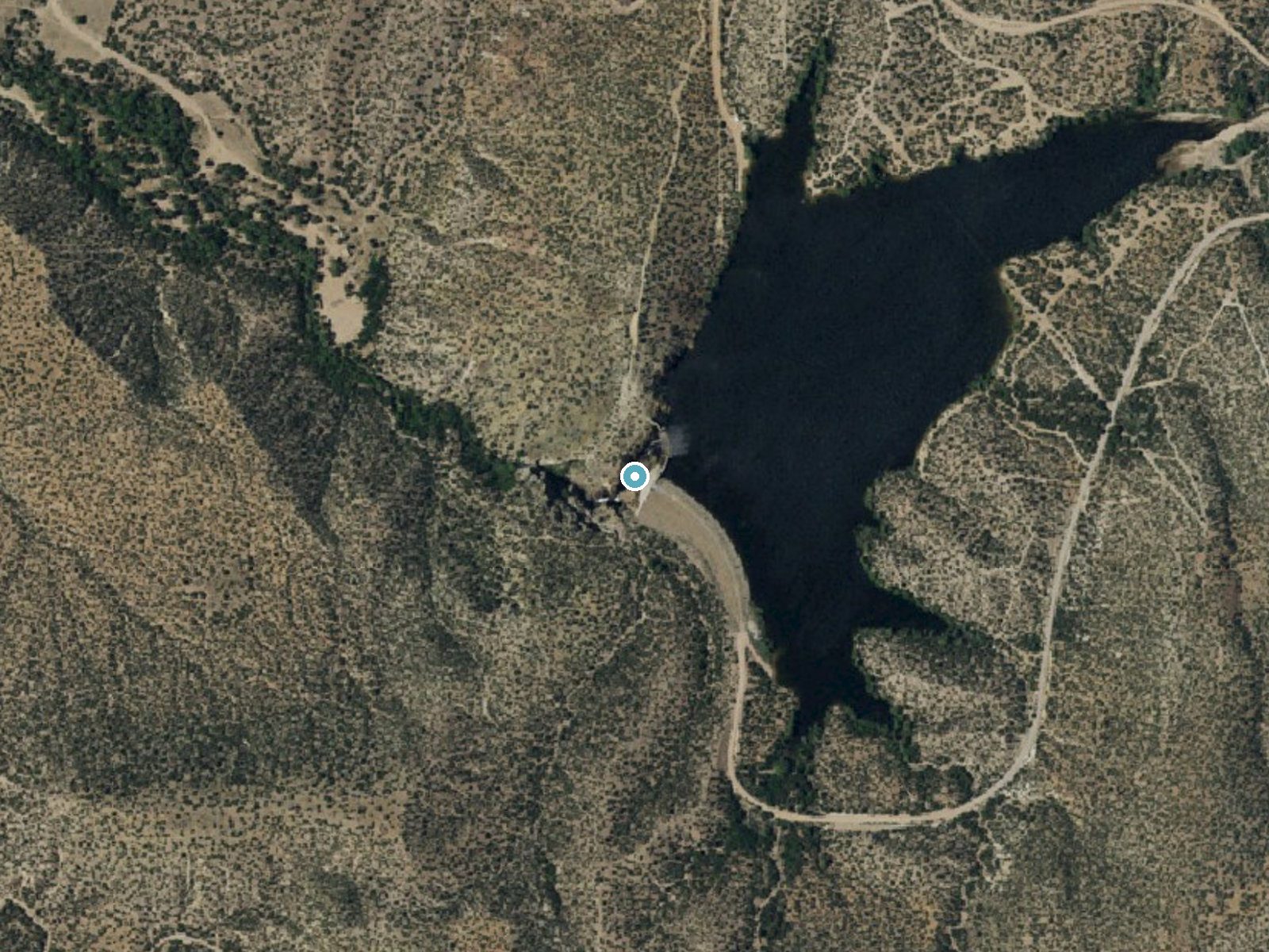
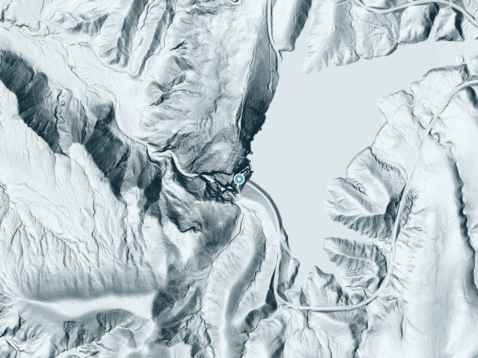
Drag to compare. The dot marks the waterfall. The frame is about a mile across.
- Ground elevation
- 6,741 feet
- Measured by 1-meter lidar
- Drop at the falls
- About 269 feet
- Change in ground height within ~250 feet of the falls
- Faces
- Southwest
- Glows in afternoon and evening light.
A slice through the lidar ground surface, from above the falls to downstream (heading southwest).
Elevation data: USGS 3D Elevation Program. Aerial imagery: USGS The National Map. Public domain.
Location & Access
Getting There
Nambe Falls is located on the Nambe Pueblo, approximately 25 miles north of Santa Fe, New Mexico. Visitors can access the falls by driving to the Nambe Falls Recreation Area, which is managed by the Nambe Pueblo.
Get Directions on Google MapsParking
Parking is available at the Nambe Falls Recreation Area. A fee is typically required for entry and parking.
Hours
Elevation
6,722 feet above sea level
Coordinates
35.845583° N, -105.906410° W
Land Management
Managed by TRIB
Visitor Tips & Gear
Arrive early to avoid crowds, especially during weekends and holidays. Bring water and wear sturdy shoes, as some sections of the trail may be uneven. Respect the rules and guidelines set by the Nambe Pueblo.
This trail sits at 6,722 ft above sea level
Elevated TrailUV radiation is roughly 27% stronger at this elevation than at sea level, and the dry air accelerates dehydration. Extra sun protection and fluids go a long way.
As an Amazon Associate, we earn from qualifying purchases.

Coppertone Sport SPF 50 Sunscreen
UV intensity jumps ~4% per 1,000 ft — at this elevation you can burn in half the time.

Sun Bum SPF 30 Lip Balm (3-Pack)
Lips have almost no natural UV protection and burn fast in thin, dry mountain air.

Liquid I.V. Electrolyte Packets
You lose moisture ~2x faster at elevation — electrolytes help you absorb water efficiently.

ROCKNIGHT Polarized UV400 Sunglasses
High-altitude glare off rock and water is intense — UV400 lenses block 99%+ of UVA/UVB.
Where to Stay

Hilton Santa Fe Buffalo Thunder

Inn at Vanessie

El Sendero Inn, an Ascend Collection Hotel

Pueblo Bonito Inn
Browse vacation cabins and private rentals nearby
Unique outdoor stays — tents, yurts, and treehouses
Rent a campervan or RV for your waterfall road trip
Some links are affiliate links. We may earn a commission at no extra cost to you.
Nearby Campground
Black Canyon Campground (Santa Fe National Forest, NM)
4.1 miles away · 36 sites
Overview At 8475 feet in elevation, Black Canyon Campground is in a great location to experience some of the finest mountain scenery the Southwest has to offer. The facility is newly renovated and provides access to a variety of outdoor recreational activities. Campers can enjoy warm days and cool weather in the summer months, providing a scenic getaway from the desert heat. Recreation Hikers enjoy a pleasant hiking 1.5-mile trail that loops around the campground and into the surrounding forest.
Book on Recreation.govNearby Hot Springs
Hot springs near Chupadero, New Mexico
Ojo Caliente Hot Springs
Ojo Caliente Hot Springs is a group of geothermal springs at 6,220 feet in Rio Arriba County with roadside access just 30 meter...

Ojo Caliente (Arsenic Spring)
Ojo Caliente's Arsenic Spring discharges at 111°F (40°C confirmed by USGS) through water unusually high in sodium (890 mg/L) an...

Spence Hot Springs
Spence Hot Springs emerges at 7,332 feet in the Santa Fe National Forest with 100°F water — 52°F above the local average. Total...
Mccauley Hot Springs
McCauley Hot Springs emerges at 99 °F within Santa Fe National Forest at a notable 7,360 feet elevation in the Jemez Mountains....
Statue
Statue Spring emerges at 83°F and 6,600 feet elevation in the Carson National Forest, Rio Arriba County, near the community of ...

Sulphur Springs
Sulphur Springs delivers 189°F water inside the Valles Caldera National Preserve at 8,267 feet elevation -- dangerously hot and...
Looking for a soak after your hike? Explore more hot springs near Chupadero, New Mexico on SoakingSprings.
Explore New Mexico springsAdditional Information
Nearby Attractions
Nearby attractions include Santa Fe, Bandelier National Monument, and the Sangre de Cristo Mountains.
Wildlife
The area is home to various wildlife, including birds, deer, and small mammals. Visitors may also see native plants and wildflowers.
Cities near Nambe Falls
Writing about Nambe Falls? Embed this waterfall on your site for free.