Photo Credits (4)
Difficulty
Easy
Trail Length
5.4 miles
Trail Type
Out And Back
Elevation Gain
300 ft
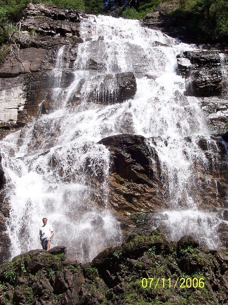
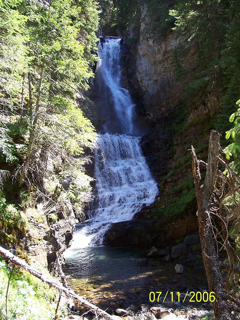
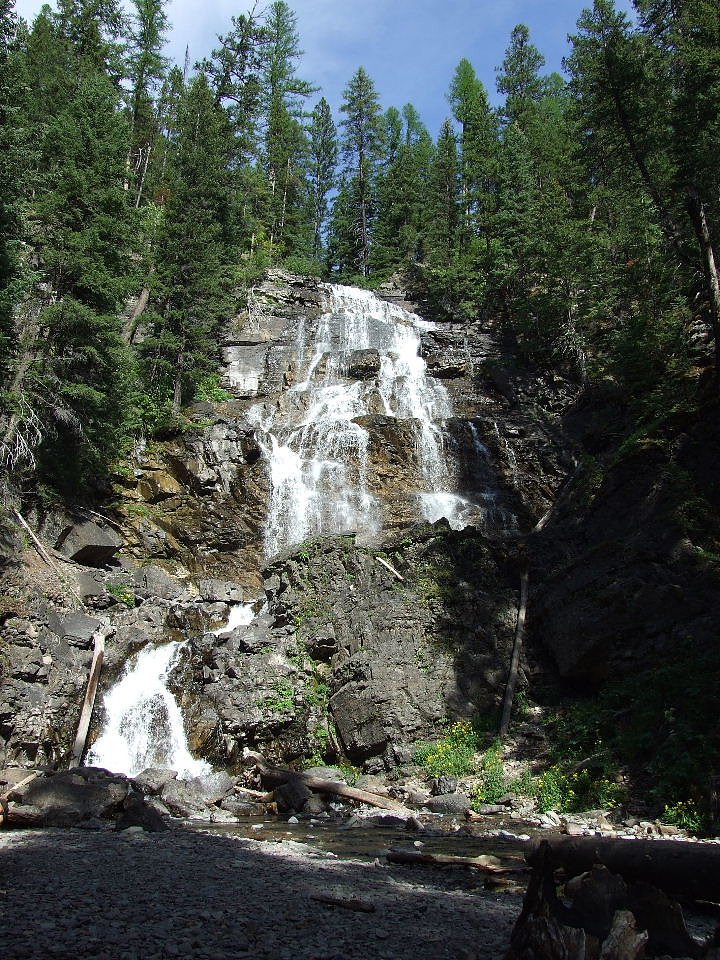
About Morrell Falls
Morrell Falls is a picturesque two-tiered waterfall located in the Lolo National Forest near Seeley Lake, Montana. It is a popular destination for hikers and nature enthusiasts, offering a serene setting surrounded by lush forest and mountain views.
The Setting
Morrell Falls sits at 5,007 feet within Lolo National Forest, fed by the South Fork Jocko River, in the high mountains of Montana.
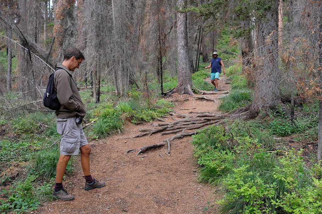
Trail & Hike Details
The Approach
The easy hike follows Morrell Falls (#30), a 5.4-mile out-and-back trail over natural surface. Expect 300 feet of elevation gain with grades of 12-20%. The trail is highly developed (Class 4).
USFS Trail
MORRELL FALLS #30
Trail Class
Highly Developed
Surface
Avg Grade
USFS Segment
2.68 miTrail Description
The trail to Morrell Falls is well-maintained and relatively flat, making it suitable for most hikers. It winds through a scenic forested area with views of Morrell Creek and surrounding mountains. The trail ends at the base of the falls, where visitors can enjoy the stunning two-tiered cascade.
What to Expect
Dogs are welcome.
Accessibility
The trail is not wheelchair accessible. Uneven terrain and elevation changes require steady footing.
Frequently Asked Questions
🐶 Are Dogs Allowed at Morrell Falls?
✅ Dogs are allowed
Are There Any Fees or Permits Required?
🆖 No fees required
🏊 Is There Swimming at Morrell Falls?
❌ Swimming is not allowed
When to Visit
The best time to visit Morrell Falls is late spring through early fall, when the trail is most accessible and the waterfall flow is at its peak. Summer offers the warmest weather, while fall provides beautiful foliage.
Seasonal Access
The best time to visit is Spring, Summer, and Fall. Access roads and trails may close during winter due to snow. Check with Lolo National Forest for seasonal road closures.
Safety Information
Visitors should be prepared for changing weather conditions and carry bear spray. The area around the falls can be slippery, so caution is advised. Check trail conditions before visiting, especially in early spring or after heavy rains.
Current Water Conditions
Based on a USGS gauge 19.6 miles away
119 ft³/s
Current discharge — how much water is flowing
About average for this time of year
Based on 43 years of record
2.13 ft
Water depth at gauge
7-Day Discharge Trend
What does this mean for your visit?
Flow is about average for this time of year.
About This Gauge
This gauge is on a regional waterway. Conditions at the falls may differ, especially after local rain.
7-Day Flow Outlook
Based on the USGS gauge South Fork Jocko River near Arlee MT (32 km away).
Today
Low
136 cfs
3/10Tomorrow
Low
132 cfs
4/10Mon
Low
127 cfs
4/10Tue
Low
125 cfs
4/10Wed
Low
124 cfs
3/10Thu
Low
129 cfs
3/10Fri
Low
128 cfs
3/10Best window: Tomorrow — low flow, rain (trip score 4/10).
Best time of year: this gauge typically runs highest from late April to late July, peaking in June.
How we calculate this
This is a transparent outlook, not a precise forecast. We take the waterfall's current flow strength (how it ranks against its historical normal for today, from the nearest USGS stream gauge), carry that ranking forward along the gauge's seasonal curve, and nudge it for forecast rain. Confidence is highest for the next day or two and falls further out. Always check official conditions and your own judgment before visiting — high flows can be dangerous.
Know when to go.
Get a free email alert when waterfalls near Seeley Lake hit peak flow. We only send when conditions are worth the trip — no weekly newsletters, no spam.
Weather Forecast
Location & Access
Getting There
Morrell Falls is accessed via the Morrell Falls National Recreation Trail, which begins at the Morrell Falls Trailhead. The trailhead is located approximately 6 miles from the town of Seeley Lake, Montana, and is reached by driving on gravel roads. Visitors should check local conditions for road accessibility, especially during spring or after heavy rains.
Get Directions on Google MapsParking
There is a designated parking area at the Morrell Falls Trailhead. Parking is free, but space may be limited during peak seasons.
Elevation
5,007 feet above sea level
Coordinates
47.301048° N, -113.462854° W
Land Management
Managed by USFS
Visitor Tips & Gear
Wear sturdy hiking shoes, as parts of the trail may be muddy or uneven. Bring insect repellent during the summer months, as mosquitoes can be prevalent. Start early in the day to avoid crowds and ensure you have enough daylight for the hike.
As an Amazon Associate, we earn from qualifying purchases.
This easy 5.4 miles hike is straightforward — comfortable trail shoes and plenty of water should do. Sun exposure on the trail makes good sun protection a must in summer.

Polarized Sunglasses (Knockaround)
Cuts glare off the water so you actually see the falls — and your photos turn out better too.

Columbia Watertight II Rain Jacket
Packs into its own pocket, seam-sealed, and keeps you dry from spray and surprise rain.

Earth Pak Waterproof Dry Bag
Keeps your phone and gear dry when waterfall mist soaks everything else.

Waterproof Phone Pouch (AiRunTech)
Cheap insurance — take photos right next to the falls without killing your phone.

Sawyer Squeeze Water Filter
The backcountry standard — filters 99.9% of bacteria and weighs just 3 oz.

JOBY GorillaPod Starter Kit
Wraps around railings and rocks for long-exposure waterfall shots — no flat surface needed.
Where to Stay

Hot Tub-Mountain View-Secluded-Entire Private Floor

Hot Tub-Awesome View-Secluded Apartment

Hike, Bike & Boat: Cabin w/ Dock on Seeley Lake!

Silvertip Trailhead 2
Browse vacation cabins and private rentals nearby
Unique outdoor stays — tents, yurts, and treehouses
Rent a campervan or RV for your waterfall road trip
Some links are affiliate links. We may earn a commission at no extra cost to you.
Nearby Campground
LAKE INEZ POINT 6 (GROUP CAMP SITE)
4.8 miles away · 4 sites
Overview Lake Inez Campground sits on the eastern shore of Lake Inez, a glacial-formed lake situated in a valley between the Swan and Mission Mountain ranges. Lake Inez is one of a half-dozen lakes within the valley known as the 'Chain of Lakes' through which the Clearwater River flows. The area is a popular for a variety of water-related recreation opportunities including motorized and non-motorized boating, fishing, paddling, swimming, and water skiing. Recreation • Lake Inez is a popular for
Book on Recreation.govNearby Hot Springs
Hot springs near Seeley Lake, Montana
Nimrod Springs
Nimrod Springs flows at 70°F with hard, sulfate-rich water carrying 323 mg/L sulfate and 137 mg/L calcium at near-neutral pH 7....
Bearmouth Warm Spring 1
Bearmouth Warm Spring 1 surfaces at 68°F directly beside a road in Granite County, Montana, at 3,807 feet elevation. With only ...
Bearmouth Warm Spring 2
Bearmouth Warm Spring 2 flows at 68°F in Granite County, Montana, at 3,977 feet elevation -- about 170 feet higher than its com...
Medicine (Sun River) Springs
Medicine Springs, also called Sun River Springs, flows at 86°F at 4,816 feet elevation in Teton County, Montana, near the bound...
Garrison Warm Springs
Garrison Warm Springs emerges at 77°F in Powell County, Montana, at 5,124 feet elevation, placing it in the warm-spring categor...
Avon Warm Spring
Avon Warm Spring flows at 79°F in Powell County, Montana, at 4,876 feet elevation near Deer Lodge. At just 3.3 feet from the ro...
Looking for a soak after your hike? Explore more hot springs near Seeley Lake, Montana on SoakingSprings.
Explore Montana springsAdditional Information
Nearby Attractions
Nearby attractions include Seeley Lake, the Clearwater Canoe Trail, and other hiking trails in the Lolo National Forest.
Wildlife
The area is home to a variety of wildlife, including deer, elk, and birds. Visitors should be cautious of bears and carry bear spray.
Cities near Morrell Falls
Writing about Morrell Falls? Embed this waterfall on your site for free.