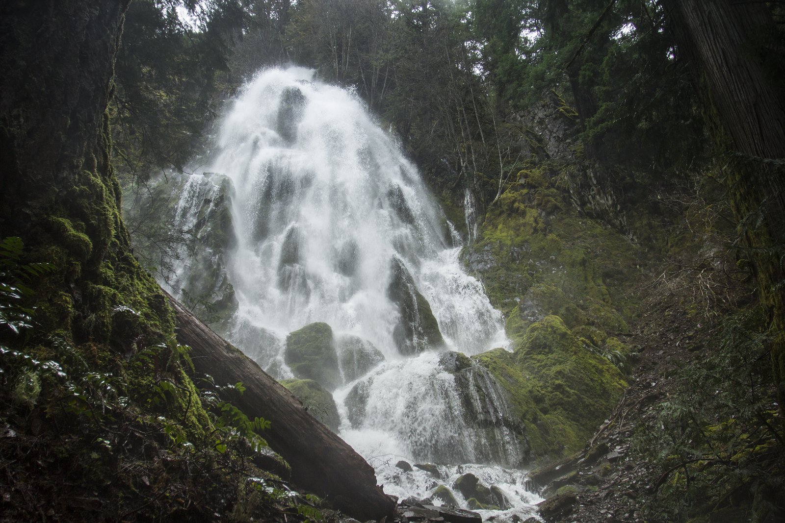
Moonfalls
Oregon • 50 ft
By Armen Suny · Last verified May 2026

Photo Credits (1)
Difficulty
Easy
Trail Length
0.5 miles
Trail Type
Out And Back
Elevation Gain
50 ft
About Moonfalls
Moonfalls is a picturesque waterfall located in the Umpqua National Forest in Oregon. It is surrounded by lush greenery and is part of the Layng Creek Watershed. The waterfall cascades over a basalt cliff, creating a serene and scenic spot for visitors.
The Setting
Moonfalls sits at 3,028 feet within Umpqua National Forest, fed by the Mf Willamette River, in the mountains of Oregon. The falls drop 50 feet.
Height: 50 feet
Nearby Falls Worth Visiting
Pinard Falls (105 ft) lies 1.8 miles to the south. Also nearby: Upper Trestle Creek Falls (60 ft, 6.2 mi).
Trail & Hike Details
The Approach
The easy hike follows Moonfalls (#1423), a 0.5-mile out-and-back trail over natural surface. Expect 50 feet of elevation gain with grades of 12-20%. The trail is highly developed (Class 4).
USFS Trail
MOONFALLS #1423
Trail Class
Highly Developed
Surface
Avg Grade
USFS Segment
0.38 miTrail Description
The trail to Moonfalls is short and easy, making it accessible for most visitors. It winds through a forested area with minimal elevation gain, leading directly to the base of the waterfall. The path is well-maintained but may be muddy after rain.
What to Expect
The falls drop 50 feet. Dogs are welcome.
Accessibility
The trail is short and relatively flat, but the surface may be uneven. Contact the managing agency for accessibility details.
Frequently Asked Questions
🐶 Are Dogs Allowed at Moonfalls?
✅ Dogs are allowed
Are There Any Fees or Permits Required?
🆖 No fees required
🏊 Is There Swimming at Moonfalls?
❌ Swimming is not allowed
When to Visit
Spring and early summer are the best times to visit, as the waterfall flow is strongest due to snowmelt and seasonal rains.
Seasonal Access
The best time to visit is Spring, Summer, and Fall. Winter access may be limited. Check with Umpqua National Forest for seasonal road closures.
Safety Information
Be cautious of slippery rocks near the waterfall. Watch for fallen trees or debris on the trail, especially after storms.
Current Water Conditions
1,020 ft³/s
Current discharge — how much water is flowing
Lower than usual for this time of year
Based on 103 years of record
2.26 ft
Water depth at gauge
60°F
ColdBracing — limit time in water
7-Day Discharge Trend
What does this mean for your visit?
Flow is lower than usual for this time of year. Water temperature is a bracing 60 degrees F, limit your time in the water.
About This Gauge
This gauge is on a nearby waterway and may not reflect exact conditions at the falls.
7-Day Flow Outlook
Based on the USGS gauge MF WILLAMETTE RIVER BLW N FORK, NR OAKRIDGE, OR. (8 km away).
Today
Barely Flowing
1102 cfs
3/10Tomorrow
Low
1096 cfs
4/10Sun
Low
1049 cfs
4/10Mon
Low
1036 cfs
4/10Tue
Low
1003 cfs
4/10Wed
Barely Flowing
900 cfs
5/10Thu
Barely Flowing
910 cfs
3/10Best window: Wed — barely flowing flow, mostly sunny (trip score 5/10).
Best time of year: this gauge typically runs highest from early April to late May, peaking in January.
How we calculate this
This is a transparent outlook, not a precise forecast. We take the waterfall's current flow strength (how it ranks against its historical normal for today, from the nearest USGS stream gauge), carry that ranking forward along the gauge's seasonal curve, and nudge it for forecast rain. Confidence is highest for the next day or two and falls further out. Always check official conditions and your own judgment before visiting — high flows can be dangerous.
Know when to go.
Get a free email alert when waterfalls near Westfir hit peak flow. We only send when conditions are worth the trip — no weekly newsletters, no spam.
Weather Forecast
Location & Access
Getting There
Moonfalls can be accessed via Forest Service roads in the Umpqua National Forest. From Cottage Grove, take Row River Road east, then follow signs for Layng Creek and Forest Road 1790. The trailhead is located near the end of the road.
Get Directions on Google MapsParking
There is a small parking area available at the trailhead, but space may be limited during peak seasons.
Elevation
3,028 feet above sea level
Coordinates
43.735679° N, -122.611180° W
Land Management
Managed by USFS
Visitor Tips & Gear
Visit early in the day to avoid crowds and secure parking. Wear sturdy shoes, as the trail can be slippery after rain. Bring insect repellent during the summer months.
As an Amazon Associate, we earn from qualifying purchases.
For this easy 0.5 miles trail, lightweight trail shoes and a water bottle are usually sufficient. Sun exposure on the trail makes good sun protection a must in summer.

Polarized Sunglasses (Knockaround)
Cuts glare off the water so you actually see the falls — and your photos turn out better too.

Columbia Watertight II Rain Jacket
Packs into its own pocket, seam-sealed, and keeps you dry from spray and surprise rain.

Earth Pak Waterproof Dry Bag
Keeps your phone and gear dry when waterfall mist soaks everything else.

Waterproof Phone Pouch (AiRunTech)
Cheap insurance — take photos right next to the falls without killing your phone.

JOBY GorillaPod Starter Kit
Wraps around railings and rocks for long-exposure waterfall shots — no flat surface needed.

Osprey Daylite Daypack
Light, organized, and just the right size for a day hike — fits water, snacks, and layers.
Where to Stay

Cascade Motel

Oakridge Inn & Suites

Shelter Cove Resort & Marina

Comfort Inn & Suites Creswell
Browse vacation cabins and private rentals nearby
Unique outdoor stays — tents, yurts, and treehouses
Rent a campervan or RV for your waterfall road trip
Some links are affiliate links. We may earn a commission at no extra cost to you.
Nearby Campground
Middle Fork Ranger District (Hwy 58)
4.2 miles away · 0 sites
Middle Fork Ranger District (US Highway 58)Middle Fork Ranger District is the southern part of the forest, bordering the Deschutes and Umpqua National Forests. Accessible from the west on Highway 58 from Eugene, OR, or from the south via Highway 58.Spend some time exploring Waldo Lake, one of the gems of the forest, but don’t forget to get out on some of the great mountain biking, hiking, and horse trails in this area.HikingBackpacking and day hikes can be found all over the district including, F
Book on Recreation.govNearby Hot Springs
Hot springs near Westfir, Oregon
Kitson Hot Springs
Kitson Hot Springs flows at 109°F within Willamette National Forest at 1,664 feet elevation, positioned just 17 meters from For...

Mccredie Springs
McCredie Springs flows at 163°F along Salt Creek in the Willamette National Forest, creating one of western Oregon's most popul...
Wall Creek Warm Springs
Wall Creek Warm Springs flows at 106°F deep within Willamette National Forest at 2,362 feet elevation on the western Cascades s...

Umpqua Hot Springs
Umpqua Hot Springs flows at 117°F from multiple geothermal sources along the North Umpqua River in Lane County, forming cascadi...

Cougar Reservoir Hot Springs
Cougar Reservoir Hot Springs, widely known as Terwilliger Hot Springs, flows at 111 degrees Fahrenheit with roadside access req...
Foley Springs
Foley Springs emerges at 178°F in the Cascade Range of Lane County, making it one of Oregon's hottest thermal features with rec...
Looking for a soak after your hike? Explore more hot springs near Westfir, Oregon on SoakingSprings.
Explore Oregon springsAdditional Information
Nearby Attractions
Nearby attractions include Spirit Falls and Pinard Falls, which are also located in the Umpqua National Forest.
Wildlife
The area is home to a variety of wildlife, including birds, deer, and small mammals. Visitors may also see wildflowers in the spring.
Cities near Moonfalls
Nearby Waterfalls
Writing about Moonfalls? Embed this waterfall on your site for free.