Photo Credits (5)
Difficulty
Moderate
Trail Length
2.4 miles
Trail Type
Out And Back
Elevation Gain
350 ft
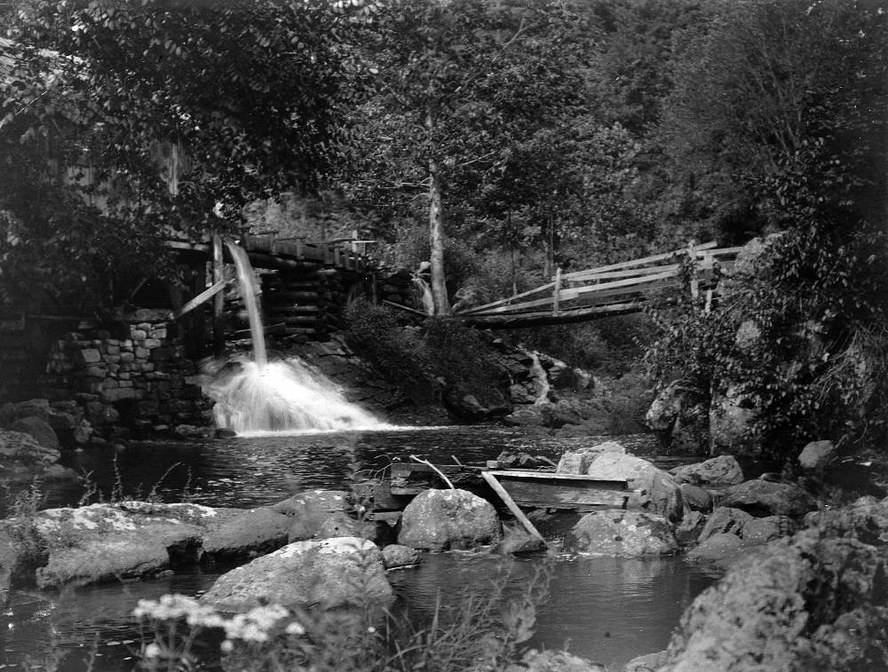
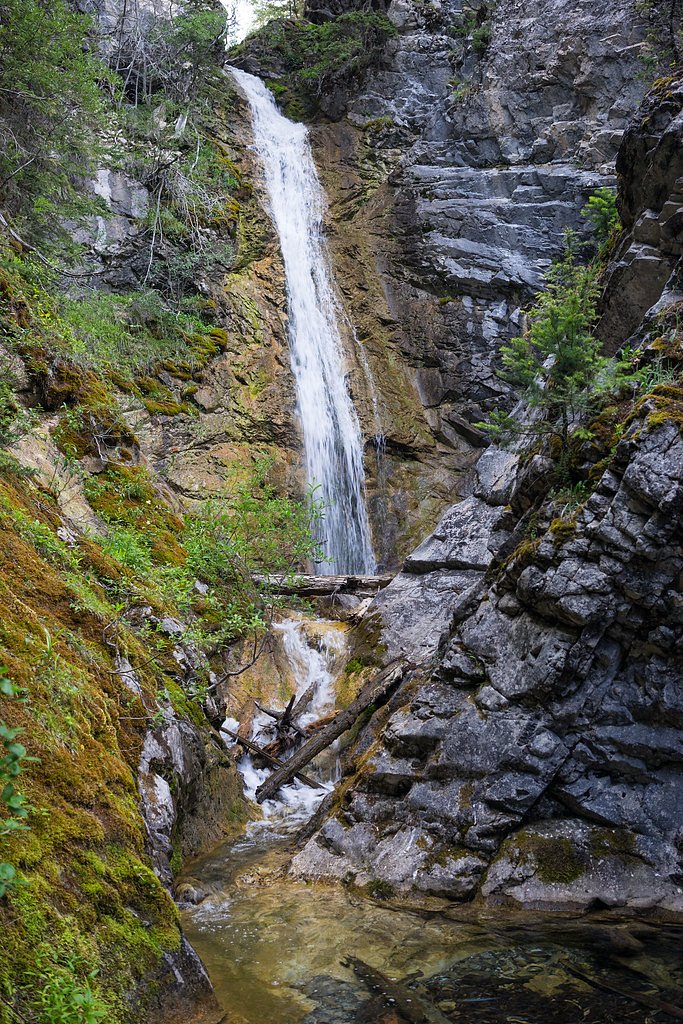
About Mill Falls
Mill Falls is a peaceful, picture-perfect cascade tucked inside the Lewis & Clark National Forest and managed by the U.S. Forest Service. Though modest in size, the falls make a rewarding destination for hikers looking for a quiet nature break amid forested surroundings. The official access follows the USFS HEADQUARTERS CREEK trail (Trail #165), and the short approach and creekside setting make Mill Falls a pleasant spot for photography and relaxing by the water. For anyone planning an overnight stay, Green Gulch Dispersed Camp Campground sits just 1.34 km away, making multi-day exploration of the area convenient. Because the falls and approach are on National Forest land, visitors should follow Leave No Trace practices and any local USFS signage while enjoying the serene setting.
The Setting
Mill Falls sits at 5,741 feet within Lewis & Clark National Forest, fed by the Teton River Bl South Fork, in the high mountains of Montana.
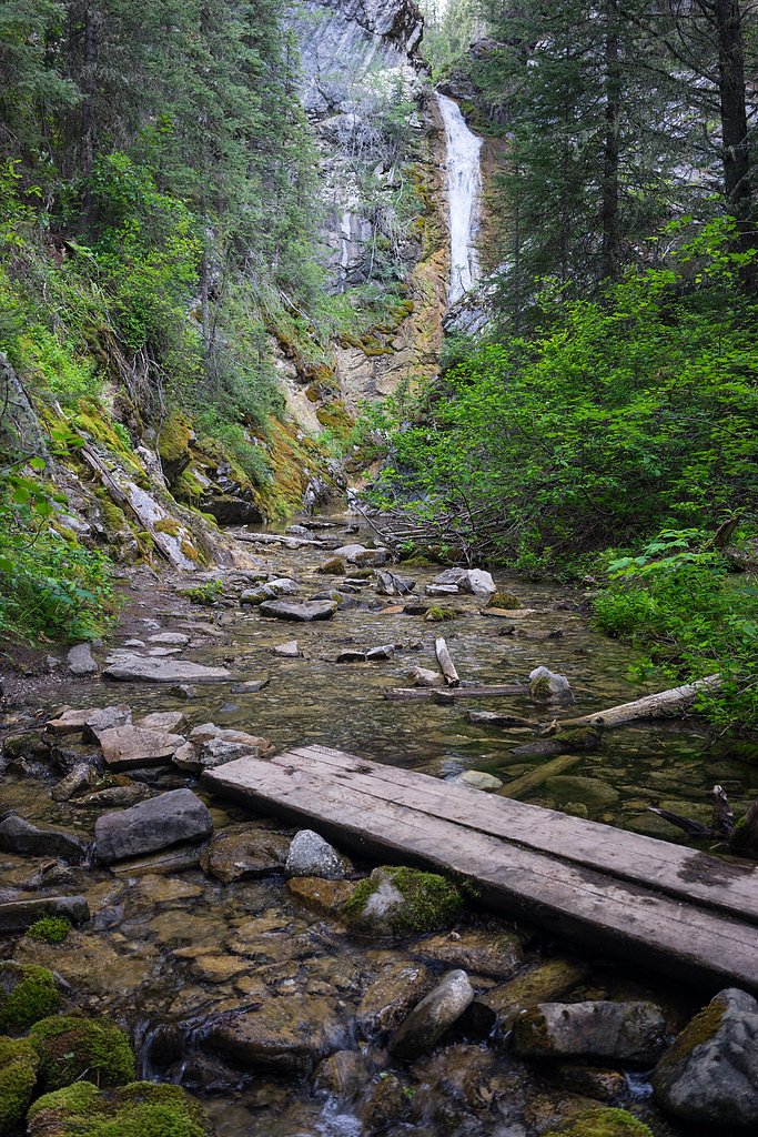
Trail & Hike Details
The Approach
The moderate hike follows Headquarters Creek (#165), a 2.4-mile out-and-back trail over natural surface. Expect 350 feet of elevation gain. The trail is developed (Class 3).
USFS Trail
HEADQUARTERS CREEK #165
Trail Class
Developed
Surface
USFS Segment
0.12 miTrail Description
The designated USFS approach is the HEADQUARTERS CREEK trail (Trail #165). According to Forest Service data the trail segment near the falls is Class 3 with a native-material surface and is mapped at 0.12 GIS miles; the full out-and-back route commonly used to reach Mill Falls is 2.4 miles round trip with about 350 feet of elevation gain and is rated moderate in difficulty. Expect natural footing — roots, soil and rocks — and a route that is short but can feel moderately strenuous due to the elevation change. Trail users should be prepared with sturdy shoes and basic navigation awareness when following the USFS route.
What to Expect
Visitors can expect a peaceful hike through a wooded area leading to a small but charming waterfall. The area may be less crowded compared to more popular waterfalls in Montana.
Accessibility
The trail is not wheelchair accessible. Uneven terrain and elevation changes require steady footing.
Frequently Asked Questions
🐶 Are Dogs Allowed at Mill Falls?
❌ Dogs are not allowed
Are There Any Fees or Permits Required?
🆖 No fees required
🏊 Is There Swimming at Mill Falls?
❌ Swimming is not allowed
When to Visit
Spring and early summer are ideal times to visit, as the waterfall is likely to have the most water flow during these seasons.
Seasonal Access
The best time to visit is Spring, Summer, and Fall. Access roads and trails may close during winter due to snow. Check with Lewis & Clark National Forest for seasonal road closures.
Safety Information
Visitors should be cautious of slippery rocks near the waterfall and watch for uneven trail surfaces. Check weather conditions before visiting.
Current Water Conditions
175 ft³/s
Current discharge — how much water is flowing
About average for this time of year
Based on 36 years of record
4.61 ft
Water depth at gauge
7-Day Discharge Trend
What does this mean for your visit?
Flow is about average for this time of year.
About This Gauge
This gauge is on a nearby waterway and may not reflect exact conditions at the falls.
7-Day Flow Outlook
Based on the USGS gauge Teton River bl South Fork nr Choteau MT (13 km away).
Today
Barely Flowing
189 cfs
3/10Tomorrow
Low
183 cfs
4/10Mon
Low
174 cfs
3/10Tue
Barely Flowing
153 cfs
5/10Wed
Barely Flowing
131 cfs
5/10Thu
Low
143 cfs
3/10Fri
Low
148 cfs
3/10Best window: Tue — barely flowing flow, partly sunny (trip score 5/10).
Best time of year: this gauge typically runs highest from late April to late July, peaking in May.
How we calculate this
This is a transparent outlook, not a precise forecast. We take the waterfall's current flow strength (how it ranks against its historical normal for today, from the nearest USGS stream gauge), carry that ranking forward along the gauge's seasonal curve, and nudge it for forecast rain. Confidence is highest for the next day or two and falls further out. Always check official conditions and your own judgment before visiting — high flows can be dangerous.
Know when to go.
Get a free email alert when waterfalls near Rockport Colony hit peak flow. We only send when conditions are worth the trip — no weekly newsletters, no spam.
Weather Forecast
Location & Access
Getting There
Mill Falls is located in Montana, but specific directions to the site are not widely documented. Visitors are encouraged to consult local maps or guides for precise access details.
Get Directions on Google MapsParking
Parking availability is unclear, but visitors should expect limited parking near the trailhead or access point.
Elevation
5,741 feet above sea level
Coordinates
47.859037° N, -112.775163° W
Land Management
Managed by USFS
Visitor Tips & Gear
Wear sturdy shoes as the trail may have uneven terrain. Bring water and a camera to capture the scenic beauty. Check local conditions before visiting, especially during spring when trails may be muddy.
This trail sits at 5,741 ft above sea level
Elevated TrailUV radiation is roughly 23% stronger at this elevation than at sea level, and the dry air accelerates dehydration. Extra sun protection and fluids go a long way.
As an Amazon Associate, we earn from qualifying purchases.

Coppertone Sport SPF 50 Sunscreen
UV intensity jumps ~4% per 1,000 ft — at this elevation you can burn in half the time.

Sun Bum SPF 30 Lip Balm (3-Pack)
Lips have almost no natural UV protection and burn fast in thin, dry mountain air.

Liquid I.V. Electrolyte Packets
You lose moisture ~2x faster at elevation — electrolytes help you absorb water efficiently.

ROCKNIGHT Polarized UV400 Sunglasses
High-altitude glare off rock and water is intense — UV400 lenses block 99%+ of UVA/UVB.
As an Amazon Associate, we earn from qualifying purchases.
With 2.4 miles and 350 ft of elevation gain, sturdy boots and trekking poles will help on this moderate trail. Sun exposure on the trail makes good sun protection a must in summer.

Polarized Sunglasses (Knockaround)
Cuts glare off the water so you actually see the falls — and your photos turn out better too.

Columbia Watertight II Rain Jacket
Packs into its own pocket, seam-sealed, and keeps you dry from spray and surprise rain.

Earth Pak Waterproof Dry Bag
Keeps your phone and gear dry when waterfall mist soaks everything else.

Waterproof Phone Pouch (AiRunTech)
Cheap insurance — take photos right next to the falls without killing your phone.

Timberland Euro Sprint Mid Waterproof
Trusted waterproof boot with premium leather and grippy rubber sole — reliable on rocky, wet trails.

TrailBuddy Trekking Poles
Lightweight aluminum, cork grips, and flip-locks that actually hold — a best-seller for good reason.
Where to Stay

The Coffey House

Big Sky Motel

Charming Choteau Cottage: Ski & Fish Nearby!

Rustic & Rural Cabin in Dupuyer on Open 14 Acres!
Browse vacation cabins and private rentals nearby
Unique outdoor stays — tents, yurts, and treehouses
Rent a campervan or RV for your waterfall road trip
Some links are affiliate links. We may earn a commission at no extra cost to you.
Nearby Campground
Green Gulch Dispersed Camp Campground
0.8 miles away · 0 sites
Dispersed Campground.Bears may frequent the area; keep all food out of sight in approved containers and remove all food from area after eating. Mandatory food storage is required.
Book on Recreation.govNearby Hot Springs
Hot springs near Rockport Colony, Montana
Looking for a soak after your hike? Explore more hot springs near Rockport Colony, Montana on SoakingSprings.
Explore Montana springsAdditional Information
Nearby Attractions
Other natural attractions in Montana, such as Glacier National Park, may be worth exploring.
Wildlife
The area may feature common Montana wildlife such as deer, birds, and small mammals. Visitors should remain aware of their surroundings.
Cities near Mill Falls
Writing about Mill Falls? Embed this waterfall on your site for free.