Maple Falls
By Armen Suny · Last verified May 2026
Difficulty
Moderate
Trail Length
7.5 miles
Trail Type
Out And Back
Elevation Gain
800 ft
About Maple Falls
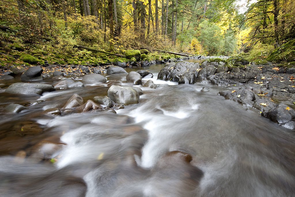
Maple Falls in California is a picturesque waterfall located on public lands within the Klamath National Forest, managed by the U.S. Forest Service. The setting is inviting for day hikers and nature lovers seeking a moderate outing — the route rewards steady effort with a scenic cascade and a sense of remoteness on national forest lands. Most visitors access the falls via the USFS Big Ridge Cutoff (Trail #5526). The full outing is an out-and-back of about 7.5 miles with roughly 800 feet of elevation gain and a moderate difficulty rating. For those planning an overnight stay, the Indian Scotty Group Site is nearby (about 8.29 km away), making it convenient to combine the hike with camping in the national forest.
The Setting
Maple Falls sits at 4,275 feet within Klamath National Forest, in the mountains of California.
Trail & Hike Details
The Approach
The moderate hike follows Big Ridge Cutoff (#5526), a 7.5-mile out-and-back trail over natural surface. Expect 800 feet of elevation gain with grades of 12-20%. The trail is developed (Class 3).
USFS Trail
BIG RIDGE CUTOFF #5526
Trail Class
Developed
Surface
Avg Grade
USFS Segment
0.85 miTrail Description
Access to Maple Falls is along the USFS Big Ridge Cutoff (Trail #5526). That trail segment is recorded as Class 3 with a native material (NAT) surface and a typical grade of 12–20%; the GIS-recorded segment length is 0.85 miles. The overall route to the falls is an out-and-back of approximately 7.5 miles with about 800 feet of elevation gain and is rated moderate. Expect narrow, uneven native-surface tread in places and short rock scrambles on the final approach; wear sturdy footwear and use caution after wet weather.
What to Expect
Dogs are welcome.
Accessibility
The trail is not wheelchair accessible. Uneven terrain and elevation changes require steady footing.
Frequently Asked Questions
🐶 Are Dogs Allowed at Maple Falls?
✅ Dogs are allowed
Are There Any Fees or Permits Required?
🤑 Fee: $8.00
🏊 Is There Swimming at Maple Falls?
❌ Swimming is not allowed
When to Visit
Spring is the best time to visit Maple Falls, as the waterfall is typically at its fullest due to seasonal rains. Summer and fall are also good times, but the flow may be reduced.
Seasonal Access
The best time to visit is Spring, Summer, and Fall. Winter access may be limited. Check with Klamath National Forest for seasonal road closures.
Safety Information
Be cautious of slippery rocks and muddy sections, especially after rain. Poison oak is prevalent, so wear long sleeves and pants if possible. Cell service may be limited in the park, so plan accordingly.
Current Water Conditions
55 ft³/s
Current discharge — how much water is flowing
Much lower than usual for this time of year
Based on 84 years of record
4.15 ft
Water depth at gauge
7-Day Discharge Trend
What does this mean for your visit?
Flow is well below normal for this time of year, so the waterfall may be a trickle.
About This Gauge
This gauge is on a nearby waterway and may not reflect exact conditions at the falls.
7-Day Flow Outlook
Based on the USGS gauge SCOTT R NR FORT JONES CA (14 km away).
Today
Barely Flowing
60 cfs
3/10Tomorrow
Low
62 cfs
4/10Sun
Barely Flowing
54 cfs
5/10Mon
Barely Flowing
49 cfs
5/10Tue
Barely Flowing
46 cfs
5/10Wed
Barely Flowing
42 cfs
5/10Thu
Barely Flowing
40 cfs
5/10Best window: Sun — barely flowing flow, sunny (trip score 5/10).
Best time of year: this gauge typically runs highest from mid March to early June, peaking in May.
How we calculate this
This is a transparent outlook, not a precise forecast. We take the waterfall's current flow strength (how it ranks against its historical normal for today, from the nearest USGS stream gauge), carry that ranking forward along the gauge's seasonal curve, and nudge it for forecast rain. Confidence is highest for the next day or two and falls further out. Always check official conditions and your own judgment before visiting — high flows can be dangerous.
Know when to go.
Get a free email alert when waterfalls near Greenview hit peak flow. We only send when conditions are worth the trip — no weekly newsletters, no spam.
Weather Forecast
Location & Access
Getting There
Maple Falls can be accessed via the Forest of Nisene Marks State Park. The trailhead is located near the park entrance, and visitors typically start from the Porter Family Picnic Area or the nearby parking lot.
Get Directions on Google MapsParking
Parking is available at the Forest of Nisene Marks State Park. A day-use fee of $8 is typically required for parking.
Elevation
4,275 feet above sea level
Coordinates
41.644576° N, -123.180324° W
Land Management
Managed by USFS
Visitor Tips & Gear
Wear sturdy hiking shoes, as the trail can be muddy and slippery, especially after rain. Bring plenty of water and snacks, as the hike can take several hours. Check the weather and trail conditions before heading out.
As an Amazon Associate, we earn from qualifying purchases.
With 7.5 miles and 800 ft of elevation gain, sturdy boots and trekking poles will help on this moderate trail. Sun exposure on the trail makes good sun protection a must in summer.

Polarized Sunglasses (Knockaround)
Cuts glare off the water so you actually see the falls — and your photos turn out better too.

Columbia Watertight II Rain Jacket
Packs into its own pocket, seam-sealed, and keeps you dry from spray and surprise rain.

Earth Pak Waterproof Dry Bag
Keeps your phone and gear dry when waterfall mist soaks everything else.

Waterproof Phone Pouch (AiRunTech)
Cheap insurance — take photos right next to the falls without killing your phone.

Timberland Euro Sprint Mid Waterproof
Trusted waterproof boot with premium leather and grippy rubber sole — reliable on rocky, wet trails.

TrailBuddy Trekking Poles
Lightweight aluminum, cork grips, and flip-locks that actually hold — a best-seller for good reason.
Where to Stay

Browse vacation cabins and private rentals nearby
Unique outdoor stays — tents, yurts, and treehouses
Rent a campervan or RV for your waterfall road trip
Some links are affiliate links. We may earn a commission at no extra cost to you.
Nearby Campground
INDIAN SCOTTY GROUP SITE
5.2 miles away · 1 sites
Overview Indian Scotty Group Site is located next to the Wild and Scenic Scott River in Klamath National Forest. Visitors enjoy swimming, tubing, whitewater boating. and fishing on the river. Several trailheads for the Marble Mountains Wilderness are nearby.Recreation During summer, when flows in the Scott River are low, campers can fish, swim, or go tubing in the river. During the higher flows of spring, the Scott River offers class IV-V whitewater runs through the Scott River canyon. Several Ma
Book on Recreation.govNearby Hot Springs
Hot springs near Greenview, California
Sulphur Springs
Sulphur Springs flows at a impressive 84°F in Siskiyou County's temperate forest, reaching 29.5 degrees above the cool ambient ...
Jackson Hot Springs
Jackson Hot Springs registers 95°F with highly alkaline chemistry, posting pH 9.3 in sodium-dominated waters containing 95 mg/L...
Bogus Soda Springs
Bogus Soda Springs flows at 76°F from Siskiyou County's volcanic landscape at 2,801 feet elevation. The name suggests early ske...
Looking for a soak after your hike? Explore more hot springs near Greenview, California on SoakingSprings.
Explore California springsAdditional Information
Nearby Attractions
The Forest of Nisene Marks State Park offers several other hiking trails, picnic areas, and scenic spots. Nearby attractions include the town of Aptos and the beaches along the Monterey Bay.
Wildlife
The area is home to a variety of wildlife, including deer, squirrels, and numerous bird species. Poison oak is also common, so stay on the trail.
Cities near Maple Falls
Other waterfalls named Maple Falls
3 other waterfalls share this name across the U.S.
Writing about Maple Falls? Embed this waterfall on your site for free.