Magendanz Falls
By Armen Suny · Last verified May 2026
Difficulty
Moderate
Trail Length
2.4 miles
Trail Type
Out And Back
Elevation Gain
350 ft
About Magendanz Falls
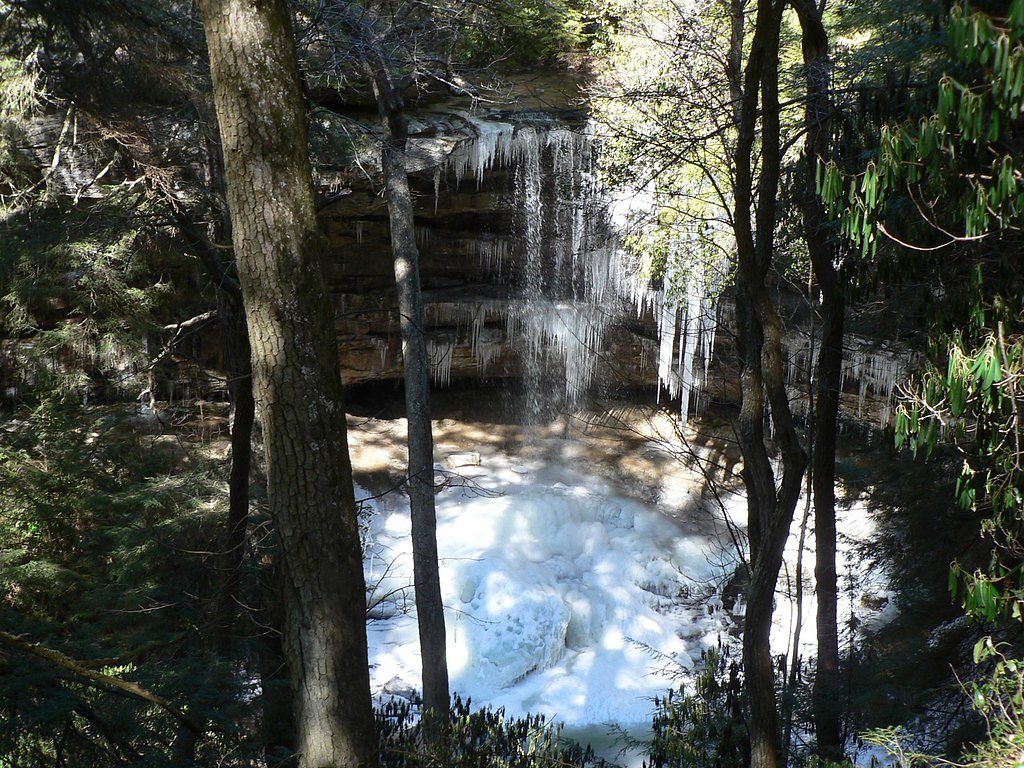
Magendanz Falls is a quiet, lesser-known waterfall tucked into Tennessee’s wooded hills, offering a peaceful reward for hikers looking to escape the crowds. The cascade drops through a canopy of hardwoods and rhododendron, making it an inviting spot for photography, picnics, and a shady rest on warm days. Its tucked-away setting gives the falls a true hidden-gem feel for nature lovers and photographers alike. The falls are reached via a moderate out-and-back hike of 2.4 miles with about 350 feet of elevation gain, so it makes a manageable half-day trip for most moderately fit visitors. There’s no nearby campground within 10 km, so day-use is most common; check local trail reports before you go and bring water and sturdy shoes for the approach.
The Setting
Magendanz Falls sits at 1,512 feet along the Clear Fork, in the hills of Tennessee.
Trail & Hike Details
The Approach
The moderate 2.4-mile out-and-back trail gains 350 feet of elevation on the way to the falls.
Trail Description
Trail type: out-and-back; length: 2.4 miles; elevation gain: ~350 feet; difficulty: moderate. Official USFS trail surface/grade/class information is not available for this route. Hikers should plan on a moderate forest hike—bring sturdy footwear and check local resources or recent trip reports for current conditions before setting out.
What to Expect
Visitors can expect a peaceful and scenic waterfall surrounded by natural forest. The area may be less crowded due to its relative obscurity.
Accessibility
The trail is not wheelchair accessible. Uneven terrain and elevation changes require steady footing.
Frequently Asked Questions
🐶 Are Dogs Allowed at Magendanz Falls?
❌ Dogs are not allowed
Are There Any Fees or Permits Required?
🆖 No fees required
🏊 Is There Swimming at Magendanz Falls?
❌ Swimming is not allowed
When to Visit
Spring and early summer are typically the best times to visit, as water flow is likely to be higher due to seasonal rainfall.
Seasonal Access
The best time to visit is Spring, Summer, and Fall. Winter access may be limited.
Safety Information
Trail conditions may be uneven or slippery, especially after rain. Visitors should exercise caution and avoid visiting during severe weather.
Current Water Conditions
5,860 ft³/s
Current discharge — how much water is flowing
Much higher than usual for this time of year
Based on 84 years of record
9.07 ft
Water depth at gauge
70°F
CoolRefreshing for swimming
7-Day Discharge Trend
What does this mean for your visit?
The water is flowing much higher than usual, expect an impressive display. Water temperature is a refreshing 70 degrees F, good for a quick swim. Expect excellent dissolved oxygen levels. Mineral content is typical.
Water Quality
Dissolved Oxygen
ExcellentSupports aquatic life
Conductance
Dissolved minerals in the water
About This Gauge
This gauge is on a nearby waterway and may not reflect exact conditions at the falls.
7-Day Flow Outlook
Based on the USGS gauge CLEAR FORK NEAR ROBBINS, TN (23 km away).
Today
Roaring
5770 cfs
8/10Tomorrow
Roaring
6359 cfs
8/10Wed
Roaring
8323 cfs
6/10Thu
Roaring
7267 cfs
6/10Fri
Roaring
7552 cfs
6/10Sat
Roaring
7267 cfs
6/10Sun
Roaring
7837 cfs
6/10Best window: Today — roaring flow, areas of fog then mostly sunny (trip score 8/10).
Best time of year: this gauge typically runs highest from late January to early April, peaking in February.
How we calculate this
This is a transparent outlook, not a precise forecast. We take the waterfall's current flow strength (how it ranks against its historical normal for today, from the nearest USGS stream gauge), carry that ranking forward along the gauge's seasonal curve, and nudge it for forecast rain. Confidence is highest for the next day or two and falls further out. Always check official conditions and your own judgment before visiting — high flows can be dangerous.
Know when to go.
Get a free email alert when waterfalls near Allardt hit peak flow. We only send when conditions are worth the trip — no weekly newsletters, no spam.
Weather Forecast
Location & Access
Getting There
Specific directions to Magendanz Falls are not widely documented. Visitors are advised to consult local hiking resources or maps for accurate guidance.
Get Directions on Google MapsParking
Parking availability is unclear. Visitors may need to park along nearby roads or at designated trailheads if available.
Elevation
1,512 feet above sea level
Coordinates
36.363700° N, -84.889596° W
Visitor Tips & Gear
Bring a map or GPS device as the trail may not be well-marked. Wear sturdy footwear and be prepared for varying trail conditions.
As an Amazon Associate, we earn from qualifying purchases.
With 2.4 miles and 350 ft of elevation gain, sturdy boots and trekking poles will help on this moderate trail. Sun exposure on the trail makes good sun protection a must in summer.

Columbia Watertight II Rain Jacket
Packs into its own pocket, seam-sealed, and keeps you dry from spray and surprise rain.

Earth Pak Waterproof Dry Bag
Keeps your phone and gear dry when waterfall mist soaks everything else.

Waterproof Phone Pouch (AiRunTech)
Cheap insurance — take photos right next to the falls without killing your phone.

Timberland Euro Sprint Mid Waterproof
Trusted waterproof boot with premium leather and grippy rubber sole — reliable on rocky, wet trails.

TrailBuddy Trekking Poles
Lightweight aluminum, cork grips, and flip-locks that actually hold — a best-seller for good reason.

Polarized Sunglasses (Knockaround)
Cuts glare off the water so you actually see the falls — and your photos turn out better too.
Where to Stay

Black House Mountain ATV Campground

5 Star with Direct Access to Brimstone Recreation Game Room Comfortable Up to 4 Bedrooms Stylish

Big South Fork Lodge

'Sunset Blue' Family-Friendly Home in Byrdstown!
Browse vacation cabins and private rentals nearby
Unique outdoor stays — tents, yurts, and treehouses
Rent a campervan or RV for your waterfall road trip
Some links are affiliate links. We may earn a commission at no extra cost to you.
Nearby Campground
BANDY CREEK
13.7 miles away · 145 sites
Overview Bandy Creek is a spacious and modern campground, situated in The Big South Fork National River and Recreation Area--a vast and scenic expanse of land that offers visitors countless recreational activities.Recreation Numerous trails snake through the Recreation Area, offering mountain biking, hiking and horseback riding for visitors. A swimming pool, along with on-site volleyball court, playgrounds and ball fields, make Bandy Creek an ideal spot for families. The main river of the Big Sou
Book on Recreation.govAdditional Information
Nearby Attractions
Other waterfalls and hiking trails in Tennessee may be nearby, but specific attractions are not documented.
Wildlife
The area may host typical Tennessee wildlife such as birds, deer, and small mammals. Be cautious of snakes and other potentially hazardous animals.
Cities near Magendanz Falls
Nearby Waterfalls
Writing about Magendanz Falls? Embed this waterfall on your site for free.