Long Hope Falls
By Armen Suny · Last verified May 2026
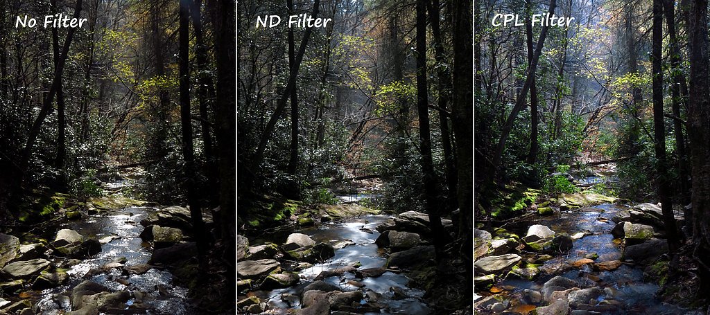
Photo Credits (1)
Difficulty
Moderate
Trail Length
4.5 miles
Trail Type
Out And Back
Elevation Gain
800 ft
About Long Hope Falls
Long Hope Falls sits tucked into the Pisgah National Forest and offers a quiet, rewarding destination for hikers who enjoy a bit of solitude. The route winds through dense hardwoods and follows a shaded creek, culminating at a scenic cascade that feels decidedly off the beaten path — the kind of place adventurous hikers come for peace and uninterrupted forest views. The falls and access sit on U.S. Forest Service land, so expect classic Pisgah forest character and a wooded, creekside approach. The hike to Long Hope Falls is moderate in effort and well suited to daytrippers prepared for uneven terrain. The out-and-back route covers about 4.5 miles with roughly 800 feet of elevation gain, and camping near the trailhead is limited — the nearest developed campground is Iron Mountains, about 25.1 km (15.6 mi) away. Bring sturdy shoes and be ready for slippery rock crossings near the falls to make the most of the visit.
The Setting
Long Hope Falls sits at 3,789 feet along the South Fork New River, in the mountains of North Carolina.
Trail & Hike Details
The Approach
The moderate 4.5-mile out-and-back trail gains 800 feet of elevation on the way to the falls.
Trail Description
This is an out-and-back route of approximately 4.5 miles with about 800 feet of cumulative elevation gain and a moderate difficulty rating. The tread is natural forest trail that becomes narrow and uneven in places, with some steeper sections as you follow the creek. Expect roots, rocks and occasional slick surfaces; the final approach to the waterfall may require careful footwork across wet, slippery rocks. No USFS trail number is provided for this route in the supplied data.
What to Expect
Dogs are welcome.
Accessibility
The trail is not wheelchair accessible. Uneven terrain and elevation changes require steady footing.
Frequently Asked Questions
🐶 Are Dogs Allowed at Long Hope Falls?
✅ Dogs are allowed
Are There Any Fees or Permits Required?
🆖 No fees required
🏊 Is There Swimming at Long Hope Falls?
❌ Swimming is not allowed
When to Visit
Spring and early summer are ideal for visiting Long Hope Falls, as the water flow is typically strongest during these seasons. Fall offers beautiful foliage, while winter may provide a unique view of the waterfall with ice formations.
Seasonal Access
The best time to visit is Spring, Summer, and Fall. Winter access may be limited.
Safety Information
The trail can be slippery, especially after rain. Use caution when crossing rocks near the waterfall. Be aware of potential wildlife encounters and carry bear spray if hiking alone. Always let someone know your plans before heading out.
Current Water Conditions
118 ft³/s
Current discharge — how much water is flowing
Much lower than usual for this time of year
Based on 99 years of record
1.69 ft
Water depth at gauge
7-Day Discharge Trend
What does this mean for your visit?
Flow is well below normal for this time of year, so the waterfall may be a trickle.
About This Gauge
This gauge is on a nearby waterway and may not reflect exact conditions at the falls.
7-Day Flow Outlook
Based on the USGS gauge SOUTH FORK NEW RIVER NEAR JEFFERSON, NC (21 km away).
Today
Moderate
127 cfs
6/10Tomorrow
Moderate
120 cfs
8/10Tue
Moderate
129 cfs
6/10Wed
Strong
130 cfs
7/10Thu
Moderate
121 cfs
9/10Fri
Moderate
144 cfs
6/10Sat
Strong
150 cfs
7/10Best window: Thu — moderate flow, sunny (trip score 9/10).
Best time of year: this gauge typically runs highest from mid February to early May, peaking in April.
How we calculate this
This is a transparent outlook, not a precise forecast. We take the waterfall's current flow strength (how it ranks against its historical normal for today, from the nearest USGS stream gauge), carry that ranking forward along the gauge's seasonal curve, and nudge it for forecast rain. Confidence is highest for the next day or two and falls further out. Always check official conditions and your own judgment before visiting — high flows can be dangerous.
Know when to go.
Get a free email alert when waterfalls near West Jefferson hit peak flow. We only send when conditions are worth the trip — no weekly newsletters, no spam.
Weather Forecast
Location & Access
Getting There
Long Hope Falls is located in the Pisgah National Forest, near the town of Collettsville, North Carolina. Access requires navigating forest service roads, which may be rough and unpaved. A high-clearance vehicle is recommended.
Get Directions on Google MapsParking
Parking is available at a small pull-off area near the trailhead. Space is limited, so arrive early to secure a spot.
Elevation
3,789 feet above sea level
Coordinates
36.382142° N, -81.638989° W
Visitor Tips & Gear
Wear sturdy hiking shoes with good traction, as the trail can be muddy and slippery. Bring plenty of water and snacks, and be prepared for limited cell service in the area. Check weather conditions before your visit, as heavy rain can make the trail more challenging.
As an Amazon Associate, we earn from qualifying purchases.
With 4.5 miles and 800 ft of elevation gain, sturdy boots and trekking poles will help on this moderate trail. Sun exposure on the trail makes good sun protection a must in summer.

Polarized Sunglasses (Knockaround)
Cuts glare off the water so you actually see the falls — and your photos turn out better too.

Columbia Watertight II Rain Jacket
Packs into its own pocket, seam-sealed, and keeps you dry from spray and surprise rain.

Earth Pak Waterproof Dry Bag
Keeps your phone and gear dry when waterfall mist soaks everything else.

Waterproof Phone Pouch (AiRunTech)
Cheap insurance — take photos right next to the falls without killing your phone.

Timberland Euro Sprint Mid Waterproof
Trusted waterproof boot with premium leather and grippy rubber sole — reliable on rocky, wet trails.

TrailBuddy Trekking Poles
Lightweight aluminum, cork grips, and flip-locks that actually hold — a best-seller for good reason.
Where to Stay

Holiday Inn Express West Jefferson by IHG

Rushing Stone Cottage

Country Inn & Suites by Radisson, Boone, NC

Sleep Inn Boone University Area
Browse vacation cabins and private rentals nearby
Unique outdoor stays — tents, yurts, and treehouses
Rent a campervan or RV for your waterfall road trip
Some links are affiliate links. We may earn a commission at no extra cost to you.
Nearby Campground
Iron Mountains
15.6 miles away · 0 sites
Rugged mountain solitude can be experienced throughout this area. Long distance backpacking, trout fishing and the shortest tunnel in the world are a few features you can find here.The Osborne Farm offers a panoramic view of the surrounding mountains from the Appalachian National Scenic Trail (A.T.). From there, take a multi-day backpack trip along the A.T. and Iron Mountain Trail. Try your hand at trout fishing in Beaverdam and Laurel Creeks. Camp at Backbone Rock Recreation Area and explore w
Book on Recreation.govAdditional Information
Nearby Attractions
Other nearby attractions include Wilson Creek, Table Rock Mountain, and Linville Gorge Wilderness.
Wildlife
The area is home to a variety of wildlife, including deer, birds, and occasionally black bears. Be cautious and follow Leave No Trace principles.
Cities near Long Hope Falls
Writing about Long Hope Falls? Embed this waterfall on your site for free.