
Photo Credits (5)
Difficulty
Moderate
Trail Length
2.4 miles
Trail Type
Out And Back
Elevation Gain
350 ft
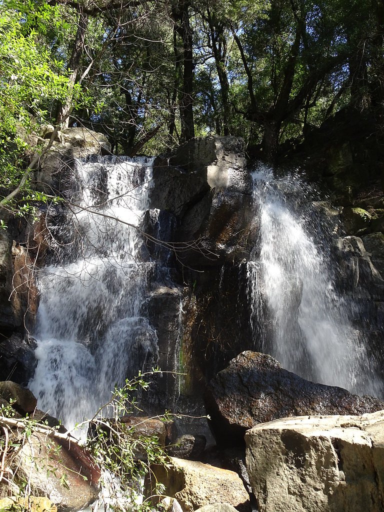
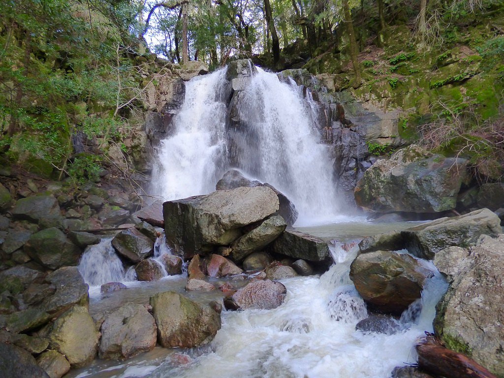
About Linda Falls
Linda Falls is a picturesque cascade tucked into the Napa Valley region of California, offering a peaceful spot for photographers and anyone looking for a quiet woodland escape. The falls sit within the Linda Falls Preserve, a PCON-designated land unit owned and managed by an NGO, and the setting feels intentionally protected and low-key — mature trees frame the water and create a cool, shaded approach. Reaching the viewing area requires a short, moderately paced hike: the out-and-back route covers about 2.4 miles round trip with roughly 350 feet of elevation gain. There are no developed campgrounds immediately adjacent to the preserve; the closest day-use area is Oak Shores Day Use Area, about 18 km away, so plan for a daytime visit and bring water and snacks for the trail.
The Setting
Linda Falls sits at 1,371 feet within Linda Falls Preserve, in the foothills of California.
Trail & Hike Details
The Approach
The moderate 2.4-mile out-and-back trail gains 350 feet of elevation on the way to the falls.
Trail Description
Out-and-back, 2.4 miles round trip with about 350 feet of cumulative elevation gain; rated moderate. The trail follows a well-maintained dirt and forest-floor path through shaded woodlands with occasional moderate grades, making for a steady but accessible hike for most fit walkers. The route leads directly to a clear viewing area at the falls; footing can be natural and uneven in places, so sturdy shoes are recommended.
What to Expect
Dogs are welcome.
Accessibility
The trail is not wheelchair accessible. Uneven terrain and elevation changes require steady footing.
Frequently Asked Questions
🐶 Are Dogs Allowed at Linda Falls?
✅ Dogs are allowed
Are There Any Fees or Permits Required?
🆖 No fees required
🏊 Is There Swimming at Linda Falls?
❌ Swimming is not allowed
When to Visit
Spring is the best time to visit Linda Falls, as the water flow is strongest after the winter rains. Fall is also a good time to visit for cooler weather and fewer crowds.
Seasonal Access
The best time to visit is Spring and Fall. Winter access may be limited.
Safety Information
Be cautious of slippery rocks near the waterfall, especially after rain. Stay on designated trails to avoid damaging the environment and for your safety.
Current Water Conditions
4 ft³/s
Current discharge — how much water is flowing
About average for this time of year
Based on 85 years of record
1.47 ft
Water depth at gauge
7-Day Discharge Trend
What does this mean for your visit?
Flow is about average for this time of year.
About This Gauge
7-Day Flow Outlook
Based on the USGS gauge NAPA R NR ST HELENA CA (5 km away).
Today
Barely Flowing
4 cfs
5/10Tomorrow
Barely Flowing
4 cfs
5/10Sun
Barely Flowing
4 cfs
5/10Mon
Barely Flowing
4 cfs
5/10Tue
Barely Flowing
4 cfs
5/10Wed
Barely Flowing
4 cfs
5/10Thu
Barely Flowing
3 cfs
5/10Best window: Today — barely flowing flow, sunny (trip score 5/10).
Best time of year: this gauge typically runs highest from early January to early April, peaking in February.
How we calculate this
This is a transparent outlook, not a precise forecast. We take the waterfall's current flow strength (how it ranks against its historical normal for today, from the nearest USGS stream gauge), carry that ranking forward along the gauge's seasonal curve, and nudge it for forecast rain. Confidence is highest for the next day or two and falls further out. Always check official conditions and your own judgment before visiting — high flows can be dangerous.
Know when to go.
Get a free email alert when waterfalls near Angwin hit peak flow. We only send when conditions are worth the trip — no weekly newsletters, no spam.
Weather Forecast
Location & Access
Getting There
Linda Falls is located near Angwin, California, and is accessible via the Linda Falls Preserve, managed by the Land Trust of Napa County. The trailhead is located off Howell Mountain Road.
Get Directions on Google MapsParking
Limited parking is available near the trailhead. Visitors are advised to arrive early, especially on weekends, to secure a spot.
Elevation
1,371 feet above sea level
Coordinates
38.555739° N, -122.442292° W
Land Management
Managed by NGO
Visitor Tips & Gear
Wear sturdy shoes as the trail may be muddy after rain. Arrive early to avoid crowds and secure parking. Bring water and snacks, as there are no facilities nearby.
As an Amazon Associate, we earn from qualifying purchases.
With 2.4 miles and 350 ft of elevation gain, sturdy boots and trekking poles will help on this moderate trail.

Columbia Watertight II Rain Jacket
Packs into its own pocket, seam-sealed, and keeps you dry from spray and surprise rain.

Earth Pak Waterproof Dry Bag
Keeps your phone and gear dry when waterfall mist soaks everything else.

Waterproof Phone Pouch (AiRunTech)
Cheap insurance — take photos right next to the falls without killing your phone.

Timberland Euro Sprint Mid Waterproof
Trusted waterproof boot with premium leather and grippy rubber sole — reliable on rocky, wet trails.

TrailBuddy Trekking Poles
Lightweight aluminum, cork grips, and flip-locks that actually hold — a best-seller for good reason.

JOBY GorillaPod Starter Kit
Wraps around railings and rocks for long-exposure waterfall shots — no flat surface needed.
Where to Stay

Vineyard Country Inn

UpValley Inn & Hot Springs, an Ascend Collection Hotel

Le Petit Pali St Helena

The Estate Yountville
Browse vacation cabins and private rentals nearby
Unique outdoor stays — tents, yurts, and treehouses
Rent a campervan or RV for your waterfall road trip
Some links are affiliate links. We may earn a commission at no extra cost to you.
Nearby Campground
OAK SHORES DAY USE AREA (CA)
11.2 miles away · 6 sites
Overview Nestled between Blue Ridge and Cedar Roughs east of Napa Valley, Lake Berryessa provides ample public recreation opportunities. Popular activities on and around the large, yet uncrowded lake include fishing, boating, water skiing, wake boarding, jet skiing, sailing, swimming, kayaking, canoeing, wildlife viewing, hiking, biking and picnicking. The Dufer Point Visitor Center offers year-round interpretive events and exhibits highlighting natural and cultural resources. Lake Berryessa is a
Book on Recreation.govNearby Hot Springs
Hot springs near Angwin, California
White Sulphur Springs (California)
White Sulphur Springs ranks as California's oldest warm mineral springs resort, founded in 1852 in Napa Valley at just 300 feet...
St Helena White Sulphur Spring
St. Helena White Sulphur Spring flows at 97 degrees from roadside in the heart of Napa County wine country at just 300 feet ele...

Aetna Springs
Aetna Springs flows at 91 degrees Fahrenheit near Angwin in Napa County, running 29.8 degrees above ambient at just 814 feet el...

Calistoga Hot Springs
Calistoga Hot Springs surges at an impressive 172°F from the northern Napa Valley at just 353 feet elevation, creating one of t...
Napa Rock Soda Spring, Phillips Sod
Napa Rock Soda Spring (also called Phillips Soda Spring) emerges at 78°F (26°C) in the mountains above Napa Valley with carbona...
Mark West Springs
Mark West Springs discharges at 88°F in Sonoma County wine country, emerging just 23 feet from a public road near Larkfield-Wik...
Looking for a soak after your hike? Explore more hot springs near Angwin, California on SoakingSprings.
Explore California springsAdditional Information
Nearby Attractions
Nearby attractions include the town of St. Helena, wineries in Napa Valley, and other hiking trails in the area such as the Oat Hill Mine Trail.
Wildlife
The area is home to a variety of birds, deer, and other small wildlife. Keep an eye out for native plants and flowers along the trail.
Cities near Linda Falls
Writing about Linda Falls? Embed this waterfall on your site for free.