Limekiln Falls
By Armen Suny · Last verified May 2026
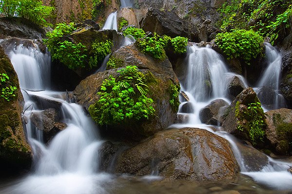
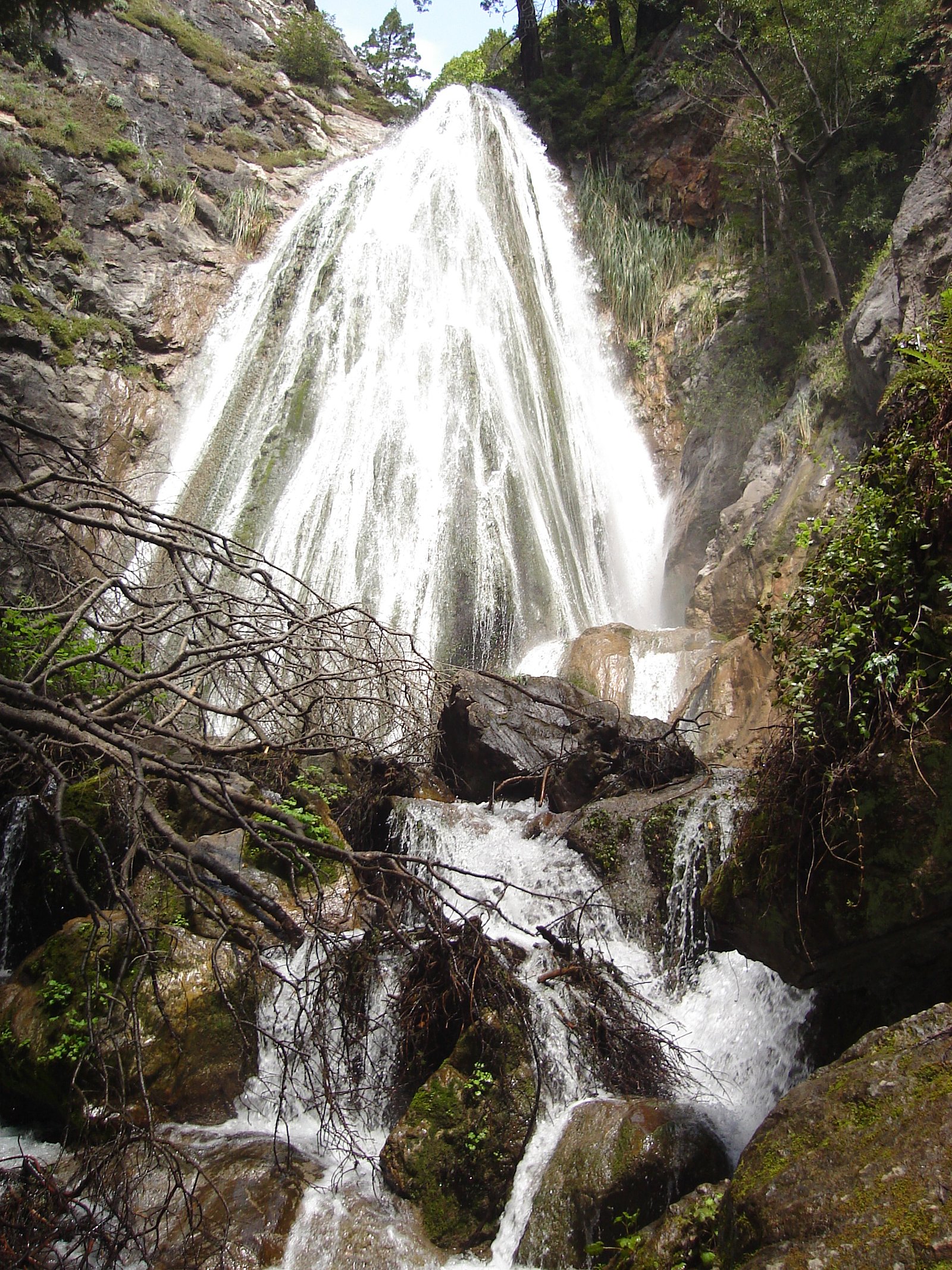
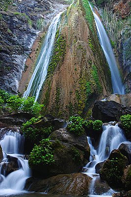
Photo Credits (4)
Difficulty
Moderate
Trail Length
2.4 miles
Trail Type
Out And Back
Elevation Gain
350 ft
About Limekiln Falls
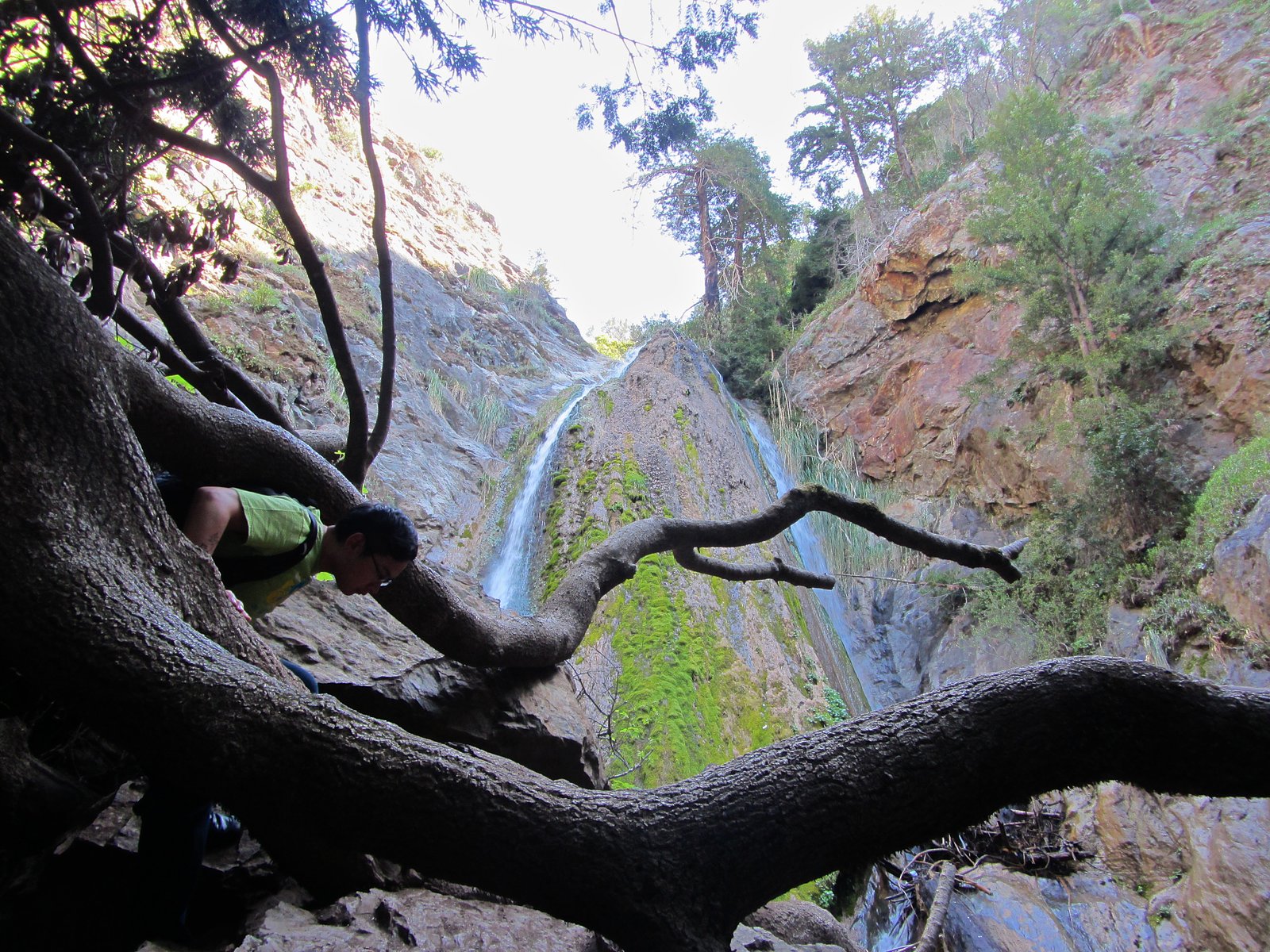
Limekiln Falls sits on the South Branch Moose River southeast of Old Forge, New York, where a scenic cascade drops into a shaded, riverside gorge. The setting is quietly photogenic—mossy rock, flowing water, and a cool forest canopy—making it a favorite short outing for hikers and nature photographers. The approach is a moderate hike of 2.4 miles out-and-back with about 350 feet of elevation gain, so it rewards a bit of effort with close-up views of the falls. Expect a mostly forested route that finishes at the base of the cascade, where the river and rock formations create several good vantage points for photos and quiet contemplation. The trail’s moderate rating means it’s best for hikers who are comfortable with short climbs and uneven footing; bring sturdy shoes and water for a pleasant half-day trip.
The Setting
Limekiln Falls sits at 1,581 feet along the Buck Creek, in the hills of New York.
Trail & Hike Details
The Approach
The moderate 2.4-mile out-and-back trail gains 350 feet of elevation on the way to the falls.
Trail Description
This is a 2.4-mile out-and-back route with approximately 350 feet of elevation gain and a moderate difficulty rating. The trail follows forested terrain along the South Branch Moose River and ends at viewpoints at the base of Limekiln Falls, offering close-up access to the cascade. Hikers should be prepared for typical wooded-trail conditions and moderate climbs; specific surface, grade, and official trail class data were not provided.
What to Expect
Dogs are welcome.
Accessibility
The trail is not wheelchair accessible. Uneven terrain and elevation changes require steady footing.
Frequently Asked Questions
🐶 Are Dogs Allowed at Limekiln Falls?
✅ Dogs are allowed
Are There Any Fees or Permits Required?
🤑 Fee: $0.00
🏊 Is There Swimming at Limekiln Falls?
❌ Swimming is not allowed
When to Visit
Spring and early summer are ideal times to visit Limekiln Falls, as the water flow is typically stronger due to snowmelt and rainfall.
Seasonal Access
The best time to visit is Spring, Summer, and Fall. Winter access may be limited.
Safety Information
Exercise caution near the falls, as rocks can be slippery. Be prepared for changing weather conditions, and carry a map or GPS device as cell service may be limited.
Current Water Conditions
0 ft³/s
Current discharge — how much water is flowing
Much lower than usual for this time of year
Based on 25 years of record
2.23 ft
Water depth at gauge
54°F
ColdBracing — limit time in water
7-Day Discharge Trend
What does this mean for your visit?
Flow is well below normal for this time of year, so the waterfall may be a trickle. Water temperature is a bracing 54 degrees F, limit your time in the water.
About This Gauge
This gauge is on a nearby waterway and may not reflect exact conditions at the falls.
7-Day Flow Outlook
Based on the USGS gauge BUCK CREEK NEAR INLET NY (17 km away).
Today
Barely Flowing
0 cfs
5/10Tomorrow
Barely Flowing
0 cfs
5/10Tue
Low
0 cfs
3/10Wed
Moderate
0 cfs
4/10Thu
Low
0 cfs
6/10Fri
Low
0 cfs
3/10Sat
Moderate
0 cfs
4/10Best window: Thu — low flow, mostly sunny (trip score 6/10).
Best time of year: this gauge typically runs highest from late March to early May, peaking in April.
How we calculate this
This is a transparent outlook, not a precise forecast. We take the waterfall's current flow strength (how it ranks against its historical normal for today, from the nearest USGS stream gauge), carry that ranking forward along the gauge's seasonal curve, and nudge it for forecast rain. Confidence is highest for the next day or two and falls further out. Always check official conditions and your own judgment before visiting — high flows can be dangerous.
Know when to go.
Get a free email alert when waterfalls near Old Forge hit peak flow. We only send when conditions are worth the trip — no weekly newsletters, no spam.
Weather Forecast
Location & Access
Getting There
Limekiln Falls is located near the Limekiln Lake Campground in the Adirondack Park. Visitors can access the falls by following trails from the campground area.
Get Directions on Google MapsParking
Parking is available at the Limekiln Lake Campground, though it may require a day-use fee during peak seasons.
Elevation
1,581 feet above sea level
Coordinates
43.664234° N, -74.904336° W
Visitor Tips & Gear
Wear sturdy shoes as the trail may be muddy or slippery, especially after rain. Bring insect repellent during the summer months to protect against mosquitoes and other bugs.
As an Amazon Associate, we earn from qualifying purchases.
With 2.4 miles and 350 ft of elevation gain, sturdy boots and trekking poles will help on this moderate trail. Sun exposure on the trail makes good sun protection a must in summer.

Polarized Sunglasses (Knockaround)
Cuts glare off the water so you actually see the falls — and your photos turn out better too.

Columbia Watertight II Rain Jacket
Packs into its own pocket, seam-sealed, and keeps you dry from spray and surprise rain.

Earth Pak Waterproof Dry Bag
Keeps your phone and gear dry when waterfall mist soaks everything else.

Waterproof Phone Pouch (AiRunTech)
Cheap insurance — take photos right next to the falls without killing your phone.

Timberland Euro Sprint Mid Waterproof
Trusted waterproof boot with premium leather and grippy rubber sole — reliable on rocky, wet trails.

TrailBuddy Trekking Poles
Lightweight aluminum, cork grips, and flip-locks that actually hold — a best-seller for good reason.
Where to Stay

Adirondack Lodge Old Forge

Great Pines

Conveniently Located Old Forge Condo Near Downtown

HTR Adirondacks
Browse vacation cabins and private rentals nearby
Unique outdoor stays — tents, yurts, and treehouses
Rent a campervan or RV for your waterfall road trip
Some links are affiliate links. We may earn a commission at no extra cost to you.
Additional Information
Nearby Attractions
Limekiln Lake, Adirondack Museum, and other hiking trails in the Adirondack Park.
Wildlife
The area is home to a variety of wildlife, including birds, deer, and small mammals. Visitors should be cautious of black bears, which are occasionally spotted in the region.
Cities near Limekiln Falls
Writing about Limekiln Falls? Embed this waterfall on your site for free.