Lewis Falls
Wyoming • 30 ft
By Armen Suny · Last verified Mar 2026
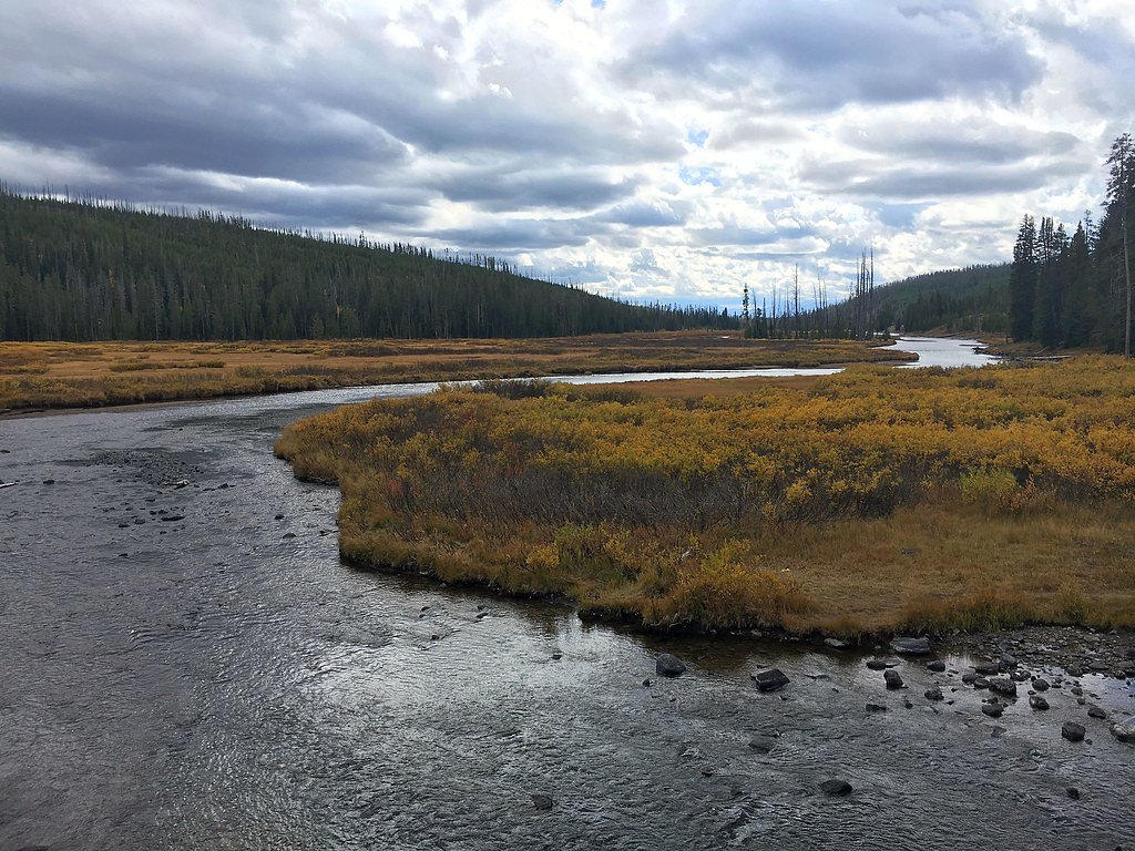
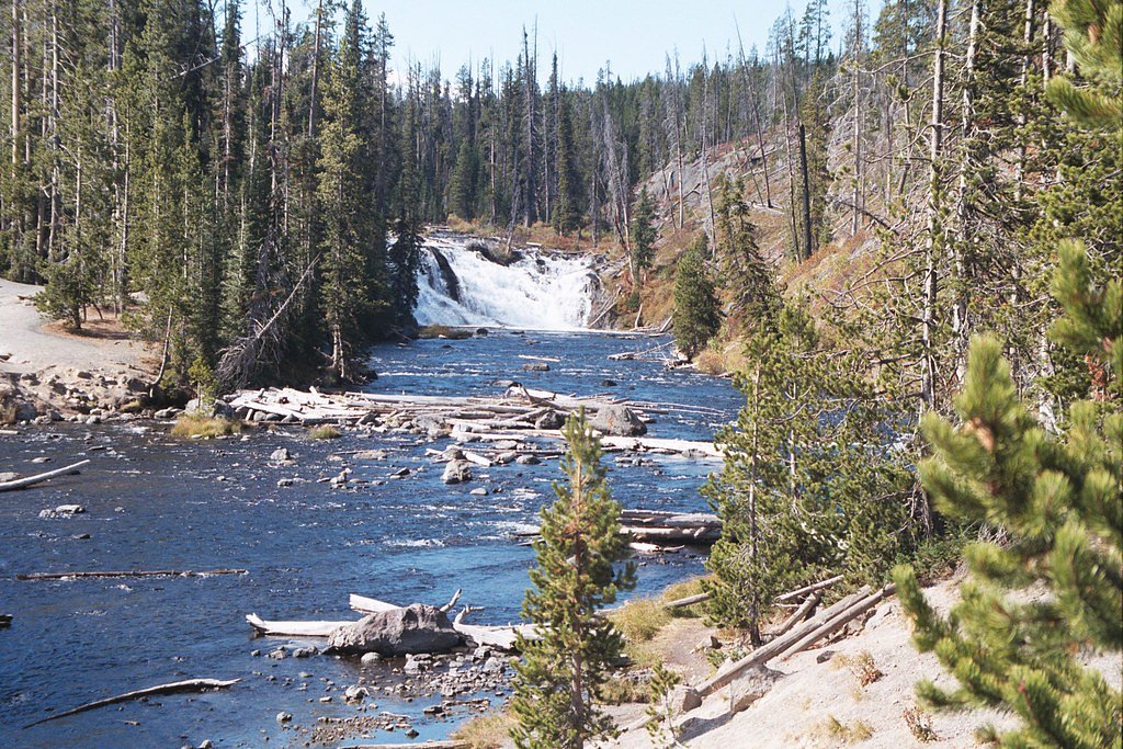
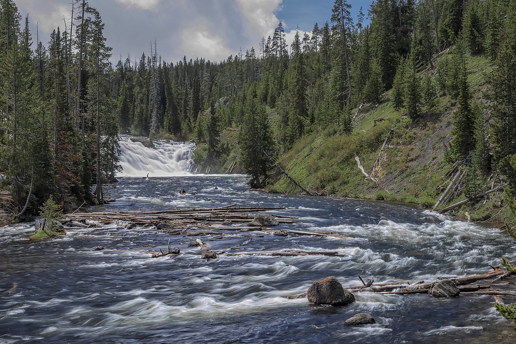
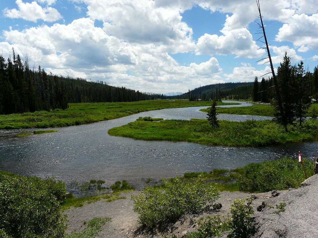

Photo Credits (5)
Difficulty
Drive Up
Trail Length
0.1 miles
Trail Type
Out And Back
Elevation Gain
50 ft
About Lewis Falls
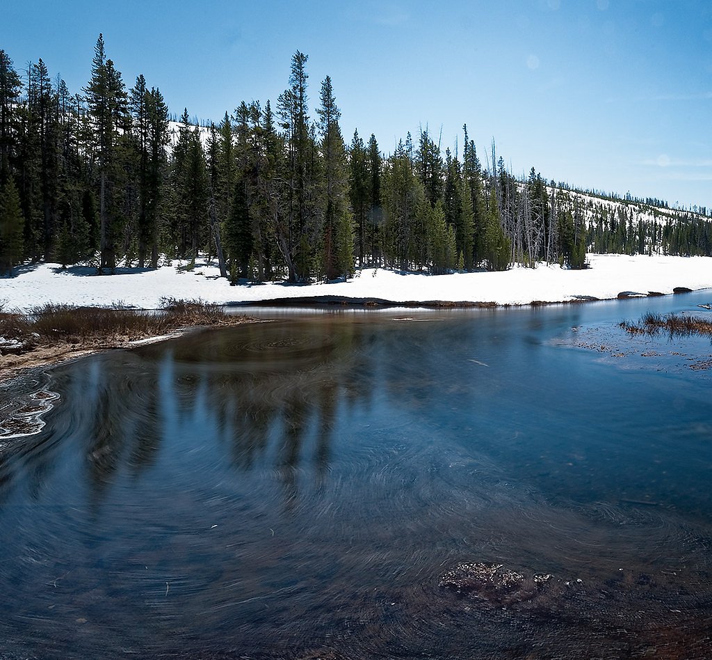
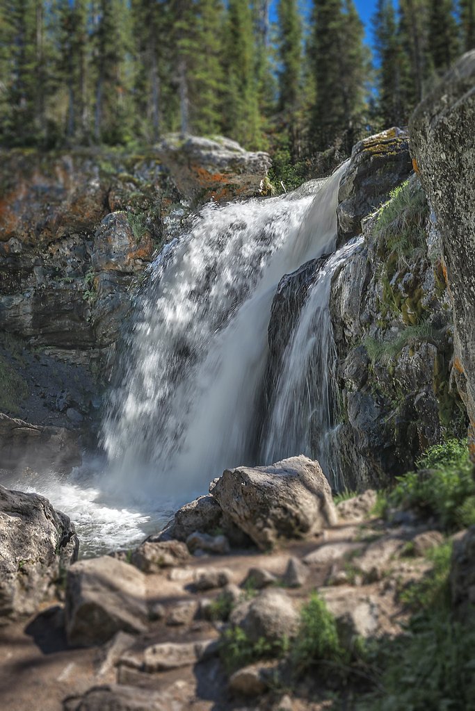
Lewis Falls is a picturesque 30-foot waterfall located in Yellowstone National Park, Wyoming. It is situated along the Lewis River and is easily accessible from the road, making it a popular stop for visitors exploring the park.
The Setting
Lewis Falls sits at 7,726 feet within Yellowstone National Park, fed by the Snake River, in the high mountains of Wyoming. The falls drop 30 feet.
Height: 30 feet
Trail & Hike Details
The Approach
No hiking required. Lewis Falls is accessible by vehicle with a roadside viewing area.
Trail Description
The trail to Lewis Falls is short and easy, making it accessible for most visitors. It is a flat path that leads to a viewing area where you can enjoy the waterfall up close. The trail may be muddy or slippery after rain or snow, so proper footwear is recommended.
What to Expect
The falls drop 30 feet.
Accessibility
This waterfall is viewable from a vehicle-accessible area. No hiking is required.
Frequently Asked Questions
🐶 Are Dogs Allowed at Lewis Falls?
❌ Dogs are not allowed
Are There Any Fees or Permits Required?
🤑 Fee: $35.00
🏊 Is There Swimming at Lewis Falls?
❌ Swimming is not allowed
When to Visit
The best time to visit Lewis Falls is during late spring through early fall when the weather is mild, and the roads are fully accessible. Summer offers the most reliable access, but it can also be crowded.
Seasonal Access
The best time to visit is Spring, Summer, and Fall. Access roads and trails may close during winter due to snow. Check the National Park Service website for current conditions.
Safety Information
Be cautious of slippery rocks and muddy trails near the falls. Wildlife is common in the area, so always stay alert and maintain a safe distance. Follow all park regulations and carry bear spray if hiking in Yellowstone.
Current Water Conditions
1,040 ft³/s
Current discharge — how much water is flowing
About average for this time of year
Based on 42 years of record
3.68 ft
Water depth at gauge
53°F
ColdBracing — limit time in water
7-Day Discharge Trend
What does this mean for your visit?
Flow is about average for this time of year. Water temperature is a bracing 53 degrees F, limit your time in the water.
About This Gauge
This gauge is on a nearby waterway and may not reflect exact conditions at the falls.
7-Day Flow Outlook
Based on the USGS gauge SNAKE RIVER AB JACKSON LAKE AT FLAGG RANCH WY (19 km away).
Today
Low
1030 cfs
6/10Tomorrow
Low
973 cfs
6/10Tue
Low
927 cfs
6/10Wed
Low
895 cfs
6/10Thu
Low
818 cfs
6/10Fri
Low
828 cfs
6/10Sat
Moderate
897 cfs
4/10Best window: Today — low flow, mostly sunny (trip score 6/10).
Best time of year: this gauge typically runs highest from mid April to mid July, peaking in June.
How we calculate this
This is a transparent outlook, not a precise forecast. We take the waterfall's current flow strength (how it ranks against its historical normal for today, from the nearest USGS stream gauge), carry that ranking forward along the gauge's seasonal curve, and nudge it for forecast rain. Confidence is highest for the next day or two and falls further out. Always check official conditions and your own judgment before visiting — high flows can be dangerous.
Know when to go.
Get a free email alert when waterfalls near Kelly hit peak flow. We only send when conditions are worth the trip — no weekly newsletters, no spam.
Weather Forecast
Location & Access
Getting There
Lewis Falls is located along the South Entrance Road in Yellowstone National Park, approximately 10 miles north of the South Entrance. The falls are visible from the road, and there is a small pullout area for parking nearby.
Get Directions on Google MapsParking
There is a small parking area near the falls, but it can fill up quickly during peak seasons. Visitors should plan to arrive early or be prepared to wait for a spot.
Elevation
7,726 feet above sea level
Coordinates
44.267516° N, -110.636846° W
Land Management
Managed by NPS
Visitor Tips & Gear
Arrive early to secure parking, especially during the summer months. Bring a camera to capture the beauty of the falls, and wear sturdy shoes if you plan to explore the trail. Be cautious of slippery surfaces near the water.
This trail sits at 7,726 ft above sea level
Elevated TrailUV radiation is roughly 31% stronger at this elevation than at sea level, and the dry air accelerates dehydration. Extra sun protection and fluids go a long way.
As an Amazon Associate, we earn from qualifying purchases.

Coppertone Sport SPF 50 Sunscreen
UV intensity jumps ~4% per 1,000 ft — at this elevation you can burn in half the time.

Sun Bum SPF 30 Lip Balm (3-Pack)
Lips have almost no natural UV protection and burn fast in thin, dry mountain air.

Liquid I.V. Electrolyte Packets
You lose moisture ~2x faster at elevation — electrolytes help you absorb water efficiently.

ROCKNIGHT Polarized UV400 Sunglasses
High-altitude glare off rock and water is intense — UV400 lenses block 99%+ of UVA/UVB.
As an Amazon Associate, we earn from qualifying purchases.
For this easy 0.1 miles trail, lightweight trail shoes and a water bottle are usually sufficient. Sun exposure on the trail makes good sun protection a must in summer.
America the Beautiful Annual Pass
Covers entrance fees at 2,000+ federal recreation sites — required at most National Parks.

Polarized Sunglasses (Knockaround)
Cuts glare off the water so you actually see the falls — and your photos turn out better too.

Columbia Watertight II Rain Jacket
Packs into its own pocket, seam-sealed, and keeps you dry from spray and surprise rain.

Earth Pak Waterproof Dry Bag
Keeps your phone and gear dry when waterfall mist soaks everything else.

Waterproof Phone Pouch (AiRunTech)
Cheap insurance — take photos right next to the falls without killing your phone.

JOBY GorillaPod Starter Kit
Wraps around railings and rocks for long-exposure waterfall shots — no flat surface needed.

OR Sombriolet Sun Hat
UPF 50+ sun protection with vents so your head doesn't cook on exposed trail sections.
Where to Stay
Browse vacation cabins and private rentals nearby
Unique outdoor stays — tents, yurts, and treehouses
Rent a campervan or RV for your waterfall road trip
Some links are affiliate links. We may earn a commission at no extra cost to you.
Nearby Campground
Headwaters Campground at Flagg Ranch
11.2 miles away · 171 sites
Overview Availability will go live on Recreation.gov on a 6-month rolling basis for RV sites, Tent sites, and Camper Cabins. Located in the John D. Rockefeller, Jr. Memorial Parkway, directly between Grand Teton and Yellowstone National Parks and just minutes from both, Headwaters Campground offers the perfect basecamp for exploration. Situated in a spectacular wooded setting with rolling hills and Teton mountain views, this campground is the perfect place to unwind and unplug, as there is limi
Book on Recreation.govNearby Hot Springs
Hot springs near Kelly, Wyoming
Gas Vent East Of Mary Lake
This geothermal feature lies 6.8 miles from Grand Loop Road at 8,349 feet elevation in Yellowstone's backcountry, accessible on...
Gas Vents Southeast Of Mary Lake
This backcountry thermal feature lies 7.4 miles from Grand Loop Road at 8,500 feet elevation, representing one of Yellowstone's...
Hot Springs
Hot springs flow at 7,535 feet elevation in Yellowstone National Park's interior, situated 8.1 kilometers from Firehole Lake Dr...
Hot Springs East Of Mary Lake
Hot Springs East of Mary Lake emerges at 8,210 feet elevation in Yellowstone's backcountry, located 6.7 miles from Norris-Canyo...
Boundary Creek Hot Springs
Boundary Creek Hot Springs flows at 181°F in one of Yellowstone's most remote backcountry locations, requiring a 3.8-mile hike ...
Jackson Lake Hot Springs
Jackson Lake Hot Springs emerges at 162 degrees Fahrenheit along Jackson Lake's northwestern shore in Grand Teton National Park...
Looking for a soak after your hike? Explore more hot springs near Kelly, Wyoming on SoakingSprings.
Explore Wyoming springsAdditional Information
Nearby Attractions
Nearby attractions include Yellowstone Lake, West Thumb Geyser Basin, and the Grand Canyon of the Yellowstone.
Wildlife
The area around Lewis Falls is home to a variety of wildlife, including elk, bison, and bears. Visitors should maintain a safe distance from all animals and follow park guidelines.
Cities near Lewis Falls
Nearby Waterfalls
Other waterfalls named Lewis Falls
2 other waterfalls share this name across the U.S.
Writing about Lewis Falls? Embed this waterfall on your site for free.