
Photo Credits (2)
Difficulty
Moderate
Trail Length
2.4 miles
Trail Type
Out And Back
Elevation Gain
350 ft
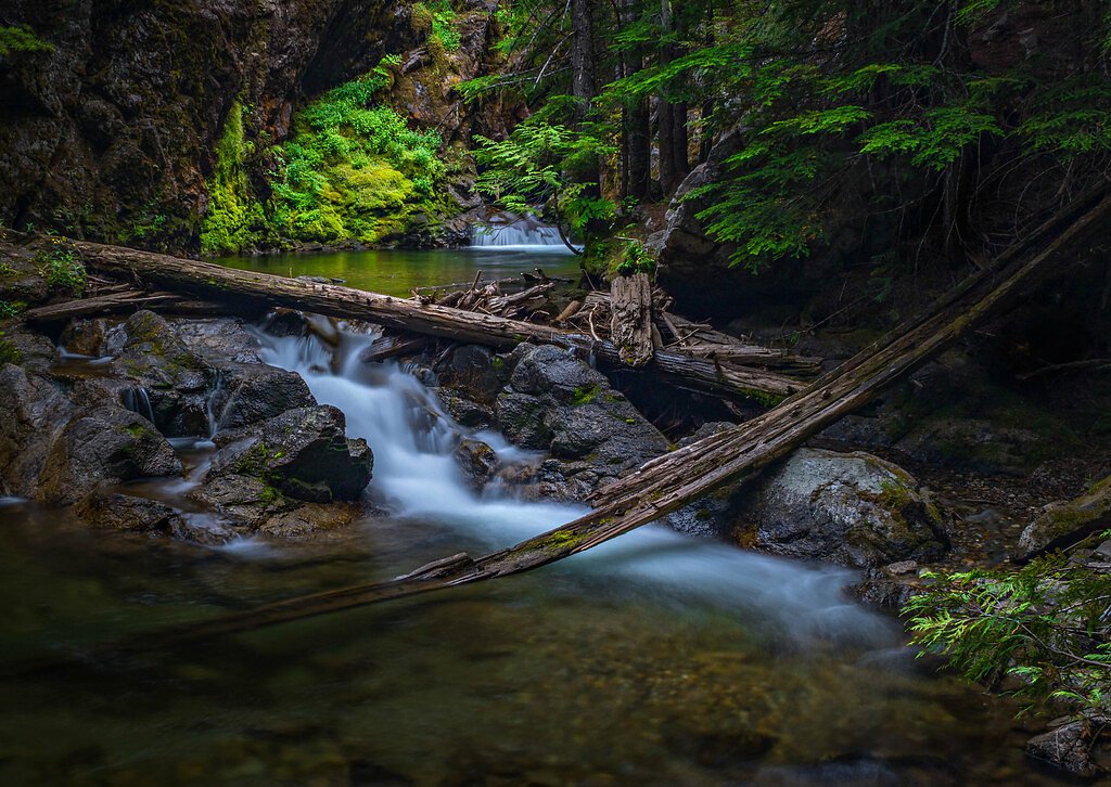
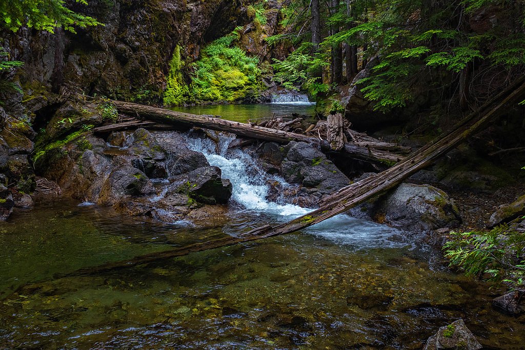
About LaSota Falls
LaSota Falls is a quiet, lesser-known cascade tucked into the old-growth forests of Kaniksu National Forest and managed by the U.S. Forest Service. The cascade is a true hideaway for hikers seeking a peaceful nature stop — mossy banks, towering conifers, and the hush of the forest make it feel worlds away from the trailhead. Specifics about the falls' height aren’t well-documented, which only adds to its off-the-beaten-path appeal. Access to the falls is commonly made using established USFS routes; the approach utilizes the High Rock Mountain Trail (Trail #382). The forest-managed trail includes a short mapped segment (0.26 GIS miles) of native-surface tread, and the full outing to the falls is typically done as a 2.4-mile out-and-back with about 350 feet of elevation gain. Expect native-material tread and some steep pitches — it’s an inviting moderate hike for those comfortable with occasional route-finding in a quiet National Forest setting.
The Setting
LaSota Falls sits at 3,524 feet within Kaniksu National Forest, fed by the Pend Oreille River, in the mountains of Washington.
Trail & Hike Details
The Approach
The moderate hike follows High Rock Mountain (#382), a 2.4-mile out-and-back trail over natural surface. Expect 350 feet of elevation gain with grades of 12-20%. The trail is moderately developed (Class 2).
USFS Trail
HIGH ROCK MOUNTAIN #382
Trail Class
Moderately Developed
Surface
Avg Grade
USFS Segment
0.26 miTrail Description
Out-and-back, 2.4 miles total with approximately 350 feet elevation gain; difficulty: moderate. The formal USFS approach uses High Rock Mountain Trail (Trail #382). The USFS lists that trail segment as Class 2 on a NAT (native material) surface with typical grades of 12–20% and a mapped GIS segment of 0.26 miles; beyond the mapped section, the route can include narrow, native-surface forest tread and occasional unmarked stretches. Plan for uneven footing, short steep pitches, and limited facilities — good footwear and basic navigation skills are recommended.
What to Expect
Visitors can expect a tranquil and scenic waterfall surrounded by dense forest. The area may be less crowded due to its relative obscurity, making it ideal for those seeking solitude.
Accessibility
The trail is not wheelchair accessible. Uneven terrain and elevation changes require steady footing.
Frequently Asked Questions
🐶 Are Dogs Allowed at LaSota Falls?
❌ Dogs are not allowed
Are There Any Fees or Permits Required?
🆖 No fees required
🏊 Is There Swimming at LaSota Falls?
❌ Swimming is not allowed
When to Visit
Spring and early summer may be the best times to visit, as the waterfall is likely to have higher flow due to snowmelt and rainfall.
Seasonal Access
The best time to visit is Spring, Summer, Fall, and Winter. Check with Kaniksu National Forest for seasonal road closures.
Safety Information
The trail may be unmarked or rugged, so visitors should exercise caution. Be prepared for slippery rocks near the waterfall and changing weather conditions. Always inform someone of your plans before heading out.
Current Water Conditions
Based on a USGS gauge 15.9 miles away
37,300 ft³/s
Current discharge — how much water is flowing
About average for this time of year
Based on 73 years of record
92.92 ft
Water depth at gauge
7-Day Discharge Trend
What does this mean for your visit?
Flow is about average for this time of year.
About This Gauge
This gauge is on a regional waterway. Conditions at the falls may differ, especially after local rain.
7-Day Flow Outlook
Based on the USGS gauge PEND OREILLE RIVER BELOW BOX CANYON NEAR IONE, WA (26 km away).
Today
Strong
40284 cfs
8/10Tomorrow
Roaring
40163 cfs
6/10Sun
Roaring
40902 cfs
6/10Mon
Roaring
37799 cfs
6/10Tue
Roaring
37329 cfs
6/10Wed
Roaring
38081 cfs
6/10Thu
Strong
35088 cfs
10/10Best window: Thu — strong flow, partly sunny (trip score 10/10).
Best time of year: this gauge typically runs highest from mid April to mid July, peaking in June.
How we calculate this
This is a transparent outlook, not a precise forecast. We take the waterfall's current flow strength (how it ranks against its historical normal for today, from the nearest USGS stream gauge), carry that ranking forward along the gauge's seasonal curve, and nudge it for forecast rain. Confidence is highest for the next day or two and falls further out. Always check official conditions and your own judgment before visiting — high flows can be dangerous.
Know when to go.
Get a free email alert when waterfalls near Ione hit peak flow. We only send when conditions are worth the trip — no weekly newsletters, no spam.
Weather Forecast
Location & Access
Getting There
The exact directions to LaSota Falls are not widely documented. Visitors may need to rely on local knowledge or GPS coordinates to locate the trailhead. It is recommended to research thoroughly before visiting.
Get Directions on Google MapsParking
Parking availability is unclear. Visitors should prepare for limited or informal parking options near the trailhead.
Elevation
3,524 feet above sea level
Coordinates
48.772145° N, -117.068565° W
Land Management
Managed by USFS
Visitor Tips & Gear
Bring a detailed map or GPS device as the trail may not be well-marked. Wear sturdy footwear and be prepared for uneven terrain. Check weather conditions before visiting, as trails in Washington can become muddy or slippery.
As an Amazon Associate, we earn from qualifying purchases.
With 2.4 miles and 350 ft of elevation gain, sturdy boots and trekking poles will help on this moderate trail. Icy conditions are common in winter — traction cleats are a smart addition.

Columbia Watertight II Rain Jacket
Packs into its own pocket, seam-sealed, and keeps you dry from spray and surprise rain.

Polarized Sunglasses (Knockaround)
Cuts glare off the water so you actually see the falls — and your photos turn out better too.

Earth Pak Waterproof Dry Bag
Keeps your phone and gear dry when waterfall mist soaks everything else.

Waterproof Phone Pouch (AiRunTech)
Cheap insurance — take photos right next to the falls without killing your phone.

Timberland Euro Sprint Mid Waterproof
Trusted waterproof boot with premium leather and grippy rubber sole — reliable on rocky, wet trails.

TrailBuddy Trekking Poles
Lightweight aluminum, cork grips, and flip-locks that actually hold — a best-seller for good reason.
Where to Stay

Beautiful Bungalow and Bunk House, Close to Lake

Unique Nordman Retreat 1 Mi to Priest Lake!

Beautiful Priest Lake Home on the Golf Course

Wilderness West Resort Cabin 4
Browse vacation cabins and private rentals nearby
Unique outdoor stays — tents, yurts, and treehouses
Rent a campervan or RV for your waterfall road trip
Some links are affiliate links. We may earn a commission at no extra cost to you.
Nearby Campground
WEST SULLIVAN
11.7 miles away · 11 sites
Overview West Sullivan Campground is located at the north end of Sullivan Lake and about five miles east of Metaline Falls in northeast Washington. The campground provides a unique environment where campers can enjoy a variety of recreational activities. Recreation The Sullivan Lake Basin provides campers with opportunities for swimming, fishing, boating and hiking. Fishing in this deep mountain lake is most successful from a boat. Common fish species in the lake include burbot (ling cod) and Kok
Book on Recreation.govAdditional Information
Nearby Attractions
Other waterfalls and hiking trails in Washington's forests may be nearby, but specific attractions near LaSota Falls are not documented.
Wildlife
The area may be home to typical Washington wildlife, including birds, deer, and small mammals. Visitors should be cautious of bears and other larger wildlife.
Cities near LaSota Falls
Nearby Waterfalls
Writing about LaSota Falls? Embed this waterfall on your site for free.