Kootenai Falls
By Armen Suny · Last verified Mar 2026
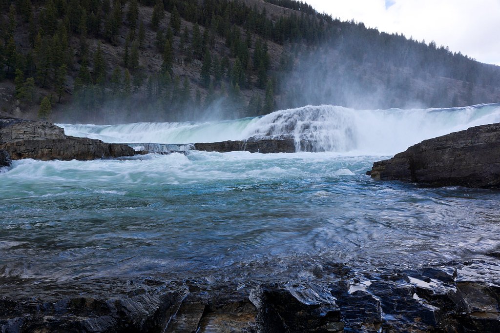
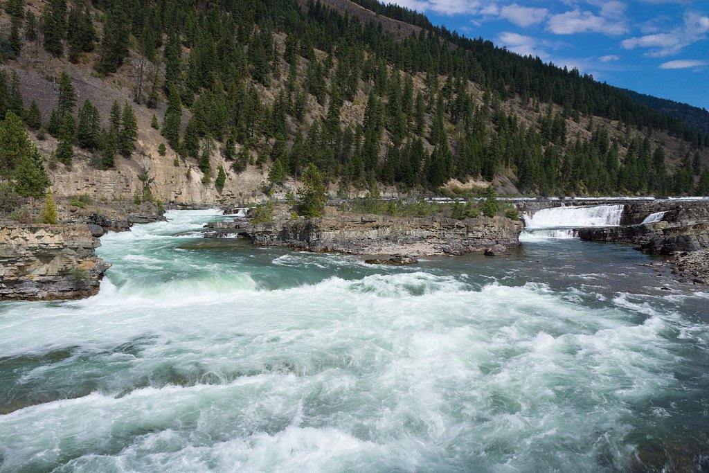
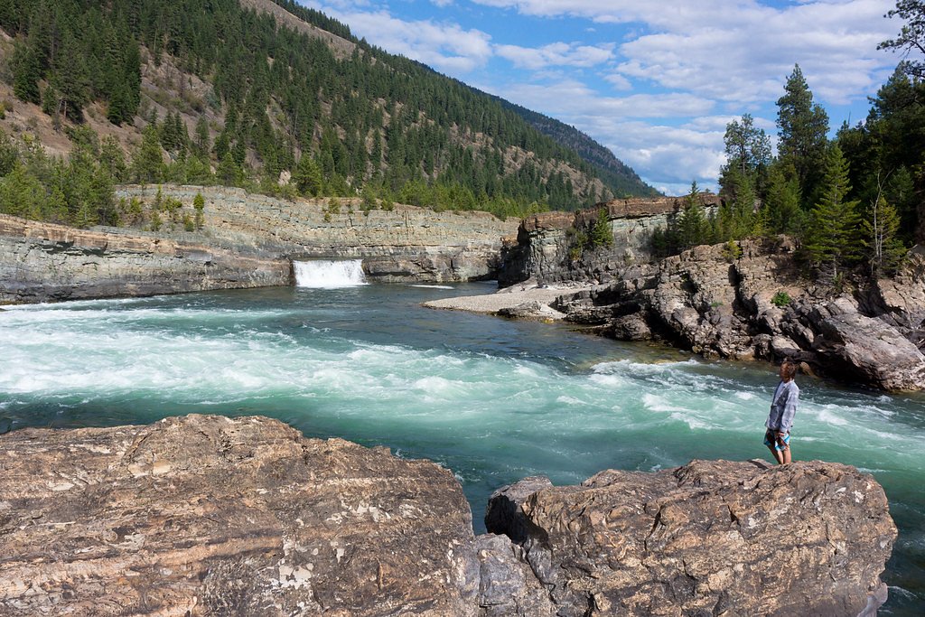
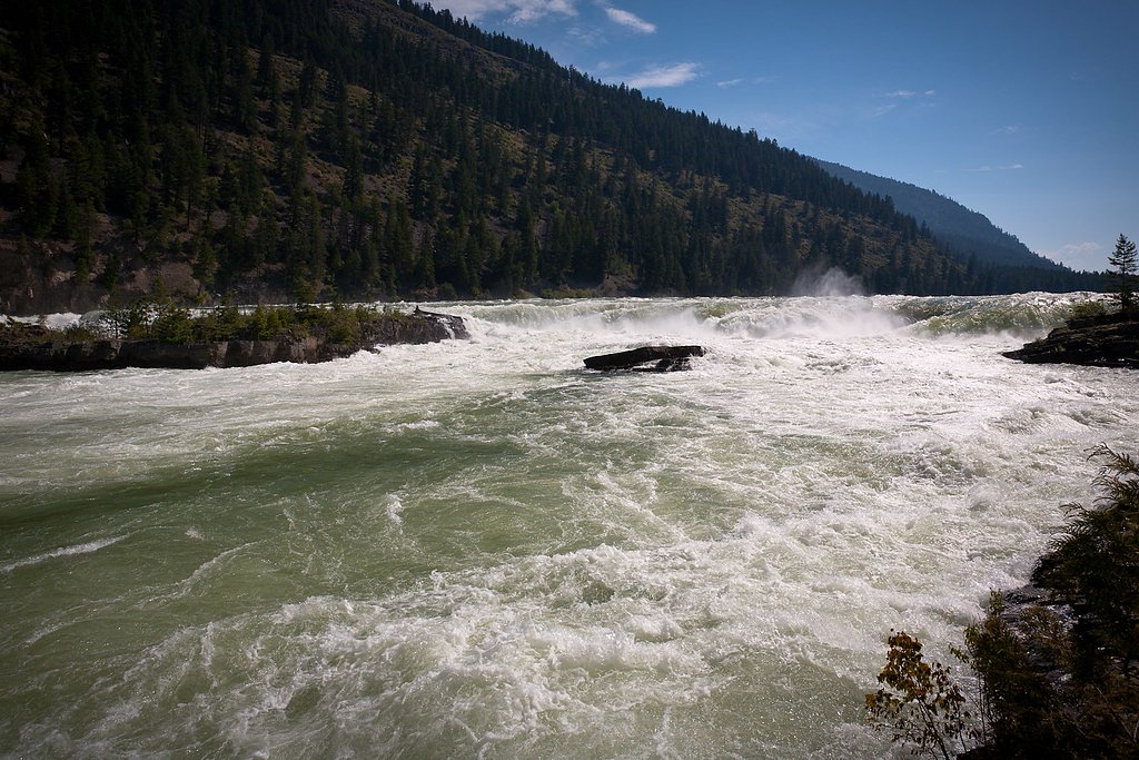

Photo Credits (5)
Difficulty
Easy
Trail Length
0.6 miles
Trail Type
Out And Back
Elevation Gain
100 ft
About Kootenai Falls
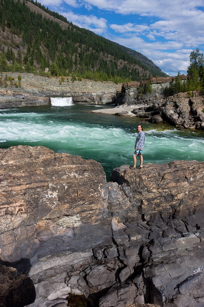
Kootenai Falls roars along the Kootenai River in Lincoln County, just off U.S. Route 2 in northwestern Montana. According to Wikipedia, it is the largest undammed waterfall in the state and one of the largest waterfalls in the United States by flow rate, giving the falls a wide, powerful presence set in a rugged canyon. The site has long been sacred to the local Kootenai Tribe, and its combination of natural power and cultural significance makes it a memorable stop for photographers, anglers, and river lovers alike. In the 2010s the falls grew in popularity largely because of the nearby Kootenai Falls Swinging Bridge downstream; a short foot trail from the highway parking area now provides easy access to multiple viewpoints and to the bridge. The setting feels wild yet accessible, perfect for a quick scenic stop off US‑2 or a relaxed morning outing to take in the cascades and river canyon.
The Setting
Kootenai Falls sits at 1,975 feet along the Yaak River, in the hills of Montana.
Trail & Hike Details
The Approach
The easy 0.6-mile out-and-back trail gains 100 feet of elevation on the way to the falls.
Trail Description
The trail is a short, easy 0.6-mile out-and-back with about 100 feet of elevation gain, suitable for most visitors. Access is from the parking area adjacent to U.S. Route 2; a foot trail leads from the lot to viewpoints at the falls and continues to the Kootenai Falls Swinging Bridge downstream. Expect a brief, mostly gentle climb and short walking distances between viewpoints—an ideal, low-effort hike to experience the falls up close.
What to Expect
Dogs are welcome.
Accessibility
The trail is short and relatively flat, but the surface may be uneven. Contact the managing agency for accessibility details.
Frequently Asked Questions
🐶 Are Dogs Allowed at Kootenai Falls?
✅ Dogs are allowed
Are There Any Fees or Permits Required?
🆖 No fees required
🏊 Is There Swimming at Kootenai Falls?
❌ Swimming is not allowed
When to Visit
Spring and early summer are ideal times to visit, as the water flow is typically at its peak due to snowmelt. Fall offers beautiful foliage, while summer provides warm weather for exploring.
Seasonal Access
The best time to visit is Spring, Summer, and Fall. Winter access may be limited.
Safety Information
Exercise caution near the water, as the currents are extremely strong and the rocks can be slippery. The Swinging Bridge may sway significantly, so hold on to the railings. Be aware of wildlife and carry bear spray if hiking in the area.
Current Water Conditions
407 ft³/s
Current discharge — how much water is flowing
Lower than usual for this time of year
Based on 68 years of record
3.85 ft
Water depth at gauge
7-Day Discharge Trend
What does this mean for your visit?
Flow is lower than usual for this time of year.
About This Gauge
This gauge is on a nearby waterway and may not reflect exact conditions at the falls.
7-Day Flow Outlook
Based on the USGS gauge Yaak River near Troy MT (19 km away).
Today
Barely Flowing
445 cfs
3/10Tomorrow
Low
438 cfs
4/10Mon
Low
422 cfs
4/10Tue
Low
452 cfs
3/10Wed
Low
427 cfs
4/10Thu
Barely Flowing
365 cfs
5/10Fri
Barely Flowing
354 cfs
3/10Best window: Thu — barely flowing flow, mostly sunny (trip score 5/10).
Best time of year: this gauge typically runs highest from late March to late June, peaking in May.
How we calculate this
This is a transparent outlook, not a precise forecast. We take the waterfall's current flow strength (how it ranks against its historical normal for today, from the nearest USGS stream gauge), carry that ranking forward along the gauge's seasonal curve, and nudge it for forecast rain. Confidence is highest for the next day or two and falls further out. Always check official conditions and your own judgment before visiting — high flows can be dangerous.
Know when to go.
Get a free email alert when waterfalls near Troy hit peak flow. We only send when conditions are worth the trip — no weekly newsletters, no spam.
Weather Forecast
Location & Access
Getting There
Kootenai Falls is located off U.S. Highway 2, approximately 7 miles west of Libby, Montana. There is a well-marked parking area with signage directing visitors to the falls.
Get Directions on Google MapsParking
A free parking lot is available near the trailhead, with ample space for cars and small RVs.
Elevation
1,975 feet above sea level
Coordinates
48.455502° N, -115.763224° W
Visitor Tips & Gear
Wear sturdy shoes, as the trail can be uneven in places. Bring water and snacks, especially in warmer months. The Swinging Bridge may sway and can be intimidating for those with a fear of heights. Visit early in the day to avoid crowds, especially during summer.
As an Amazon Associate, we earn from qualifying purchases.
For this easy 0.6 miles trail, lightweight trail shoes and a water bottle are usually sufficient. Sun exposure on the trail makes good sun protection a must in summer.

Polarized Sunglasses (Knockaround)
Cuts glare off the water so you actually see the falls — and your photos turn out better too.

Columbia Watertight II Rain Jacket
Packs into its own pocket, seam-sealed, and keeps you dry from spray and surprise rain.

Earth Pak Waterproof Dry Bag
Keeps your phone and gear dry when waterfall mist soaks everything else.

Waterproof Phone Pouch (AiRunTech)
Cheap insurance — take photos right next to the falls without killing your phone.

JOBY GorillaPod Starter Kit
Wraps around railings and rocks for long-exposure waterfall shots — no flat surface needed.

Osprey Daylite Daypack
Light, organized, and just the right size for a day hike — fits water, snacks, and layers.
Where to Stay

Sandman Motel

Dodge Peak Lodge

Evergreen Motel

Charming Old Farmhouse in Libby: Pets Welcome!
Browse vacation cabins and private rentals nearby
Unique outdoor stays — tents, yurts, and treehouses
Rent a campervan or RV for your waterfall road trip
Some links are affiliate links. We may earn a commission at no extra cost to you.
Nearby Campground
YAAK MTN. LOOKOUT RENTAL
10.2 miles away · 1 sites
Overview Yaak Mountain Lookout rests atop its namesake peak at an elevation of 4,977 feet within the Rocky Mountains in the Kootenai National Forest. The lookout tower has been used as an observation point for spotting forest fires since 1958. The lookout is typically open from mid-June through late September. Access is available via primitive roads, and high clearance vehicles are recommended. This rustic retreat offers a few amenities, but guests will need to bring most of their own gear and su
Book on Recreation.govAdditional Information
Nearby Attractions
Nearby attractions include the town of Libby, Ross Creek Cedars Scenic Area, and Cabinet Mountains Wilderness.
Wildlife
The area is home to a variety of wildlife, including deer, birds, and occasionally bears. Visitors should exercise caution and follow wildlife safety guidelines.
Cities near Kootenai Falls
Writing about Kootenai Falls? Embed this waterfall on your site for free.