Koosah Falls
Oregon • 70 ft
By Armen Suny · Last verified Mar 2026
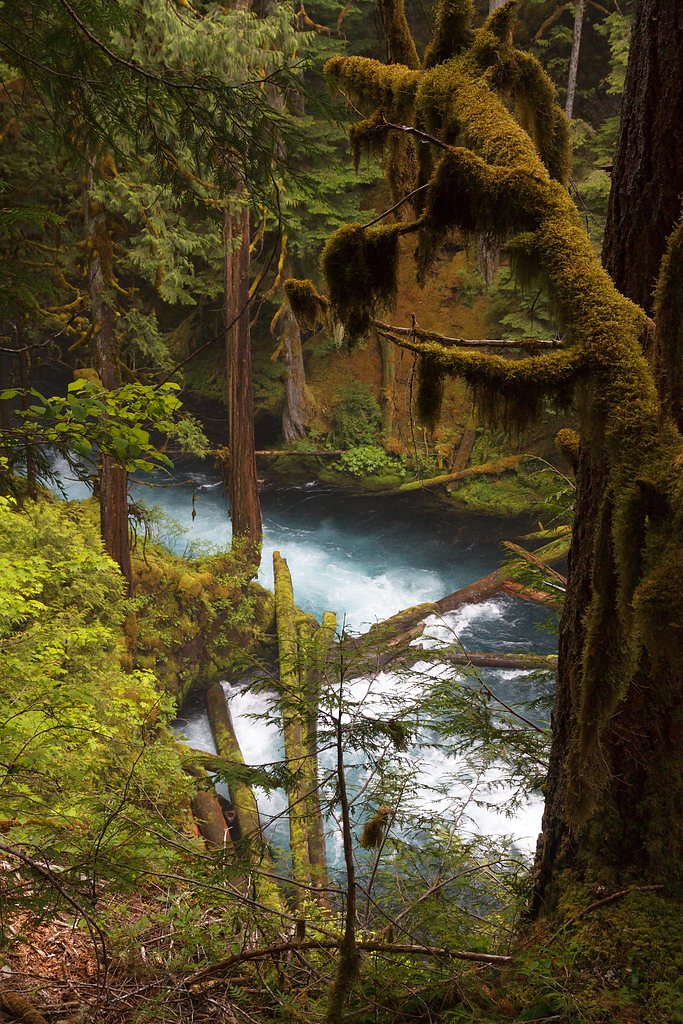
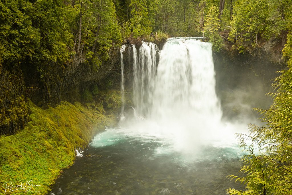
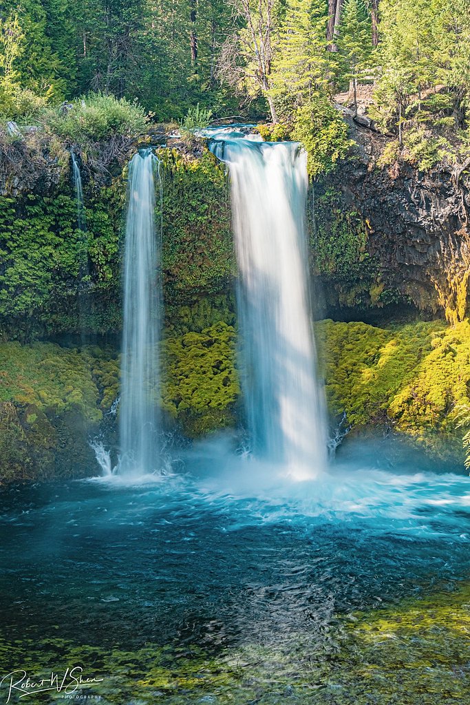
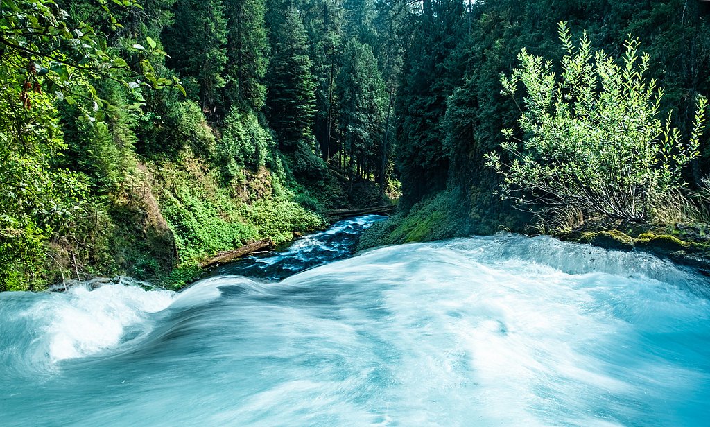

Photo Credits (5)
Difficulty
Easy
Trail Length
2.6 miles
Trail Type
Loop
Elevation Gain
200 ft
About Koosah Falls
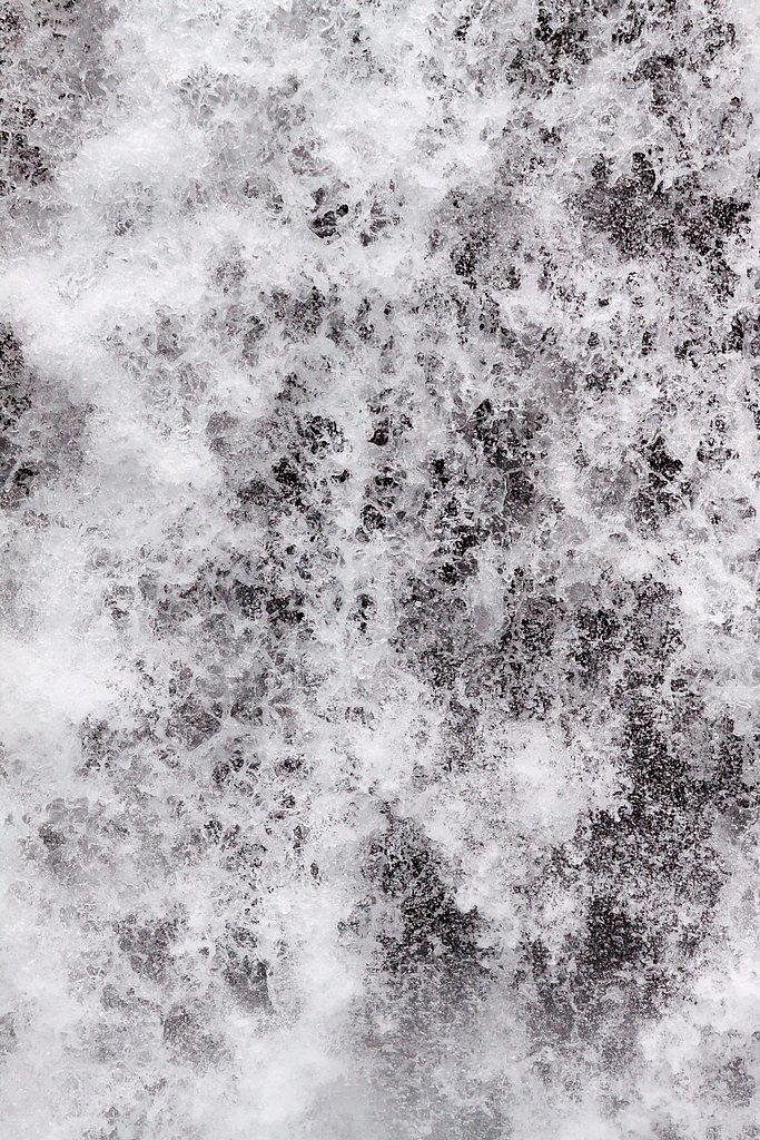
Koosah Falls (also called Middle Falls) tumbles along the McKenzie River in the heart of the Willamette National Forest in Linn County, Oregon. The second of the three major McKenzie River waterfalls, Koosah sends a dramatic main drop of about 64 feet (roughly 20 m) into a deep pool and is often cited as about 70 feet from rim to plunge. The falls sit just south of Santiam Pass and roughly 0.5 miles downstream from Sahalie Falls, framed by lush Cascade forest and volcanic rock that make it a favorite stop for photographers and day hikers alike. The site and trail access are managed by the U.S. Forest Service. A short USFS spur (WATERFALLS, Trail #3503) leads to the primary viewpoints, and many visitors link Koosah with Sahalie for a popular loop. The combined route is about 2.6 miles with roughly 200 feet of elevation gain and is generally rated easy, offering an accessible outing through classic McKenzie River scenery in the Willamette National Forest.
The Setting
Koosah Falls sits at 2,657 feet within Willamette National Forest, fed by the Mckenzie River, in the hills of Oregon. The falls drop 70 feet.
Height: 70 feet
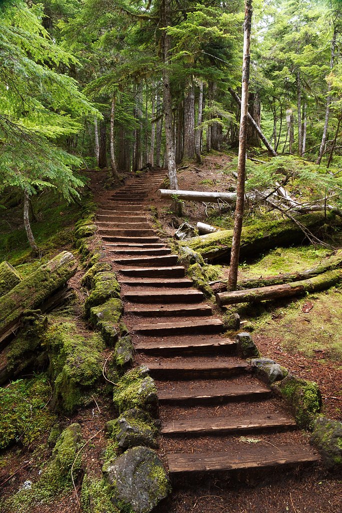
Trail & Hike Details
The Approach
The easy hike follows Waterfalls (#3503), a 2.6-mile loop trail over natural surface. Expect 200 feet of elevation gain with grades of 12-20%. The trail is developed (Class 3).
USFS Trail
WATERFALLS #3503
Trail Class
Developed
Surface
Avg Grade
USFS Segment
0.28 miTrail Description
USFS WATERFALLS (Trail #3503) is a short 0.28-mile spur of native-material tread (Class 3) with typical grades of 12–20% that brings you to the main Koosah Falls viewpoint. The broader McKenzie River route forms a roughly 2.6-mile loop connecting Sahalie and Koosah with about 200 feet of elevation gain; the loop is generally rated easy and provides frequent river and falls views along mostly natural-surface trail.
What to Expect
The falls drop 70 feet. Dogs are welcome.
Accessibility
The trail is not wheelchair accessible. Uneven terrain and elevation changes require steady footing.
Frequently Asked Questions
🐶 Are Dogs Allowed at Koosah Falls?
✅ Dogs are allowed
Are There Any Fees or Permits Required?
🤑 Fee: $5.00
🏊 Is There Swimming at Koosah Falls?
❌ Swimming is not allowed
When to Visit
Spring and early summer are ideal for visiting Koosah Falls, as the water flow is at its peak due to snowmelt. Fall offers beautiful foliage, while winter may provide a quieter experience if the trail is accessible.
Seasonal Access
The best time to visit is Spring, Summer, and Fall. Winter access may be limited. Check with Willamette National Forest for seasonal road closures.
Safety Information
Stay on designated trails and avoid getting too close to the edge of the falls. The rocks can be slippery, and the currents are very strong. Be cautious during wet or icy conditions.
Current Water Conditions
202 ft³/s
Current discharge — how much water is flowing
Much lower than usual for this time of year
Based on 81 years of record
1.37 ft
Water depth at gauge
57°F
ColdBracing — limit time in water
7-Day Discharge Trend
What does this mean for your visit?
Flow is well below normal for this time of year, so the waterfall may be a trickle. Water temperature is a bracing 57 degrees F, limit your time in the water. Mineral content is typical.
Water Quality
Conductance
Dissolved minerals in the water
About This Gauge
7-Day Flow Outlook
Based on the USGS gauge MCKENZIE RIVER AT OUTLET OF CLEAR LAKE, OR (2 km away).
Today
Barely Flowing
202 cfs
5/10Tomorrow
Barely Flowing
201 cfs
5/10Sat
Barely Flowing
216 cfs
3/10Sun
Low
234 cfs
3/10Mon
Low
226 cfs
4/10Tue
Barely Flowing
202 cfs
5/10Wed
Barely Flowing
193 cfs
5/10Best window: Today — barely flowing flow, sunny (trip score 5/10).
Best time of year: this gauge typically runs highest from late March to mid June, peaking in May.
How we calculate this
This is a transparent outlook, not a precise forecast. We take the waterfall's current flow strength (how it ranks against its historical normal for today, from the nearest USGS stream gauge), carry that ranking forward along the gauge's seasonal curve, and nudge it for forecast rain. Confidence is highest for the next day or two and falls further out. Always check official conditions and your own judgment before visiting — high flows can be dangerous.
Know when to go.
Get a free email alert when waterfalls near Black Butte Ranch hit peak flow. We only send when conditions are worth the trip — no weekly newsletters, no spam.
Weather Forecast
Location & Access
Getting There
Koosah Falls is located off Highway 126 in the Willamette National Forest, approximately 55 miles east of Eugene, Oregon. The falls are accessible via a short drive from the parking area near Carmen Reservoir.
Get Directions on Google MapsParking
There is a designated parking area near the trailhead, shared with Sahalie Falls. Parking can fill up quickly during peak seasons, so arriving early is recommended.
Elevation
2,657 feet above sea level
Coordinates
44.344010° N, -122.000617° W
Land Management
Managed by USFS
Visitor Tips & Gear
Wear sturdy shoes as the trail can be muddy, especially after rain. Bring a camera to capture the beautiful scenery. Arrive early to secure parking, especially during weekends and holidays.
As an Amazon Associate, we earn from qualifying purchases.
This easy 2.6 miles hike is straightforward — comfortable trail shoes and plenty of water should do. Sun exposure on the trail makes good sun protection a must in summer.

Polarized Sunglasses (Knockaround)
Cuts glare off the water so you actually see the falls — and your photos turn out better too.

Columbia Watertight II Rain Jacket
Packs into its own pocket, seam-sealed, and keeps you dry from spray and surprise rain.

Earth Pak Waterproof Dry Bag
Keeps your phone and gear dry when waterfall mist soaks everything else.

Waterproof Phone Pouch (AiRunTech)
Cheap insurance — take photos right next to the falls without killing your phone.

JOBY GorillaPod Starter Kit
Wraps around railings and rocks for long-exposure waterfall shots — no flat surface needed.

Osprey Daylite Daypack
Light, organized, and just the right size for a day hike — fits water, snacks, and layers.
Where to Stay

Dog-friendly house with pool hot tub fitness room fireplace grill & deck

The Suttle Lodge & Boathouse

Big Meadow View

Relax and Reconnect - Your Cozy Family Retreat in Sisters OR
Browse vacation cabins and private rentals nearby
Unique outdoor stays — tents, yurts, and treehouses
Rent a campervan or RV for your waterfall road trip
Some links are affiliate links. We may earn a commission at no extra cost to you.
Nearby Campground
Alder Springs Campground
12.3 miles away · 0 sites
This small, rustic site is right on the side of the historic McKenzie Pass Highway. Surrounded by towering Douglas fir trees, this is a perfect spot to be on a warm day.Access to Linton Lake Trailhead in the Three Sisters Wilderness is immediately across the highway from the campground.
Book on Recreation.govNearby Hot Springs
Hot springs near Black Butte Ranch, Oregon

Bigelow Hot Springs
Bigelow Hot Springs, also called Deer Creek Hot Springs, emerges at 142°F just 400 feet from Deer Creek Road in the Willamette ...
Belknap Springs
Belknap Springs flows at 160°F along the McKenzie River in the Cascade Range, emerging just 510 feet from North Belknap Springs...
Foley Springs
Foley Springs emerges at 178°F in the Cascade Range of Lane County, making it one of Oregon's hottest thermal features with rec...

Breitenbush Hot Springs
Breitenbush Hot Springs emerges at 198°F along the Breitenbush River, ranking as one of Oregon's hottest thermal features with ...

Cougar Reservoir Hot Springs
Cougar Reservoir Hot Springs, widely known as Terwilliger Hot Springs, flows at 111 degrees Fahrenheit with roadside access req...

Austin Hot Springs
Austin Hot Springs discharges at 186°F along the Clackamas River at 1,680 feet elevation, emerging just 310 feet from Clackamas...
Looking for a soak after your hike? Explore more hot springs near Black Butte Ranch, Oregon on SoakingSprings.
Explore Oregon springsAdditional Information
Nearby Attractions
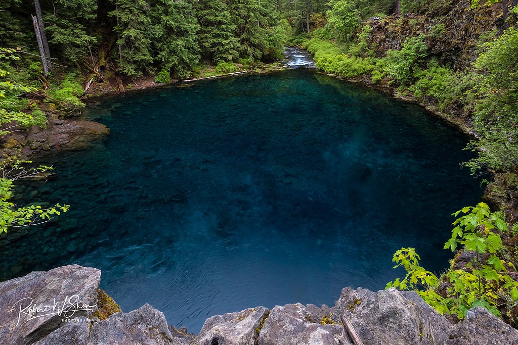
Sahalie Falls, Clear Lake, Tamolitch Blue Pool, McKenzie River Trail
Wildlife
The area is home to deer, squirrels, and a variety of bird species. Keep an eye out for wildlife along the trail.
Cities near Koosah Falls
Nearby Waterfalls
Writing about Koosah Falls? Embed this waterfall on your site for free.