Jump Creek Falls
Idaho • 60 ft
By Armen Suny · Last verified Mar 2026
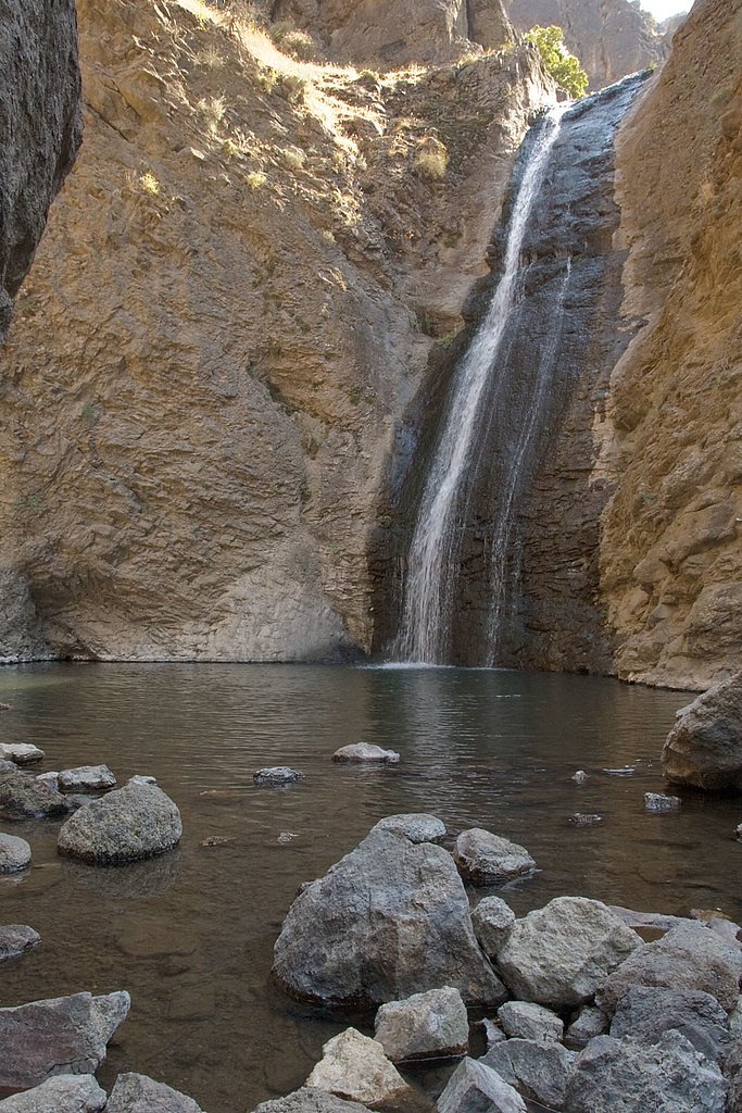
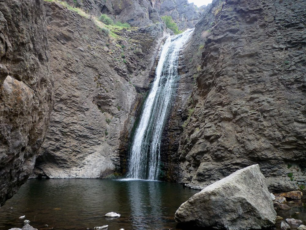
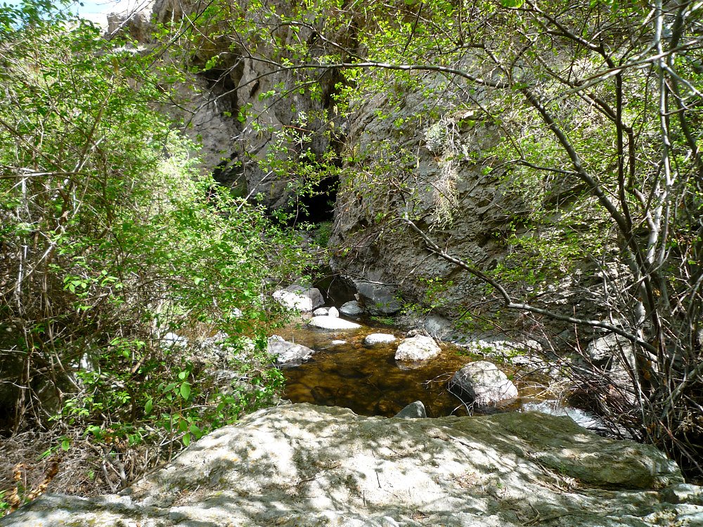
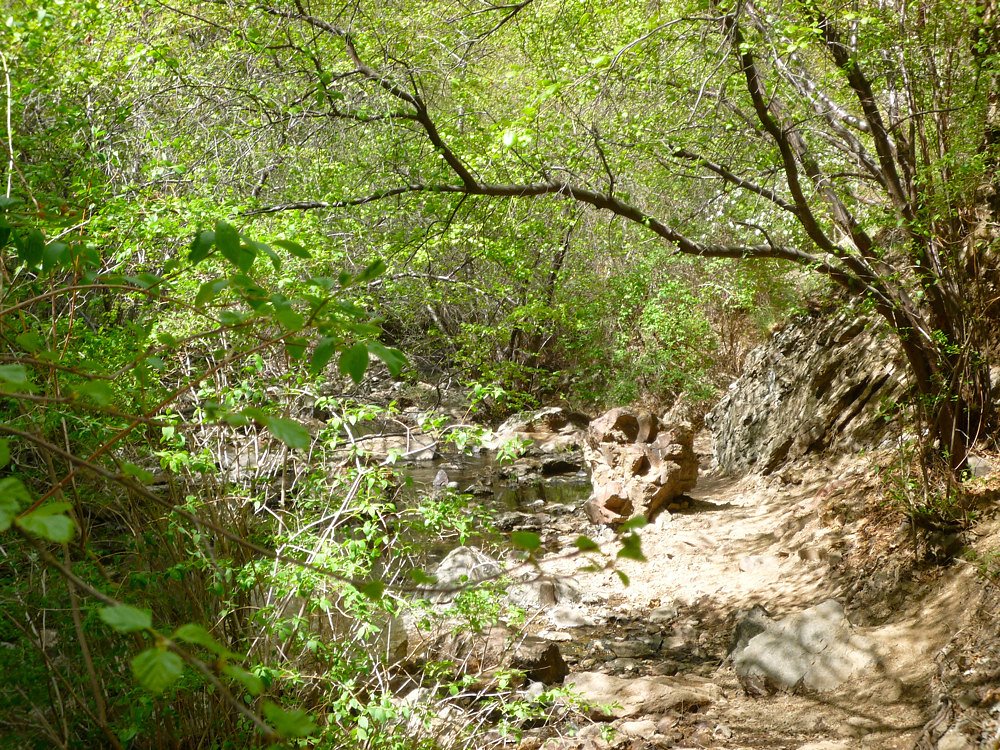

Photo Credits (5)
Difficulty
Easy
Trail Length
0.6 miles
Trail Type
Out And Back
Elevation Gain
50 ft
About Jump Creek Falls
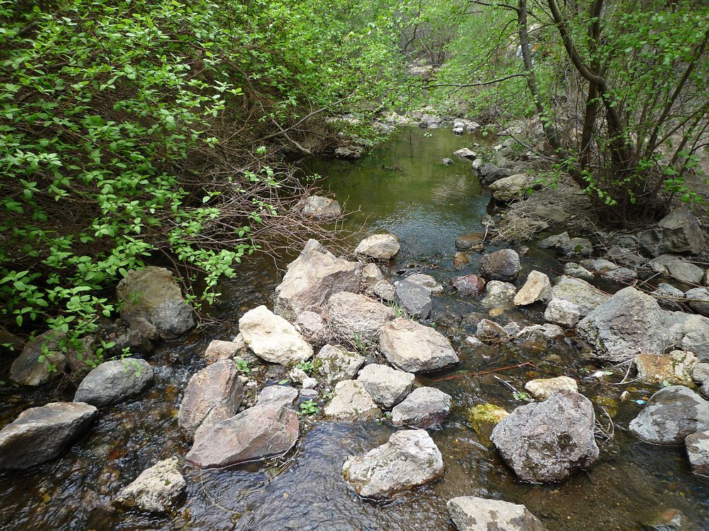
Jump Creek Falls is a striking 60-foot waterfall tucked into the Owyhee Mountains of southwestern Idaho, located in Owyhee County just to the southwest of the town of Marsing. Managed by the Bureau of Land Management’s Owyhee Field Office, the falls sit in a narrow canyon carved from volcanic rock, where dramatic cliffs and unique rock formations create a compact, scenic setting popular with locals and day visitors. A short approach trail leads into the canyon and delivers big views without a long commitment — the site’s accessibility and desert vegetation make it an inviting stop for families, photographers, and hikers looking for a quick nature escape on BLM public land. Expect a peaceful canyon atmosphere at the base of the falls and bring sun protection and water for the typically dry surroundings.
The Setting
Jump Creek Falls sits at 2,687 feet within Owyhee Field Office, fed by the Boise River, in the hills of Idaho. The falls drop 60 feet.
Height: 60 feet
Trail & Hike Details
The Approach
The easy 0.6-mile out-and-back trail gains 50 feet of elevation on the way to the falls.
Trail Description
The Jump Creek Falls hike is an easy, out-and-back route of roughly 0.6 miles with about 50 feet of elevation gain, making it suitable for most visitors including families. The path is well-maintained and follows a scenic canyon corridor with desert plants and distinctive rock formations, ending at the 60-foot waterfall and the small pool at its base. Difficulty is rated easy and the grade is minimal, so this short trail is a convenient option for a brief outdoor outing.
What to Expect
The falls drop 60 feet. Swimming is permitted. Dogs are welcome.
Accessibility
The trail is short and relatively flat, but the surface may be uneven. Contact the managing agency for accessibility details.
Frequently Asked Questions
🐶 Are Dogs Allowed at Jump Creek Falls?
✅ Dogs are allowed
Are There Any Fees or Permits Required?
🆖 No fees required
🏊 Is There Swimming at Jump Creek Falls?
✅ Swimming is allowed
When to Visit
Spring and early summer are the best times to visit, as the waterfall typically has the most water flow during these seasons. Fall is also a pleasant time to visit due to cooler temperatures.
Seasonal Access
The best time to visit is Spring, Summer, and Fall. Winter access may be limited.
Safety Information
Be cautious of slippery rocks near the waterfall and along the trail. Watch for snakes, especially during warmer months. Avoid visiting during heavy rain, as flash flooding may occur in the canyon.
Current Water Conditions
Based on a USGS gauge 17.8 miles away
1,010 ft³/s
Current discharge — how much water is flowing
Higher than usual for this time of year
Based on 10 years of record
7.30 ft
Water depth at gauge
63°F
CoolRefreshing for swimming
7-Day Discharge Trend
What does this mean for your visit?
The water is flowing higher than usual for this time of year. Water temperature is a refreshing 63 degrees F, good for a quick swim.
About This Gauge
This gauge is on a regional waterway. Conditions at the falls may differ, especially after local rain.
7-Day Flow Outlook
Based on the USGS gauge BOISE RIVER AT CALDWELL, ID (29 km away).
Today
Strong
996 cfs
10/10Tomorrow
Strong
1094 cfs
10/10Wed
Strong
1077 cfs
10/10Thu
Strong
983 cfs
10/10Fri
Strong
921 cfs
10/10Sat
Strong
927 cfs
10/10Sun
Strong
1020 cfs
10/10Best window: Today — strong flow, partly sunny (trip score 10/10).
Best time of year: this gauge typically runs highest from late March to late June, peaking in April.
How we calculate this
This is a transparent outlook, not a precise forecast. We take the waterfall's current flow strength (how it ranks against its historical normal for today, from the nearest USGS stream gauge), carry that ranking forward along the gauge's seasonal curve, and nudge it for forecast rain. Confidence is highest for the next day or two and falls further out. Always check official conditions and your own judgment before visiting — high flows can be dangerous.
Know when to go.
Get a free email alert when waterfalls near Homedale hit peak flow. We only send when conditions are worth the trip — no weekly newsletters, no spam.
Weather Forecast
Location & Access
Getting There
Jump Creek Falls is located near Marsing, Idaho. From Marsing, take Highway 95 south, then turn west onto Cemetery Road, which becomes Jump Creek Road. Follow the signs to the Jump Creek Recreation Area parking lot.
Get Directions on Google MapsParking
There is a designated parking area at the Jump Creek Recreation Area, which is free to use. The lot is gravel and can accommodate several vehicles, but it may fill up during peak times.
Elevation
2,687 feet above sea level
Coordinates
43.476823° N, -116.925422° W
Land Management
Managed by BLM
Visitor Tips & Gear
Visit early in the morning or on weekdays to avoid crowds. Wear sturdy shoes, as the trail can be rocky in some sections. Bring plenty of water, especially during the summer months, as the area can get very hot. Be cautious of slippery rocks near the waterfall.
As an Amazon Associate, we earn from qualifying purchases.
For this easy 0.6 miles trail, lightweight trail shoes and a water bottle are usually sufficient. Sun exposure on the trail makes good sun protection a must in summer.

Polarized Sunglasses (Knockaround)
Cuts glare off the water so you actually see the falls — and your photos turn out better too.

Columbia Watertight II Rain Jacket
Packs into its own pocket, seam-sealed, and keeps you dry from spray and surprise rain.

Earth Pak Waterproof Dry Bag
Keeps your phone and gear dry when waterfall mist soaks everything else.

Waterproof Phone Pouch (AiRunTech)
Cheap insurance — take photos right next to the falls without killing your phone.

JOBY GorillaPod Starter Kit
Wraps around railings and rocks for long-exposure waterfall shots — no flat surface needed.

Osprey Daylite Daypack
Light, organized, and just the right size for a day hike — fits water, snacks, and layers.
Where to Stay

Caldwell Country Home on Quiet Acreage

My Place Hotel-Boise-Nampa, ID-Idaho Center

TownePlace Suites by Marriott Nampa

Modern Cabin Vibes, Vaulted ceilings, Sleeps 8!
Browse vacation cabins and private rentals nearby
Unique outdoor stays — tents, yurts, and treehouses
Rent a campervan or RV for your waterfall road trip
Some links are affiliate links. We may earn a commission at no extra cost to you.
Nearby Campground
Slocum Creek Campground
22.5 miles away · 0 sites
Nestled in a side canyon near the mouth of Leslie Gulch, Slocum Creek Campground makes a good base for gulch explorations. Cool off in the waters of nearby Lake Owyhee or hike the Leslie Gulch Area of Critical Environmental Concern. The campground includes nine campsites, eight of which contain some accessible amenities. The low light of early morning and late evening transforms the abutting rock outcrops of Slocum Creek Wilderness Study Area into magnificent fiery wonder.Know Before You GoCampin
Book on Recreation.govNearby Hot Springs
Hot springs near Homedale, Idaho

Givens Hot Springs
Givens Hot Springs pumps 117°F water into a swimming pool complex at 2,277 feet in Owyhee County, making it one of the few comm...

South Black Willow Spring
South Black Willow Spring flows at 71°F on BLM land in Idaho's Canyon County, emerging at 2,315 feet elevation near the Oregon ...
Unnamed Spring Owyhee County 3
Located 3,388 meters (2.1 miles) from the nearest road at 2,659 feet elevation in remote Owyhee County backcountry, this hot sp...
Deer Butte Hot Spring
Deer Butte Hot Spring flows at 115 degrees Fahrenheit along Owyhee Lake Road, requiring just 142 feet from pavement at 2,430 fe...
Mitchell Butte Hot Spring
Mitchell Butte Hot Spring flows at 144°F along Owyhee Lake Road in Malheur County, creating one of Oregon's far eastern thermal...
Snively Hot Spring
Snively Hot Spring emerges at 170°F on BLM land in Malheur County, making it one of the hottest accessible thermal features in ...
Looking for a soak after your hike? Explore more hot springs near Homedale, Idaho on SoakingSprings.
Explore Idaho springsAdditional Information
Nearby Attractions
Nearby attractions include the Owyhee Mountains, Lake Lowell, and the Snake River. The area also offers opportunities for hiking, birdwatching, and exploring the desert landscape.
Wildlife
The area is home to various wildlife, including birds, lizards, and small mammals. Visitors may also spot snakes, so caution is advised.
Cities near Jump Creek Falls
Writing about Jump Creek Falls? Embed this waterfall on your site for free.