
Photo Credits (4)
Difficulty
Moderate
Trail Length
2.4 miles
Trail Type
Out And Back
Elevation Gain
350 ft
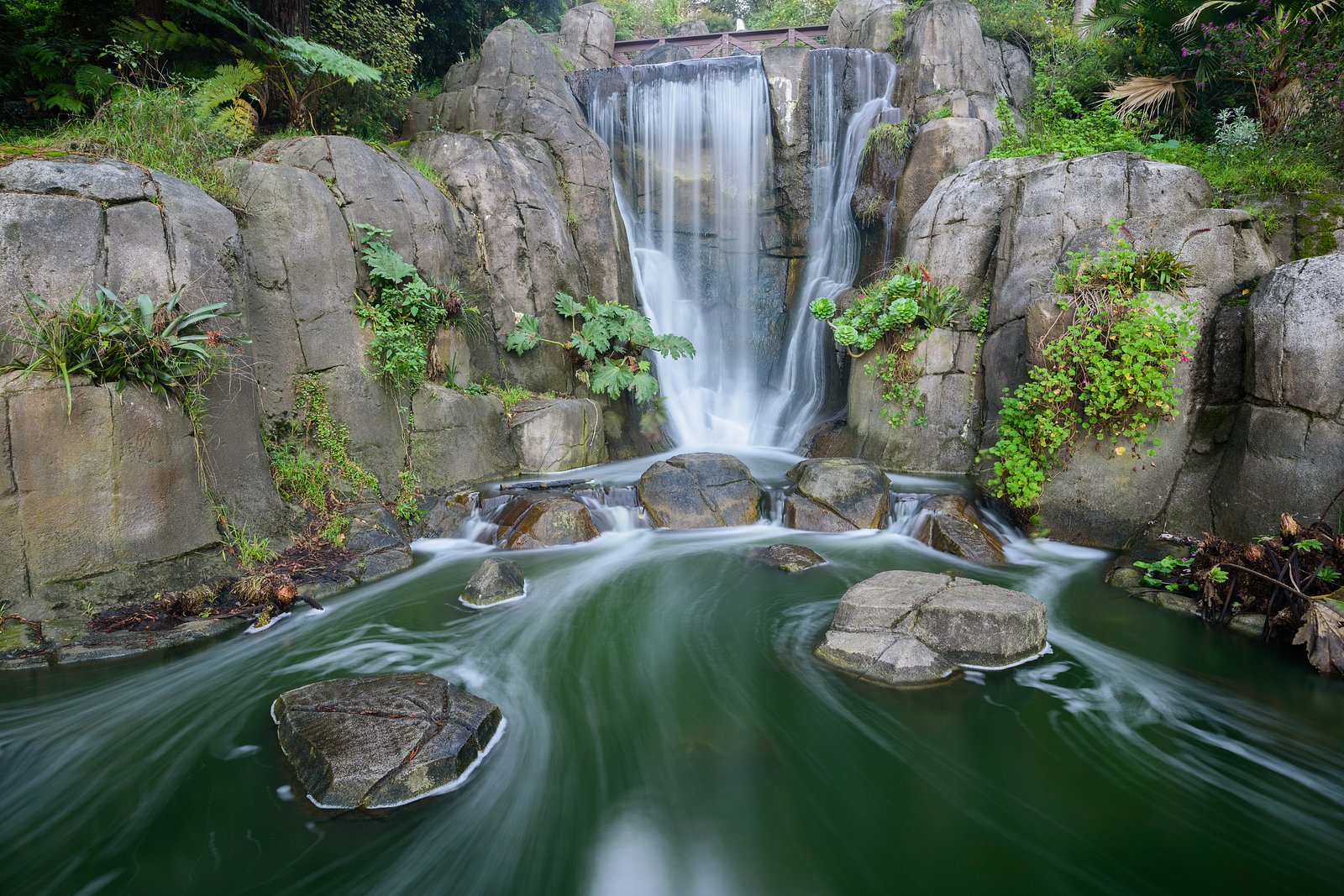
About Huntington Falls
Huntington Falls sits on the Huntington River in Vermont, offering a peaceful riverside cascade that attracts hikers and photographers looking for a scenic short outing. The falls are set in a wooded stretch of river, providing a quiet natural stop that rewards visitors with classic Vermont woodland and water views. Most visitors reach the falls via a moderate out-and-back hike of about 2.4 miles with roughly 350 feet of elevation gain. The route makes for a rewarding half-day trip; bring sturdy footwear and be prepared for uneven, sometimes rocky sections as you approach the stream and falls.
The Setting
Huntington Falls sits at 207 feet along the New Haven River @ Brooksville,, in the coastal lowlands of Vermont.
Trail & Hike Details
The Approach
The moderate 2.4-mile out-and-back trail gains 350 feet of elevation on the way to the falls.
Trail Description
This route is a 2.4-mile out-and-back trail with approximately 350 feet of elevation gain and a moderate difficulty rating. Official USFS trail surface, grade, or trail class are not documented for this approach; descriptively, hikers should expect uneven footing and short steeper pitches near the river. The trail is suitable for day hikers prepared for natural trail conditions—sturdy shoes and caution around wet rocks are recommended.
What to Expect
Visitors can expect a peaceful natural setting with cascading water and lush surroundings. The falls are a great spot for photography and relaxation. Seasonal changes may affect water flow, with spring and early summer offering the most dramatic views.
Accessibility
The trail is not wheelchair accessible. Uneven terrain and elevation changes require steady footing.
Frequently Asked Questions
🐶 Are Dogs Allowed at Huntington Falls?
❌ Dogs are not allowed
Are There Any Fees or Permits Required?
🆖 No fees required
🏊 Is There Swimming at Huntington Falls?
❌ Swimming is not allowed
When to Visit
Spring and early summer are ideal for visiting Huntington Falls due to higher water flow. Fall offers beautiful foliage, while winter may provide unique frozen waterfall views, though access could be more challenging.
Seasonal Access
The best time to visit is Spring, Summer, and Fall. Winter access may be limited.
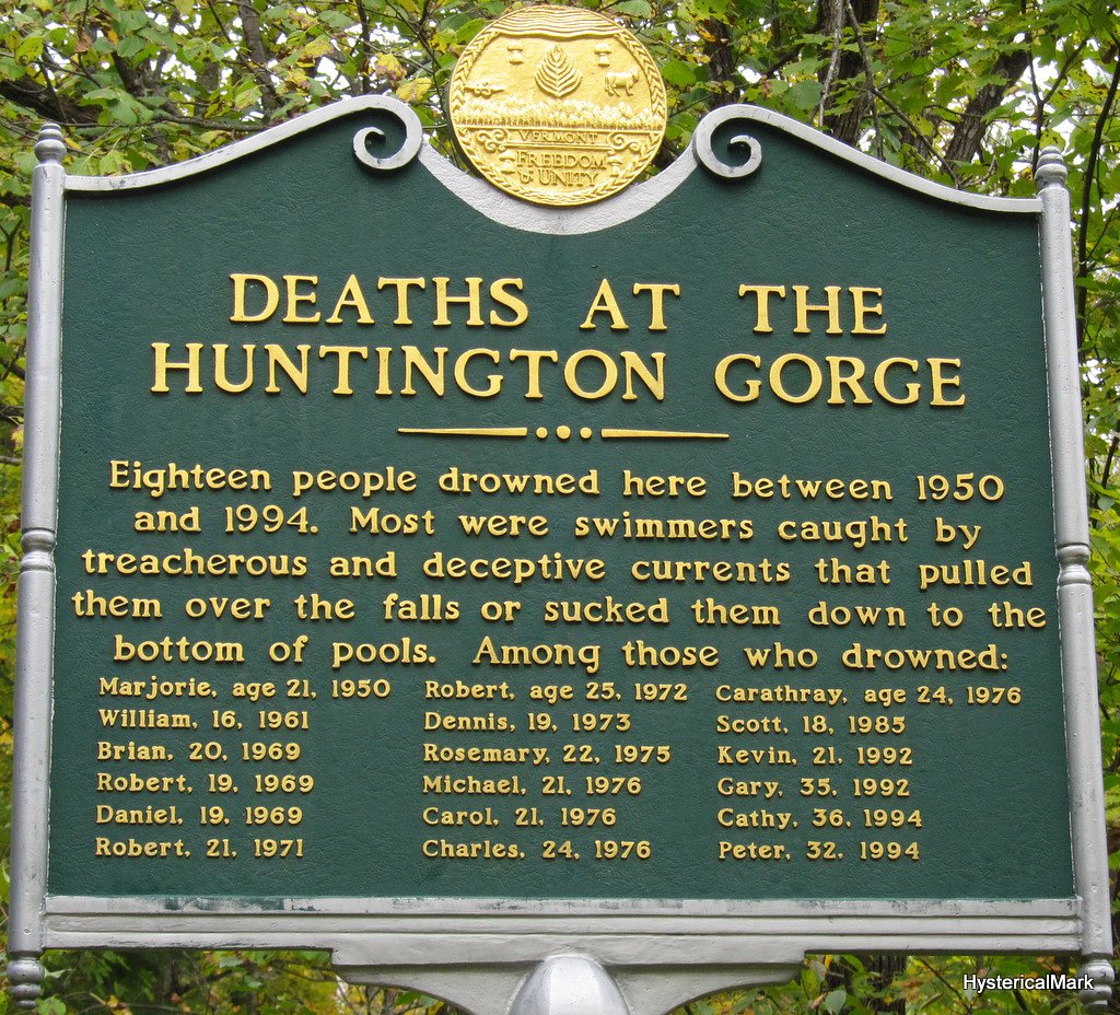
Safety Information
Visitors should be cautious of slippery rocks, strong currents, and potential hazards during winter months, such as ice. Always stay on safe, stable ground and avoid venturing too close to the edge of the falls.
Current Water Conditions
139 ft³/s
Current discharge — how much water is flowing
About average for this time of year
Based on 36 years of record
3.46 ft
Water depth at gauge
7-Day Discharge Trend
What does this mean for your visit?
Flow is about average for this time of year.
About This Gauge
7-Day Flow Outlook
Based on the USGS gauge NEW HAVEN RIVER @ BROOKSVILLE, NR MIDDLEBURY, VT (2 km away).
Today
Low
159 cfs
3/10Tomorrow
Low
149 cfs
3/10Thu
Low
156 cfs
3/10Fri
Low
149 cfs
3/10Sat
Low
135 cfs
3/10Sun
Low
126 cfs
3/10Mon
Low
137 cfs
3/10Best window: Today — low flow, mostly sunny then slight chance showers and thunderstorms (trip score 3/10).
Best time of year: this gauge typically runs highest from early March to mid May, peaking in April.
How we calculate this
This is a transparent outlook, not a precise forecast. We take the waterfall's current flow strength (how it ranks against its historical normal for today, from the nearest USGS stream gauge), carry that ranking forward along the gauge's seasonal curve, and nudge it for forecast rain. Confidence is highest for the next day or two and falls further out. Always check official conditions and your own judgment before visiting — high flows can be dangerous.
Know when to go.
Get a free email alert when waterfalls near New Haven hit peak flow. We only send when conditions are worth the trip — no weekly newsletters, no spam.
Weather Forecast
Location & Access
Getting There
Huntington Falls is located near the town of Huntington, Vermont. Access is typically via local roads, and visitors should follow signs or GPS directions to the falls. The exact location may require a short walk from the parking area.
Get Directions on Google MapsParking
Parking availability is limited and may consist of roadside pull-offs or small designated areas. Visitors should plan accordingly and avoid blocking traffic.
Elevation
207 feet above sea level
Coordinates
44.070336° N, -73.195953° W
Visitor Tips & Gear
Visit during the spring or after heavy rains for the best water flow. Bring sturdy footwear and be cautious of slippery rocks near the falls. Check local conditions before visiting, especially during winter months when ice may make access hazardous.
As an Amazon Associate, we earn from qualifying purchases.
With 2.4 miles and 350 ft of elevation gain, sturdy boots and trekking poles will help on this moderate trail. Sun exposure on the trail makes good sun protection a must in summer.

Polarized Sunglasses (Knockaround)
Cuts glare off the water so you actually see the falls — and your photos turn out better too.

Columbia Watertight II Rain Jacket
Packs into its own pocket, seam-sealed, and keeps you dry from spray and surprise rain.

Earth Pak Waterproof Dry Bag
Keeps your phone and gear dry when waterfall mist soaks everything else.

Waterproof Phone Pouch (AiRunTech)
Cheap insurance — take photos right next to the falls without killing your phone.

Timberland Euro Sprint Mid Waterproof
Trusted waterproof boot with premium leather and grippy rubber sole — reliable on rocky, wet trails.

TrailBuddy Trekking Poles
Lightweight aluminum, cork grips, and flip-locks that actually hold — a best-seller for good reason.
Where to Stay

Middlebury Inn

Private 5-Acre Escape - Pool, Lake & Gardens

Madbush Falls

Courtyard Middlebury
Browse vacation cabins and private rentals nearby
Unique outdoor stays — tents, yurts, and treehouses
Rent a campervan or RV for your waterfall road trip
Some links are affiliate links. We may earn a commission at no extra cost to you.
Nearby Campground
MOOSALAMOO CAMPGROUND
13.4 miles away · 20 sites
Overview Moosalamoo Campground is a small remote campground located at the base of Mt. Moosalamoo, near Voter Brook. A large mowed grass field in the middle of the campground is good for a variety of activities, especially for groups with children. There are 19 campsites (including one host site), six vault toilets and potable water is available on site via a hand-pump.Recreation The Moosalamoo National Recreation Area consists of 16,000 acres abounding with recreation opportunities. With over 70
Book on Recreation.govAdditional Information
Nearby Attractions
The town of Huntington and nearby Camel's Hump State Park offer additional outdoor activities and scenic views.
Wildlife
The area around Huntington Falls is home to various wildlife, including birds, small mammals, and aquatic species. Visitors should respect the natural habitat.
Cities near Huntington Falls
Other waterfalls named Huntington Falls
1 other waterfall shares this name across the U.S.
Writing about Huntington Falls? Embed this waterfall on your site for free.